GEOMATICA - International Cartographic ...
←
→
Transcription du contenu de la page
Si votre navigateur ne rend pas la page correctement, lisez s'il vous plaît le contenu de la page ci-dessous
VOLUME 65 NUMBER 1, 2011
GEOMATICA
THE JOURNAL OF GEOSPATIAL INFORMATION SCIENCE, TECHNOLOGY AND PRACTICE
LA REVUE DES SCIENCES DE LINFORMATION GÉOSPATIALE, DE LA TECHNOLOGIE ET DE LA PRATIQUE
CARTOGRAPHY IN CANADA 2007-2011
LA CARTOGRAPHIE AU CANADA DE 2007-2011
VOLUME 65, NUMÉRO 1, 2011
CANADIAN NATIONAL REPORT TO
THE INTERNATIONAL CARTOGRAPHIC
ASSOCIATION
Fifteenth General Assembly, Paris, France, July 3-8, 2011
Janet E. Mersey Guest Editors: Eric Kramers
Janet E. Mersey, Chair of the Canadian National Committee to the ICA
Principal Deputy Canadian
Eric Kramers, Natural Resources Canada, Deputy Canadian Delegate to the ICA
Canadian Delegate to the
Delegate to the F ICA
ICA 8
It is a pleasure to present Canada’s the Canada Centre for Remote Sensing, out by federal and provincial/territori-
national report to the ICA, on behalf of was used to update glacial extents. The al government agencies; national soci-
the Canadian Institute of Geomatics most up-to-date International Bathymetric eties and associations; and educational
(CIG), to the delegates of the fifteenth Chart of the Arctic Ocean was innovatively institutions in Canada. These reports
General Assembly. This is in accor- adapted and integrated into this new map. clearly illustrate the importance and
dance with Article 5 of the ICA statutes The articles in this report were scope of geomatics in Canada, and
on the occasion of the XXV obtained in response to a call for papers, provide rich detail showcasing the
International Cartographic Conference and underwent the journal’s usual rigorous breadth of geomatics science that is
in Paris, France. Titled Cartography in peer review process. The three-featured part of the work of many Canadians.
Canada: 2007-2011, this comprehen- articles illustrate the thematic breadth of The complexity and diversity of carto-
sive report is published as a special the field of geomatics, in this case encom- graphic and geomatics activity in
issue of the Canadian quarterly journal passing topographic mapping, remote Canada demonstrates how vital they
Geomatica and is distributed to all sensing, and online atlas creation. The are to all sectors of government, indus-
members of the Canadian Institute of paper by Daniel Clavet, from Natural try and education. These reports also
Geomatics. This special issue will be Resources Canada, explains the innova- show how difficult it is to imagine a
the first issue of Geomatica published tive use of multiple data sources, includ- nation and a World without the high
and available online through the CIG ing imagery from Canada’s Radarsat 2 level of integrated maps and data we
website. While bringing unique chal- satellite, to produce topographic maps of currently use and experience daily.
lenges to the publishing process, it northern Canada. By 2012, the CartoNord This publication was a team
allows for a high quality, easily acces- project will have achieved its objective of effort, and we would like to sincerely
sible, full colour document. This report providing complete coverage of all of thank everyone who contributed his
contains contributions from over 50 northern Canada at 1:50 000. Radarsat or her time and energy in its prepara-
geomatics specialists throughout imagery is also central to the article by tion. This includes authors who sub-
Canada and reflects the high level of Gangyao Kuang, Jonathan Li and Zhiguo mitted material and those unmen-
activity in this sector in Canada in gov- He. They derive and test a sophisticated tioned, but equally important, indi-
ernment, industry and education. edge detection algorithm, allowing for viduals who reviewed this material.
Canada’s national report is also a accurate detection of water bodies from Special thanks goes to Carol Railer,
compendium of peer-reviewed feature SAR imagery with high noise speckle. Production Manager of Geomatica,
articles and activity reports from Lastly, a contribution by Glenn Brauen, for her endless patience and advice
organizations with a geomatics man- Stephanie Pyne, Amos Hayes, J.P. Fiset throughout the compilation process
date, which together highlight and D.R. Taylor, a multidisciplinary and Jean Thie, Editor.
Canada’s cartographic achievements research team at the Geomatics and We look forward to participating
over the past five years. The cover of Cartographic Research Centre at Carleton in the XXV International Cartographic
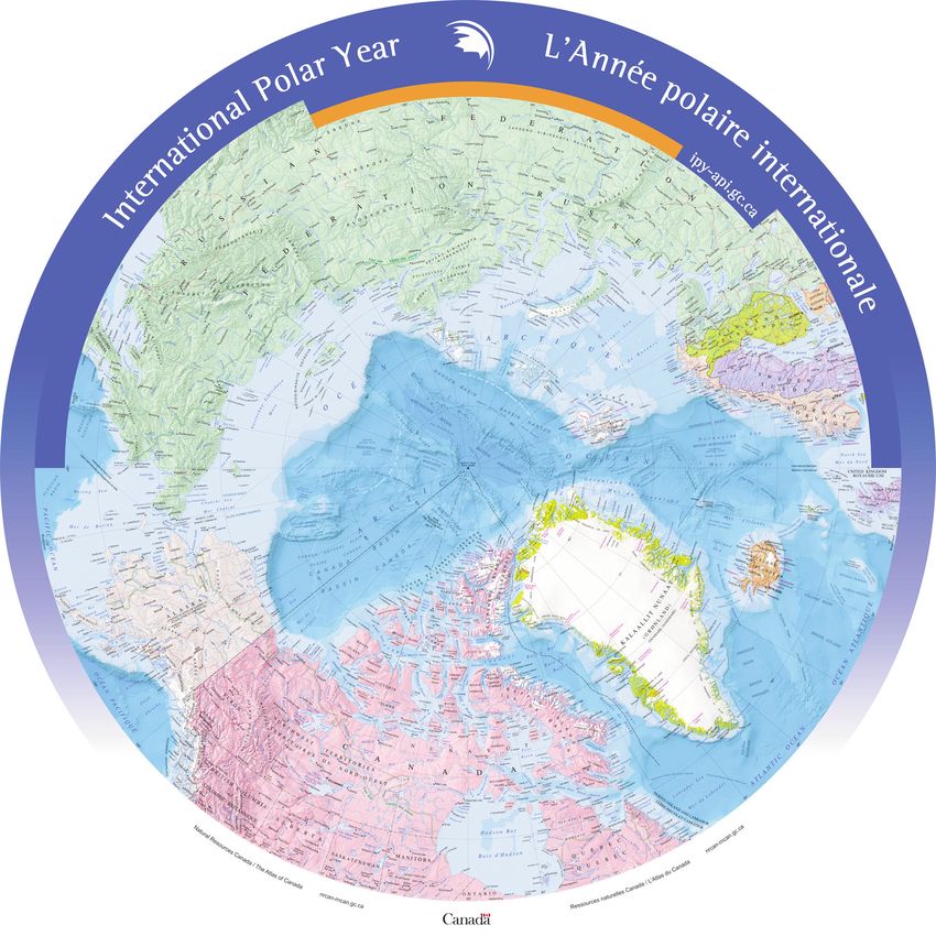
the report features the award winning University, highlights the creative design Conference, set to commence in July
map of the North Circumpolar Region of a web atlas developed with open source 2011, in Paris, France. A stimulating
and was produced by Natural software. Focusing on the Lake Huron and diverse program has been planned,
Resources Canada’s, Mapping and Treaty Relationship Process, the atlas rep- thanks to the admirable efforts of the
Information Branch, Atlas of Canada resents a unique tool for expressing Local Organizing Committee, the
in 2008. The map incorporated consid- geonarratives or stories told through maps. International Scientific Committee,
erable new data for all map features. Also included in this issue are summa- the French Scientific Committee and
Circumpolar MODIS imagery, from ry reports of cartographic initiatives carried the ICA Executive Committee. !
Vol. 65, No. 1, 2011 GEOMATICA 7
RAPPORT NATIONAL CANADIEN À
                          L'ASSOCIATION CARTOGRAPHIQUE
                                 INTERNATIONALE
                              Quinzième assemblée générale, Paris, France, 3-8 juillet 2011
   Janet E. Mersey        E                                    Rédacteurs invités :                                       Eric Kramers
                          7              Janet E. Mersey, Présidente du Comité national canadien à l'ACI
 Déléguée principale                                                                                                     Délégué adjoint
                                  Eric Kramers, Ressources naturelles Canada, Délégué adjoint canadien à l'ACI
 canadienne à l'ACI                                                                                                     canadien à l'ACI
       Au nom de l’Association canadien-      zone circumpolaire, du Centre canadien de         graphiques entreprises par les orga-
 ne des sciences géomatiques (ACSG),          télédétection, a permis de mettre à jour          nismes des gouvernements fédéraux,
 nous avons le plaisir de présenter le        l’étendue glaciaire. La Carte bathymé-            provinciaux et territoriaux, les sociétés
 rapport national canadien aux délégués       trique internationale de l’océan Arctique         et les associations nationales ainsi que
 de la quinzième assemblée générale de        la plus à jour a été adaptée et intégrée de       les établissements d’enseignement du
 l’ACI. Ceci fait conformément à l’ar-        façon novatrice dans cette nouvelle carte.        Canada. Ces rapports font nettement
 ticle!5 des statuts de l’ACI, à l’occasion        Les articles du présent rapport nous         ressortir l’importance et la portée de la
 de la XXVe Conférence internationale         ont été envoyés suite à une invitation à          géomatique au Canada, et fournissent
 sur la cartographie à Paris, France.         présenter des communications, et soumis           des détails précis démontrant l’am-
 Intitulé La cartographie au Canada :         au rigoureux processus habituel de publica-       pleur des sciences géomatiques qui
 2007-2011, ce rapport détaillé paraît en     tion de Geomatica, soit une évaluation par        font partie du travail de nombreux
 tant que numéro spécial de la publica-       les pairs. Les trois articles illustrent l’am-    Canadiens. La complexité et la diversité
 tion trimestrielle canadienne Geomatica      pleur thématique du domaine de la géoma-          des activités cartographiques et géoma-
 et il est distribué à tous les membres de    tique, qui englobe dans le cas présent la         tiques au Canada révèlent à quel point
 l’Association canadienne des sciences        cartographie topographique, la télédétec-         ils sont vitaux dans tous les secteurs
 géomatiques. Ce numéro spécial sera la       tion et la création d’atlas en ligne. L’article   du gouvernement, de l’industrie et de
 première parution de Geomatica diffu-        de Daniel Clavet, de Ressources naturelles        l’enseignement. Ces rapports prou-
 sée et disponible en ligne sur le site Web   Canada, explique l’utilisation novatrice de       vent également combien il est difficile
 de l’ACSG. Tout en introduisant des          sources multiples de données, notamment           d’imaginer une nation et un monde sans
 enjeux uniques dans le processus de          l’imagerie du satellite RADARSAT-2 du             le degré élevé d’intégration des cartes et
 publication, cela nous a permis de créer     Canada, pour produire des cartes topogra-         des données que nous utilisons et expé-
 un document de qualité supérieure, faci-     phiques du nord du Canada. D’ici 2012, le         rimentons chaque jour actuellement.
 lement accessible, pleine couleur. Ce        projet CartoNord aura atteint son objectif              La présente publication représente
 rapport existe grâce à la contribution de    d’effectuer une couverture complète de tout       un effort d’équipe, et nous souhaitons
 plus de 50 spécialistes des sciences géo-    le nord du Canada à l’échelle de 1/50!000.        remercier sincèrement les personnes qui
 matiques du Canada et tient compte du        L’imagerie RADARSAT est aussi au cœur             ont consacré leur temps et leurs énergies
 niveau élevé d’activités dans ce secteur     de l’article de Gangyao Kuang, Jonathan Li        à sa préparation, dont les auteurs qui ont
 au Canada, dans les gouvernements,           et Zhiguo He. Ils calculent et testent un         présenté des articles et les personnes,
 l’industrie et l’éducation.                  algorithme haut de gamme de détection des         non mentionnées, mais tout aussi
       Le rapport national du Canada se       contours, permettant une détection exacte         importantes, qui ont évalué ces articles.
 veut également un recueil d’articles         des plans d’eau à partir d’images RSO avec        Nous offrons nos remerciements par-
 évalués par des pairs et de rapports         bruits de chatoiement élevés. Enfin, la           ticuliers à Carol Railer, gestionnaire de
 sur les activités des organismes ayant       contribution de Glenn Brauen, Stephanie           la production de Geomatica, pour son
 un mandat géomatique, ce qui, de             Pyne, Amos Hayes, J.P. Fiset et D.R.              infinie patience et ses conseils tout au
 concert, met en valeur les réalisations      Taylor, une équipe de recherche pluridisci-       long de la compilation ainsi qu’à Jean
 cartographiques du Canada au cours           plinaire du centre de recherche en géoma-         Thie, rédacteur en chef.
 des cinq dernières années. La couver-        tique et en cartographie de l’Université                Nous nous réjouissons de participer
 ture du rapport présente la carte pri-       Carleton, a mis en valeur la conception           à la XXVe Conférence internationale sur
 mée de la région circumpolaire-Nord          graphique d’un atlas Web préparé avec un          la cartographie, qui doit commencer en
 et a été produite en 2008 par l’Atlas        logiciel en libre accès. Centré sur le pro-       juillet 2011 à Paris, France. Les organi-
 du Canada, Direction de l’information        cessus de relations pour le traité du lac         sateurs ont prévu un programme stimu-
 cartographique, Ressources naturelles        Huron, l’atlas représente un outil unique         lant et diversifié, merci pour leurs efforts
 Canada. La carte incorpore une quan-         permettant d’exprimer les géonarrations ou        remarquables au comité organisateur
 tité importante de nouvelles données         les histoires racontées grâce aux cartes.         local, au Comité scientifique internatio-
 pour toutes les entités cartogra-                 Ce numéro comprend aussi les rap-            nal, au Comité scientifique français et
 phiques. L’imagerie MODIS de la              ports sommaires sur les initiatives carto-        au Comité directeur de l’ACI. !

8 GEOMATICA                                                                                                                  Vol. 65, No. 1, 2011
G     E    O   M     A    T    I   C     A

                            NEW DATA SOURCES FOR COMPLETING
                            NATIONAL TOPOGRAPHIC MAPPING OF
                            NORTHERN CANADA AT 1:50,000
                                     Daniel Clavet, Natural Resources Canada, Centre for Topographic Information

     Complete topographic mapping coverage of Canada is essential as a basis for the sustainable develop-
ment of its resources. In 2000, the unmapped areas at a scale of 1:50,000 in the Arctic islands in Nunavut
and the Northwest Territories, amount to over 800,000 square kilometres, equivalent to approximately
1,500 map sheets. In 2003, a northern mapping project was launched to complete the topographic map cov-
erage in Northern Canada. In order to explore all possible scenarios, the Centre for Topographic
Information – Sherbrooke (CTIS) worked closely with the Canadian Space Agency and the private sector
on various feasibility tests. After investigating multiple data sources, the combination of existing aerial pho-
tography, LANDSAT 7 ETM+, SPOT5/HRS imagery, interferometric pairs of ERS 1-2 tandem and
RADARSAT-2 imagery were chosen for planimetric data and Canadian Digital Elevation Data (CDED)
acquisition. In 2004, mapping contracts were carried out on a test site and positive results from these tests
initiated the production of the unmapped areas of Canada. The planimetric vector data are available on the
                                                                                                                         Daniel Clavet
GeoGratis Web portal and the CDED data sets are available on the GeoBase Web portal.
     La cartographie topographique complète du territoire canadien est essentielle pour le développement
durable des ressources, car elle assure une géoréférence de base. En 2000, les régions non cartographiées
à l’échelle de 1/50 000 dans les îles de l’Arctique au Nunavut et aux Territoires du Nord-Ouest couvraient
plus de 800 000 kilomètres carrés, soit environ 1 500 feuillets cartographiques. En 2003, un projet de car-
tographie topographique du Nord canadien a été initié afin de compléter la couverture cartographique.
Différentes technologies satellitales et scénarios de production ont été investigués par le Centre d’infor-
mation topographique – Sherbrooke (CIT-S) en collaboration avec l’Agence spatiale canadienne et l’in-
dustrie privée pour effectuer des tests de faisabilité. Après avoir testé plusieurs sources de données, des
combinaisons de photographies aériennes, d’images des satellites LANDSAT 7 ETM+, SPOT5/HRS, de
paires interférométriques ERS1-2 et d’images RADARSAT-2 ont été retenues pour l’acquisition de données
planimétriques et altimétriques. En 2004, des contrats de production expérimentale ont été émis sur un site
test et les résultats positifs de ces travaux ont permis de débuter la production des zones non cartographiées
du Canada. Les données planimétriques vectorielles sont disponibles sur le portail Web GéoGratis et les
Données numériques d’élévation du Canada (DNEC) sont disponibles sur le portail Web GéoBase.

Introduction
Unmapped Areas of Canada
     The Centre for Topographic Information pro-          which the CartoNord project was launched. The
duces and maintains topographic data for Canada at        essential thrust was to develop the capabilities for
scales of 1:250,000 and 1:50,000. While the               gathering digital topographic data at the scale of
1:250,000 scale coverage was completed in 1970            1:50,000 in northern Canada.
[Sebert 1970], the 1:50,000 scale map production               Mapping this area is a big challenge. It is a
was stalled in the late nineties, leaving a large por-    remote territory with limited access and a short
tion of northern Canada unmapped. Complete topo-          summer season, complicating access to quality
graphic mapping coverage of Canada’s North is             checkpoints. The summer length is a critical factor
essential as a basis for the sustainable development      as it’s difficult to identify terrain features under
of its resources. The unmapped areas, as of 2003, in      snow cover. Cloud cover is also an important fac-
the Nunavut and the Northwest Territories amount to       tor, as the main data sources are aerial or optical
over 800,000 square kilometres, equivalent to almost      satellites images. The terrain is also variable from
1,500 map tiles (Figure 1). This is the context in                                                 GEOMATICA Vol. 65, No. 1, 2011 pp. 9 to 14
G     E    O   M    A    T    I    C    A

                            DETECTING WATER BODIES ON
                            RADARSAT IMAGERY
                                      Gangyao Kuang, and Zhiguo He, School of Electronics Science and Engineering,
                                      National University of Defense Technology, China
                                      Jonathan Li, Department of Geography and Environmental Management,
                                      University of Waterloo, Waterloo, Ontario

     This paper presents a novel geodesic active contour (GAC) model based on an edge detector for rapid
detection of water bodies from spaceborne synthetic aperture radar (SAR) imagery with high speckle noise.
The original edge indicator function based on gradients is replaced by an edge indicator function based on
the ratio of exponentially weighted averages (ROEWA) operator. Thus, the capability of edge detection and
the accuracy of locating edges are greatly improved, which makes the model more appropriate for SAR
images. In addition, an enhancing term is added to the original model’s energy function in order to boost
the strength for the contour’s evolution. An unconditionally stable additive operator splitting (AOS) scheme
and a fast algorithm for re-initialization of the level set function are adopted, which not only enhances the
model’s stability, but also speeds up the model’s convergence remarkably. The experimental results on sim-
ulated and real RADARSAT-1/-2 images show its efficiency and accuracy.
     Cet article présente un nouveau modèle de contour actif géodésique (GAC, de l’anglais geodesic active               Gangyao Kuang
contour) fondé sur un détecteur de contours pour détection rapide des plans d’eau à partir d’images radar à
synthèse d’ouverture (RSO) spatioporté avec bruits de chatoiement élevés. La fonction originale d’indicateur
de contours fondée sur les gradients est remplacée par une fonction d’indicateur de contours fondée sur le
rapport d’un opérateur de moyennes pondérées de façon exponentielle (ROEWA). Par conséquent, la capa-
cité de détection des contours et l’exactitude des contours localisés sont grandement améliorées, ce qui rend
le modèle plus adéquat pour les images RSO. De plus, une modalité d’amélioration s’ajoute à la fonction
d’énergie du modèle original dans le but de renforcir la puissance de l’évolution des contours. On a adopté
un scénario de séparation d’opérateur additif (SOA) inconditionnellement stable et un algorithme rapide pour
la réinitialisation des surfaces de niveau, ce qui non seulement améliore la stabilité du modèle, mais accélère
aussi la convergence du modèle de façon remarquable. Les résultats expérimentaux sur des images simulées
et réelles RADARSAT-1/-2 démontrent son efficience et son exactitude.

                                                                                                                          Jonathan Li
1. Introduction                                                                                                        junli@uwaterloo.ca

     Water resources play an important role in envi-      tion the cloud penetration capabilities that are funda-
ronmental, transportation and regional planning,          mental when mapping transient waters typically
disaster management, industrial and agricultural          associated to rainy periods. However, speckle noise
production. Detecting water bodies is the first step      usually occurs in SAR images due to the nature of
for any planning, especially for Ontario, Canada,         coherent imaging. It makes feature extraction from
where the land-cover is dominated by water bodies.        SAR image much more difficult than that from opti-
Earth observation data, including spaceborne syn-         cal imagery. In order to eliminate the speckle effects,
thetic aperture radar (SAR) images, when used             a significant research effort has been devoted to the
jointly with in situ data, can provide an essential       design of effective segmentation methods over last
contribution for the creation of inventories of surface   few decades. Among them, four types of the seg-                   Zhiguo He
water resources, the extraction of thematic maps rel-     mentation methods have been commonly used,
evant for hydrogeographical studies and models            namely, the edge-based scheme [Oliver et al. 1996;
(e.g., land cover, surface geomorphology) or for the      Collins and Kopp 2008], the Markov random field
retrieval of (bio)geographical parameters (e.g., water    (MRF) model [Fjortoft et al. 2003], level set theory
quality and temperature, soil moisture) [Shultz and       [Shu et al. 2010], and the region merging / region
Engman 2000]. SAR data are suitable for mapping           growing family of methods [Cook et al. 1994]. The
water bodies, as the signal is principally sensitive to   edge-based scheme aims to find transitions between
moisture and to surface roughness. These data can be      uniform areas, rather than directly identifying them.
preferred to optical imagery taking into considera-
                                                                                                   GEOMATICA Vol. 65, No. 1, 2011, pp. 15 to 25
G    E    O     M    A     T    I   C    A

                            ENCOURAGING TRANSDISCIPLINARY
                            PARTICIPATION USING AN OPEN SOURCE
                            CYBERCARTOGRAPHIC TOOLKIT:
                            THE ATLAS OF THE LAKE HURON TREATY
                            RELATIONSHIP PROCESS
                                      Glenn Brauen, Stephanie Pyne, Amos Hayes, Jean-Pierre Fiset and
                                      D.R. Fraser Taylor, Geomatics and Cartographic Research Centre
                                      Carleton University, Ottawa, Ontario
                                      glenn@gbrauen.ca, sapyne@gmail.com, ahayes@gcrc.carleton.ca,
                                      jp@fiset.ca, fraser_taylor@carleton.ca

     Digital web atlases can incorporate perspectives derived from diverse participants or communities to
                                                                                                                          Glenn Brauen
create and present narratives using qualitative and quantitative information structured around a set of maps
as organizational and analytical tools. Development of such an atlas requires a transdisciplinary team to
contend with complexity in subject matter, technologies, and project dynamics. Technologies required are
potentially as much an obstacle to some potential participants as they may be necessary to the fulfilment of
a project’s outreach and communication goals. This paper describes the Cybercartographic Atlas of the
Lake Huron Treaty Relationship Process, the open source atlas toolkit used to implement it, and features of
the toolkit that are intended to encourage transdisciplinary participation. The discussion explicitly address-
es issues related to the iterative processes, at multiple scales, required to develop atlas projects within an
academic research setting while using and creating open source software.
                                                                                                                         Stephanie Pyne
     Les atlas Web numériques peuvent incorporer les points de vue issus de divers participants ou commu-
nautés, afin de créer et de présenter des narrations comprenant des renseignements qualitatifs et quantitatifs
structurés à partir d’un ensemble de cartes servant d’outils organisationnels et analytiques. La préparation
d’un tel atlas requiert une équipe multidisciplinaire pour soutenir la complexité des éléments essentiels, des
technologies et des dynamiques de projet. Les technologies requises représentent tant un obstacle en puis-
sance pour certains participants éventuels qu’elles peuvent s’avérer nécessaires à l’accomplissement de la
diffusion et des objectifs de communication d’un projet. Le présent article décrit le processus et les relations
à l'implantation de l’atlas cybercartographique pour le traité du lac Huron, la trousse d'atlas, qui est un
logiciel libre, utilisée pour sa mis-en-œuvre et les caractéristiques de la trousse qui sont destinées à favoriser
la participation pluridisciplinaire. La discussion traite explicitement des questions relatives aux processus              Amos Hayes
itératifs à des échelles multiples qui sont indispensables pour élaborer des projets d’atlas dans un cadre de
recherche universitaire tout en utilisant et en créant un logiciel libre.

Introduction
     An atlas, containing an organized selection of        navigational, political, cultural, economic, social, or
maps [Wood 1987], can be an excellent medium for           various combinations of these. In recent years, criti-
conveying a range of perspectives on the many              cal approaches to cartography [Wood and Fels 1986;           Jean-Pierre Fiset
aspects of a topic, issue or theme. Conventional           Harley 1989; Pickles 1995; Crampton and Krygier
atlases have historically focused their central themes     2005] have considered the political nature of maps
around particular places or regions, such as cities or     and have looked at mapping as a process [Turnbull
towns, provinces or states, nations or continents. The     2007], both in terms of the design and development
various maps in an atlas may highlight different           of maps and in terms of their use. These approaches
types of ‘information.’ For example, they may draw         have attended to information that historically has
attention, through the use of map ordering and the         been omitted from conventional—often colonial—
relations established between themes by the atlas          maps and atlases and have expanded the scope of
narrative, to one or more of the following dimen-          possible map themes to include all manner of social         D.R. Fraser Taylor
sions that make up a ‘place’: geophysical, weather,                                                 GEOMATICA Vol. 65, No. 1, 2011 pp. 27 to 45
CANADIAN NATIONAL COMMITTEE
              FOR THE ICA
                                                      Janet E. Mersey, Chair

      Canada’s membership in the                 Delegate—Janet E. Mersey                   •   To prepare for each quadrennial
 International Cartographic Association      •   Canadian Cartographic Association              ICA General Assembly and
 is held by the Canadian Institute of            (CCA)—Roger Wheate                             International Technical Conference
 Geomatics (CIG), Canada’s oldest            •   Association of Canadian Map                    by:
 surveying and mapping organization.             Librarians and Archives (ACMLA)—
 Founded in 1882, and originally                 Colleen Beard                                  a.   Publishing a national report
 known as the Canadian Institute of          •   Deputy Delegate to the ICA—Eric                     covering government and
 Surveying, the CIG has a broad man-             Kramers                                             non-government mapping
 date to represent all the diverse aspects   •   Coordinator for the International Map               activities, cartographic edu-
 of geomatics in Canada, including               Exhibition—Dan Duda                                 cation, technological devel-
 surveying, charting, remote sensing,        •   Coordinator for the Children’s Map                  opments (including geo-
 navigation, geographic information              Competition—Karen Van Kerkoerle                     graphic information sys-
 systems, and cartography.                                                                           tems), cartographic litera-
      Recognizing that there exist within         The Chair of the Canadian National                 ture, activities of profession-
 Canada other national associations with     Committee for the ICA has a four-year term              al societies, and special
 interests in geomatics, notably the         of office coinciding with the time between              activities of interest;
 Canadian Cartographic Association           ICA General Assemblies. According to pro-          b.   Identifying key issues which
 (CCA) and the Association of Canadian       cedures outlined in the MOU, the Chair is               will be discussed and voted
 Map Librarians and Archives                 nominated by the Canadian Cartographic                  on at the General Assembly,
 (ACMLA), the Canadian Institute of          Association and ratified by the Canadian                and preparing a Canadian
 Geomatics formed the Canadian               Institute of Geomatics. Clifford Wood held              position on these issues;
 National Committee (CNC) for the            this position from 1987-1991, Norman               c.   Considering the nomination
 International Cartographic Association.     Drummond from 1991-1995, Peter Keller                   of Canadians for executive
 As defined in a Memorandum of               from 1995-2003, and Janet Mersey from                   positions and, if appropriate,
 Understanding (MOU) between the             2003-2011.                                              encouraging such individu-
 CIG and the CCA, the CNC is chaired              The mandate of the Canadian                        als to stand for election at
 by a CIG member who also serves as          National Committee, articulated in the                  the General Assembly;
 the Technical Councillor for cartogra-      Terms of Reference document, includes              d.   Ensuring that high-quality
 phy on the CIG executive. Membership        the following:                                          technical papers are pre-
 of the CNC, as described in a 2007                                                                  pared by Canadian authors
 revision to the original 1993 MOU,          •   To represent the Canadian cartographic              for presentation at the
 includes a representative from the CIG,         community internationally through                   International        Technical
 CCA and ACMLA, along with three                 Canada’s membership in the                          Conference and publication
 other members who coordinate ICA                International Cartographic Association;             in the conference proceed-
 activities such as the National reports,    •   To review and develop a national posi-              ings; and
 Canada’s      contribution      to    the       tion on administrative and cartograph-         e.   Providing a national exhibit
 International Map Exhibition and the            ic matters relevant to the International            illustrating advances in
 Children’s Map Competition. The CNC             Cartographic Association;                           Canadian cartography by
 is currently made up with representation    •   To ensure that Canada is appropriately              displaying representative
 as follows:                                     represented on ICA standing commis-                 maps, charts, atlases and
                                                 sions, ad hoc commissions, working                  other cartographic develop-
 •   Canadian Institute of Geomatics             groups, joint inter-associations work-              ments since the previous
     (CIG) and Principal ICA                     ing groups, and committees;                         conference, and

46 GEOMATICA                                                                                                          Vol. 65, No. 1, 2011
• To encourage Canadian participa- Working Group on Art and Cartography Competition were organized by Karen
tion in support of ICA education- Co-Chair: Sébastien Caquard Van Kerkoerle, while entries to the
al seminars, publication of carto- (Concordia University) International Map Exhibition were
graphic texts, and similar special coordinated by Dan Duda. The
projects. Canadian exhibit consisted of 14 paper
maps and 3 atlases, which were also
The national committee normally A proposal will be put forward in displayed at the 2010 Canadian
holds an annual meeting in conjunction Paris for the creation of a new Cartographic Association Conference
with the conference of the Canadian Commission on Art and Cartography to be in Regina, Saskatchewan. Two of our
Cartographic Association. This term, chaired by Sébastien Caquard. entries merited ICA awards.
meetings were chaired by Janet Mersey Canadians made a strong contribution Congratulations to the cartographers at
in Vancouver, British Columbia (2008), to the technical program of the 2009 ICA NRCan for their striking circular map
Wolfville, Nova Scotia (2009), and conference in Santiago, Chile. Among the of the circumpolar region entitled
Regina, Saskatchewan (2010); the next presenters from Canada were Yvan Désy International Polar Year (selected for
meeting is planned for Calgary, (NRCan), Jonathan Li (Univ. of the cover of this national report). The
Alberta, in June 2011. Waterloo), D.R. Fraser Taylor (Carleton map was awarded first place in the
Canadians continue to be actively Univ), Eric Kramers (NRCan), Janet Thematic Map Category. In the Maps
involved in ICA activities, both Mersey (Univ. of Guelph), Hansgeog based on Satellite Imagery category, a
through serving on ICA commissions Schlichtmann (Univ. of Regina), map from the North American
and working groups, and by preparing Jacqueline Anderson (Concordia Univ.), Environmental Atlas, Land Use 2005,
national submissions for ICA confer- Douglas Hagedorn (Univ. of Calgary), was awarded second place. The map is
ences. Positions currently held by Daniel Jacobson (Univ. of Calgary), the result of a multinational mapping
Canadians on ICA Commissions and Sébastien Caquard (Concordia Univ.), partnership among Canada, Mexico
Working Groups include: Songnian Li (Ryerson Univ.), and and the United States. Thanks to both
Nicholas Chrisman (Université Laval). A Karen and Dan for their efforts in
Commission on Maps and Graphics special highlight for the Canadian delega- preparing these entries.
for Blind and Partially Sighted People tion was the splendidly illustrated presen- The ICA General Assembly in
Chair: Dan Jacobson (University tation by Helen Kerfoot, an Emeritus Paris marks the end of my term as
of Calgary) Scientist with NRCan. Currently serving Chair of the CNC. I am grateful to the
Commission on Mapping from as Chair of the United Nations Group of CIG and the ICA for providing the
Satellite Imagery Experts on Geographical Names, Kerfoot opportunity to represent Canada’s car-
Vice-Chair: Jonathan Li, (University is a leading scholar in the field of geo- tographic community at the interna-
of Waterloo) graphic toponymy who has been particu- tional level. It is always a pleasure to
Commission on Theoretical Cartography larly concerned with the standardization of participate in ICA congresses and tech-
Vice-Chair: Yaïves Ferland (Defence indigenous place names and the protection nical programs, and I look forward to
R&D Canada) of cultural heritage. the exciting and diverse program
Commission on Use and User Issues Canadian entries to the 2009 Barbara planned for the ICA meeting in Paris in
Vice-Chair: Eric Kramers (NRCan) Petchenik Children’s World Map July 2011. !
GEOMATICA BACK ISSUES SALE
ANY SET OF 4 ISSUES (BEFORE 2000) $140
For Canadian Addresses (postage included)
For International and USA Add $40 for postage.
SINGLE ISSUES (BEFORE 2000) $40
Add $10 postage for International and USA
TO ORDER, CONTACT:
Canadian Institute of Geomatics 900 Dynes Road, Suite 100 D Ottawa, Ontario K2C 3L6
Telephone at (613) 224-9851 Fax (613) 224-9577
E-mail: admincig@magma.ca—Web site: www.cig-acsg.ca
VISA, MasterCard are accepted
Vol. 65, No. 1, 2011 GEOMATICA 47Federal Government
Activities 2007-2011
Activités du gouvernement
fédéral 2007-2011
Agriculture and The external Web portal provides
geospatial products and services such as
Agri-Food Canada web-based interactive maps, planning
tools, and integrated geospatial data on
Agri-Geomatics, at Agriculture land use, soil, water, climate and biodiver- Indicators (AEI) web map product
and Agri-Food Canada (AAFC), now sity. Using interoperable Geographic (http://atlas.agr.gc.ca/aei). The AEI
has an enterprise geomatics system Information System (GIS) technology, the application allows users to interac-
that provides access to an external Web portal brings together data from dispersed tively explore, and compare, a suite of
portal (i.e. http://atlas.agr.gc.ca/) and sources. It also provides expert help in ten agri-environmental indicators of
an internal Geospatial Discovery applying and interpreting the information. agri-environmental interactions and
Portal. Hosted by the new Agri- There are a number of geographic applica- risk between 1981 and 2006, allowing
Geomatics Service (AGS), the enter- tions and downloadable datasets available various calculations like annual com-
prise system was created to provide over the Internet in Canada’s two official parisons and changes over time. This
information and support for improved languages. Many organizations have con- type of analysis is very useful for
decision-making and risk manage- tributed to these data and applications, understanding the impact of policies
ment, better agricultural policies, resulting in greater value for all users. and programs. One of the newest
enhanced innovation and discovery, The Web portal has a wide range of tools, the Biomass Inventory
and improved public awareness. interactive maps. These maps provide an Mapping and Analysis Tool (BIMAT,
AGS builds upon the processes effective way to visualize and explore the http://atlas.agr.gc.ca/bimat), was
and infrastructure put in place by the data created and/or maintained by AAFC developed to broaden our knowledge
National Land and Water Information and its collaborators. Some compilations about the availability of Canadian
Service (NLWIS) Major Crown have broad public appeal, such as the residual biomass as a renewable
Project which was successfully com- Plant Hardiness Zones of Canada resource substitute for petroleum-
pleted on March 31, 2009. AGS also (http://atlas.agr.gc.ca/phz; a joint initia- based fuels and for other industrial
provides expertise on activities such tive with Natural Resources Canada) that processes. Users of the tool can make
as geospatial data management, is useful for landowners to select shelter- well-informed decisions based on
geospatial analytical services, licens- belt species for planting. Others are spatially explicit information that
ing and partnership negotiations, and important components of policy-oriented presents a comprehensive view of
training to AAFC resources. programs such as the Agri-Environmental biomass quantity and opportunity in
48 GEOMATICA Vol. 65, No. 1, 2011Canada. This tool has already been • Crop Condition Assessment Program phiques et de jeux de données télé-
used by the biomass industry to refine (CCAP) chargeables se trouvent dans Internet
their business plans based on the vol- • Drought Watch Interactive Mapping dans les deux langues officielles du
ume and sustainability of biomass • Manitoba Riparian Health Canada. De nombreux organismes ont
available at any given location. • National Ecological Framework for contribué à l’élaboration de ces don-
The enterprise system also hosts Canada nées et de ces applications, ce qui les
more than 700 datasets. One example • Plant Hardiness Zones of Canada rend encore plus utiles pour tous les
of a publicly available, downloadable • Soils of Canada utilisateurs.
dataset is the 2009 Land Cover Le portail Web offre un vaste
(http://atlas.agr.gc.ca – choose Data). Dr. Sherman D. Nelson, Director éventail de cartes interactives qui
This comprehensive, consistent, and Agri-Environmental Information and fournissent un moyen efficace de
detailed dataset has advanced our Decision Support Systems visualiser et d’explorer les données
knowledge of agricultural lands; it is Agriculture and Agri-Food Canada créées ou mises à jour par AAC et ses
based on modern remote sensing tech- http://www.agr.gc.ca/ collaborateurs. Certaines d’entre elles
niques and it is used as a foundation for attirent un vaste public, comme les
a diverse set of agri-environmental Agriculture et Zones de rusticité des plantes au
models that will form a baseline for Canada (http://atlas.agr.gc.ca/zrp)
assessing change into the future. Agroalimentaire Canada (site exploité de concert avec
Another newly completed geospatial Ressources naturelles Canada), qui
product available to the public is the L’agrogéomatique à Agriculture et sont utiles lorsque les propriétaires
Daily 10 km Raster-Gridded Climate Agroalimentaire Canada (AAC) dispose fonciers choisissent des espèces à
Dataset for Canada, 1961-2003. This désormais d’un système intégré de géoma- planter comme brise-vent. D’autres
dataset provides spatial and temporal tique qui donne accès à un portail Web sont des composantes importantes de
variations in precipitation and temper- externe (atlas.agr.gc.ca) et à un portail programmes axés sur les politiques,
ature at a daily time-step; it will allow interne de découverte géospatiale. comme le produit de cartes Web des
the impacts of extreme events and con- Hébergé dans le nouveau Service d’agro- Indicateurs agroenvironnementaux
ditions to be better understood, thereby géomatique, le système intégré a été créé (IAE, http://atlas.agr.gc.ca/iae).
allowing decision-makers to best miti- pour fournir des renseignements et de l’ai- L’application IAE permet aux utilisa-
gate harmful impacts and support agri- de qui améliorent la prise de décisions et teurs d’explorer interactivement et de
cultural producers to become more la gestion des risques, les politiques agri- comparer 10 indicateurs d’interactions
resilient to crop destructive events. coles, l’innovation et la découverte ainsi et de risques agroenvironnementaux,
The Agri-Geomatics Service con- que la sensibilisation du public. de 1981 à 2006, et d’effectuer divers
tinues the work of NLWIS in sustaining Le Service d’agrogéomatique s’appuie calculs comme des comparaisons entre
the enterprise geomatics system sur les processus et l’infrastructure mis en les années et les changements au fil des
through the ongoing transformation of place par le Service national d’information ans. Ce type d’analyse est très utile
geomatics delivery at AAFC. These sur les terres et les eaux (SNITE), un grand pour comprendre l’incidence des poli-
services also provide continual projet de l’État mené à bonne fin le 31 mars tiques et des programmes. L’Outil de
enhancements to the portals and 2009. Le Service d’agrogéomatique offre visualisation cartographique et d’ana-
increasing availability to our nations’ également de l’expertise en gestion des lyse de l’inventaire de la biomasse
data and information. Please share any données géospatiales, en analyse des don- (http://atlas.agr.gc.ca/ocib) est un tout
comments or suggestions you may nées géospatiales, en négociation de droits nouveau moyen d’accroître nos
have via the “Contact Agri-Geomatics” d’utilisation et de partenariats ainsi qu’en connaissances sur la disponibilité de
page at: http://atlas.agr.gc.ca/ formation des ressources d’AAC. biomasse résiduelle canadienne en
Le portail Web externe fournit des tant que ressource renouvelable de
Interactive mapping remplacement des hydrocarbures et
produits et services en matière géospatia-
applications available at: le, comme des cartes interactives, des d’autres processus industriels. Les
http://atlas.agr.gc.ca/ outils de planification et des données géo- utilisateurs de l’outil peuvent prendre
• Agri-Environmental Indicators spatiales intégrées sur l’utilisation des des décisions éclairées fondées sur de
• Agro-Pedological Atlas of South terres, le sol, l’eau, le climat et la biodi- l’information spatialement explicite
Eastern Montreal Plain, Quebec versité. Il vise à regrouper des données de qui donne une vue complète de la
• Biomass Inventory Mapping and sources disparates au moyen de la techno- quantité et de la disponibilité de bio-
Analysis Tool logie interopérable des Systèmes d’infor- masse au Canada. Le secteur de la
• Canada Land Inventory mation géographique (SIG). En outre, il biomasse s’est servi de cet outil pour
(Agriculture) Data Download fournit une aide d’expert aux fins d’appli- adapter ses plans d’affaires en fonction
• Canadian Census of Agriculture— cation et d’interprétation de l’information. du volume et de la disponibilité de la
2006 Map Series Un certain nombre d’applications géogra- biomasse dans un lieu donné.
Vol. 65, No. 1, 2011 GEOMATICA 49Le système intégré contient éga- • Manitoba Riparian Health butions to the International Marine
lement plus de 700 jeux de données • Outil cartographique d’inventaire de Organization (IMO) in the develop-
dont le jeu de données publiquement la biomasse ment of e-Navigation systems are an
téléchargeable intitulé Couverture du • Programme d’évaluation de l’état des integral part.
sol 2009 (http://atlas.agr.gc.ca – choi- cultures Canada ratified the United Nations
sissez Données). Cette carte complète, • Recensement de l’agriculture du Convention on the Law of the Sea
cohérente et détaillée fait avancer les Canada! - Série cartographique de (UNCLOS) in 2003 and thus has until
connaissances sur les terres agricoles, 2006 2013 to make its submission to the
repose sur des techniques de télédé- • Zones de rusticité des plantes du United Nations Commission on the
tection modernes et sert de fondement à Canada Limits of the Continental Shelf
diverses modélisations agroenvironne- (CLCS) to extend its jurisdiction over
mentales qui deviendront la référence Dr. Sherman D. Nelson, Directeur the resources on or below the seabed
pour évaluer les changements à venir. Systèmes d’aide aux décisions pour les beyond 200 nautical miles to the outer
Le Jeu de données climatiques quoti- services d’information agroenvironnementale limits of the continental shelf. The
diennes rastrées à maille de 10!km pour Agriculture et Agroalimentaire Canada CHS is part of the Canadian team along
le Canada de 1961!à!2003 est un autre http://www.agr.gc.ca/ with Natural Resources Canada
produit de renseignements géospatiaux (NRCan), the Department of Foreign
nouvellement offert au public. Affairs and International Trade who are
Fournissant les variations spatiales et all working together towards this effort
temporelles quotidiennes des précipita- and are responsible for the bathymetric
tions et des températures, il servira à component of the submission.
mieux comprendre les répercussions Canadian During the 2007-2010 period the
des événements et des conditions CHS also provided data and expertise
extrêmes. Aussi permettra-t-il aux déci- Hydrographic Service in the delineation of international
deurs de trouver la meilleure façon d’en boundaries, dispute settlement and
atténuer les effets néfastes et d’aider les The Canadian Hydrographic Service legal cases not related to UNCLOS.
producteurs agricoles à s’adapter aux (CHS) contributes to the Government of From west to east to north, the
événements qui détruisent les cultures. Canada’s priorities of sovereignty and safety in CHS has worked to increase safe nav-
Le Service d’agrogéomatique Canadian waters and participates in research as igation and aid the economic devel-
poursuit la mission du SNITE qui the authoritative source for hydrography and opment of coastal communities.
consiste à soutenir le système intégré marine cartography in Canada. Hydrographic surveys in the
de géomatique grâce à la transforma- The CHS offers mariners a suite of Canadian Arctic including
tion permanente de la diffusion de la papers as well as BSB-format Raster Pangnirtung, Cumberland Sound,
géomatique à AAC, aux améliorations Navigational Charts and Electronic Resolute, Arctic Bay and Nanisivik,
continuelles des portails et à l’accessi- Navigational Charts (ENCs) in the interna- were all conducted to support the
bilité grandissante aux données et à tional S-57 standard through a network of design and construction of new har-
l’information. Veuillez nous faire part dealers worldwide. ENCs combined with bours and ports as well as to update
de tout commentaire ou de toute sug- GPS, radar, ship course, speed and draught nautical charts for existing facilities.
gestion à la page « Contactez-nous » data make a powerful Electronic Chart The CHS also conducted collab-
du site!: atlas.agr.gc.ca. Display and Information System (ECDIS) orative surveys to support potential
enabling mariners to fix a ship’s position oil and gas development on the
Applications de cartogra- accurately and be alerted of hazards instantly. Makkovik Bank, off the coast of
The CHS also licenses data to value- Labrador. Additional surveys were
phie interactive disponibles undertaken to chart safe routes from
added-resellers so that innovative products
à http://atlas.agr.gc.ca can be generated for use with electronic the Newfoundland communities of
• Atlas agropédologique du sud-est chart systems, chart plotters, and devices Ramea and Francois to the Penguin
de la plaine de Montréal, Québec such as the Blackberry, iPhone and iPad are Islands for the resupply of the light
• Cadre écologique national pour available as additional aids to navigation. e- station, for tourism navigation, and in
le Canada Navigation, the harmonized collection, aid of search and rescue missions.
• Cartographie interactive pour la integration, exchange and presentation of In the waters around Kitimat, B.C.
surveillance de la sécheresse maritime information onboard and ashore between 2006-2009 the CHS resur-
• Indicateurs agroenvironnemen- by electronic means to enhance berth to veyed the waters encompassing the
taux berth navigation and related services, northern end of the main channel into
• Inventaire des terres du Canada promises to deliver improved navigational Kitimat (Douglas Channel) and sub-
en agriculture safety and security at sea and protection of sidiary channels (Devastation, Loretta
• Les sols du Canada the marine environment. The CHS contri- and Sue channels, Verney Passage).
50 GEOMATICA Vol. 65, No. 1, 2011The multibeam imaging of the Defence Geomatics Technicians for CF requirements.
sea bottom and the water column can Troop number 1 holds all of the
provide useful information for inte- deployable geomatics support capa-
grated management of the aquatic Since the last Defence Geomatics bility of MCE and focuses on provid-
ecosystem. The CHS personnel with update in Geomatica in 2007, the Mapping ing timely geomatics products and
NRCan Earth Sciences staff received and Charting Establishment (MCE) has advice to commanders and troops on
a “Federal Partners in Technology focused on providing geospatial support to military operations. Troop number 2
Transfer Award” in 2008 for their the Canadian Forces (CF) both domestical- is responsible for all survey tasks,
expertise in applying the technology ly and internationally. The CF’s geomatics both terrestrial and aerial. It has been
into practical situations related to resources have been strained by increased involved in three successive and very
fisheries. Focused initially on hydrog- operational commitments with the contin- successful aerial data collection mis-
raphy the fishing industry also adopt- uation of OPERATION (OP) ATHENA in sions over Afghanistan, aimed at pro-
ed the software that generates digital Afghanistan, OP HESTIA in Haiti, OP viding current and accurate high-reso-
seafloor maps from multi-beam sonar PODIUM (support to the Vancouver lution colour-imagery of the entire
data to target key species and reduce Olympic 2010 games) and many other area of operations as it evolved. Since
operating costs and the area of international and national operations. All 2008 the squadron’s resources have
seafloor trawled. technical expertise within the Geomatics been stretched very thin with the con-
The CHS collaborates with other Technician trade has been exploited, tinuous support of five to ten
maritime countries through the interna- including very challenging and rewarding Geomatics Technicians in
tional Maritime Organization (IMO) aerial survey missions over Afghanistan. Afghanistan, OP ATHENA; the 2010
and International Hydrographic With increased numbers of Geomatics Winter Olympics, OP PODIUM; vari-
Organization (IHO) to influence the Technicians graduating from the School of ous high-level meetings such as the
global policies on navigation to ensure Military Mapping (where they undergo a G8/G20 with the RCMP; the evacua-
the establishment of and adherence to technically challenging 20-month initial tion of Canadian citizens in Lebanon,
international standards and to benefit training course delivered in partnership OP LION; the earthquake in Haiti, OP
from economies of scale through with Algonquin College in Ottawa) the HESTIA; many other lower-key oper-
knowledge sharing. The CHS was a Geospatial Technicians’ trade has also ations; and continuing support to
very early adopter of a Quality seen a significant increase in its force gen- many national military training venues
Management System to meet and eration capabilities. This now enables and planning requirements.
maintain the requirements of the IS0 Geomatics Support Teams located outside Digital Production Squadron (DP
9001: 2000 international quality man- of Ottawa, primarily situated in the army Sqn) is a base plant organization pri-
agement standards. The benefits brigades, to be self-sufficient with their marily manned by civilian personnel.
include improved operational efficien- force generation needs for deployed oper- This squadron’s role is to focus on the
cy and quality of products and services. ations and support to domestic operations longer-term mapping requirements of
In summary, the CHS with its within the control of their area headquar- the CF and its partners and allies,
four pillars supporting navigation, ters. MCE has also developed web- notably through multinational agree-
natural hazards preparedness and enabled services that are progressively ments. One of the keystone projects,
response, boundary delineation and reinventing the way geographic data and the Multinational Geospatial Co-pro-
sustainable ecosystem, plays a very products are provided to its customers. duction Program (MGCP), has contin-
important role in the management of The general structure of MCE has not ued since its launch to provide world-
Canada’s aquatic environment and to changed significantly since 2007. The unit wide mapping coverage at scales of
support the Canada Shipping Act, the is composed of slightly more than 260 per- 1:50 000 or 1:100 000. It is currently
Oceans Act, the Arctic Waters sonnel made up of 120 military and 140 putting Canada at the forefront of the
Pollution Prevention Act and the civilians. The primary mandate of MCE initiative through well-defined work-
International Convention for the remains to provide timely and relevant flows and outstanding quality manage-
Safety of Life at Sea (SOLAS) to geospatial support to CF operations. This ment. DP Sqn also produces a very
which Canada is a signatory. is accomplished through its division into wide array of data products for various
five sub-units, namely Geomatics Support users, provides response work for
Squadron, Digital Production Squadron, operations, contributes to the Air Force
Geospatial Information and Services through high-resolution and high-
Squadron, Engineering Section and the accuracy 3-D flight simulator data
Kian Fadaie, Ph.D. School of Military Mapping. and runs one of the last government-
Director, Hydrography Geomatics Support Squadron (Geo Sp operated large-volume lithographic
Canadian Hydrographic Sqn) is organized into two troops and is presses in Canada.
Fisheries & Oceans Canada responsible for the training, employment Geospatial Information and
http://www.charts.gc.ca and force generation of Geomatics Services Squadron (GI&S Sqn) is
Vol. 65, No. 1, 2011 GEOMATICA 51Vous pouvez aussi lire