Stability of Urban Forms and Resilience of a System: The Case of Pre-Modern Parisian Street Network - OpenScience
←
→
Transcription du contenu de la page
Si votre navigateur ne rend pas la page correctement, lisez s'il vous plaît le contenu de la page ci-dessous
Stability of Urban Forms and Resilience of a System:
The Case of Pre-Modern Parisian Street Network
Stabilité des formes urbaines et résilience d'un système : Le cas du
réseau viaire parisien pré-moderne

Léa Hermenault1
1
  Post-doctoral Researcher at the Universiteit van Amsterdam / UMR 7041 ArScAn, “Archéologies environnementales”
research group, lea.hermenault@gmail.com

RÉSUMÉ. Dans cet article, je souhaite montrer combien il peut être heuristique de rester proche du concept de
résilience tel qu’il a été défini par C. S. Holling, lorsque l’on souhaite comprendre la complexité de l’évolution des
paysages urbains. Pour ce faire, j’étudie ici le cas du réseau de rues parisiennes durant l’époque médiévale et
moderne. Je montre dans quelle mesure ce réseau reste stable sur le long terme tout comme l’est le type d’activités
que l’on pratique dans ces rues, alors que dans le même temps, les changements sont très fréquents à l’échelle des
bâtiments. Cet apparent paradoxe s’explique par de complexes interactions que le concept de résilience peut aider à
explorer. Je montre en effet dans la dernière partie de cet article que chercher le système résilient, qui aboutit à la
stabilité du réseau de rues parisien, aide à comprendre quels sont les mécanismes socio-économiques qui sont à
l’origine des observations réalisées. Je pose ainsi l’hypothèse que la stabilité du réseau viaire parisien est, entre
autres, une conséquence de la résilience du système productif et commercial aux périodes médiévale et moderne : le
client achète les produits qu’il souhaite au boutiquier, qui est très souvent impliqué dans leur fabrication et qui peut
donc adapter sa marchandise aux désirs des clients. Les rues sont les lieux des échanges commerciaux. Tant que
ces deniers se déroulent de la même manière, le réseau des rues a de fortes chances de rester stable.
ABSTRACT. In this paper, my aim is to show how edifying it can be to adhere to the concept of resilience proffered by
C. S. Holling in order to better understand the complexity in which urban environments evolve. To do so, I study here
the example of the Parisian street network during the Medieval and Early Modern periods. I show to what extent this
network as well as the type of shops along certain streets remained stable over the long term, while also
demonstrating that changes were indeed very frequent when one considers the buildings themselves. This apparent
paradox can be explained by complex interactions that resilience can help to explore. I show in the third part of this
paper that identifying the system of resiliency that produces stability in the Parisian street network leads to an
understanding of the socio-economic mechanisms behind the observations made at different levels.
MOTS-CLÉS. Multiscalaire, Paris, Résilience, Rues, Systèmes complexes.
KEYWORDS. Multi-Scale, Paris, Resilience, Streets, Complex systems.

1. Introduction

   According to C. S. Holling, resilience is the capacity of a social-ecological system to absorb or withstand
perturbations and other stressors such that the system remains within the same regime, essentially
maintaining its structure and functions. It describes the degree to which a system is capable of self-
organization, learning and adaptation (Holling, 1973 ; Gunderson & Holling, 2002 ; Walker et al., 2004, Resilience
Alliance, 2019). Cities are systems which are considered as self-organized1. In this paper, I explain how
resilience can increase our understanding of the complex evolution of urban landscapes.

1
 The self-organization of landscape elements has been studied in geography, in morphology and, during the past years, more
specifically in archaeo-geography: see for instance Marchand (2003), Robert (2003 ; in press), or Clémençon & Noizet (in press).

Archéologie, société et environnement / Archaeology, Society and Environment – vol. 2, n° 1
© 2021 ISTE OpenScience – Published by ISTE Ltd. London, UK – openscience.fr                                            Page | 1

For this purpose, I will focus on the city of Paris and the evolution of its urban fabric at two different
scale during the Medieval and Early Modern periods. First I will show to what extent we can speak about the
stability of the street network over the longue durée and the type of shops that existed along certain streets
(macro scale). Secondly, I will show that the rate of change was significantly different for the buildings
located along those same streets (micro scale). In the third part of this paper, I will explain that what first
appears to be a paradox is actually not, and indeed reveals a complex system of resilience (Hermenault,
2017)2.
2. Stability of the Parisian street network and functions over the longue durée
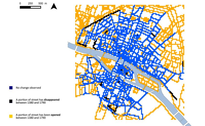
This study compared two maps of the city of Paris to study the evolution of the street network over the
long term. The first is a reconstitution of the late 14th century Parisian street network by the CNRS based on
written sources. The second is the Plan de Verniquet, engraved in 1791, and recognized for its high degree
of street precision. If we compare these maps via an analytic grid composed of 25×25 m squares, the result is
figure 1, focused on the 14th century city area. Each square is coloured depending on the presence or
absence of differences between the 14th and 18th centuries: blue if no change is observed, black if a part of a
medieval street disappeared, and yellow if a part of a street showed up in the late 18th century but did not
exist in the late 14th. A large majority of squares are blue (95% within the city walls), meaning that the major
part of the medieval network was still in existence in the late 18th century. We can thus conclude from
figure 1 that the Parisian street network was very stable between the 14th and 18th centuries.
Figure 1. Comparison of two maps (1380 and 1791) of the Parisian street network through an analysis grid
(squares of 25×25 m). © Léa Hermenault
2
This study has first been elaborated in the context of my archaeology thesis: “La ville en mouvements. Circulations, échanges
commerciaux et matérialité de la ville : pour une articulation systémique des facteurs d’évolution du tissu urbain parisien entre
th
le XVe et le XIXe siècle“, Paris 1 Panthéon-Sorbonne University. This thesis, defended on the 17 of April 2017, is available at this
address: https://halshs.archives-ouvertes.fr/tel-01551802
Archéologie, société et environnement / Archaeology, Society and Environment – vol. 2, n° 1
© 2021 ISTE OpenScience – Published by ISTE Ltd. London, UK – openscience.fr Page | 2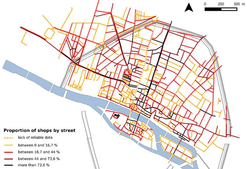
While the street network appears very stable, what about the occupations of people who were living along
them? Studying the location of trades in Paris over the long term is possible based on three documents. The
first, called les rôles de la taille, is a set of taxation registers studied by Caroline Bourlet (Bourlet & Layec,
2013). Seven of these registers remain from the reign of King Philippe Le Bel. They are dated between 1292
and 1313, but only that of 1300 is complete. The purpose of these registers changed through time. The 1300
register, for example, is linked to a certain commercial tax, called maltôte, which was considered particularly
restrictive and disadvantageous by Parisians. They managed to have it transformed into an annual payment
based on property assets, or on furniture for the poorest. The register from 1300 corresponds to the last of
these annual payments. It includes around 10,000 named taxpayers, their individual tax amount owed and,
for about 75% of the entries, the individual’s occupation. Each taxpayer can be precisely located within the
city because tax collection was carried out along a route which is described in the register. For all these
reasons, this taxation register holds a keen interest from a social-topography perspective (Bourlet & Layec,
2013). For the purposes of this paper, I will focus on three occupations: bakers, pasty makers and hotel
keepers. I have chosen these specific businesses because all of them are customer-flow dependent, and are
thus good markers of the most visited streets in 1300. Figure 2 shows the location of these types of
businesses across the city.

    Figure 2. Location of bakers, hotel keepers and pasty makers in Paris in 1300 (study of the tax register “rôle de la
     Taille”) – APUR © ALPAGE : Anne-Laure Bethe, Caroline Bourlet, Yoann Brault, Nicolas Faucherre, Davide
                                 Gherdevich, Hélène Noizet – Léa Hermenault, 2019

   I compared this data with the paving expenditures made by Paris merchants during the 15th century. At
the end of the 12th century, King Philippe Auguste ordered every street of the city to be paved at the
residents’ expense, with the exception of certain streets whose paving was to be funded by a community of
Paris merchants whose role was to organize and ensure trade in the city. These streets are very likely to have
been those whose viability was considered vital for the city’s supply of goods. They form what is called in

Archéologie, société et environnement / Archaeology, Society and Environment – vol. 2, n° 1
© 2021 ISTE OpenScience – Published by ISTE Ltd. London, UK – openscience.fr                                    Page | 3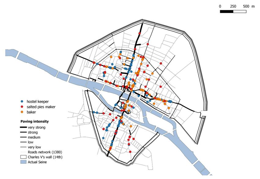
the documents since at least the 14th century la Croisée de Paris (the crossroads of Paris). The Croisée was
composed of 23 streets in 1400 and 74 in 1489, meaning that streets were added to the group over time. All
amounts paid by the merchant community for the paving or repaving of these streets were recorded each
year in the Compte du domaine de la ville, together with other expenditures and receipts. None of these
original account registers remain for the Middle Ages with the exception of 1488-1489, but copies of some
of them were made in the mid-18th century, before the destruction of the originals in the late 18th century.
Twenty-five years of copied account registers between 1424-1489 are kept in the National Archives
(registers published in Vidier et al., 1948 and Monicat, 1958). In total, 137 Parisian pounds were spent to
repave 418 toises during these 25 years. It is worth noting that most of the streets included in the Croisée de
Paris as of the 15th century were already part of it as of the early 14th century. We assume that the necessity
of repaving a street can be linked to the circulation of pedestrians, livestock and vehicles, and thus can be a
means of measuring human presence and use. If we compare data extracted from the tax register and paving
expenditures, we can see that the streets which were attractive for flow-dependent trades in 1300 are the
same as those most frequently repaved during the 15th century (figure 3). A brief study of the shopkeeper
map in the beginning of the 18th century, made thanks to the data extracted from the Terrier du Roi3, leads to
the conclusion that the most frequently repaved streets during the 15th century are among those still used
most frequently for shopping three centuries later (figure 4).

        Figure 3. Comparison of the distribution of bakers, hotel keepers and pasty makers in Paris in 1300 (study of the
    tax register “rôle de la Taille”) and of the repaving activities during the 15th century – APUR © ALPAGE : Anne-Laure
    Bethe, Caroline Bourlet, Yoann Brault, Nicolas Faucherre, Davide Gherdevich, Léa Hermenault, Hélène Noizet – Léa
                                                         Hermenault, 2019

3                                                                                      1      1-14
  The Terrier du roi is composed of several registers (Archives Nationales, Q *1099 ), which aimed to describe plots of Paris
(presence of shop, garden, buildings, etc.). Ordered in 1700, the project stopped in 1725 and remained uncomplete for the left
river bank of the city (Le Maresquier-Kesteloot, 2002).

Archéologie, société et environnement / Archaeology, Society and Environment – vol. 2, n° 1
© 2021 ISTE OpenScience – Published by ISTE Ltd. London, UK – openscience.fr                                         Page | 4
Figure 4. Proportion of parcels with shop(s) to total number of parcels in the beginning of the 18th century (study of
 the “Terrier du Roi”) – APUR © ALPAGE : Anne-Laure Bethe, Yoann Brault, Nicolas Faucherre, Davide Gherdevich,
                               Léa Hermenault, Hélène Noizet – Léa Hermenault, 2015

    At the city scale, we can thus witness the great stability of the Parisian street network and the continued
attractiveness of several specific streets for shopkeepers between the 14th and 18th centuries. However do
urban forms give the same impression of stability if we observe them on a larger scale?

3. Parcels and buildings evolve at a different pace

   It is very difficult to get a complete overview of the evolution of a building block over the long term
since, unfortunately, there are very few cities where archaeologists have managed to completely excavate an
entire block. To fill this gap, I chose to use land parcels as a reflection of how buildings were organised:
consolidating and splitting parcels and the evolution of circulation within city blocks can tell us much about
the evolution of the buildings themselves. In Paris, several land transaction or planimetric documents enable
us to follow the pace of evolution of land parcels over the long term, and therefore to deduce information
about the evolution of buildings. I focused on the Place Maubert, one of the liveliest neighbourhoods on the
left bank of the Seine river. Located at the foot of Montagne Sainte-Geneviève, Place Maubert received
flows of passers-by and customers coming from both gates of Saint-Victor and Bordelle, meaning all the
flows coming from the southeast of Paris. As proof of the high density of these flows, Place Maubert was
one of the very few places on the left bank whose paving expenses were charged to the merchants of Paris in
the late 15th century. Figure 5 presents the evolution of two buildings blocks located along the Place
Maubert between 1360 and 1460, known from work carried out by Anne Cauquetoux (Cauquetoux, 1986),
who studied land management documents from the Sainte-Geneviève Abbey, the main landholder of the

Archéologie, société et environnement / Archaeology, Society and Environment – vol. 2, n° 1
© 2021 ISTE OpenScience – Published by ISTE Ltd. London, UK – openscience.fr                                    Page | 5
area. She reconstructed parcels located around the Place Maubert in 1360 and 1460. If we compare these two
reconstitutions we note that several parcels were split along the Place Maubert and the Rue des Noyers (red),
and approximately 20 were consolidated along the side streets Rue des Lavandières and Rue des Anglais
(blue). The consequences of these changes upon circulation within the blocks are important: new easements
were created and some tenants took advantage of the consolidation of parcels to increase the number of
access points, for example obtaining one on the main street for customer purposes and another on a side
street to facilitate vehicle entry. These two reconstitutions clearly show that there were a multitude of
changes to parcel configurations between 1360 and 1460, and it is logical to assume that buildings must have
undergone numerous modifications.
Figure 5. Evolution of two building blocks during two time periods (5.A: 1360-1460 ; 5.B: 1730-1836).
© Léa Hermenault, d’après Anne Cauquetoux, 1986
The comparison of two more parcel representations shows the evolution of parcel limits during another
time period. The first of them is a local cadastral map likely drawn by Abbot Delagrive. Entitled Plan
détaillé de la place Maubert4, it is dated around 1730. The second are the oldest and most complete cadastral
4
Boutier, Sarazin and Sibille, 2007, pp. 277‑ 279 (Bibliothèque Nationale de France, RESERVE VE-53 (J)-FT 6) is available online:
http://catalogue.bnf.fr/ark:/12148/cb40312686w.public
Archéologie, société et environnement / Archaeology, Society and Environment – vol. 2, n° 1
© 2021 ISTE OpenScience – Published by ISTE Ltd. London, UK – openscience.fr Page | 6maps in existence for Paris. Called plans Vasserot, they were drawn by Philibert Vasserot and his colleagues
between 1810 and 18365. Figure 5 shows the evolution of the same two building blocks between 1730 and
1836. Numerous parcel consolidations can be observed along the Rue des Noyers, at the corner of Place
Maubert and Rue des Lavandières and in the northern sector of the block. Consolidations were at times part
of large developments in certain areas (eg. close to Rue des Anglais), but could also be more limited in scope
(eg. Rue des Noyers). Parcels were split in the southwest corner of the block edged by Rue des Noyers and
Rue des Anglais, but also around the tip of the block edged by Place Maubert and Rue des Noyers. In
addition, many main entrance gates had disappeared along Rue des Noyers and Place Maubert, while several
others opened along different streets. We can assume that much of a building block’s internal circulation was
altered due to the addition or removal of a main gate.
From figure 5 we may conclude that land parcels underwent a high degree of evolution during the two
periods studied. There is therefore a very high probability that the organisation of buildings was also
significantly modified during that time.
4. Stability versus speed: the contribution of “resilience”
Previous examples have shown how the urban fabric can significantly change at the micro scale over the
long term even if, in the identical time period, almost no changes can be observed at the macro scale. What
may at first appear to be a paradox is actually not. This is because buildings evolve at a different pace than
street networks, which may remain stable: every slight modification carried out on the scale of buildings
reinforces the limits of the street, and the street network is consistently strengthened because building
modifications are not taking place simultaneously.
I argue that the pace of building evolution, especially in the Quartier Maubert, is the consequence of the
attractiveness of streets over the long term. The crucial position of the Place Maubert crossroads in the
Parisian network explains its attractiveness for shopkeepers. Constant splitting and consolidation of parcels,
in addition to the fragmented characteristics of the latter, along the most travelled streets6 was surely the
result of the attractiveness of this neighbourhood, notably for shopkeepers.
In my view, the stability of the Parisian street network, as well as the stable functional orientation of
several roads, can be explained in part by the attractiveness of streets as spaces of commercial interactions:
because the streets remained particularly attractive for shopkeepers, they continued to locate their trades
there. Thus, the constant evolution of the buildings ensured the stability of the streets themselves7.
I would argue that the permanence of the network during late Medieval and Early Modern period is a
consequence of the resilience of a specific productive and commercial system: customers bought products
from shopkeepers, who most of the time were also the producers of such products. Under this system, the
streets were places of exchange. As long as commercial exchanges play out in the same way, streets have
higher chances of remaining stable, as do the trades practied there (see figure 6).
5
Georeferenced and vectorized to the ANR funded research program ALPAGE (AnaLyse diachronique de l’espace urbain
PArisien: approche GEomatique), led by Hélène Noizet. Data are available at this address: https://alpage.huma-num.fr/ (Noizet
et al., 2013).
6
This kind of pattern is typical of attractive areas (Boudon et al., 1977 : 61).
7
This kind of observation has already been made by archaeo-geographers in different contexts. For instance, Sandrine Robert
(see her article in this journal issue – Robert, 2021 – this issue) shows in what extent the stability of routes (macro scale) over the
longue durée in strongly linked to street network’s possibilities of transformations (micro scale).
Archéologie, société et environnement / Archaeology, Society and Environment – vol. 2, n° 1
© 2021 ISTE OpenScience – Published by ISTE Ltd. London, UK – openscience.fr Page | 7This productive and commercial system was resilient because each of its components was capable of
adaptation: the craftsman/shopkeeper for instance was able to develop his or her production according to
customers’ desires or fashion trends just by returning to their workshop located in the back of the shop. This
kind of cycle could be very short (days or weeks), but cycles grew increasingly longer once the productive
system began evolving and the place of production began moving further away from the place of sale. This
kind of change become increasingly frequent and notable in Paris from the 18th century with the so-called
“shopping revolution” (Blondé & Coquery, 2005), and then in the beginning of the 19th century with the
Industrial Revolution. The evolution of the productive and commercial system and its relation with the
evolution of the urban fabric could be the next step of this line of research.
Figure 6. Diagram of the productive and commercial system and its interactions with the urban fabric © Léa
Hermenault
5. Conclusion
In the first part of this paper I have shown how stable the Parisian street network remained between the
14 and 18th centuries and how constantly well-travelled and therefore attractive several specific streets
th
proved for shopkeepers in that period. However, it would be simplistic to conclude that the Parisian street
network was resilient over the long term, because the word resilience, as defined by C. S. Holling, describes
the evolution of a system, not of a unique structure. I conclude that the stability of the Parisian street network
nonetheless results from the resilience of a system.
A study conducted on the building scale helps us to understand more of this system. A two-period study
of a very lively Parisian neighbourhood demonstrated that parcels, and probably therefore also buildings, are
constantly subject to reorganisation. I have assumed that this dynamic is the sign of the attractiveness of
certain streets of this neighbourhood for residents and more specifically for shopkeepers: a crowded place is
attractive for merchants and, thanks to a high density of shops, also attractive for customers. They buy their
products from shopkeepers, who can easily adapt their goods or their production to customer demand. As
long as commercial exchanges proceed in this manner, streets have a higher probability of remaining stable
because they are the central location of such exchanges.
Thus, it’s partly because the productive and commercial system is resilient over the longue durée (that
means that it can absorb or withstand perturbations that occurred at micro scale) that the material structure of
Archéologie, société et environnement / Archaeology, Society and Environment – vol. 2, n° 1
© 2021 ISTE OpenScience – Published by ISTE Ltd. London, UK – openscience.fr Page | 8this system (street network, density of buildings) remains the same. Perturbations are therefore one condition
of this material structure’s stability. At a micro scale, we can also assume that some charasteritics of this
material structure (plots fragmentation for instance) are one condition of the occurrence of such numerous
perturbations. The evolution of the system once consumption patterns change is yet to be analysed.
Employing the concept of “resilience” according to the enriched definition proffered by C. S. Holling
allows for a better exploration of the social reality of past societies. Used in this manner, it shows to what
extent resilience is not only relevant to describing complex systems, but also a powerful heuristic tool.
REMARK. This text is published following its presentation at the session organized by the
commission Theory and methods in Landscape archeology - Archeogeography at the XVIIIth
Congress of the International Union of Prehistoric and Protohistoric Sciences (UISPP),
Tuesday, June 5, 2018 at the University Paris 1 Panthéon-Sorbonne. The UISPP, founded in
1931, is a member of the International Council for Philosophy and Humanistic Studies, and is
associated with UNESCO and the Academy (https://www.uispp.org/).
REMARQUE. Ce texte est publié suite à sa présentation à la session organisée par la commission
Theory and methods in Landscape archeology – Archeogeography lors du XVIIIe Congrès de
l’Union Internationale des Sciences Préhistoriques et Protohistoriques (UISPP), le mardi 5 juin
2018 à l’Université Paris 1 Panthéon-Sorbonne. L’UISPP, fondée en 1931, est membre du
Conseil International de philosophie et de Sciences humaines, et associée à l’UNESCO et à
l’Académie (https://www.uispp.org/).
Acknowledgements
I would like to express my gratitude to the UISPP and especially to the Landscape Commission led by
Sandrine Robert for having given me the occasion to present this paper during the XVIIIth Congress and to
publish it. I also would like to thanks Stéphanie Cooper-Slockyj for her revision of the English version of
this text.
Conflicts of interest
No conflict of interest to declare.
Evaluation
Reviewer for this paper is Michelle Elliott.
Peer-reviewer responsibilities
Reviewer evaluations are given serious consideration by the editors and authors in the preparation of
manuscripts for publication. Nonetheless, being named as a reviewer does not necessarily denote approval of
a manuscript; the editors of Archaeology, Society and Environment take full responsibility for final
acceptance and publication of an article.
Bibliographical references
Blondé, B., Coquery, N., 2005. Retailers and Consumer Changes in Early Modern Europe: England, France, Italy and
the Low Countries. Presses universitaires François-Rabelais, Tours, 259 p.
Boudon, F., Chastel, A., Couzy, H., Hamon, F., 1977. Système de l’architecture urbaine : le quartier des Halles à Paris.
Editions du Centre National de la Recherche Scientifique, Paris, 414 p.
Archéologie, société et environnement / Archaeology, Society and Environment – vol. 2, n° 1
© 2021 ISTE OpenScience – Published by ISTE Ltd. London, UK – openscience.fr Page | 9Bourlet, C., Layec, A., 2013. Densités de population et socio-topographie : la géolocalisation du rôle de taille de 1300, in : Noizet, H., Bove, B., Costa, L. (Eds), Paris, de parcelles en pixels. Presses universitaires de Vincennes et Comité d’histoire de Paris, Saint-Denis, Paris, 223-245. Boutier, J., Sarazin J-Y., Sibille, M. 2007. Les plans de Paris : des origines (1493) à la fin du XVIIIe siècle. Bibliothèque nationale de France, Paris, 430 p. Cauquetoux, A., 1986. Le quartier Maubert (place Maubert, rues Galande, des Noyers et des Anglais), aux XIV e et XVe siècle. Mémoire de maîtrise, Université Paris 4, Paris, 95 p. Clémençon, A-S, Noizet, R., sous presse (2021). Faire ville. Entre planifié et impensé, la fabrique ordinaire des formes urbaines. Presses universitaires de Vincennes, Saint-Denis, 464 p. Gunderson, L., H., Holling, C. S., 2002. Panarchy: Understanding Transformations in Systems of Humans and Nature. Island Press, Washington DC, 536 p. Hermenault, L., 2017. La ville en mouvements. Circulations, échanges commerciaux et matérialité de la ville : pour une articulation systémique des facteurs d’évolution du tissu urbain parisien entre le XV e et le XIXe siècle. Thèse de Doctorat, Université Paris 1 Panthéon-Sorbonne, Paris, 611 p. Holling, C. S., 1973. Resilience and stability of ecological systems. Annual Review of Ecology and Systematics. 4(1), 1-23. Le Maresquier-Kesteloot, Y-H., 2002. Le terrier du Roi pour la ville et faubourgs de Paris au début du XVIIIe siècle, in : Brunel, G., Guyotjeannin, O., Moriceau, J.-M. (Éds), Terriers et plans-terriers. Actes du colloque de Paris (23- 25 septembre 1998), Ecole nationale des Chartes, Paris, 133-150. Marchand, C., 2003. Des centuriations plus belles que jamais ? Etudes rurales. 167-168, 93-113. Monicat, J., 1958. Comptes du domaine de la Ville de Paris (1457-1489). Imprimerie Nationale, Paris, 699 p. Noizet, H., Bove, B., Costa, L., 2013. Paris, de parcelles en pixels. Presses universitaires de Vincennes et Comité d’histoire de Paris, Saint-Denis, Paris, 243 p. Resilience Alliance, 2019. Key Concepts. https://www.resalliance.org/key-concepts, visited on the 18th of November 2019. Robert, S., 2003. L’analyse morphologique des paysages entre archéologie, urbanisme et aménagement du territoire : exemples d’études de formes urbaines et rurales dans le Val-d’Oise. Thèse de Doctorat, Université Paris 1 Panthéon-Sorbonne, Paris, 1391 p. Robert, S., 2021. Applying the concept of panarchy in archaeogeography: the example of resilience of routes in the “longue durée”. Archéologie, société et environnement. 2(1), ce volume. Robert, S., sous presse. La résilience : persistance et changement dans les formes du paysage. ISTE, Londres, 286 p. Vidier, A., Le Grand, L., Dupieux, P., 1948. Comptes du domaine de la Ville de Paris (1424-1456). Imprimerie Nationale, Paris, 1055 p. Walker, B., Holling C. S., Carpenter, S. R., Kinzig, A., 2004. Adaptability and Transformability in Social-Ecological Systems. Ecology and Society. 9(2), 5. Archéologie, société et environnement / Archaeology, Society and Environment – vol. 2, n° 1 © 2021 ISTE OpenScience – Published by ISTE Ltd. London, UK – openscience.fr Page | 10
Vous pouvez aussi lire