User Guide September 2021 - MINISTÈRE DES FORÊTS, DE LA FAUNE ET DES PARCS
←
→
Transcription du contenu de la page
Si votre navigateur ne rend pas la page correctement, lisez s'il vous plaît le contenu de la page ci-dessous

User Guide
September 2021

MINISTÈRE DES FORÊTS, DE LA FAUNE ET DES PARCS

Forêt ouverte: User Guide

Authors
Mélanie Major, ing. f., M. Sc., Direction des inventaires forestiers, MFFP
Jean Mercier, tech. f., Direction des inventaires forestiers, MFFP
Louise Noreau, préposée aux renseignements, Direction des inventaires forestiers, MFFP

Coordination
Isabelle Legault, ing. f., M. Sc., Direction des inventaires forestiers, MFFP

Layout
Geneviève Barry, technicienne en administration, Direction des inventaires forestiers, MFFP

Translation and linguistic revision
Anne Theodorescu, ing. f., Direction des inventaires forestiers, MFFP
Karine Flamand, Direction des communications, MFFP
Laurence Carignan, Direction des communications, MFFP

Distribution
Ministère des Forêts, de la Faune et des Parcs
Direction des inventaires forestiers
5700, 4e Avenue Ouest, A-108
Québec (Québec) G1H 6R1
Telephone : 418 627-8669
Toll-free : 1 877 936-7387
Fax: 418 646-1995
inventaires.forestiers@mffp.gouv.qc.ca
mffp.gouv.qc.ca

© Gouvernement du Québec
Ministère des Forêts, de la Faune et des Parcs
Legal deposit - Bibliothèque et Archives nationales du Québec, 2020
ISBN (PDF) : 978-2-550-86889-7 (2nd edition, September 2021)
ISBN (PDF) : 978-2-550-86366-3 (1st edition, March 2020)
Forêt ouverte: User Guide

Table of Contents
Introduction ......................................................................................................................................1
Interactive Tours...............................................................................................................................2
Main Menu Features ........................................................................................................................4

        Help ..........................................................................................................................................5

     Search Results.............................................................................................................................6
   Search by Wood Lot Number .......................................................................................................7
   Find a SNRC mapsheet..................................................................................................................8
   Personalize Search Results ...........................................................................................................9
   Pointer Position Options ........................................................................................................... 10
   Search by Coordinates ............................................................................................................... 11
View the coordinates of a Point .................................................................................................... 12

     GPS Location ............................................................................................................................ 12

       Map........................................................................................................................................ 13
Layer Display Options .................................................................................................................... 14
   Filter the Layers in the Map Feature ......................................................................................... 15
   Legend Options .......................................................................................................................... 16
   Descriptive Table of Layer Features .......................................................................................... 18
   Map Project Example ................................................................................................................ 20

     Time Filter ................................................................................................................................ 21

     Attribute filter ......................................................................................................................... 24
Layer Display Scale and Zoom ....................................................................................................... 25
Data Imprint .................................................................................................................................. 26
Downscaled Resolutions of LiDAR Products and Satellite Mosaics ............................................... 26

      Map Themes ........................................................................................................................... 27

     Catalog ..................................................................................................................................... 28

      Measure ................................................................................................................................. 30

      Draw ....................................................................................................................................... 31

     Import and Export ................................................................................................................... 32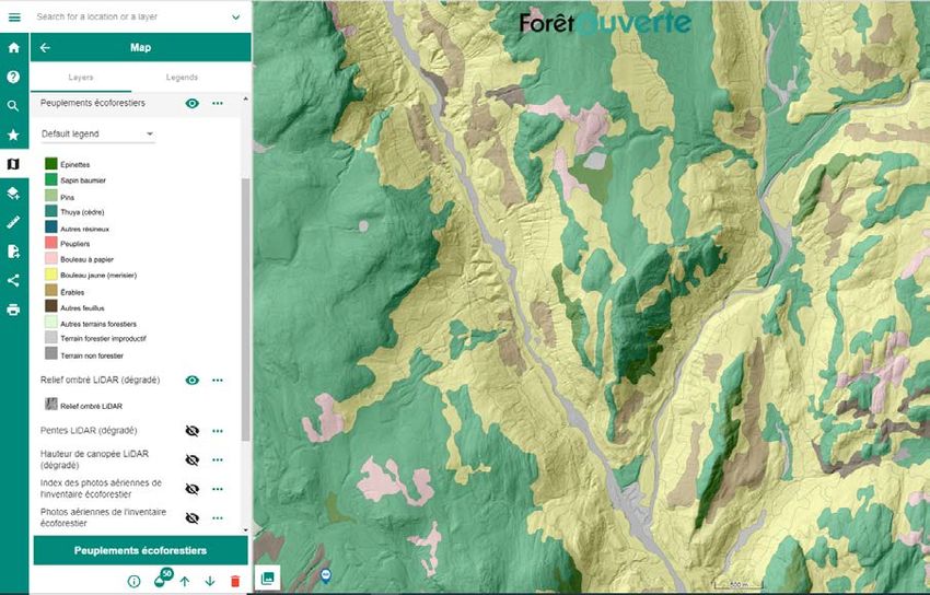
Forêt ouverte: User Guide

       Share ...................................................................................................................................... 34

        Print ...................................................................................................................................... 35
Download ...................................................................................................................................... 36
Appendix 1: List of Different Catalog Layers and Defined Display Scales ..................................... 42
Appendix 2: Value of Grouped Fields in Legends of Certain Layers .............................................. 48
   Peuplements écoforestiers........................................................................................................ 48
   Récolte et reboisement ............................................................................................................. 49
   Infrastructures en milieu forestier ............................................................................................ 49
User’s Guide to Forêt ouverte
Introduction
In 2017, the ministère des Forêts, de la Faune et des Parcs (MFFP) committed to offering free and
up-to-date data to its external clients. This openness is part of Québec’s commitment to be an
open government, with the objective of promoting transparency and accessibility to data. The
interactive Web map of ecoforest data of the Direction des inventaires forestiers (DIF) facilitates
access to free data and makes it possible to explore this data without having to use specialized
geomatics software.
The interactive Web map of ecoforest data produced by the DIF has, since April 2019, become
Forêt ouverte. This new name better represents the interactive map’s content.
In April 2020, the Web map service of the “Subdivisions territoriales forestières (STF)” was added
to Forêt ouverte following a partnership with the Direction de la gestion intégrée de l’information
et des orientations (DGIIO). In July 2021, wildlife data were added to Forêt ouverte following a
distribution agreement with the Faune sector of the MFFP.
Forêt ouverte is supported by the 2nd version of the Open GIS Infrastructure (IGO2), an open
geomatics Web solution which respects open international standards. IGO2 was recognised as the
first open geomatics Web solution of Québec’s public administration. Based on collaborative
developpement, IGO2 is contantly improved for the benefit of its users. A new version already
exists as of December 2019, allowing for an improved visual experience, and the addition of new
functions was made regularly throughout 2020 and 2021.
To access Forêt ouverte :
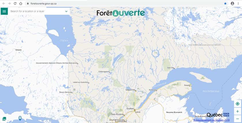
https://www.foretouverte.gouv.qc.ca
Click on the image below to access a short tutorial which will help you understand the basics of
the interactive map and greatly improve your first use of Forêt ouverte.
Ministère des Forêts, de la Faune et des Parcs 1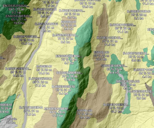
User’s Guide to Forêt ouverte

Interactive Tours
An interactive tour of Forêt ouverte is available to quickly discover the different features of the
interactive map. Access the interactive tour via 1) the welcome window, 2) the shortcut button
found in the main menu or 3) the “Help” tab.

                         1

                                                 2                                              3

Ministère des Forêts, de la Faune et des Parcs                                                  2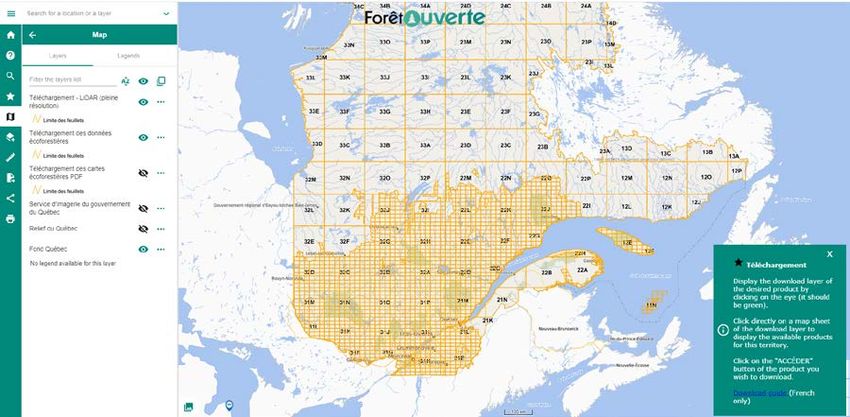
User’s Guide to Forêt ouverte

New : Specific interactive tours are also available for the “Measure” and “Import and export”
features.

Ministère des Forêts, de la Faune et des Parcs                                            3
User’s Guide to Forêt ouverte

Main Menu Features
Click on the Main Menu icon in the upper left corner of the interactive map to access all of the
menu’s features.

Ministère des Forêts, de la Faune et des Parcs                                                 4
User’s Guide to Forêt ouverte

       Help
A brief description of all the features of the interactive map is found in the Help section as well as
a link to : 1) several tutorials, 2) Forêt ouverte’s User Guide, 3), the Download section and its user
guide, 4) the Web Map Services (WMS) list and its user guide, 5) the Direction des inventaires
forestiers (DIF) email for any questions or comments and finally, 6) a link to a satisfaction survey
to help us improve Forêt ouverte.

      1

      2
                                3

                                    4
                                                 6

      5

Ministère des Forêts, de la Faune et des Parcs                                                     5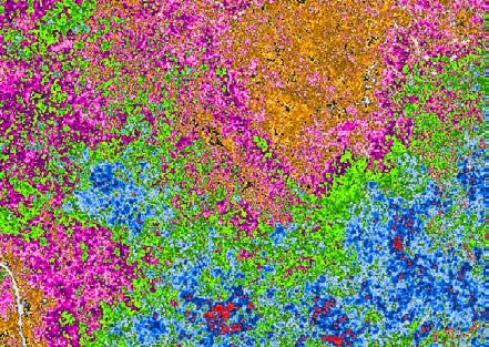
User’s Guide to Forêt ouverte

     Search Results
In the top left corner of the interface is the Search bar which allows you to search for an address,
a location, a lot number (new), or GPS coordinates. This tool can also be used to search for a
specific layer.

Search for a location or a layer

First, type the location or name of a layer in the Search bar, for example, “Québec”. The search
results are displayed underneath.

Different icons are used to distinguish the type of search results (e.g., a city, a lake, a mountain),
found via the “iCherche” search engine or a layer. Click on “Display more results” if you do not
see what you are looking for.

To cancel a search, click on the x. This also removes the blue selection that appears when clicking
on one of the search results.

Ministère des Forêts, de la Faune et des Parcs                                                     6
User’s Guide to Forêt ouverte In order to add a layer to the map from the search results, click the + beside the layer name. The icon changes into a red garbage can to show that the layer has been added to the map. A small grey eye above the red garbage can indicates that the current display scale is too small to see the layer. Simply zoom in and the layer will appear. Click on the Map feature to see the display options, or visit the Layer Display Scale and Zoom section of this guide. Search by Wood Lot Number Type the wood lot number in the Search bar, for example the number “5 471 380”. Click on the result found under the category “Cadastre”. Ministère des Forêts, de la Faune et des Parcs 7
User’s Guide to Forêt ouverte

Find a SNRC mapsheet
New: it is now possible to search for a specific 1/250 000 or 1/50 000 SNRC mapsheet.

Ministère des Forêts, de la Faune et des Parcs                                          8
User’s Guide to Forêt ouverte

Personalize Search Results
You can personalize your search results by clicking on the arrow on the right of the Search bar
and selecting the desired type and quantity of results. For example, you can 1) select the type of
results you want for the “iCherche” search engine; 2) select the number of results shown for the
layers; 3) search a lot number (new); 4) select the search radius for the search by coordinates or
deactivate the mapsheet search option (not illustrated).

                           1

                                                                                            3

                           2

                                                             4

Ministère des Forêts, de la Faune et des Parcs                                                  9
User’s Guide to Forêt ouverte Pointer Position Options An option is available to activate a tooltip showing the mouse pointer coordinates. Click on the arrow on the right of the Search bar and slide the Pointer position button to the right. When activated, the coordinates of the mouse pointer as well as the other location properties that are selected in the Result types of the Search by coordinates option appear near the mouse pointer. Tip: Use the F2 key to activate/deactivate the pointer position option. Ministère des Forêts, de la Faune et des Parcs 10
User’s Guide to Forêt ouverte

Search by Coordinates
The search bar can also be used to locate specific coordinates on the map, either by using a
decimal degrees format, in a geographical WGS 84 projection (EPSG : 4326) (e.g., 47.001835, -
71.317186), or a degrees, minutes, seconds format (e.g., 47°00'06.6"N 71°19'01.9"W).

Ministère des Forêts, de la Faune et des Parcs                                           11
User’s Guide to Forêt ouverte

View the coordinates of a Point
In order to identify the coordinates of a desired point on the map, right click on the desired point
and choose Show coordinates. The coordinates will appear in the Main Menu window. The
selected point can also be displayed in Google Maps or Google Street View.

Tip: Copy the coordinates of a point for later use by coordinate search. It is also possible to save
     the display scale through map sharing. Consult the Share section of this guide for more
     information.

     GPS Location
It is possible to find your current location using the GPS location tool found at the bottom right
of the screen. This option allows you to center the map on your current location.

Ministère des Forêts, de la Faune et des Parcs                                                  12
User’s Guide to Forêt ouverte
Map
The Map feature is the heart of Forêt ouverte. This feature allows you to display the list of layers
added to the map, view their legends, access their display options, remove them from the map as
well as download them. Layers can be added to the Map feature using the Catalog, the Search
bar or by choosing a theme in the Map themes feature.
By default, the Map feature comprises the following layers: “Lieux habités”, “Chemins”, "Courbes
de niveau”, “Index des photos aériennes de l’inventaire écoforestier”, “Photos aériennes de
l’inventaire écoforestier”, “Mosaïque Sentinel 2019”, “Mosaïque Landsat 2019”, “Service
d’imagerie du gouvernement du Québec”, “Relief du Québec” and the “Fond Québec” basemap.
By default, the basemap is the only visible layer . To make the other layers visible, click on the
(the eye becomes green).
A shortcut at the bottom left of the screen allows you to quickly switch between
the basemaps available in the chosen Map theme.
Ministère des Forêts, de la Faune et des Parcs 13User’s Guide to Forêt ouverte
Layer Display Options
1 3 4
1. Layer name
2. Display or hide the legend 1 by clicking on
the name of the layer. When the layer
is visible (green eye), the legend is 2
visible by default.
3. Display or hide the layer. The layer is
visible when the eye is green.
4. Additional options for the layer
When you click on the “…”, a window appears
below the list of layers, showing the options
available for this layer.
5. Consult the Données Québec data factsheet
6. Change the transparency of the layer
7. Change the order of the layers
Note: It is not possible to move a layer
defined as a basemap layer.
8. Remove the layer from the Map
Note: It is not possible to move a layer
defined as a basemap layer.
5 6 7 8
1
The values of grouped fields for the legends of certain layers can be found in Appendix 2.
Ministère des Forêts, de la Faune et des Parcs 14User’s Guide to Forêt ouverte
Filter the Layers in the Map Feature
9. Search for layers within the Map
10. Sort the layers in alphabetical order
9 10 11 12
11. Show only the visible (green eye) layers
12. Activate the multiple selection mode
The multiple selection mode can be used to apply layer options to
multiple layers at once: change the transparency, the order or the
visibility of the layers or remove multiple layers. Simply click on
the square that appears to the left of the layer’s name when the
mode is activated to select the desired layers.
Ministère des Forêts, de la Faune et des Parcs 15User’s Guide to Forêt ouverte Legend Options Certain layers have several legend options. You can choose the legend option that best corresponds to your needs. By default, the legend appears when the layer is active (green eye). Click on the name of the layer to display its legend if it is hidden. Click on the name of the layer to hide the legend if needed. Click on the arrow to the right of the legend to access the drop-down menu with the available legend options. Ministère des Forêts, de la Faune et des Parcs 16
User’s Guide to Forêt ouverte

You can now choose between the “Layers” and “Legends” tabs above the list of layers in the Map
feature. The “Layers” tab is where you can see all of the layer options, whereas the “Legends” tab
shows only the legends of active layers (green eye).

Ministère des Forêts, de la Faune et des Parcs                                                17
User’s Guide to Forêt ouverte

Descriptive Table of Layer Features
It is possible to obtain additional information on a layer’s attributes when this information is
available. Simply click on the desired feature of a layer to open its descriptive table. For example,
if you are viewing the “Peuplements écoforestiers” layer and you click on a forest stand, a new
window will appear presenting a detailed description of that stand. The         icon at the top left of
the table allows you to select different zoom options for the chosen element. The “Zoom on
feature” function allows to adjust the map scale to the selected feature. A shortcut to this option
is available in the table’s header. Activating the “Zoom auto” function will automatically zoom on
elements as soon as they are selected.

Ministère des Forêts, de la Faune et des Parcs                                                     18
User’s Guide to Forêt ouverte

When several layers overlap, it is necessary to select the     icon next to the desired layer, in this
case the “Peuplements écoforestiers” layer, in order to open the descriptive table associated to
the selected stand. It is also possible to consult the attributes of the overlapping layers by using
the arrows found at the top right and left of the table title, or by returning to the list of entities
found on the map by clicking on the the        icon found at the top left of the table and then on
“Return to list”. The “Zoom on all features” function adjusts the map scale to show all of the
selected features.

Ministère des Forêts, de la Faune et des Parcs                                                    19
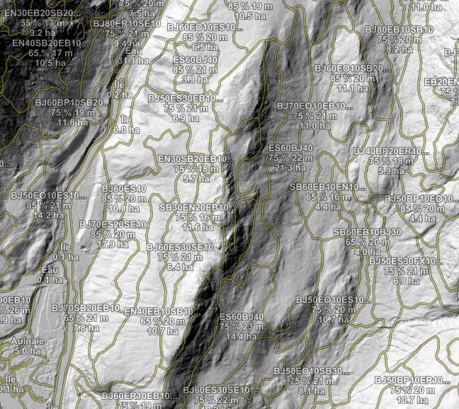
User’s Guide to Forêt ouverte

Map Project Example
The “Peuplement écoforestier” layer with 50% transparency overlapping the “Relief ombré
LiDAR” layer. Legend options are shown with color and labels, or simply with contours and
labels.

Legend: “Couleur avec étiquette”                 Legend: “Contour avec étiquette”

Ministère des Forêts, de la Faune et des Parcs                                              20
User’s Guide to Forêt ouverte

    Time Filter
The Time filter feature allows you to define a time lapse on the layer you wish to display. This
feature is only available for certain layers (layers with a ). The four main layers which can be
filtered are grouped in the “Perturbations de la forêt” Map theme. The “Chasse” Map theme also
contains a layer that can be filtered.

Perturbations de la forêt                            Chasse

To access the time filter, click on the … next to the layer, such as next to the “Feux de forêt” layer.
A new window appears below the list of layers.

Ministère des Forêts, de la Faune et des Parcs                                                     21
User’s Guide to Forêt ouverte Click on the time filter icon in this window and then choose the desired time lapse, such as the forest fires that occurred between 2000 and 2007. A red number appears indicating that a filter is applied to the layer. Map without a time filter Map with a time filter Tip: To visualize different types of disturbances that occur during non-consecutive years, it is possible to see the annual layers available in the “Données écoforestières (DIF)“ Catalog. Consult the Catalog section in this guide for more information. Ministère des Forêts, de la Faune et des Parcs 22
User’s Guide to Forêt ouverte

The time filter can be accessed in the main menu features for the “Perturbations de la forêt” and
“Chasse” Map themes. This option makes it possible to view all the layers that can be filtered
within the same window. The layer legends can also be visualised within this window, by simply
clicking on the layer name if the legend is hidden.

Ministère des Forêts, de la Faune et des Parcs                                               23
User’s Guide to Forêt ouverte

     Attribute filter
New: The attribute filter allows you to select, using buttons, the elements to be displayed in a
layer based on certain attribute values. For now, the filter is only available for the "Peuplements
écoforestiers" layer. Click on the … to the right of the layer name to open the layer options
window. Click on the filter icon, then on the different buttons to filter the layer. In the example
below, the layer will only show conifer stands that are 17-22 metres tall.

Map without a filter                             Map with a filter

Ministère des Forêts, de la Faune et des Parcs                                                 24
User’s Guide to Forêt ouverte Layer Display Scale and Zoom Certain layers, such as the “Peuplements écoforestiers” layer are too heavy to display on a provincial scale. To remedy this situation, display scales are set for certain layers. The display parameters for these layers can be found in Appendix 1. A grey eye next to a layer indicates that the latter cannot be viewed in the active scale (the value of the active scale is found at the bottom of the map). To view the layer, simply zoom closer to or, in some cases, further away from the layer. To zoom in or out, you can use the buttons at the bottom right of the screen or scroll using the mouse (in the case of a desktop computer). Tip: A keyboard shortcut exists to zoom in or out using a square selection. Simply hold the SHIFT key while clicking the left mouse button and drawing a rectangle over the desired area. Ministère des Forêts, de la Faune et des Parcs 25
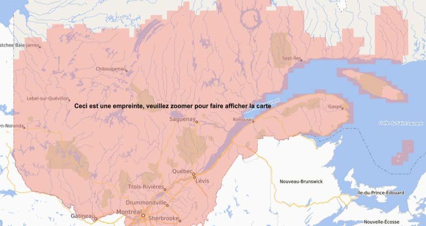
User’s Guide to Forêt ouverte

Data Imprint
For certain layers, a salmon-colored imprint appears to show the areas where the data is available.
Simply zoom in to the active view scale to view the content of the layer.

Downscaled Resolutions of LiDAR Products and Satellite Mosaics
In order to optimize the display of the LiDAR derivative products (“MNT” [DTM], “Relief ombré”
[Shaded Relief], “Hauteur de canopé” [Canopy height] and “Pentes” [Slopes]) as well as the
Satellite Image Mosaics, the resolution of these layers has been sligthly downscaled. To view these
layers at full resolution, simply download them (view the Download section of this guide) and add
them to a GIS (e.g. Arcmap).

Full Resolution Canopy Height Model              Downscaled Resolution Canopy Height Model

Ministère des Forêts, de la Faune et des Parcs                                                 26
User’s Guide to Forêt ouverte

     Map Themes
The Map themes feature allows for the quick display of layers grouped under different themes.
The use of Map themes is a key concept that is central to the effective use of Forêt ouverte.

When you choose a theme from Map themes, the layers associated to this theme are added to
the Map. The layers found by default in the Map are those found under the theme “À construire”.
Depending on your interest, you may begin a project with the default map theme or choose
another one. Then, to add layers to your map, you can browse the Catalog or use the Search bar.

WARNING: When you choose another theme in the Map theme feature, all layers found in the
Map feature will be replaced by those of the new theme. Therefore, you will lose all the layers
previously added through the Catalog or the Search bar. Before changing your Map theme, share
your map!

LiDAR Map theme example: All four LiDAR derivative products, their download index layer and
the maps showing their planned availability, as well as the index showing the acquisition years of
LiDAR data and the planification map for the availability of the LiDAR dendrometric map, are
found in the “LiDAR” Map theme. When you choose the “LiDAR” theme, these layers are added
to the Map.

Ministère des Forêts, de la Faune et des Parcs                                                27
User’s Guide to Forêt ouverte
Catalog
The Catalog contains all the layers that can be added to the Map feature. Click on the + to the
right of the layer to add the latter to the Map. The + then becomes a red garbage can, which
allows you to remove the layer if desired. It is possible to add an entire group of layers using the
+ next to the group name.
For example, to add the “Peuplements écoforestiers” layer to the Map, select the Catalog and
click on “Données écoforestières 2”. Then click on the arrow next to “Peuplements écoforestiers”
to see all the layers within this group.
2
Refer to Appendix 1 for a complete list of layers found in the different catalogs.
Ministère des Forêts, de la Faune et des Parcs 28User’s Guide to Forêt ouverte Click on the + to the right of the « Peuplements écoforestiers » layer. The + becomes a red garbage can and the layer is now available in the Map feature and visible in the map. It is possible to preview a layer by simply positionning the cursor over the + beside a layer, without clicking on it. However, if there is a small grey eye above the +, the current map scale does not allow the preview. Ministère des Forêts, de la Faune et des Parcs 29
User’s Guide to Forêt ouverte

      Measure
It is possible to measure different lengths (1) and areas (2) on your map using the Measure tool.
Once the measure tool is activated (activated by default) (3), simply click on the map. It is possible
to measure several segments. Double click to end the segments and add up their distances. Each
segment has a length label if this option is activated (4) and the total distance is found in the
“length” bar (5). Also, previously measured lengths are found at the bottom of the window (6)
and it is possible to delete them by clicking on the garbage can (7).

To measure an area, select this option (2) and form a polygon in the map, double clicking to close
the shape. The area and perimeter are calculated in the associated bar (8). It is possible to change
the units (9) for both area and length measures.

                            1                    2

                                             3

                                             4

                        5
                                                 9
                        8

                        7

                        6

Ministère des Forêts, de la Faune et des Parcs                                                    30
User’s Guide to Forêt ouverte
Draw
New: The Draw tool allows you to add 1) points, lines, polygons and circles to the map. Simply
click on the map when the drawing tool is activated (activated by default) (2). When creating a
new entity, 3) the tool offers to assign a label to it. It is then possible to 4) hide the labels in the
map. The color of the 5) fill and the 6) contour of the entities can be changed, however this choice
affects all drawings for now. Finally, it is possible to 7) select each drawing and delete it if
necessary.
1 3
2
4
5
6
7
When you create a drawing, a "Drawings"
layer is added in the list of layers in the
"Map" tab. The layer can be exported using
the "Import and Export" tab. A shortcut to
the export feature is also available in the
layer’s options. See the "Import and export"
section of this guide for more details.
Ministère des Forêts, de la Faune et des Parcs 31User’s Guide to Forêt ouverte
Import and Export
The import and export feature applies to a layer or a personalized map. To import a layer, choose
1) the “Layer” tab, 2) the “Import” tab, 3) the coordinate system of the file you wish to import
and 4) click on the “Import” button. To import a layer in a shapefile format, it is important that
the layer be in a .zip file. Refer to the .PRJ file of your shapefile if needed.
Note: The size limit for importing a file varies depending on the format (GeoJSON, GML, GPX, KML,
Shapefile). For larger files, use the GeoJSON format.
The export layer feature is possible only for Web Feature Service (WFS) layers. As the majority of
Forêt ouverte’s layers are in WMS format for now, very few layers can be exported at the moment.
However, the “Drawings” layer created by the Draw tool can be exported. Select 5) the “Layer”
tab, then 6) the “Export” tab. The “Drawings” layer is selected by default for export (7). Next,
8) choose a file format (GeoJSON, GML, GPX, KML, Shapefile, CSV (comma delimited) et CSV
(semicolon delimited) and 9) click on “Export”. A new file will be created in your computer’s
“Downloads” folder.
1
2 5
6
3
7
4
8
9
Ministère des Forêts, de la Faune et des Parcs 32User’s Guide to Forêt ouverte
It is also possible to export a personalized map, for example a map theme to which layers have
been added. To export a map, simply 1) select the “Map” tab, 2) then select the “Export” tab,
3) choose a title for the map, 4) select the layers you wish to add to the exported map and 5) click
on the “Export” button. The export tool will create a .JSON file in your computer’s “Downloads”
folder. This feature, as opposed to the “Share” feature, does not maintain the zoom of the
exported map, but does save the list of layers for future use.
To import a map, select 6) the “Map” tab, then 7) the “Import” tab and 8) click on “Import”. Select
a .JSON file that you have previously exported. Your map will be added to the list of map themes
and its layers will appear in the “Map” feature.
1 6
7
2
3 8
4
5
Ministère des Forêts, de la Faune et des Parcs 33User’s Guide to Forêt ouverte
Share
The Share option creates a hyperlink (URL) of your map that redirects you to an exact
representation of what you see on your screen. It is possible to copy this link in a document or
email and share it with someone or refer to it for later use.
Ministère des Forêts, de la Faune et des Parcs 34User’s Guide to Forêt ouverte
Print
It is possible to print the map viewed on screen using the Print option. It is possible to add a title
and a short description of the map, choose the output format (PDF or image [PNG, BMP, GIF or
Tiff]), the page size (A0 through A5, letter or legal) and the desired layout (landscape or portrait).
It is also possible to show the projection, the scale and the legend of the map in the printed
document.
Note: The display of the legends in printed maps should be improved in later versions of Forêt
ouverte. Also, it is not yet possible to obtain a georeferenced map usable offline, but seeing as
this feature is in high demand, it will also be evaluated for the following versions of Forêt ouverte.
Ministère des Forêts, de la Faune et des Parcs 35User’s Guide to Forêt ouverte
Download
The Forêt ouverte interface offers two ways to downlaod the data for free.
1. The first way consists in choosing the Map theme “Téléchargement”. You will then find
in the Map feature three download index layers: “Téléchargement – LiDAR (pleine
resolution)”, “Téléchargement des données écoforestières”, and “Téléchargement des
cartes écoforestières PDF”. Note that these layers can also be added to the Map feature
using the Catalog or Search bar.
Two indexes with map sheets scaled at 1/20 000 for the PDF and LiDAR products and one index
with map sheets scaled at 1/250 000 for other ecoforest data are used to locate the territories for
which you wish to download data.
Ministère des Forêts, de la Faune et des Parcs 36User’s Guide to Forêt ouverte When you click in a map sheet associated to the index layer of the desired data, for example the 32A map sheet of the “Téléchargement des données écoforestières” index layer, a table will appear with a list of available products to download for this map sheet. Click on the button to download the product of your choice. You will then be re- directed to an FTP site where you can choose the desired folder to download. Ministère des Forêts, de la Faune et des Parcs 37
User’s Guide to Forêt ouverte

Note: The numbers 10 and 93 in the ZIP folder names refer to versions of ArcMap. Use the 93
folder if you are using the 9.3 version, and use the 10 folder if you are using versions 10 and up.

It is also possible to download more than one map sheet by clicking on the [parent directory] link.
You can then copy the FTP address in a Windows explorer window or use the free software
FileZilla, and copy and paste all the folders of interest. Consult the following document for more
details (only available in French): “Téléchargement de données – méthode rapide de
téléchargement”.

Ministère des Forêts, de la Faune et des Parcs                                                 38
User’s Guide to Forêt ouverte

Ministère des Forêts, de la Faune et des Parcs   39
User’s Guide to Forêt ouverte

     2. The second way to download data is to click on the       of the desired layer in the Map
        feature. This button acts as a link to Données Québec’s data sheet where you can access
        different types of downloadable data (.shp, .csv, .gdb, etc.) as well as complementary
        documents (metadata, normative files, indexes, etc.).

Ministère des Forêts, de la Faune et des Parcs                                              40
User’s Guide to Forêt ouverte It is possible to access the available data by clicking on the “Download” button of the Access the data directory in the “Data & Resources” section of the Données Québec’s data sheet. The data is generally presented by map sheet and therefore you must know in which map sheet you wish to find your data. It is also possible to download several map sheets at once by copying the FTP address in a Windows explorer window or by using the free Filezilla software. Consult the following document for more details (only available in French): « Téléchargement de données – méthode rapide de téléchargement ». Ministère des Forêts, de la Faune et des Parcs 41
User’s Guide to Forêt ouverte

Appendix 1: List of Different Catalog Layers and Defined Display Scales
(Maximum scale value that allows display. Example:                 )

 Catalogues, groupes et couches                                   Contour    Étiquette
 Découpages territoriaux
 Découpages administratifs
    • Agglomération                                                    -        -
    • Communauté métropolitaine                                        -      20 km
    • Arrondissement                                                   -      20 km
    • Municipalité                                                     -        -
    • Municipalité régionale de comté                                  -        -
    • Région administrative                                            -        -
 Découpages cartographiques
    • Fuseaux MTM                                                      -        -
    • Fuseaux UTM                                                      -        -
    • Feuillets 1/20 000                                               -      20 km
 Données écoforestières
 Index et téléchargement
     • Téléchargement cartes écoforestières PDF                        -       5 km
     • Téléchargement données écoforestières                           -         -
     • Disponibilité de la carte écoforestière du 5e inventaire        -         -
 Peuplements écoforestiers
     • Peuplements écoforestiers                                   2 km     200 – 500 m
 Volumes forestiers
     • Volumes marchands bruts (7 m et +)                          2 km     200 – 500 m
 Dépôts de surface
     • Dépôts de surface de la carte écoforestière
 Pentes
     • Pentes numériques                                          1000 m    200 – 500 m
 Perturbations naturelles et anthropiques
     • Feux de forêt                                              50 km       50 km
     • Épidémies, chablis et verglas                               2 km       500 m
     • Infrastructures en milieu forestier                         2 km         -
     • Récolte et reboisement                                      2 km       500 m
     • Récolte et reboisement récents (après 1999)                 2 km       500 m

Ministère des Forêts, de la Faune et des Parcs                                        42
User’s Guide to Forêt ouverte
Données écoforestières (suite)
Récolte et reboisement annuels
• Récolte et reboisement anciens (avant 1976) 2 km 500 m
• Récolte et reboisement 1976 2 km 500 m
• … 1977 à 2017 2 km 500 m
• Récolte et reboisement 2018 2 km 500 m
Feux de forêt annuels
• Feux de forêt anciens (avant 1976) 50 km 50 km
• Feux de forêt 1976 50 km 50 km
• … 1977 à 2018 50 km 50 km
• Feux de forêt 2019 50 km 50 km
Épidémies, chablis et verglas annuels
• Épidémies, chablis et verglas anciens (avant 1976) 2 km 500 m
• Épidémies, chablis et verglas 1976 2 km 500 m
• … 1977 à 2018 2 km 500 m
• Épidémies, chablis et verglas 2019 2 km 500 m
Infrastructures en milieu forestier annuelles
• Infrastructures en milieu forestier 2003 2 km 500 m
• … 2004 à 2018 2 km 500 m
• Infrastructures en milieu forestier 2019 2 km 500 m
Productivité potentielle par essence
• Hauteur potentielle à 50 ans (m) :
2 km 200 – 500 m
EPN, EPB, EPR, SAB, PIB, PIG, BOP, PET, THO
• Accroissement potentiel (cm2/ti/an) :
2 km 200 – 500 m
ERS, BOJ, ERR
Propriétés du bois par essence
• EPN, densité (kg/m3) 2 km 200 – 500 m
• SAB, densité (kg/m3) 2 km 200 – 500 m
• EPN, rigidité (GPa) 2 km 200 – 500 m
• SAB, rigidité (GPa) 2 km 200 – 500 m
Contraintes à l’aménagement forestier
• Contrainte de sol mince 2 km -
• Contrainte de solidité du sol 2 km -
• Contrainte de rugosité 2 km -
• Contrainte d’orniérage 2 km -
• Contrainte d’érosion du sol 2 km -
• Contrainte d’appauvrissement des sols par la récolte 2 km -
Ministère des Forêts, de la Faune et des Parcs 43User’s Guide to Forêt ouverte
Données écoforestières (suite)
Classification écologique du territoire québécois
• Étages de végétation
• Districts écologiques - 20 km
• Unités de paysage régional - -
• Sous-régions écologiques - -
• Régions écologiques - -
• Sous-domaines bioclimatiques - -
• Domaines bioclimatiques - -
• Sous-zones de végétation - -
• Zones de végétation - -
Hydrographie forestière
• Hydrographie surfacique forestière
Couches écoforestières du Nord québécois
• Végétation du Nord québécois 2 km 1000 m
• Dépôts de surface du Nord québécois 5 km 1000 m
• Photographies obliques - -
Sondage terrestre
• Placettes temporaires 2e inventaire 50 km -
• Placettes temporaires 3e inventaire 50 km -
• Placettes temporaires 4e inventaire 50 km -
• Placettes temporaires 5e inventaire 50 km -
• Points d’observation écologique
Données Québec
Catalogue non décrit
Données fauniques
Gestion de la faune et des habitats
• Chasse interdite
• Habitats fauniques
• Sous-zone de chasse
• Territoires fauniques structurés
• Unités de gestion des animaux à fourure
Protection de la faune
• Bureau de la Protection de la faune du Québec
• Directions régionales de la Protection de la faune
Ministère des Forêts, de la Faune et des Parcs 44User’s Guide to Forêt ouverte
Subdivisions territoriales forestières
Conservation de la biodiversité
• Écosystème forestier exceptionnel 5 km 2 km
• Écosystèmes forestiers exceptionnels - Point - -
• Parcs nationaux du Québec (désignés et projetés) - 10 km
• Projet de refuge biologique 5 km 5 km
• Refuge biologique désigné 5 km 5 km
• Refuges biologiques - Point - -
Limites et territoires forestiers du domaine public
• Aire d’intensification de la production ligneuse - 5 km
• Bureau UG - 50 km
• Certification forestière 200 km -
• Forêt d’enseignement et de recherche 5 km 2 km
• Forêt d’enseignement et de recherche – Point - -
• Forêt d’expérimentation 5 km 2 km
• Forêt d’expérimentation – Point - -
• Limite territoriale des forêts attribuables - -
• Région de garantie d’approvisionnement (1/1 000 000) - 50 km
• Région de garantie d’approvisionnement (1/20 000) 2 km 2 km
• Unité d’aménagement (1/1 000 000) - -
• Unité d’aménagement (1/20 000) 2 km 2 km
• Unité de gestion (1/1 000 000) - -
• Unité de gestion (1/20 000) 2 km 2 km
• Zone de tarification - 50 km
Limites territoriales forestières du domaine privé
• Agence de mise en valeur des forêts privées - 25 km
(1/1 000 000)
• Agence de mise en valeur des forêts privées (1/20 000) 100 km
• Groupement forestier (1/1 000 000) -
• Groupement forestier (1/20 000) 100 km 25 km
• Propriété privée - 2,5 km
• Syndicat et office de producteurs de bois (1/1 000 000) - 25 km
• Syndicat et office de producteurs de bois (1/20 000) 100 km
Subdivisions territoriales forestières amalgamées
• Aires protégées 10 km 5 km
• Autres terrains publics 10 km 2 km
• Forêt de proximité – FP 10 km 5 km
• Forêt d’enseignement et de recherche 10 km 5 km
• Forêt d’expérimentation – FE 10 km 5 km
Ministère des Forêts, de la Faune et des Parcs 45User’s Guide to Forêt ouverte
Subdivisions territoriales forestières (suite)
• Lacs et rivières importantes 10 km -
• Pépinière publique forestière – PPU 10 km 5 km
• Station forestière Duchesnay 10 km 2 km
• Terres privées 10 km 5 km
• Territoires autochtones 10 km 5 km
• Territoires forestiers résiduels – TFR 10 km -
• Unité aménagement – UA 10 km 5 km
Terrain forestier par domanialité
• Forêt privée (1/1 000 000) 20 km -
• Forêt privée (1/20 000) 2 km -
• Forêt publique fédérale (1/1 000 000) 20 km -
• Forêt publique fédérale (1/20 000) 2 km -
• Forêt publique provinciale (1/1 000 000) 20 km -
• Forêt publique provinciale (1/20 000) 2 km -
Territoires forestiers publics sous droits consentis
• Convention de gestion territoriale – CGT 50 km -
• Entente de délégation – ED 50 km -
• Forêt d’enseignement et de recherche – FER 50 km -
• Garantie d’approvisionnement – GA 50 km -
• Permis de récolte pour approvisionnement d’usine – 50 km -
PRAU
• Permis de récolte pour approvisionnement d’usine de 50 km -
biomasse – PRBIO
• Station forestière 50 km -
• Terres de catégorie 50 km -
Imagerie aérienne et satellitaire
Téléchargement – mosaïques d’images satellites
• Téléchargement de données écoforestières - -
Mosaïques d’images satellites
• Mosaïques Landsat (1986, 2011 à 2020) - -
• Mosaïque Sentinel (2018 à 2020) - -
Photos aériennes de l’inventaire écoforestier
• Index des photos aériennes de l’inventaire écoforestier - -
• Photos aériennes de l’inventaire écoforestier - -
Imagerie aéroportée forsetière historique
• Ce groupe inclut de nombreuses couches, classées par
année, par projet, par résolution et par type d’image
Ministère des Forêts, de la Faune et des Parcs 46User’s Guide to Forêt ouverte
Informations géominière (SIGEOM)
Catalogue non décrit
LiDAR
Index et téléchargement
• Téléchargement – LiDAR (pleine résolution) - 10 km
• Téléchargement – Carte dendrométrique LiDAR
• Années d’acquisition du LiDAR - -
• Disponibilité des produits dérivés du LiDAR - -
• Disponibilité de la carte dendrométrique LiDAR
Produits dérivés du LiDAR
• Hauteur de canopée LiDAR (dégradé) 50 km – 50 m -
• Modèle numérique de terrain LiDAR (dégradé) 50 km -
• Relief ombré LiDAR (dégradé) 50 km -
• Pentes LiDAR (dégradé) 50 km -
Produits dérivés hydrographiques issus du LiDAR
• Lits d’écoulement potentiels LiDAR
• Indice d’humidité topographie LiDAR (dégradé)
Couches de base (non disponibles dans le catalogue)
• Lieux habités - -
• Chemins -
• Courbes de niveau 1000 m 200 – 500 m
• Service d’imagerie du gouvernement du Québec - -
• Relief du Québec - -
• Fond Québec - -
Ministère des Forêts, de la Faune et des Parcs 47User’s Guide to Forêt ouverte
Appendix 2: Value of Grouped Fields in Legends of Certain Layers
Peuplements écoforestiers
Épinettes EB, EN, EP, EU, EV, RE, EE, EF, EM
Sapin SB, SE, SC, SS, SF, SM, SP
baumier
Pins PB, PG, PI, PR, PS, PC
Thuya TO, CE
(cèdre)
Autres ME, MH,MJ, ML, MR, PU, RB, RF, RM, RP, RS,
résineux RX, RZ,
Peupliers PA, PD,PE,PH,PO,PT
Bouleau à BB,BG, ,BP
papier
Bouleau BJ
jaune
Érables EA,EI,EO,ER,ES
Autres FH, FI, FN, FX, FZ, MF, , FO, FP, FR FT, CC, NN,
feuillus OA, OR, TA, FA, HG, CB, CH, CR
Autres PL, CPI_RL_F, CPPTM_U, CPHRS, CPPTM_DIS,
terrains CPRS_BA, BR, CBA, CBT, CDV, CEF, CHT, CPE,
forestiers CPH, CPR, CPT, CRB, CRR, CRS, CT, DT, ENS, ETR,
P, PLR, PRR, REA, RPS, VER, RIA, CPR_U-F,
CPRS_U, RECUP_C-T
Terrain AL, DH, DS, IMP
forestier
improductif
Terrain non A, AF, ANT, AEP, AER, AUT, BAS, BAT, BHE, CAM,
forestier CAR, CFO, CHE, CS, CU, DEF, DEM, DEP, ESG, FRI,
GOL, GR, HAB, INC, INO, LTE, MI, MX, NF, NX,
QUA, RO, TNP, TOE, US, VIL, VRG, RRG, ENR, DL,
EPC_SYS, CP, EL, BRP, ENP, CHP
Ministère des Forêts, de la Faune et des Parcs 48User’s Guide to Forêt ouverte
Récolte et reboisement
Mode de CON, ENM, ENR, ENP, ENS, , P,
régénération PLB, PLN, PLR, PRR, RIA, RR, RRG,
RRN, RRP, RRR, REA, FR
Éclaircie et DEG, DRC, DRM, , EPC, EPR
dégagement
Coupe partielle CA, CAM, CB, CBT, CD, CDL, CE,
CEA, CIP, CJ, CJP, CJT, CJG, CP,
CPI, CPS, CPF, CPM, CPC, CTR, EC,
ECE, ECL, ESI, PCP, PSP, PTA
Coupe avec CPE, CPH, CPR, CPT, CDV, CRS,
protection de la CEF, CRB, CS, CBA, CIF, CT, DLD,
régénération ETR, CRR, RBV, RPS
Infrastructures en milieu forestier
Aire d’empilement et AEP
d’ébranchage
Camp forestier CFO
Dépotoir DEP
Gravière GR
Ligne de transport d’énergie LTE
Milieu perturbé par NF, ANT
l’activité humaine
Terrain agricole AF, A
Emprise de chemin RO
Ministère des Forêts, de la Faune et des Parcs 49User’s Guide to Forêt ouverte Ministère des Forêts, de la Faune et des Parcs 50
Vous pouvez aussi lire