A century of village mobilities and landscape dynamics in a forest-savannah mosaic of the Democratic Republic of Congo
←
→
Transcription du contenu de la page
Si votre navigateur ne rend pas la page correctement, lisez s'il vous plaît le contenu de la page ci-dessous
Bois et Forêts des Tropiques – ISSN : L-0006-579X
                                                                                                             Volume 348 – 2e trimestre – juin 2021 – p. 3-16
                                                                  DYNAMIQUES VILLAGEOISES ET PAYSAGÈRES DANS UNE MOSAÏQUE FORÊT-SAVANE / LE POINT SUR…          3

        Christophe Demichelis1
        Johan Oszwald2                                       A century of village mobilities
                                                                and landscape dynamics
        Arthur Bostvironnois1
        Clélia Gasquet-Blanchard1, 3
        Victor Narat4, 5
        Jean-Christophe Bokika6
        Tamara Giles-Vernick4                               in a forest-savannah mosaic of
        1
         Université de Rennes 2
                                                           the Democratic Republic of Congo
        Laboratoire ESO, UMR CNRS 6590
        35 place du Recteur Henri Le Moal
        35000 Rennes - France

        2
         Université de Rennes 2
        Laboratoire LETG-COSTEL,
        UMR CNRS 6554
        35 place du Recteur Henri Le Moal
        35000 Rennes - France

        3
         École des hautes études en santé
        publique
        5 avenue du Professeur Léon Bernard
        35043 Rennes - France

        4
         Institut Pasteur
        Unité d’anthropologie et écologie
        de l’émergence des maladies
        25-28 rue du Dr Roux
        75015 Paris - France

        5
         CNRS/MNHN/Université de Paris
        UMR 7206 Éco-anthropologie
        17 place du Trocadéro
        75016 Paris - France

        6
         ONG Mbou-Mon-Tour
        Ferme pilote à 1 km de Nkala
        Territoire de Bolobo
        République démocratique du Congo

        Auteur correspondant /                                          Photo 1.
        Corresponding author:                                           Wet herbaceous savannah with a forest patch in the background,
        Christophe DEMICHELIS –                                         characteristic landscape of the study area.
                                                                        Photo C. Demichelis.
        christophe.demichelis@gmail.com

Doi : 10.19182/bft2021.348.a31934 – Droit d’auteur © 2021, Bois et Forêts des Tropiques – © Cirad – Date de soumission : 28 octobre 2020 ;
date d’acceptation : 25 janvier 2021 ; date de publication : 18 juin 2021.

                                                                                Citer l’article / To cite the article
                                                                                Demichelis C., Oszwald J., Bostvironnois A., Gasquet-Blanchard C., Narat
                                                                                V., Bokika J.-C., Giles-Vernick T., 2021. A century of village mobilities and
                    Licence Creative Commons :                                  landscape dynamics in a forest-savannah mosaic, Democratic Republic
                    Attribution - 4.0 International.                            of Congo. Bois et Forêts des Tropiques, 348 : 3-16. Doi : https://doi.
                    Attribution-4.0 International (CC BY 4.0)                   org/10.19182/bft2021.348.a31934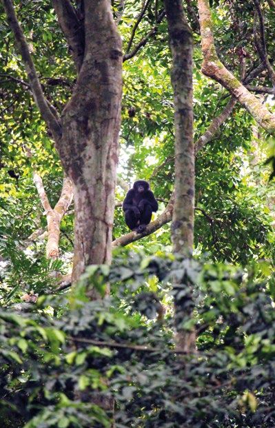
Bois et Forêts des Tropiques – ISSN: L-0006-579X
    Volume 348 – 2nd quarter - June 2021 - p. 3-16
4   FOCUS / VILLAGE AND LANDSCAPE DYNAMICS IN FOREST-SAVANNAH MOSAIC                                           C. Demichelis, J. Oszwald, A. Bostvironnois,
                                                                                                               C. Gasquet-Blanchard, V. Narat, J.-C. Bokika,
                                                                                                               T. Giles-Vernick

                          RÉSUMÉ                                          ABSTRACT                                           RESUMEN
          Effets d’un siècle de mobilité villageoise         A century of village mobility                     Un siglo de movilidad de los pueblos
          sur la dynamique paysagère                         and landscape dynamics                            y la dinámica del paisaje
          d’une mosaïque forêt-savane                        in a forest-savannah mosaic                       en un mosaico de bosque y sabana
          en République démocratique du Congo                of the Democratic Republic of Congo               de la República Democrática del Congo

          Sur les lisières de la forêt du Bassin du          Along the edges of the Congo basin forest,        A lo largo de las lindes del bosque de la cuenca
          Congo, où les mosaïques de forêt et de             where forest-savannah mosaics are the main        del Congo, donde los mosaicos bosque-sabana
          savane dominent les formations écolo-              ecological formation, it is important to deter-   son la principal formación ecológica, es impor-
          giques, il est important de connaître le mode      mine how this mosaic has developed, parti-        tante determinar cómo se ha desarrollado este
          d’évolution de ces mosaïques, notamment            cularly for forest protection. Have savannah      mosaico, especialmente para la protección del
          pour mieux protéger la forêt. Les savanes          lands resulted from deforestation or have         bosque. ¿Las tierras de la sabana son el resul-
          sont-elles le résultat de la déforestation, ou     forest patches expanded into them? Given          tado de la deforestación o los rodales de bos-
          ont-elles été envahies par des îlots fores-        the long-standing human occupation of this        que se han expandido en ellas? Dada la larga
          tiers ? Compte tenu de l’ancienneté de l’oc-       region, this question needs to be addressed       ocupación humana de esta región, esta cues-
          cupation humaine dans cette région, cette          through human-environment relationships           tión debe abordarse a través de las relaciones
          question doit être abordée par le biais des        over time. Combining oral histories of vil-       entre el hombre y el medio ambiente a lo largo
          relations humaines avec l’environnement au         lage mobility and geographical analyses of a      del tiempo. La combinación de relatos orales
          cours du temps. Le rapprochement entre les         forest-savannah mosaic in the Bolobo terri-       sobre la movilidad de los pueblos y los análisis
          histoires orales sur la mobilité villageoise       tory (Democratic Republic of Congo) can shed      geográficos de un mosaico de bosque y sabana
          et l’analyse géographique d’une mosaïque           light on the landscape dynamics. This study       en el territorio de Bolobo (República Democrá-
          forêt-savane en territoire Bolobo (RDC) ren-       involved nine months of daily participant         tica del Congo) puede arrojar luz sobre la diná-
          seigne sur la dynamique paysagère de la            observations of human land use practices,         mica del paisaje. Este estudio incluyó nueve
          région. La présente étude s’est basée sur          40 individual interviews and 18 focus groups      meses de observaciones participativas diarias
          neuf mois d’observation participative quoti-       to analyse changing village mobility from the     de las prácticas en el uso del suelo, 40 entre-
          dienne des pratiques d’utilisation des sols,       late 19th century to the present. Several maps    vistas individuales y 18 grupos de discusión
          40 entretiens individuels et 18 groupes de         were produced by combining oral histories         para analizar la evolución de la movilidad de
          réflexion mis en place pour analyser l’évo-        of past village mobility with an evaluation of    los pueblos desde finales del siglo XIX hasta la
          lution de la mobilité villageoise de la fin du     44 GPS landmarks corresponding to former          actualidad. Se elaboraron varios mapas combi-
          19e siècle à nos jours. Plusieurs cartes ont été   villages. Two Principal Component Analyses        nando los relatos orales sobre la movilidad de
          produites en intégrant les histoires orales sur    (PCA), based on landscape composition wit-        los pueblos en el pasado con una evaluación
          la mobilité villageoise passée et l’évaluation     hin a 250 m-radius buffer zone around the         de 44 puntos de referencia GPS correspon-
          de 44 repères GPS correspondant à d’anciens        GPS landmarks, according to a land cover          dientes a antiguos pueblos. Se utilizaron dos
          villages. Deux analyses en composante prin-        map classifying the landscape into 11 catego-     análisis de componentes principales (ACP),
          cipale (ACP) sur la composition paysagère          ries, were used to document forest expansion      basados en la composición del paisaje dentro
          d’une zone tampon dans un rayon de 250 m           into old abandoned villages and the effect of     de una zona tampón de 250 m de radio alrede-
          autour des repères GPS, selon une carte du         distance from currently inhabited villages.       dor de los puntos de referencia GPS, según un
          couvert terrestre qui distingue 11 catégories      Forest cover expanded into the abandoned          mapa de cobertura del suelo que clasificaba el
          paysagères, ont permis de documenter l’en-         villages and the savannah as a consequence        paisaje en once categorías, para documentar la
          vahissement d’anciens villages abandonnés          of environmental eutrophication facilitating      expansión del bosque hacia antiguos pueblos
          par la forêt et l’effet de la distance depuis      forest establishment. Forest use decreases        abandonados y el efecto de la distancia a los
          les villages actuels. Le couvert forestier s’est   with distance from currently inhabited vil-       pueblos actualmente habitados. La cubierta
          étendu dans les villages abandonnés et dans        lages as a result of a shift from semi-seden-     forestal se expandió en los pueblos abando-
          la savane en conséquence d’une eutrophi-           tary livelihoods in small settlements to enti-    nados y en la sabana como consecuencia de
          sation environnementale favorisant l’instal-       rely sedentary livelihoods in larger, extended    la eutrofización del medio ambiente, que faci-
          lation de la forêt. L’exploitation forestière      villages. Livelihood transformations that took    litó el establecimiento del bosque. El uso de
          décroît à mesure que l’on s’éloigne des vil-       place during and after colonisation resulted      los bosques disminuye con la distancia de los
          lages actuels en raison de la transition d’un      in a decline in the quality of environmental      pueblos actualmente habitados como resul-
          mode d’existence semi-sédentaire dans des          goods and reduced the well-being of human         tado de un cambio de los medios de subsis-
          petits hameaux vers une existence entière-         populations. These insights can help NGO          tencia semisedentarios en los asentamientos
          ment sédentaire dans des village étendus           conservation and development efforts to be        pequeños a los medios de subsistencia total-
          plus grands. Les transformations des modes         more sensitive to overlooked local human          mente sedentarios en las poblaciones más
          d’existence pendant et après la colonisation       practices and needs.                              grandes y extensas. Las transformaciones de
          ont provoqué un déclin de la qualité des                                                             los medios de subsistencia que se produjeron
          biens environnementaux et du bien-être des         Keywords: Belgian colonisation,                   durante y después de la colonización dieron
          populations humaines. Ces constats peuvent                                                           lugar a una disminución de la calidad de los
          contribuer à une meilleure sensibilisation sur     ecosystem services, livelihood changes,           bienes ambientales y redujeron el bienestar
          des pratiques et des besoins parfois mécon-        sedentarisation, forest expansion, geo-           de las poblaciones humanas. Estas observa-
          nus dans les efforts des ONG pour la conser-       historical analyses, Congo basin, Democratic      ciones pueden hacer que las ONG dedicadas
          vation et le développement.                        Republic of Congo, Africa.                        a la conservación y el desarrollo aumenten su
                                                                                                               sensibilidad hacia las prácticas y necesidades
          Mots-clés : colonisation belge, services                                                             humanas locales, que a menudo se omiten.
          écosystémiques, changements des moyens
          d’existence, sédentarisation, expansion                                                              Palabras clave: colonización belga, servicios
          forestière, analyses géo-historiques, Bassin                                                         ecosistémicos, cambios en los medios de
          du Congo, République démocratique du                                                                 subsistencia, sedentarización, expansión
          Congo, Afrique.                                                                                      forestal, análisis geohistóricos, cuenca del
                                                                                                               Congo, República Democrática del Congo,
                                                                                                               África.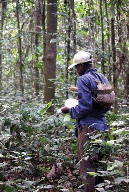
Bois et Forêts des Tropiques – ISSN : L-0006-579X
Volume 348 – 2e trimestre – juin 2021 – p. 3-16
DYNAMIQUES VILLAGEOISES ET PAYSAGÈRES DANS UNE MOSAÏQUE FORÊT-SAVANE / LE POINT SUR… 5
Introduction understand these landscape dynamics beyond the period
for which we have remote sensing imagery, it is necessary to
mobilise historical evidence and analysis. Hence, this study
Deforestation within the Congo basin forest has uses oral testimonies of those who experienced changes
emerged as a major concern in previous decades, resul- that span Belgian colonisation from the late 19th century
ting in the implementation of wide-ranging approaches to through the postcolonial period from 1960, or who heard
conserve landscapes, ecosystems, or ecosystem goods about such transformations from their parents. These tes-
and services (Lambin et al., 2003; Lambin and Meyfroidt, timonies are coupled with Global Positioning System land-
2011; Clay, 2016; Windey and Van Hecken, 2019). Studies marks from abandoned and currently occupied villages,
of deforestation, however, frequently focus on large-scale physical description and uses of these sites, as well as sta-
land cover, but do not consider changing land uses (Duveil- tistical and geomatic analyses, in order to demonstrate how
ler et al., 2008; Vittek et al., 2014). Although these macro- village mobilities have shaped land use and land cover. A
scale studies do not address land use, they nevertheless socio-ecological system (SES) approach was adopted, inte-
tend to attribute anthropogenic changes as explanations grating social and ecological features that shape a landscape
for deforestation, highlight the effects of agriculture, wood (Redman et al., 2004; Liu et al., 2007; Ostrom, 2009). This
extraction and livestock breeding, accelerated by technolo- SES incorporates a rigorous exploration of land use and land
gical developments, economic expansion and demographic cover changes with historical and anthropological analyses
pressure (Gillet et al., 2016). To better understand Congo of subjectivities embedded in landscape – “a form of codifi-
forest-edge dynamics and to integrate more fully human cation of history itself, seen from the viewpoints of personal
action into these dynamics, local, smaller scale approaches expression and experience” (Stewart and Strathern, 2003).
are needed.
Heterogeneous forest patch landscapes in Africa have
long been considered “degraded” and “deforested” ones
(Fairhead and Leach, 1996). Whether forest-savannah
mosaics are the result of deforestation or of forest expansion
into savannahs is well worth exploring, particularly in light of
the current need to protect forest cover and to regulate local
climates (Alkama and Cescatti, 2016). Local-scale studies
are most appropriate for gaining insight into interactions
between anthropogenic activities and forest cover.
With some notable exceptions (Kaplan et al., 2016),
forest dynamics tend to be studied over short periods,
comparing satellite images over a few years or decades
(Mayaux et al., 2003; Ciza et al., 2015). Yet in locations
where local populations have long relied heavily on natural
resources for their livelihoods, understanding forest cover
dynamics requires a longer time-frame of investigation than
a few decades, especially because of the long-term eco-
nomic and political processes that have transformed land
governance systems.
This type of long-term investigation requires the use of
other kinds of evidence than remote sensing alone, which
only offers quality data from the 1970s. In fact, there is evi-
dence that changing population settlement and expansion
in a given area over time is linked to the dynamics and trans-
formation of the landscape, including deforestation (Cour-
tin and Guengant, 2011). But the reverse is also true: the
landscape, and the associated environmental and sanitary
conditions, can be responsible for human mobility, espe-
cially in a context of climate change, including migration
(Van der Geest et al., 2010; Tankou et al., 2014) and displa-
cement (Gemenne et al., 2017).
The present study examines how village mobility has
affected the structure and dynamics of landscape change
in the North Batéké Chiefdom, located on the Congo basin
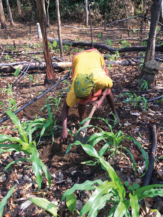
forest edge of the Democratic Republic of Congo (DRC). To Photo 2.
A woman cultivating maize on the site of the former village Ndzuomi
bonkolo (see figure 5), near the current village of Bodzuna.
Photo C. Demichelis.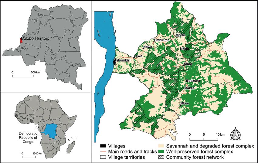
Bois et Forêts des Tropiques – ISSN: L-0006-579X
    Volume 348 – 2nd quarter - June 2021 - p. 3-16
6   FOCUS / VILLAGE AND LANDSCAPE DYNAMICS IN FOREST-SAVANNAH MOSAIC

                    The term “mobility” is used rather than migration
              because it includes “large-scale movements of people,                       Material and methods
              objects, capital and information across the world, as well as
              the more local processes of daily transportation, movement                               Study site
              through public space and the travel of material things within
              everyday life (Van Dijk et al., 2001; Hannam et al., 2006).     Geography and environment
              This study focused on village mobilities, rather than indivi-         The study was conducted in the North Batéké Chief-
              dual mobilities, in order to trace the potential impacts that   dom of the Maï-Ndombe Province (DRC), situated in
              human settlements could have on land use and land cover.        forest-savannah mosaic at the edge of the Congo Basin
                    The authors argue that in this zone on the Congo basin    forest (Pennec et al., 2016). Located less than 300 km from
              forest edge, past village migrations undertaken by Batio        the capital Kinshasa, the region supplies agricultural and
              peoples have contributed to forest expansion, rather than       forest food and other resources for the capital. The region
              engaging in forest cover destruction. At the same time,         is peopled primarily by Batio speakers (also referred to as
              contemporary sedentarization of these inhabitants has           Batéké in Lingala). This population lives primarily through
              encouraged intensified exploitation of ecosystem services,      farming and hunting, as well as fishing, gathering, and ani-
              raising questions about the longer-term sustainability of       mal husbandry.
              their agricultural activities.                                        The study site itself was defined by the boundaries of
                    By studying the past relations between village mobi-      traditional village territories where the local nongovernmen-
              lity and landscape evolution since the beginning of colonial    tal organization, Mbou-Mon-Tour (MMT), operates (figure 1).
              rule, this article seeks to understand current human sett-      Since the early 2000s, MMT has managed a community
              lement, land use and landscape dynamics. In a globalized        forest network to protect bonobo (Pan paniscus) popula-
              world where decisions are taken without considering local       tions and encourage sustainable economic development for
              realities, and facing climate change requiring urgent adap-     people living in the region (Narat et al., 2015a). In the mid-
              tation of rural populations, our approach can contribute to     2000s, the World Wide Fund for Nature (WWF) also under-
              more appropriate and effective integrated conservation and      took bonobo conservation in the region. Both MMT and WWF
              development interventions, by documenting changing local        are involved in land management and have implemented
              land uses and land cover.                                       new natural resource exploitation patterns.

          Figure 1.
          Study site (North Batéké Chiefdom, Democratic Republic of Congo).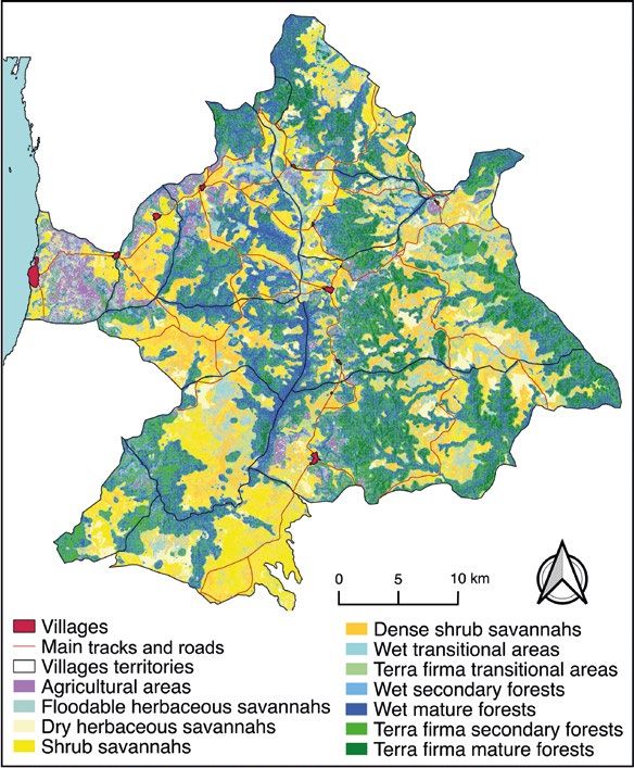
Bois et Forêts des Tropiques – ISSN : L-0006-579X
                                                                                                   Volume 348 – 2e trimestre – juin 2021 – p. 3-16
                                                          DYNAMIQUES VILLAGEOISES ET PAYSAGÈRES DANS UNE MOSAÏQUE FORÊT-SAVANE / LE POINT SUR…       7

History and economy                                                 (Arthur, 1991; Achberger, 2013). These colonial develop-
        The present study addresses the relationship between        ments and institutions initiated new settlement patterns
localized human mobility, land use, and land cover over             and new kinds of mobility. Moreover, these new mobility
the past century. This mobility and shifting land use have          patterns here as elsewhere in central Africa seem to have
been embedded in a longer-term dynamic of movement                  contributed to expansion and transmission of sleeping
and environmental exploitation, linked to processes of the          sickness, to which the Belgian colonial state responded
region’s integration into a global capitalist economy. Brie-        through multiple measures, including mobility controls on
fly, this region was deeply involved in a dynamic riverine          local population (Coquéry-Vidrovitch, 1972; Harms, 1981;
trade in ivory and slaves in the 19th century, bringing wealth      Lyons, 1994).
and political authority to local traders. Belgian colonization            The country’s postcolonial history has been well docu-
of Congo, however, effectively destroyed its importance             mented, but generally, early independence was beset by
(Harms, 1981). Following Henry Morton Stanley’s travels             substantial political and economic instability and conside-
through the Congo basin in 1877, Belgian commercial inte-           rable international intervention (Moreau, 2010; De Witte,
rests (notably the Belgian King Leopold’s International Afri-       2017; Kent, 2017). Under Mobutu Sese Seko, private enter-
can Association) spearheaded a series of treaties with local        prises were nationalised, but encouraged a “kleptocracy”,
rulers to initiate trade in ivory; subsequently, this part of the   in which Mobutu and his allies extracted wealth from these
Congo basin experienced an influx of European commercial            enterprises for personal gain (Moreau, 2010; Bobineau,
interests, which decimated locally-controlled trade. Euro-          2016). Heavily supported by European countries and the
pean incursions also catalysed violent conflicts with regio-        United States, Mobutu managed to hold power for multiple
nal inhabitants who sought to safeguard their control of the        more than two decades, but external support for his rule cru-
trade. Such conflicts resulted in violent reprisals, resulting      mbled rapidly following the fall of the Soviet Union in 1989.
in mass out-migrations into French-controlled territories           He held power 1997, but his rapacious extraction of wealth
(Vansina, 1973; Harms, 1981). Although elsewhere in the             had profoundly negative consequences for the country as a
central Congo Basin, Leopold’s concessionary company, the           whole. Nonetheless, during this postcolonial period, the site
Congo Independent State, had asserted initiated a brutally          in which the present study was conducted did experience
exploitative system of rubber extraction and coerced local          fleeting moments of economic expansion, notably in the
populations to harvest rubber, the Tshumbiri and Bolobo             1970s with the expansion of family-cultivated coffee pro-
regions appear to have been less affected by this “red rub-         duction, and in the late 1990s-early 2000s, with the implan-
ber” regime because they fled to French-controlled territo-         tation of the MMT and WWF conservation NGOs.
ries (Harms, 1981).
By 1909, new local
trading         patterns
developed based
on fishing, manioc
cultivation, and by
1920, poultry and
goat raising, linking
mobile            traders
from the inland
f o r e s t- sa va n na h
mosaic with rive-
rine trade networks
(Harms, 1981).
        The 20th cen-
tury brought addi-
tional changes to
this region of the
Belgian Congo. The
colonial         consoli-
dation of scattered
populations          into
larger villages, cen-
suses, and colonial
road construction,
as well as missio-
nisation and school          a                                                     b
construction          fol-
lowed during sub-
                                   Photo 3.
sequent decades
                                 Bonobo observed in the Bodzuna community forest (a), and Mbou-Mon-Tour tracker taking observation
                                 notes (b) as part of the habituation, conservation and local development program.
                                 Photo C. Demichelis.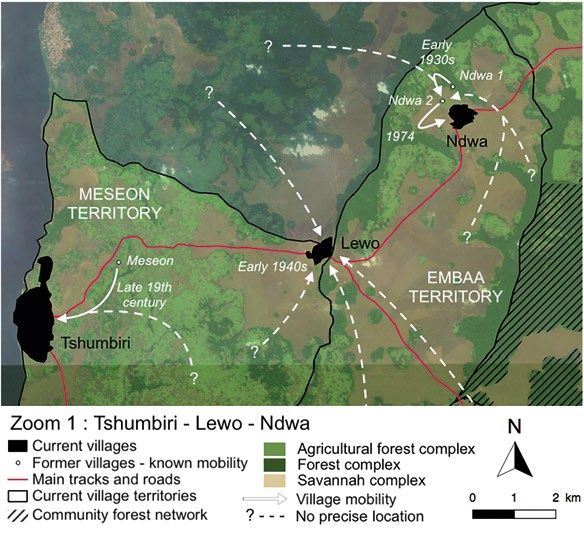
Bois et Forêts des Tropiques – ISSN: L-0006-579X
    Volume 348 – 2nd quarter - June 2021 - p. 3-16
8   FOCUS / VILLAGE AND LANDSCAPE DYNAMICS IN FOREST-SAVANNAH MOSAIC

                                                                                   Botanical and land use data
                                         Data collection                                Concurrent with geographic data collections, some
                                                                                   botanical data in sites of former villages were also collected.
                    Qualitative and quantitative data were collected during        Informants shared knowledge of dominant herbaceous and
              a three-month field visit between July and October 2016, and         tree species. Species names were noted in Etio language
              a six-month visit from May to November 2017 (Demichelis,             and written using Lingala pronunciations. WWF and MMT
              2020).                                                               agents experienced in conducting botanical inventories
                                                                                   assisted with scientific identification of these species. Infor-
              Qualitative data                                                     mants also detailed current or past use of the site.
                    Three methods were employed to collect qualitative
              data: focus group discussions (FGD), individual interviews,                                     Data analysis
              and archival consultation. FGDs and individual interviews
              were conducted and recorded in the Etio language with the            History and typology of village mobilities
              assistance of a trained translator, and authors transcribed                 We combined qualitative, historical data and geogra-
              the recordings.                                                      phical data by creating maps using a GIS (QGIS). Spatial
                    Eighteen FGDs in nine villages were conducted. These           projection of all GPS landmarks onto a general regional
              nine villages included all villages in the study area, except for    map provided a global vision of former village locations
              Makaa, deemed too small to support two FGDs. Single-gen-             (figure 2). All dates, spatiality, and causes of past mobilities
              der FGDs, which brought together eight to ten men or women           were analysed for this study, but for practical reasons, only
              between ages 18 and 90, were conducted. FGDs addressed               two zooms have been detailed here. These zooms reflect all
              histories of village mobilities. Dating of mobilities was            types of mobilities observed within the study area. The first
              approximated through links to historical or personal events.         zoom shows mobilities of Tshumbiri, Lewo and Ndwa, and
              Group discussions identified causes of these mobilities.             the second shows mobilities of Bodzuna, Makaa and Mbee/
                    Further investigation of mobilities was pursued through        Nkuru. According to these results, a typology of village mobi-
              40 individual interviews with primarily elderly people, widely       lities based on causes and periods has been developed.
              recognized as well-informed about the past. Individual inter-
              views addressed village mobilities in the distant
              and/or more recent past, changing environmental
              practices, as well as other historical topics about
              which informants were knowledgeable.
                    The Africa Archives of the Federal Public Ser-
              vice of the Foreign Affairs Service in Brussels was
              also consulted to triangulate with FGD and indi-
              vidual oral historical testimonies. Although few
              colonial reports exist for this territory and only
              cover 1930s and 1940s labour conditions, health
              system and agricultural production, a few of these
              sources confirm some testimonies collected in
              the field.

              Geographical data
                    Following each FGD, each abandoned village
              was visited with a volunteer who knew its loca-
              tion. During the visit, a GPS landmark was col-
              lected. Individual interviews in which informants
              mentioned village mobility or an abandoned vil-
              lage not addressed during FGDs were also visited
              and GPS landmark noted.
                    Daily participant-observations of land use
              practices also resulted in the collection of GPS
              landmarks for abandoned villages. Although
              regional inhabitants did not know the dates asso-
              ciated with these villages, they easily recognized
              the villages because of vegetation structure and
              composition and because historical knowledge
              transmitted over generations about these sites.
                    A total of 44 abandoned villages were iden-              Figure 2.
              tified, primarily located near the currently-inha-             Locations of all identified former villages in the study area
              bited village of Bodzuna.                                      and targeted zooms.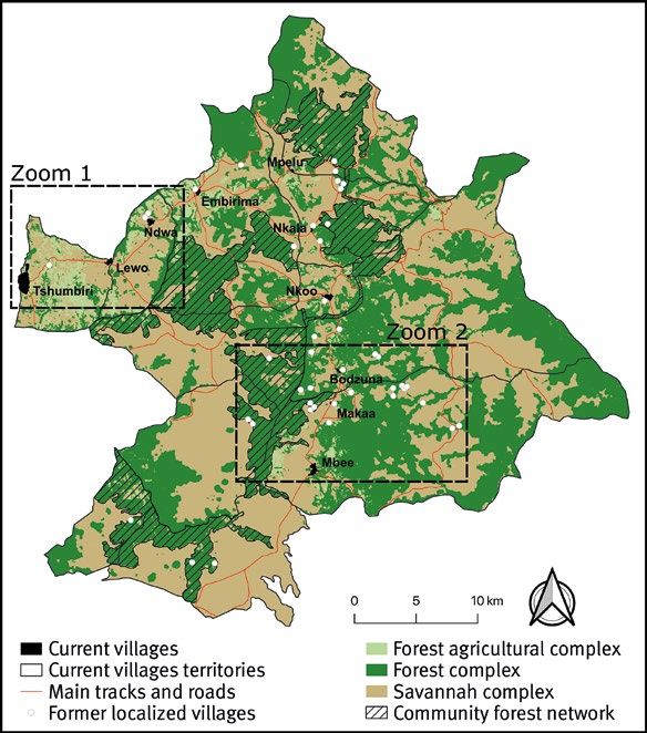
Bois et Forêts des Tropiques – ISSN : L-0006-579X
                                                                                                    Volume 348 – 2e trimestre – juin 2021 – p. 3-16
                                                          DYNAMIQUES VILLAGEOISES ET PAYSAGÈRES DANS UNE MOSAÏQUE FORÊT-SAVANE / LE POINT SUR…        9

Statistical analysis                                                Concerning villages that were regrouped, they became
       Two types of categorisations of former villages were         larger but did not reach the size of the present Mbee vil-
carried out following analysis of historical and geographi-         lage. In this sense, a 250 m-radius buffer zone, an average
cal data. The first categorisation classifies mobility into five    radius between the current Makaa and Mbee villages, was
historical periods according to results concerning the typo-        applied around each abandoned village to consider how
logy of mobilities and their causes: (i) before 1925, corres-       the landscape evolved since moving, and the percentage of
ponding to scattered villages before Belgian colonisation,          each landscape class was then determined for each buffer
(ii) between 1925 and 1935, corresponding to villages after         zone. A small buffer zone was chosen to focus exclusively
the sanitation phase, grouping scattered villages into lar-         on the evolution of the formerly inhabited area. GPS land-
ger ones, (iii) between 1935 and 1945, corresponding to             marks were taken in the centre of the former villages, as
villages grouped next to the road, (iv) between 1945 and            indicated by field informants. Then, percentages of each
1960, corresponding to villages voluntarily abandoned               classes were aggregated. The first PCA used five categories
during late colonial rule but following the two grouping            to study the impact of the date of mobility: (i) herbaceous
phases, and (v) after 1960 corresponding to villages aban-          savannahs, (ii) shrub savannahs, (iii) transitional areas
doned after independence. The second categorisation clas-           (area of savannahs colonised by pioneer forest species and
sifies abandoned villages according to their distance to the        evolving towards a forest state), (iv) terra firma land forests
closest active village related to the spatialization of human       and (v) wetland forests. Agricultural areas were included in
activities around villages, especially agriculture that is direc-   terra firma land forests, because swidden agriculture is prac-
tly linked to forest: (i) < 1 km, where forests are almost enti-    ticed in such forests. For the second PCA, agricultural areas
rely allocated to agriculture, (ii) between 1 and 2 km, where       were removed from the terra firma land forest class, since
cultivated fields are still plentiful with only a few residual      we sought to understand the relation between territorial
forest patches, (iii) between 2 and 4 km, where cultivated          exploitation and landscape structure, with distance as an
fields are progressively fewer and forest cover still largely       explanatory variable. The second analysis of the influence
preserved, (iv) between 4 and 8 km, where few village inha-         of distance on landscape composition relied on six land
bitants and breeders are opening up agricultural fields near        classes: (i) herbaceous savannahs, (ii) shrub savannahs,
their farm settlements, and (v) > 8 km, where agricultural          (iii) transitional areas, (iv) agricultural areas, (v) terra firma
activities are normally absent.                                     secondary and mature forests and (vi) wet secondary and
       Two Principal Component Analysis (PCA) were perfor-          mature forests.
med using R software. The first evaluated the impact of
the date of mobility (that is, the date when the village
moved to a new site) on landscape structure, specifi-
cally forest cover. The second assessed how former vil-
lage location and distance from the closest active village
influenced both current landscape structure and popula-
tion uses.
       PCAs were based on data from a land cover map
developed from remote sensing analysis with a 2016
Sentinel-2 satellite image (figure 3). This map categorizes
the landscape into 11 different classes according to a
hybrid categorization based on the field surveys that
accounted for structure and botanical composition and
local perception of the landscape. The methodology
used to produce this map, as well as the description of
landscape classes, can be found in a previously published
article (Demichelis et al., 2020).
       Current villages measure only a few hundred meters
in radius: 75 m-radius for Makaa, the smallest in the
area, compared to 400 m-radius for Mbee, the largest
one; Tshumbiri is not mentioned because of its particular
location along the river. Moreover, current villages have
undergone two phases of regrouping and a significant
demographic increase since independence and the last
mobilities even if no data are available. Their situation is
different from that of the former villages and thus cannot
be compared. In fact, abandoned villages before colo-
nisation most correspond to isolated and scattered vil-
lages, mainly family villages, which could be compared
to the current Makaa village – a small village that expe-
rienced no colonial regrouping (13 households counted).
                                                                      Figure 3.
                                                                      Land cover map of study area based on a 2016 Sentinel-2 satellite image
                                                                      and used to produce PCAs (Demichelis et al., 2020).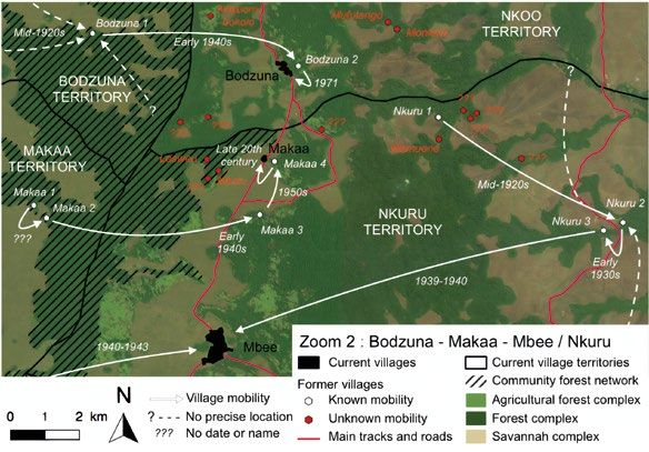
Bois et Forêts des Tropiques – ISSN: L-0006-579X
     Volume 348 – 2nd quarter - June 2021 - p. 3-16
10   FOCUS / VILLAGE AND LANDSCAPE DYNAMICS IN FOREST-SAVANNAH MOSAIC

                                     Results
                              Local migration histories

                     Although beyond the scope of the present
               analysis, recent mobility is part of a much lon-
               ger-term, centuries-old history of Batio migra-
               tion. According to oral histories, population
               movements resulted from multiple conditions:
               colonial relocations (called regroupement) for
               the establishment of colonial control; exhaus-
               tion of ecosystem resources and a subsequent
               search for new resources; adverse ecological
               conditions, and perceptions that particular sites
               were “unhealthy” for their inhabitants.

               Mobility histories of current villages
                    Figures 4 and 5 present known village
               mobilities from the 19th century to the present,
               based on recollections collected in FGDs and
               interviews. figure 4 illustrates past movements
               of Tshumbiri, Lewo and Ndwa villages.
                                                                          Figure 4.
                                                                          Mobility histories of Tshumbiri, Lewo and Ndwa villages.
               Tshumbiri history
                     According to collected oral histories,
               19th century Banunu people inhabited sites
               along the Congo river edge; Batio people lived
               on hilltops, further inland. At the end of the 19th
               century, a Protestant missionary consolidated
               the Nunu village Tsomba and two Téké villages
               to create the village of Tshumbiri. According to
               Tshumbiri elders, “The inhabitants were a little
               scattered, so they [the missionaries] asked eve-
               ryone to come closer to the Nunu village, and
               they changed the name [of the village] to honour
               the creator of the village Nunu [Tsumba], and it
               became Tshumbiri.”
                     Although Tshumbiri’s location did not
               change since its founding, its position contri-
               buted to its expansion as a market town connec-
               ting riverine traffic with a network linking villages
               in the interior. As an FGD with Tshumbiri elders
               indicated:
                     “The period of creation [of the road] was            Figure 5.
                                                                          Mobility histories of Bodzuna, Makaa and Mbee / Nkuru villages.
               around 1940, 1941, 1942. But before then,
               there were Portuguese traders and Africans too,
               [who] sold salt, pots, pieces of cloth, soap, all
               kinds of items. People living here sold kola nuts, palm nuts     clan villages, situated them next to the road. According
               and fibre to make bags. We also sold [ivory] secretly… But       to a focus group with Lewo elders, Belgian administrators
               after independence, the region became truly multi-ethnic.        “grouped [the small villages] on the roadside so that they
               [People from other ethnic groups] came here… to trade.           [Belgians] can have access to rubber and cotton, […] to
               They found that the environment was rich, that there were        be able to sell them and have the financial means [to pay
               many resources and land and that they could make many            taxes].” As elsewhere in central Africa, this colonial prac-
               purchases, but also that there were many customers.”             tice of regrouping facilitated tax collection and population
                                                                                control.
               Lewo history
                   Oral historical sources contend that Belgian colonial       Ndwa history
               administrators created Lewo in the early 1940s, following            Ndwa is composed of two villages: Ndwa 1, which
               road construction. Its creation consolidated scattered          existed prior to Belgian colonial rule, and Ndwa 2, created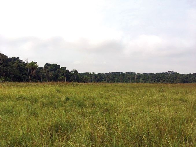
Bois et Forêts des Tropiques – ISSN : L-0006-579X
                                                                                                 Volume 348 – 2e trimestre – juin 2021 – p. 3-16
                                                        DYNAMIQUES VILLAGEOISES ET PAYSAGÈRES DANS UNE MOSAÏQUE FORÊT-SAVANE / LE POINT SUR…       11

in the 1930s from several villages that colonial administra-     and the women no longer gave birth. The Makaa clan is
tion consolidated next to what would become the road. A          in charge of the Nkira Mbali [the spirit protector of all the
focus group of Ndwa elders described the reasons for the         Batio of the chiefdom] so the clan perceived these evils as a
village regrouping, explaining that the colonial administra-     malediction for having left its ancestral lands. The clan chief
tors.                                                            then bought part of the Nkuru clan land and created a new
      “Told people who were far away that we had to move         Makaa [Makaa 4] on it.”
closer together to form a large village. It was really the            The village has moved incrementally a few hundred
state’s injunction. The state didn’t want to have people too     meters to position itself next to a small road.
far away, too isolated. They said that it was for health rea-
sons. If a woman was pregnant, it would difficult to receive     Nkuru history
treatment if you are far away. But also the mortality of men.          Nkuru village no longer exists, but its abandoned
We had to regroup, because it is not good to live in a bad       sites have taken on environmental features in collective
place.”                                                          memory. According to oral historical testimonies, the first
      In 1974, village opted to move to its current site to      village (Nkuru Mulilansie, named for a nearby river) was
be closer to the road, but also to escape from soil erosion      initially consolidated with several other clan villages, pro-
problems, from which its prior site suffered.                    bably sometime in the 1920s, when it was known as Nkuru
      Figure 5 summarizes mobilities of Bodzuna, Makaa           ebu (“Nkuru hole”). According to one elder, the dispersal
and Mbee villages. Red sites designate abandoned clan            of small-scale villages provided Belgian colonial autho-
villages, founded prior to colonization according to oral        rities with justification for this consolidation, and presu-
historical testimonies and currently recognizable by the         mably to distance populations from specific ecologies
abundant oil palms that continue to grow there.                  that facilitated reproduction of Glossina spp., the sleeping
                                                                 sickness vector. To facilitate sleeping sickness screening
Bodzuna history                                                  and control, Nkuru was regrouped with other clan villages
      The village Bodzuna 1 resulted from the consolidation      Mongwoli and Mamuene to create Nkuru 2 (Nkuru ebu),
of the clan village Bodzuna with several other clan villages     although local historical accounts indicate that this reloca-
in the mid-1920s. In the 1940s, as Belgian colonial autho-       tion precipitated resistance from local population against
rities sought to impose greater control over its subjects by     colonial subjects, leading colonial authorities to burn inha-
locating them closer to roads, Bodzuna village was relo-         bitants’ houses to force their migration.
cated to Nkoo clan lands. According to an elderly farmer               In subsequent years, the village voluntarily moved a
and merchant:                                                    few hundred meters to escape repeated floods of its prior
      “The old Bodzuna [Bodzuna 1] was a small village that      location (Nkuru 3, Nkuru mona, meaning dry or hill). Finally,
was grouped together with other small villages. It was there     in the early 1940s, colonial administrators consolidated
before I was born. The reason that inhabitants settled here      the village with that of Mbee and relocated the resulting
[Bodzuna 2] was because of the road. The Belgian colonial        settlement near a road forcibly constructed by local labour.
power asked us to leave to settle along the road.”               This same elder explained that Mbee’s road conditions
      In 1971, in the wake of forest expansion into the zone     were poor because of its proximity to swamplands.
of human settlement, the population decided to move a
few hundred meters to create the current village. Although       Archival evidence for village mobilities
the current village still must cope with forest expansion, its         In certain instances, the Africa Archives of the Fede-
population continues to exploit the abandoned village site       ral Public Service of the Foreign Affairs Service in Brussels
for palm nuts and cultivation. People use fire to keep forest    provide additional evidence for colonial village mobilities.
growth from encroaching on village spaces.                       Annual reports1 show that both Mbee and Mpelu villages
                                                                 moved in 1937. Administrators attributed this relocation
Makaa history                                                    of Mpelu to environmental conditions, namely seasonal
      Makaa 4, currently situated on the road near Bodzuna,      high humidity and cold that the village suffered because of
is the consequence of several Makaa village relocations.         its proximity to herbaceous flood savannah, confirmed by
Makaa 1 is the oldest recalled village, which seems to have      informants during FGDs. Mpelu was then consolidated with
existed at the end of the 19th century. Following the clan       other villages, prior to road construction in 1941. In addi-
leader’s death in this village, his son assumed his position,    tion, a hand-drawn map found in the 1940 Annual medical
creating Makaa 2 few hundred meters away. No precise             report from the Mushie medical service (dated from 1940),
period was mentioned for this migration, but it is possible      documents new village locations following “sanitation”
that it took place before or during the colonization. In the     regrouping and corresponds well with oral historical testi-
early 1940s, the colonial administration catalysed another       monies of Mbee and Bodzuna. Nkala (integrated with Nkoo
village relocation next to the road, creating Makaa 3, but a     at the time) and Lewo (not yet in existence, according to
decade later, the village moved again because of sorcery         oral testimonies) are both absent from the map.
accusations, resulting in the creation of Makaa 4. As a
50-year old man described the reasons for this last relo-
cation:                                                          1
                                                                  Annual report of indigenous affairs and labor, section B, chapter
      “The roosters no longer crowed, the crops were poor        XXI, 1937, 1941.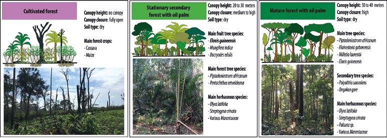
Bois et Forêts des Tropiques – ISSN: L-0006-579X
     Volume 348 – 2nd quarter - June 2021 - p. 3-16
12   FOCUS / VILLAGE AND LANDSCAPE DYNAMICS IN FOREST-SAVANNAH MOSAIC

                                  Impact of village mobilities                          Distance to current village and land use
                                    on landscape dynamics                                      Another PCA was conducted, which linked the distance
                                                                                        of abandoned villages to the nearest current village with
               Date of mobility and land cover composition                              land cover. Results are contained in figure 7.
                     First, the influence of the date of mobility on land cover                The PCA shows that the distance between abandoned
               composition was investigated. Figure 6 shows PCA results                 and current ones has a significant (Monte-Carlo test, p-va-
               which classified villages according the date of mobility and             lue 0.005**) influence on landscape structure. The first two
               land cover composition in a 250 m-buffer zone surrounding                components account for 66.39% of the variance (43.73% for
               GPS landmarks.                                                           axis 1, 22.66% for axis 2). Terra firma and wet forests posi-
                     The PCA shows significantly (Monte-Carlo test, p-value             tively influence axis 1, which in turn is negatively influenced
               0.01**) that the date of mobility directly influences lands-             by herbaceous and shrub savannahs, transitional areas,
               cape structure and composition. The first two components                 and agricultural fields. Axis 2 is positively influenced by
               count for 77.63% of the variance (44.22% for axis 1, and                 terra firma forest land (secondary and mature forests and
               23.21% for axis 2). Axis 1 is positively influenced by terra             agricultural fields) and similar to the PCA above, negatively
               firma forest land and to a lesser extent, wet land forest, and           by wet mature and secondary forests. Hence, axis 1 provi-
               negatively by herbaceous savannah, shrubby savannah and                  des information on forest cover and axis 2 on soil humidity.
               transitional areas. Similarly, axis 2 is positively influenced           According to the distribution of groups on axis 1, abandoned
               by wet land forest and negatively by terra firma forest land.            villages closest to current villages are the least forested, and
               Axis 1 thus provides information on forest cover, and axis 2             most exploited for agriculture. This dynamic is in play prima-
               on soil humidity. According to the cluster distribution on               rily for abandoned villages under one kilometre away from
               axis 1, then, older villages are most colonized by forest.               current villages. Conversely, the most distant villages seem
                                                                                        to be those with the most developed forest cover, so that
                                                                                                     resource exploitation appears to decrease as
                                                                                                     distance increases. Moreover, the distribution of
                                                                                                     the groups on axis 2 does not show a correlation
                                                                                                     between distance and humidity; all groups are
                                                                                                     distributed along axis 1.

                                                                                                    Land use and land cover change following mobi-
                                                                                                    lity according oral histories and botanical data
                                                                                                          Oral testimonies and focus groups indicate
                                                                                                    inhabitants entirely or partly abandoned their
                                                                                                    former villages following relocation, leading to
                                                                                                    three possible land covers.
                                                                                                          First, where inhabitants had previously
                                                                                                    planted many fruit trees and oil palms, people
                                                                                                    would return to abandoned villages to exploit
                                                                                                    these trees. In such cases, secondary forest
         Figure 6.                                                                                  coverage, characterized by pioneer forest spe-
         PCA based on date of village mobility and land cover                                       cies and oil palms, would persist in a relatively
         (Monte-Carlo test, p-value 0.01**).
                                                                                                    stable state.
                                                                                                          Second, once-cultivated lands near aban-
                                                                                                    doned villages could eventually revert to forest,
                                                                                                    which in turn expanded into the former villages
                                                                                                    themselves. The term efuna kuba in Batio lan-
                                                                                                    guage elucidates this phenomenon. Although
                                                                                                    this term has no direct translation, it expresses
                                                                                                    this process of forest colonisation of former vil-
                                                                                                    lages following inhabitants’ abandonment of a
                                                                                                    village. These abandoned villages overtaken by
                                                                                                    forest are identifiable in the landscape by the
                                                                                                    presence of oil palms. As one elder explained,
                                                                                                    “where these oil palms trees were have turned
                                                                                                    into forest. All places where oil palms grow are
                                                                                                    abandoned villages, which are now forest.”
                                                                                                          Finally, although forest may have colo-
         Figure 7.                                                                                  nized abandoned villages, people could return
         PCA based on the distance of abandoned villages from nearest current village               to these sites to cultivate fields because they
         and land cover (Monte-Carlo test, p-value 0.005**).                                        considered the land to be fertile. Note that if for-
Bois et Forêts des Tropiques – ISSN : L-0006-579X
Volume 348 – 2e trimestre – juin 2021 – p. 3-16
DYNAMIQUES VILLAGEOISES ET PAYSAGÈRES DANS UNE MOSAÏQUE FORÊT-SAVANE / LE POINT SUR… 13
mer villages are completely abandoned and no agricultural mental conditions, namely to escape adverse ecological, cli-
activity takes place there, oil palm trees tend to decrease in matic and health conditions, due to sorcery, the presence of
number over time and eventually disappear. Thus, traces of sleeping sickness vectors, flooding and depleted resources.
ancient villages may disappear over time, supplanted by a Oral historical sources were used in most cases to
mature forest resembling the rest of the forest network. document where, when, and why villages moved. However,
Figure 8 illustrates these three possibilities according historical recollections can be faulty (Giles-Vernick, 2002)
botanical data collected in former villages: (i) Stationary because of selective recollection and transmission of past
secondary forest with oil palm; (ii) Mature forest with oil events, people and processes. In fact, it can be difficult to
palm; and (iii) Cultivated forest. determine the precise date of a past event with only oral
Figure 9 highlights how village mobilities shaped sources. For example, the claim that missionaries facilitated
landscape dynamics, specifically in expanding the forest. the creation of Tshumbiri is inaccurate; Robert Harms, who
Finally, forest colonisation of abandoned villages is collected genealogies, oral histories and archival evidence
understood not only as an ecological process, but also a in the region in the 1960s and 70s, finds that Tshumbiri
social and historical one. Not only did it involve the culti- was likely established between 1800 and 1840 as a conse-
vation of a valued tree and result from village mobility, but quence of an expanding ivory trade (Harms, 1981). Yet trian-
some forest regrowth could be named for past people. The gulation with other complementary sources (Owens et al.,
forest patch Nzamatoro, for instance, was given the name of 2009; Caquard and Joliveau, 2016) – limited archival evi-
a respected elder who had been buried in his house prior to dence available, ecological observations with recording of
the village relocation. GPS points – allow some certainty about where abandoned
villages were located in relation to current ones. Although
Discussion triangulate data from different sciences and methods may
pose challenges, it can also be a strength: multiple sources
This study brings together oral historical knowledge of limit the bias associated with oral historical data and per-
village mobilities from the late 19th century to the present, mits an analysis of the consequences of past mobility on
some confirmatory archival evidence, and the development landscape dynamics over time, without the need for exact
of a GIS to evaluate the consequences of human mobility dating of events.
for land cover. Our analyses illus-
trated changing village mobility
within the Bolobo territory from
the late 19th century to the pre-
sent.
Local history of village mobility
linked to oral testimonies
Past changes within small-
scale, mobile African societies can
be contained in oral histories. The
present study relies on recalled
experiences of informants as well
as stories of mobilities that they Figure 8.
heard from older generations. Three possible landscape changes following village abandonment and forest colonisation.
There was unifying pattern in the
abandonment of villages or the
resettlement of others single rea-
son for mobility during the study
period. The study found village
mobility took place for multiple
reasons from the late nineteenth
century. Oral histories suggested
that there were two main drivers
of village mobility. The first is
linked to a common practice of
Belgian colonial rule, to consoli-
date populations and establish
colonial control (elsewhere, see
Pourtier, 1986; Rupp, 2011). The
second driver concerns human
populations’ response to environ-
Figure 9.
Landscape dynamics after village settlement and abandonment.Bois et Forêts des Tropiques – ISSN: L-0006-579X
Volume 348 – 2nd quarter - June 2021 - p. 3-16
14 FOCUS / VILLAGE AND LANDSCAPE DYNAMICS IN FOREST-SAVANNAH MOSAIC
Implication of village mobility analysis. These NGOs are primarily concerned with envi-
in landscape dynamics ronmental and species (notably bonobo) to maintain the
integrity of ecosystem services, as well as the promotion
Forest cover expanded into abandoned villages and of sustainable development. MMT has not only conducted
the savannahs, the consequence of environmental eutro- campaigns to conserve local practices of not hunting bono-
phication facilitating forest establishment. PCA analyses bos, but has also created community forests, which bar cer-
indicate that older villages were most colonized by forest tain extractive human activities (Narat et al., 2015ab). This
and that forest exploitation decreased with distance from governance of forest and wildlife use is complemented by
currently inhabited villages. There was no real correlation the development of ecotourism, and thus activities to bene-
between soil humidity and composition and date of village fit local populations and reduce anthropic pressure on the
mobility. Villages frequently resettled on dry savannah, but environment. This “integrated conservation and develop-
with a water source (river) in proximity. This repeated sett- ment” has long been an approach practiced by NGOs, but
lement pattern presumably facilitated the development its effects can be far-reaching, affecting livelihoods, and
of terra firma for settled villages and wet forests on village socio-cultural and political relations (Albers and Grinspoon,
outskirts along rivers. 1997; Agrawal and Ostrom, 2001; Panusittikorn and Prato,
What is striking about this multidisciplinary analysis 2001; Wilshusen et al., 2002; Jim and Xu, 2003; Roth, 2004;
of village mobility and landscape change is that the results West, 2006; West et al., 2006).
show multiple possible landscape changes over time, and In suggesting that past village mobilities have contri-
that village mobility does not necessarily lead to deforesta- buted to forest expansion, our study reveals that movement
tion. A process of eutrophication of the environment can be and environmental exploitation is not uniformly destructive
suggest here: by inhabiting new village sites and planting in African forests. This analysis also suggests that contem-
fruit trees, people enriched soils, and possibly attracted porary sedentarization of village settlements may place
avifauna species which by zoochory would have facilitated greater pressure on existing resources in proximity to vil-
seed spreading. In abandoning villages, people facilitated lages. NGOs would do well to heed these past dynamics and
the establishment of pioneer forest species on soils favou- risks, and to work closely with local populations to find ways
rable to their development, leading to the creation of a new of reducing stress on ecosystems within adversely affecting
forest. This creation of forest through human practices has local livelihoods. Developing alternative economies that
been noted elsewhere in Africa. Fairhead and Leach (1996), simultaneously protect the environment and respect exis-
for instance, found that people in Guinea were mainly res- ting human practices would be necessary to limit this pres-
ponsible of the creation of forest islands. De Foresta (1990), sure on forest ecosystems. Thus, the habituation of bonobo
in studying the Mayombe savannah dynamics elsewhere in communities by the MMF and WWF in a way to develop eco-
DRC, also highlighted the colonisation of savannahs by the tourism would be one a good starting point. It could make
forest over the last centuries, hypothesizing that a strong possible the development of a local service economy rather
past human occupation facilitated the installation of Maran- than an extractive one.
taceous forests. Similarly, in Sierra Leone, the existence of
forest patches around ruined villages has been highlighted, Conclusion
which now form a greater forest cover than the surrounding
forests (Nyerges and Green, 2000). This study sought to investigate the influence of past vil-
In the Bolobo Territory, Batio people have participated lage mobilities on the structure and dynamics of the forest-sa-
in forest colonization of savannahs, so that human presence vannah mosaic of the North Batéké Chiefdom in Democratic
has been favourable to the maintenance of forest cover, even Republic of Congo (DRC). Bringing together oral historical
in this fragmented ecosystem, and by implication, of bono- testimonies, geographical analyses and botanical data of
bos living in forest patches and protected by NGOs MMT and past and current village sites, the results suggest that Batio
WWF. It is true that certain zones here are heavily influenced peoples in this region of DRC have largely contributed to forest
by human activities, particularly the outskirts of current vil- expansion over time. At the same time, contemporary seden-
lages where agricultural production is most intense. Others, tarization of these inhabitants has encouraged intensified
however, initially “seeded” by human activities (fruit tree and localized exploitation of resources. Inhabitants shifted
planting), have been abandoned and left largely to ecologi- from pursuing relatively homogenous resource exploitation
cal processes. In the absence of village mobility, this situa- from scattered villages to a more heterogeneous resource
tion runs a high risk of overexploitation of resources around exploitation located around larger and regrouped villages.
villages, which negatively affects supply services, including This current, concentrated exploitation is risky, both for pro-
wildlife. tected bonobos, but also for biodiversity and for human live-
lihoods. NGOs and local populations must work together to
Contributions to conservation develop programs that protect bonobos and biodiversity and
and development programs foster human livelihoods on this forest edge.
Conservation NGOs working in this region have shaped Acknowledgements
governance of resource use and landscape dynamics, but We thank the entire Mbou-Mon-Tour team for their hospitality
can also learn from the insights produced by the present and support. We are most grateful to all local participants inVous pouvez aussi lire