Environmental change in the Great Whale River region, Hudson Bay: Five decades of multidisciplinary research by Centre d'études nordiques (CEN)1
←
→
Transcription du contenu de la page
Si votre navigateur ne rend pas la page correctement, lisez s'il vous plaît le contenu de la page ci-dessous
18 (3): 182-203 (2011)

Environmental change in the Great Whale River region,
Hudson Bay: Five decades of multidisciplinary
research by Centre d’études nordiques (CEN)1
Najat BHIRY2, Centre d’études nordiques and Département de géographie, Université Laval, Québec, Québec, Canada.
Ann DELWAIDE, Centre d’études nordiques, Université Laval, Québec, Québec, Canada.
Michel ALLARD, Centre d’études nordiques and Département de géographie, Université Laval, Québec, Québec, Canada.
Yves BÉGIN, Centre d’études nordiques and INRS - Centre Eau Terre Environnement, Québec, Québec, Canada.
Louise FILION & Martin LAVOIE, Centre d’études nordiques and Département de géographie,
    Université Laval, Québec, Québec, Canada.
Christian NOZAIS, Centre d’études nordiques and Département de biologie, chimie et géographie,
    Université du Québec à Rimouski, Rimouski, Québec, Canada.
Serge PAYETTE, Centre d’études nordiques and Département de biologie, Université Laval,
    Québec, Québec, Canada.
Reinhard PIENITZ, Centre d’études nordiques and Département de géographie,
    Université Laval, Québec, Québec, Canada.
Émilie SAULNIER-TALBOT, Centre d’études nordiques, Université Laval,
    Québec, Québec, Canada.
Warwick F. VINCENT, Centre d’études nordiques and Département de
    biologie, Université Laval, Québec, Québec, Canada.

                                   Abstract: The Great Whale River region on the eastern shore of Hudson Bay, Canada, encompasses the villages of
                                   Whapmagoostui (Cree First Nation) and Kuujjuarapik (Inuit) and surrounding areas. The principal field station of Centre
                                   d’études nordiques (CEN: Centre for Northern Studies) has operated at Whapmagoostui-Kuujjuarapik (W-K; 55° 15' n,
                                   77° 45' w) since the 1970s, with diverse research projects on past and present environments. The climate at W-K is strongly
                                   influenced by the proximity of Hudson Bay, and the recent pronounced loss of sea ice in this sector of northern Canada
                                   has been accompanied by large increases in air temperature. Discontinuous or scattered permafrost occurs throughout the
                                   region and is degrading rapidly. The W-K region continues to experience particularly rapid isostatic uplift in response to
                                   the retreat of the Laurentide Ice Sheet. Parabolic dunes occur along the coast and are strongly influenced by the plant cover.
                                   Paleoecological studies have documented the Holocene evolution of landscapes, including lakes, wetlands, and forests. The
                                   vegetation type is coastal forest tundra, with some 400 recorded species. Studies on certain insect groups provide a baseline
                                   for assessing future ecological change. The first signs of human occupation in the W-K region have been dated at 3800 BP.
                                   The arrival of the Hudson’s Bay Company in the 18th century marked the onset of continuous occupation. Rapid social,
                                   economic, and environmental change initiated in the mid-20th century continues to this day.
                                   Keywords: climate change, cryosphere, forest tundra, Hudson Bay, isostatic uplift, landscape, Subarctic.

                                   Résumé : La région de la Grande rivière de la Baleine, sur la côte est de la baie d'Hudson, Canada, comprend les villages
                                   Cri (Whapmagoostui) et Inuit (Kuujjuarapik), ainsi que les zones environnantes. Le Centre d’études nordiques (CEN) opère
                                   à Whapmagoostui-Kuujjuarapik (W-K : 55° 15' n, 77° 45' o) sa principale station de recherche depuis la décennie 1970. De
                                   nombreuses recherches portant sur l’étude des environnements passés et actuels y ont été menées. Le climat de la région
                                   est fortement influencé par la proximité de la baie d'Hudson où, depuis quelques décennies, la diminution de la glace de
                                   mer a été accompagnée d’une augmentation significative de la température de l'air. Le pergélisol est discontinu ou dispersé
                                   et présentement en dégradation. La région est caractérisée par un taux de relèvement isostatique particulièrement rapide
                                   en réponse au retrait de l’Inlandsis laurentidien. Des dunes paraboliques, situées le long de la côte, progressent en étroite
                                   relation avec le couvert végétal. Des études paléoécologiques ont documenté l'évolution holocène des paysages incluant les
                                   lacs, les zones humides et la forêt. La région de W-K est située dans la zone littorale de la toundra forestière. Sa flore, de type
                                   subarctique, comporte quelque 400 espèces recensées. Des études ciblées sur des groupes d'insectes spécifiques fournissent
                                   une base pour évaluer les changements écologiques futurs. Les premiers signes d'occupation humaine dans la région de W-K
                                   ont été datés à 3800 ans BP. L'arrivée de la Compagnie de la Baie d'Hudson au 18e siècle a marqué le début d'une occupation
                                   continue du territoire. Des changements sociaux, économiques et environnementaux rapides amorcés au milieu du 20e siècle
                                   se poursuivent encore aujourd’hui.
                                   Mots-clés : Baie d’Hudson, changements climatiques, cryosphère, paysage, relèvement isostatique, subarctique,
                                   toundra forestière.

1Rec.2011-04-21; acc. 2011-08-09
 Associate Editor: Steeve Côté.
2Author for correspondence.

DOI 10.2980/18-3-3469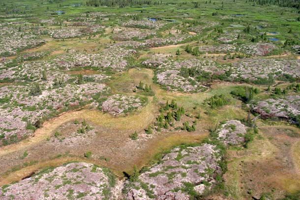
ÉCOSCIENCE, vol. 18 (3), 2011

                      Introduction                                                                   ds                              2
                                                                                                                                         1
                                                                                                  an
                                                                                                                     Hudson
                                                                                                sl                    Bay         4
     High-latitude regions of the Northern Hemisphere                                       ukI                                 3 2019
                                                                                        un
are experiencing rapid climate change, and considerable                            n ito                                      *Whapmagoostui-
                                                                                Ma
                                                                                                                          18 12 Kuujjuarapik
attention is now focused on the effects on north polar
geosystems and ecosystems. Climate models and obser-
vations imply that the fastest warming rates in the lower
atmosphere are occurring at latitudes from 75° n to the
North Pole (Screen & Simmonds, 2010). Although this                                                              8         11
has underscored the need to continue monitoring chan-
ges in the extreme High Arctic (Vincent et al., 2011),                                 17
there are other regions of the circumpolar North that are                                              10                            21
also experiencing large shifts in climate, accompanied by                       22
                                                                                                             9
impacts on landscapes, vegetation, and wildlife. One such                6                                            7         14
area is the eastern Hudson Bay region of subarctic Quebec,      Whapmagoostui-
Canada, where the climate, permafrost, and many biological      Kuujjuarapik 7
                                                                                                                                     60° W
communities appear to be in a state of rapid transition                   5, 13,                                 60° N
(Payette et al., 2004).                                                   15, 16
                                                                                                                                 Labrador
                                                                                                                                   Sea
                                                                                                                 Hudson
     The Centre d’études nordiques (CEN: Centre for                                                                     Whapmagoostui-
                                                                                                                  Bay Whapmagoostui-
Northern Studies) began studies in the Great Whale River                                                                   Kuujjuarapik
                                                                                                                           Kuujjuarapik   area
                                                                                                                                        area
area, southeastern Hudson Bay, in the 1960s based out of                                                                      QUÉBEC
Whapmagoostui-Kuujjuarapik (W-K; 55° 17' n, 77° 47' w),                                                          50°
                                                                                                                 50° N
                                                                                                                     N
at the mouth of the Great Whale River (Figures 1 and 2).          0      1 km
In 1968 CEN began to develop a research station in the vil-                                                                   Montréal
                                                                                                                              Hudson
                                                                                                                              Montréal Bay
lage of W-K, on the site where it had inherited buildings
                                                                   F igure 1. Location of the Great Whale River region and sites
from the Quebec government. Over the years, this became         mentioned in the text.
the principal site for the CEN Network of field stations
(Qaujisarvik, meaning “place of study” in Inuktitut), which     The region is underlain by discontinuous, scattered perma-
extends over 3500 km from Radisson (53° 47' n, 77° 37' w)       frost (Allard & Seguin, 1987) in the forest subzone of the
in the James Bay region to Ward Hunt Island (83° 6' n,          forest tundra zone (Payette, 1983).
74° 10' w) at the northern tip of North America, and which            The Great Whale River (Grande rivière de la Baleine
since 2009 has been part of SCANNET, the circumpolar            in French) flows 724 km, from Lake Saint-Luson, through
network of terrestrial field stations. The W-K station was      Lake Bienville, to the sea at W-K (Figure 2a). With a drain-
established in the early seventies in the wake of the early     age basin of 42 735 km2, it is one of the most important
development of “Hudsonie”, the CEN’s multidisciplin-            rivers of northern Quebec, achieving peak flows of around
ary research project in 1968-1969 (Hamelin & Cailleux,          1740 m3·s–1 in late May (Déry et al., 2005) and an annual
1968). The aim of this project was to collect preliminary       average discharge of 700 m3·s–1 (Grainger, 1988). Its influ-
geomorphological, climatological, and ecological data.          ence also extends well into the sea, exporting organic car-
Since then, CEN research has not only intensified, but has      bon and nutrients (Hudon et al., 1996; Retamal et al., 2007)
also greatly broadened its research on the region’s geo-        and producing a freshwater plume that extends offshore
systems and ecosystems, with emphasis on environmental          over an area of about 100 km 2 of coastal Hudson Bay
change in the past and present. Our aim is that this review     in summer and autumn, increasing up to 1000 km 2 in
article, written in commemoration of the 50th anniversary       February and 2000 km2 in March (Ingram, 1981). The Great
of the founding of CEN, will serve as an introduction to        Whale River and its freshwater plume have been studied by
the subarctic Great Whale River region, and that it will        researchers based out of the CEN Station at W-K, but a full
provide a basis for comparisons with other sites in the fast    account of these and related studies on the coastal marine
changing North.                                                 ecosystem that it discharges into is outside the scope of the
                                                                present review. The W-K area also contains numerous lakes
               Great Whale River region                         that have been the subject of limnological research that is
                                                                still ongoing (e.g., Rae & Vincent, 1998; Swadling et al.,
     The region covered by this article includes the adjacent   2001; Rautio & Vincent, 2006; Laurion et al., 2010;
Cree (Whapmagoostui; “place of the beluga” in Cree) and         Watanabe et al., 2011; see also Rautio et al., 2011) and
Inuit (Kuujjuarapik; “little great river” in Inuktitut) vil-    paleolimnological studies (reviewed below).
lages that host CEN’s research station and the surrounding
area. We include in this region the area within 50 km north,
10 km south, and 15 km east of W-K (bounded to the west                       Climate and snow conditions
by the sea) to encompass the full range of environmental             The subarctic climate of the W-K region was described
studies by CEN researchers based out of the W-K station.        in detail by Wilson (1968) for the period 1932 to 1960,
The region is located on the southeastern part of Hudson        and a compilation of subsequent data from 1961 to 2000 is
Bay (Figure 1) and encompasses an area of about 900 km2,        provided by Environment Canada (2010). Climate normals
including the Manitounuk Islands and Manitounuk Strait.         for these periods were similar. Mean annual temperatures

                                                                                                                                               183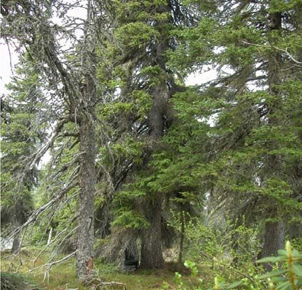
Bhiry et al.: Environmental change in the subarctic
a)
b) c)
d) e)
f)
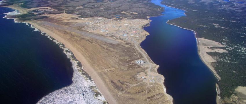
Figure 2. a) Whapmagoostui-Kuujjuarapik on the Great Whale River, subarctic Quebec, Canada. The sea is on the left (Strait of Manitounuk,
Hudson Bay) and the river is on the right. b) Old-growth forest located in the Cri Valley. c) Sasapimakwananisikw palsa bog, located 8 km south of the
village. d) Lake Kachishayoot, located about 3 km inland from the eastern shore of Hudson Bay on granite-gneiss rocks of the Precambrian Canadian Shield.
e) Cree campsite located in the spruce–lichen on the south bank of the Great Whale River. f) Manitounuk Islands viewed from the coast.
184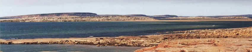
ÉCOSCIENCE, vol. 18 (3), 2011

   were –4.2 °C for 1932–1960, –4.5 °C for 1961–1990,                     the proximity of the shore, the relief of the land, and the
   and –4.4 °C for 1971–2000. However, mean annual                        broader structural types of the local vegetation. The coastal
   temperatures have been considerably higher over the last               area retains the least snow, as it is most exposed to the pre-
   decade (2000–2010), and negative temperature anomalies                 vailing winds coming off the bay. The snowiest sites are the
   (i.e., mean annual temperatures less than the 20th century             depressions, steep slopes, and deep bedrock fractures. These
   average for W-K) are now rarely observed (Figure 3).                   relief types are also characterized by early snow cover and
   Mean annual air temperatures for the period 2001–2010                  late snow thaw. In forested sites, the thickness and density
   averaged –2.6 ± 1.2 °C, significantly above that for 1960–             of the snow cover increase with altitude. In exposed sites
   2000 (–4.3 ± 1.6 °C; t = 3.78, P < 0.001). January has                 dominated by low-growing vegetation, the snow cover
   always been the coldest month, with mean temperatures                  thickness may vary, although its density is uniform and
   of –22.8 °C (1932–1960) and –23.4 °C (1961–2000), and                  generally high (Filion & Payette, 1976). In forested stands,
   August has been the warmest, with respective means of                  snow and sunlight are intercepted by the canopy, resulting
   10.6 and 11.4 °C. Mean annual precipitation was 680 and                in lower soil temperatures than at open sites (Filion &
   656 mm, respectively, 40% of which fell as snow (Wilson,               Payette, 1978).
   1968; Environment Canada, 2010). Average wind speed is                      Sea ice conditions in Hudson Bay have been changing
   5.6 m·s-1 (1932–2000). Wind direction varies seasonally;               rapidly over the last decade, and the climate of W-K is
   winds are predominantly easterly and south-easterly in                 undergoing shifts that are without precedent for at least
   autumn and winter but northerly in the spring and summer.              90 y, and perhaps much longer. A compilation of remote
   Average monthly wind speeds are greatest from September                sensing data from the Canadian Ice Service archives shows
   to December, during which time the strongest winds are                 that sea ice decline in Hudson Bay has been faster than in
   usually associated with the passage of atmospheric lows.               any other Canadian Arctic region, decreasing at an aver-
   The wind has a major effect on the distribution pattern and            age rate of 11.3 ± 2.6% per decade between 1968 and
   compaction of the snow cover and on the distribution of                2008 (Tivy et al., 2011). These declines have continued;
   permafrost and vegetation.                                             in January 2011, open water conditions were observed in
         The climate at W-K is greatly influenced by the prox-            Manitounuk Strait (C. Tremblay, CEN station manager,
   imity of Hudson Bay, more specifically by the extent of ice            pers. comm.). This dramatic > 40% overall decline in sea
   cover (Wilson, 1968). Once the bay freezes up, usually from            ice coverage has been accompanied by unusually high air
   January to May, the area’s climate becomes continental,                temperatures. For the most recent annual record (2010), the
   with cold temperatures, low precipitation, and reduced                 temperature anomaly at this Environment Canada station
   cloudiness. In summer and fall, the climate reverts to the             was more than 7 times the global average (Figure 3).
   maritime type, and sunshine is greatly reduced, chiefly
   due to the frequent dense fogs, particularly along the coast                   Permafrost and periglacial processes
   (Plamondon-Bouchard, 1975). As in all northern regions,                     Permafrost is an important factor in northern land-
   snow is a major ecological and geomorphological fac-                   scapes. The W-K region is located in the discontinuous,
   tor. In winter, the snow fills depressions and valleys and             scattered permafrost area and lies in zone C of the northern
   thereby produces a more even topography. The region’s                  Quebec permafrost distribution map (Figure 4a, Allard
   snow cover dynamics were studied by Payette and Lagarec                & Seguin, 1987; Payette, 2001). In this region, perma-
   (1972), Filion (1976), and Filion and Payette (1976; 1978).            frost occupies much less than 50% of the land surface
   The thickness of the snow cover varies depending on                    and is principally concentrated on barren hilltops. In cer-
                                                                          tain areas, permafrost may be as much as 100 m thick
                            6                                             (Botteron et al., 1979).
                                                                               More specifically, the W-K region is in sub-sector C1,
                                                                          which was described by Allard and Seguin (1987) as an
                            4
                                                                          area characterized by palsas overlying fine Tyrrell Sea sedi-
Temperature anomaly (°C)

                                                                          ments and by scattered permafrost under exposed bedrock
                            2                                             hills in the wind-blown rocky hills along the coast. The
                                                                          earliest research work on the region’s permafrost dates
                                                                          back to 1969. Some palsas in a peat bog 8 km south of
                            0                                             W-K (Figure 2c) were described by Hamelin and Cailleux
                                                                          (1969), and later by Botteron et al. (1979). Rocky mounds
                                                                          of periglacial origin (later referred to as heaved bedrock
                           –2                                             features; Dionne, 1984) were also observed in certain areas
                                                                          of subarctic Quebec, notably in the basaltic bedrock of the
                                                                          Manitounuk Islands. These mounds were characterized
                           –4
                            1920   1940   1960       1980   2000   2020   as belonging to 3 morphological types: crevassed blocky
                                                 Year                     mounds, centrally or peripherally blocky mounds, and
                                                                          gelifract-covered mounds (Payette, 1978). These forms
     F igure 3. The air temperature anomaly (deviation from the 20 th
 century mean value) for Kuujjuarapik. The data are from Environment
                                                                          owe their shape to the build-up of hydraulic pressures in the
 Canada (circles), and the full line gives the mean global anomaly        active layer of the bedrock and to gelifraction (Michaud &
 (http://data.giss.nasa.gov/gistemp/tabledata/GLB.Ts.txt).                Dionne, 1987).

                                                                                                                                    185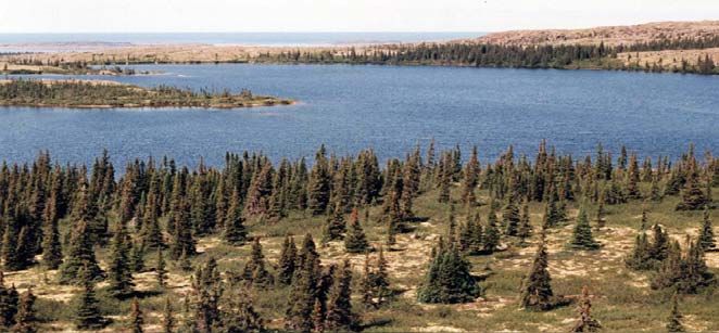
Bhiry et al.: Environmental change in the subarctic

a)                                   A                              b)

                              B1                                                               Hudson                         TF
                                                                                                Bay
                                                 B
                   Hudson
                    Bay
                                                                                     WHAPMAGOOSTUI-
                                    C1               C               55°
                                                                                      KUUJJUARAPIK
      WHAPMAGOOSTUI-
  55° KUUJJUARAPIK

                                                                                                                         FO
      James                         D
                                    C                                        James
       Bay                                                                    Bay

 A: Continuous permafrost                                                   Syn- to late-tectonic granitic rocks
 B: Discontinuous permafrost (more than 50% of
                                                                            Syn- to late-tectonic tonalitic rocks
    land surface)
 Sub-zone B1: Major concentration of permafrost area                        Orthopyroxene granitoids syn- to late-tectonic
    plateaus and mounds in clayey silts of Tyrrell Sea                      Granitoids diatexite syn- to late-tectonic
 C: Discountinuous and scattered permafrost (less than
                                                                            Arenite, stromatolitic dolomite and basalt
    50% of land surface), present under exposed hills
                                                                            (Richmond Gulf and Nastapoka groups)
 Sub-zone C1: Area characterized by palsas overlying fine
    Tyrrell Sea sediments
 D: Sporadic permafrost (less than 2% of land surface)
   Figure 4. Permafrost distribution a) and geology b) of the Whapmagoostui-Kuujjuarapik area. Modified from (a) Allard and Seguin (1987)
and (b) ministère des Ressources naturelles et de la Faune (2002).

     On the cuestas ridges with a cliff on one side and gentle           & Allard, 1996). This analysis was for the period immedi-
slope on the other of the Manitounuk Islands, data regarding             ately prior to the marked recent warming of the W-K region,
permafrost distribution and thickness were collected via                 and thereby establishes a useful set of baseline conditions.
electrical resistivity surveys (Seguin & Allard, 1984;                        The study of cryofacies making up a permafrost plateau
Figure 1, site 1; Figure 2f). In some places, permafrost can             along the inner coastline of Manitounuk Strait showed that
reach thicknesses of some 30 m, notably in the Proterozoic               different thermal regimes generating different geomorpho-
basalts and quartzites of the cuestas. The fact that there is            logical evolutionary processes can indeed coexist within a
no permafrost at altitudes of less than 20 m has been attrib-            single plateau (Caron, 1995). The evolution of this perma-
uted to the moderating effect of the adjacent sea. Permafrost            frost plateau was reconstructed through the use of thermis-
was also found in marine clays on the eastern side of                    tor cables, cryostratigraphy, repeated snow sampling, and
Manitounuk Strait. Many periglacial landforms closely                    a dendrochronological analysis of the spruce trees that
associated with the local presence of permafrost have been               colonized the plateau’s summit and flanks (Allard, Caron
observed: thufurs (turf hummocks), heaved bedrock fea-                   & Bégin, 1996; Figure 1, site 2). Four distinct cryostrati-
tures, clastic dykes, and mud volcanoes. The cliff fronts of             graphic layers were identified (I, II, III, and IV), which
the cuestas are sites of rockfalls, which lead to the forma-             can be differentiated by the structure and quantity of their
tion of taluses and boulder fields at the base of the cuestas            ice content. The data showed that around 1830, Layer III,
(Belzile, 1984).                                                         which is low in ice content, was formed during the first
     A synopsis of the early research on northern Quebec’s               few years of frost penetration. The permafrost subsequently
permafrost, including the W-K region, is given in Allard                 deepened, inducing the formation of ice-rich Layer IV.
and Seguin (1987). Based on Payette, Samson, and Lagarec                 Since 1940, thermokarstic marshes have been the domin-
(1976) and regional observations, this study demonstrated                ant form around the edges of the plateau, while forest
the close relationship among the presence or absence of                  cover became established in the depressions and on the
permafrost, its thickness and thermal regime, the snow                   slopes. Also since the late 1940s, degradation of permafrost
cover, and the structure of the forest cover. On the basis of            plateaus along the coast is responsible for coastal retreat
these many relations, the authors proposed a permafrost dis-             despite the general land uplifting that is taking place due to
tribution map (Figure 4a; Payette, 2001). A digital landform             rapid postglacial rebound (Beaulieu & Allard, 2003).
model was also devised for various sectors of a cryogenic
plateau in the Manitounuk Islands. Winds, vegetation, and                   Geology, geomorphology, and the Quaternary
topography were used to forecast snow cover potentials.
The results suggest that the state of the permafrost may vary            Geology and geomorphology
over even short distances as a function of local conditions,                There are 2 distinct physiographic assemblages in the
particularly topography, vegetation, and snow cover (Roche               W-K region (Figure 4b): 1) the Archean granito-gneissic

186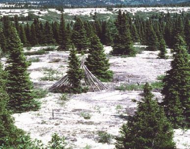
ÉCOSCIENCE, vol. 18 (3), 2011

basement forming the majority of the continent, whose                    late-Wisconsinian flow of ice was toward the west, indicat-
relief essentially consists of low rolling hills and depres-             ing that it radiated outward from the middle of the Quebec-
sions that are generally aligned along an east–west                      Labrador peninsula. As in other regions along the Hudson
structural axis; and 2) volcano-sedimentary formations                   Bay coastline, isostatic uplift continues to be among the
constituting a string of islands (the Manitounuk Islands)                most rapid in the world, at ca 13 mm·y‒1 (Lavoie, 2006).
that rise in the form of cuestas paralleling the coast, the                   The study of multiple forms of erosion and uplifted lit-
offshore side of which slopes down to the sea at an angle                toral accumulations has enabled measurement of the emer-
of 5 to 10 degrees. Biron (1972) conducted a study of the                gence of the eastern Hudson Bay coastline, which began
area’s geology that greatly built on and extended previous               about 8000 cal. y BP (Allard & Tremblay, 1983a; Lavoie,
observations (Biron, 1972 and references therein; Kranck,                2006). The rate of emergence was quite high at the outset
1951; Woodcock, 1960; Eade, 1966; Stevenson, 1968;                       (on the order of 9–10 m per century; Lavoie, 2006) but
Dimroth et al., 1970). The Proterozoic rocks along the edge              diminished significantly thereafter to settle at approximately
and just offshore of the Hudson Bay coast were named the                 1 m per century as of about 2800 cal. y BP. Similar results
Manitounuk Supergroup. This supergroup has been div-                     have been obtained for other parts of the region (Figure 5)
ided into 3 separate assemblages distinguished on the basis              (Ricard & Bégin, 1999; Cayer, 2002; Miousse, Bhiry &
of angular discordance: the Pachi Group, the Richmond                    Lavoie, 2003; Drouin, 2004). The emergence curve for
Group, and the Nastapoka Group. According to Chandler                    the past thousand years provides a maximum date for the
and Parrish (1989), the formation of Richmond Gulf Group                 inception of many terrestrial landforms and processes at ele-
is related to the initial rifting of the Trans-Hudson Orogen.            vations below 250 m in the coastal region, including peri-
The Proterozoic rocks found in the W-K area belong to the                glacial processes, formation of permafrost, peat inception,
Nastapoka Group, composed of stromatolithic dolomites                    formation of soils, aeolian processes, isolation of lacustrine
overlain by quartzites and basalts. A peperite deposit stud-             basins, and initial colonization by vegetation.
ied by Biron (1972) demonstrated that the site is the result                  The Quaternary deposits in Manitounuk Strait have
of a blend of fluidal lavas and dolomitic muds.                          been identified through seismic stratigraphy (Hill, Simard
     Formations whose age range lies between the                         & Héquette, 1999; Figure 1, site 3). Three distinct acoustic
Proterozoic and the Quaternary do not exist in the region.               units were identified. The bottom layer, Unit 1, is strati-
Quaternary sedimentary coverage is discontinuous; fluvio-                fied and seems to be of glacio-marine origin. The median
glacial and morainic deposits exist as outcrops overlying the            layer, Unit 2, is made up of current- and gravity-driven
Precambrian basement. Marine clay deposits have filled the               deposits that were established during a period of numerous
bottoms of larger valleys and structural depressions. Sandy              earthquake events. Unit 3 is of marine origin, which was
deposits of marine, deltaic, or fluvial origin were sifted               confirmed by its content of pollen grains and dinoflagellate
by wind action, leading to dune formation in some places                 cysts. On the eastern shore of Manitounuk Strait, 3 types
(see below).
     Deglaciation and the rate of isostatic uplift east of the                                   140                                 Wood
region were first studied by Lee (1960; 1962). The first                                                                             Mytilus edulis
geomorphological data for the W-K region were gath-                                                                                  Mixed shells
ered over the course of the “Hudsonie” project (Hamelin                                          120                                 Plant macrofossil
& Cailleux, 1968). The descriptions of landforms at                                                                                  (Lake Kachishayoot;
                                                                                                                                     Miousse et al., 2003)
                                                                 Altitude above current sea level (m)

that time paved the way for proper identification of the
region’s major geomorphological characteristics and pro-                                                                             Plant macrofossil
                                                                                                 100                                 (Lake Kachishayoot;
cesses (Cailleux, Hamelin & Cartier, 1968; Hamelin &                                                                                 Saulnier-Talbot
Cailleux, 1968; Cailleux & Hamelin, 1969; Hamelin &                                                                                  & Pienitz, 2001)
Cailleux, 1969; Portmann, 1970; 1971; Hillaire-Marcel                                                   80                           Plant macrofossil
& de Boutray, 1975). The region has conspicuous glacial                                                                              (Lake Kaapumticuumac;
and postglacial features. Geomorphological features such                                                                             Cayer, 2002)
as crests, lakes, and valleys are all aligned along 2 major                                             60
axes (60° n and 110° n). Glacial striations occur in 2 main
directions, nw and wsw (Parent, Paradis & Boisvert, 1995).
There are abundant vestiges of the Tyrrell Sea, including                                               40
boulder fields, shelly clay, terraces, a delta, and coastal
dunes. Peatland palsas were also inventoried and described.
Based on the stratigraphy of unconsolidated deposits in the                                             20
region, Hillaire-Marcel and de Boutray (1975) were able to
reconstruct the main deglaciation stages: deposition of the
Sakami moraine, a lacustrine or marine phase distinguished                                               0
by ice-contact fans, then a series of rhythmites followed by                                             8000 7000   6000 5000 4000 3000 2000 1000        0
transgressive deposits from the Tyrrell Sea under a layer of                                                                 Cal. y BP
regressive, deltaic, and alluvial sediments. The rapid iso-                 Figure 5. Emergence curve of the Whapmagoostui-Kuujjuarapik area.
static uplift of the region was described by Andrews (1968)              Modified from Allard and Tremblay (1983), Saulnier-Talbot and Pienitz
and Hillaire-Marcel (1976). It was concluded that the                    (2001), Cayer (2002), and Miousse, Bhiry, and Lavoie (2003).

                                                                                                                                                        187
Bhiry et al.: Environmental change in the subarctic
of staged shoreline have been identified (Ouellon, 1997). away by ice keels as uplift raised the bottom over time. This
Between 120 and 90 m altitude, irregularly shaped paleo- implies that hydraulic processes alone cannot explain all the
shoreline rocks or boulders have been laid at the foot of observed nearshore seabed erosion, which is largely caused
slopes. Between 90 and 20 m, the raised shorelines are char- by ice scouring, resuspension of unconsolidated sediments,
acterized by sandy sediments that have occasionally been and their subsequent advective loss from the site by cur-
sorted by wind action. At 20 to 0 m altitude, shoreline sedi- rents. This mechanism also partly explains the erosional
ments are fine-grained and more susceptible to permafrost nature of the tidal flats in the strait, which essentially con-
formation and freeze–thaw processes. sist of Holocene marine sediments overlain by a veneer of
modern intertidal deposits (Ruz et al., 1998; Ruz, 2005).
Coastal dynamics Cloutier (1996) demonstrated that littoral forms such
Allard and Tremblay (1983a,b) described the action as beaches develop more slowly along the Hudson Bay
of frost riving in bedrock along the shoreline. The roches coast than along temperate coasts due to the inertia of cold-
moutonnées and the glacially polished surface on the basalt water masses. Nevertheless, sudden changes in these coastal
of the Manitounuk Islands are becoming locally dismantled landforms can occur, caused by the high energy waves and
and eroded by the combined action of gelifraction, sea push currents associated with storms, principally in autumn.
ridges, and storm waves. Through radiocarbon dating of Measurements of longshore sand transport near the mouth
raised cobble beaches and cobble fields they also concluded of the Great Whale River estuary showed that consider-
that cold periods such as the Little Ice Age favoured ice able increases in bedload and suspended sediment transport
push features along the coast rather than wave-borne cobble occur during fall and freeze-up seasons compared to sum-
beaches. In the W-K region, shoreline dynamics are gov- mer (Héquette & Tremblay, 2009). The increase in sediment
erned by the combined influences of gelifraction (and/or the transport associated with low water temperatures is believed
ice foot), storm surges, tidal currents, and sea-ice–related to be mainly due to lower sediment fall velocities resulting
processes. Bégin (1981) studied shore ice processes and from an increase in fluid viscosity. These results suggest
their impacts along the shores of the estuary of the Great that in cold climate regions there may be a substantial
Whale River and on the raised shores of the Tyrrell Sea. increase of coastal sediment transport during near-freezing
During the 4 successive stages of the ice season (freeze-up water conditions.
stage, ice formation on shorelines and water bodies, full
winter stage, and finally estuarine and marine break-up Wind activity and dune-building
stage), frost and ice play a major role in the formation of Dunes and other eolian landforms in the W-K region
sandy/rocky beaches and foreshores (Bégin, 1981; Bégin & were intensively studied by Filion and Morisset (1983),
Allard, 1982). Filion (1983; 1984a,b), Bélanger and Filion (1991),
A study of the littoral dynamics of a small bay with Filion et al. (1991), Marin and Filion (1992) and
coastal mudflats on the eastern shore of Manitounuk Saint-Laurent and Filion (1992). Virtually all of the region’s
Strait identified numerous features built up by frost action dunes are of the parabolic type, although their spatial
(Moffet, 1987): laminar clay flows, clastic dykes, frost- arrangement reflects the variable direction of the wind and
heaved boulders, and stone circles. A neighbouring low local ecological conditions. In the boreal and sub-boreal
terrace featured frost cracks, frost boils (ostioles), frost zones of the forest tundra, for example, the dunes are per-
mounds, and frost blisters. This study suggested that storm pendicular, opposite, and hemicyclic, as a result of the
surges pushed the shoreline far inland between 1952 and multidirectional winds from the n, se, s, or sw (Filion &
1974. However, periglacial processes, as controlled by the Morisset, 1983). In the shrub sub-zone of the forest tun-
ice foot and its own thermal regime, seem to have been dra, dunes are imbricated or laid out in step-wise fashion,
the main factors in the littoral dynamics of the soft deposit reflecting their deposition by easterly winds (Figure 6). The
shoreline in Manitounuk Strait (Allard et al., 1998; Ruz dunes may move and grow in forested sites, burying trees
& Beaulieu, 1998; Beaulieu & Allard, 2003). The gradual located on the leeside of the front and further exposing them
penetration of frost under the ice foot that covers the clayey in the inner depression with dune progression. White spruce
shoreline has led to the formation of segregation ice, the so affected can adapt to sand deposition and erosion by
damming of groundwater flow (translating into icings), developing growth forms enabling them to survive (Marin
frost blisters, and lens-shaped bodies of intrusive ground ice & Filion, 1992; Figure 1, site 5). As expected, forest cover
(hydrolaccoliths) (Allard et al., 1998). During ice melting in influences the progress of the dunes. As an example, trees
spring, landforms cave in and collapse and mud flows are growing between dune ridges force the ridges to move and
common. The released sediments are then washed away by expand in diverging directions under the multidirectional
wave action and tidal currents. effects of the wind, resulting in digitate dunes (Figure 6).
Héquette, Tremblay, and Hill (1999) found that free- This close relationship between dune activity and
drifting floebergs, which initially form as pressure ridges in plant cover was recorded in the course of stratigraphic
Hudson Bay, also play a major role in the erosion of near- analysis of dune deposits and paleosols, enabling Filion
shore unconsolidated sediments in the Manitounuk Strait (1983; 1984a,b) and Filion et al. (1991) to document
(Figure 1, site 4). High-resolution seismic profiles indi- wind activity in relation to climate during the Holocene.
cate that in areas where water depth is less than 15 m and Several periods of high wind activity were recorded after
where waves are of low energy and the currents are weak, a 5000 BP, with a periodicity of 350 to 400 y, especially
10-m-thick layer of sediment has been progressively eroded between 3250 and 2750 y BP, 1650 and 1050 y BP, and
188ÉCOSCIENCE, vol. 18 (3), 2011
niveo-eolian sand deposition and spring thaw were respon-
Imbricated dunes Perperdicular or
normal-incident dunes
sible for major damage to trees growing close to active
Building (Aufrère, 1931) dune ridges.
winds The pivotal role of niveo-eolian sand deposition was
also noted with respect to the formation of a series of dunes
paralleling the beach at W-K. These dunes likely developed
Dunes laid out in during periods of low sediment transport and slow beach
stepwise fashion aggradation (Ruz & Allard, 1994, Figure 1, site 6). They
Dunes in opposition
(David, 1977) probably formed in conjunction with isostatic uplift, at the
(Aufrère, 1931)
rate of 1 dune series every 100 y (Ruz & Allard, 1994).
Niveo-eolian sand sedimentation during the snow season
was found responsible for coarse-grained sand beds in vege-
tated coastal dunes (Ruz, 2005). In non-vegetated dunes,
coarse-grained sand beds were reshaped after the melting
Hemicyclic dunes Acute-incident dunes of snow interstratified with sand. The coastal aggradation
(Aufrère, 1931) plain is thus made up of a series of parallel dunified beach
ridges in which niveo-aeolian processes play a role (Ruz &
Allard, 1995).
At many sites located close to or within W-K, wind-
borne sediments have been reworked by human activities.
Digitate dunes A military base was erected at this location in 1955 and
Obtuse-incident dunes 2 landing strips were built across the village, which initiated
the destruction of the plant cover and subsequently exposed
the sand surface to wind erosion. This situation is worsen-
ing as the village expands and as all-terrain vehicle use
increases (Desormeaux, 2005). There are ongoing studies
by CEN researchers to develop plant restoration strategies
F igure 6. Spatial arrangement of the parabolic dunes in the
Whapmagoostui-Kuujjuarapik area. Modified from Filion and for remediating these effects.
Morisset (1983).
Landslides
750 y BP to present. Buried organic horizons in sand dune Past landslides in the W-K region had an impact on the
deposits attest to the alternating phases of stabilization sandy terraces located on the left bank of the Great Whale
(by vegetation and soil formation) and wind erosion. River. Over about a dozen kilometres, from its mouth to
Charcoal fragments in the organic horizons bear witness the first waterfalls, landslide scars were first reported by
to the determining influence of forest fires at the site scale. Cailleux (1972), Portmann (1972), and Demangeot (1974).
Soils are exposed after a fire event, becoming vulnerable The morphology, chronology, and interpretation of these
to winds, which can be very strong. It takes a long time landslides were studied by Bégin and Filion (1987; 1988).
for plants to colonize barren mineral surfaces, enabling the Using topographical and stratigraphical data, they found
wind to rework the sediments, thus burying certain organic that the scars were associated with rotational and retrogres-
horizons previously spared from wind erosion. Analysis of sive landslides (Figure 1, site 7). Each formed at a different
frost features (such as frost cracks) in numerous paleosols time, with major landslides between 3200 and 2200 y BP,
and comparisons of wind activity with the effects of geli- about 2200 y BP, and 900 y BP. The recent mass move-
fluction in the region indicated that this dune–fire relation- ments were tree-ring dated. Two slides occurred simultan-
eously in 1818, and 2 others around 1839 and 1846. Recent
ship established during periods of climatic cooling. The
mass movements were attributed to cool, damp climatic
sediments forming the dunes in this region consist of wind-
conditions that may have increased the soil moisture content
and snow-borne deposits, termed niveo-eolian. The second
and raised interstitial pressures.
type is defined as sandy deposits mixed with annual snow.
They can also form alternating layers of sand and snow
of variable thickness in the centimetre range (Rochette & Paleolimnology of shallow lakes and ponds
Cailleux, 1971; Cailleux, 1972; 1976). Lakes and ponds are a common feature of the land-
Bélanger and Filion (1991) undertook year-round scape around W-K, and limnological, paleolimnological,
measurements (1987-1988) to test the hypothesis that wind- sedimentological, and paleoecological studies have been
and-snow processes are more effective than wind processes conducted at several sites. One of these study sites, Lake
alone in building subarctic dunes. They found that niveo- Kachishayoot (Figure 1, site 8; Figure 2d), is located 10 km
eolian sand deposition during the snow season contrib- north of W-K, and its isolation from the sea during the
uted > 75% of the total annual accumulation in exposed Holocene by uplift and subsequent development as a fresh-
sites and < 25% in forest sites. The maximum thickness of water coastal basin were documented in 2 complementary
interstratified snow and sand deposits (3.5 m) was reached studies. First, an analysis by Saulnier-Talbot and Pienitz
in March. Bélanger and Filion (1991) also found that (2001) of the sedimentary diatom assemblages from a core
189Bhiry et al.: Environmental change in the subarctic
recovered from Lake Kachishayoot enabled the identifica- underwater lake optics and enabled the development of
tion of 3 successive stages of the lake basin (Figure 7). a novel paleolimnological tool: paleo-optics. The limno-
These stages are linked to the local, rapid rate of isostatic logical research was initiated by Laurion, Vincent, and
rebound: a marine stage that ended towards 4500 cal. y BP, Lean (1997), who developed underwater spectral irradiance
a stage of gradual isolation of the lake basin from the models in relation to dissolved organic carbon (DOC) and
postglacial marine waters that lasted from about 4500 to chromophoric dissolved organic matter (CDOM) concen-
1600 cal. y BP, and finally the modern lacustrine stage from trations in the lake waters. Vincent, Laurion and Pienitz,
1600 cal. y BP to present. Interpretation of this sequence of (1998) subsequently developed an optical model that
events was supplemented by the quantitative reconstruc- enabled the reconstruction of past light fields in lakes based
tion of lake water alkalinity using a diatom-based infer- on CDOM and DOC estimations. Gibson, Vincent, and
ence model developed for Labrador lakes by Fallu, Allaire, Pienitz (2001) described short-term (hours, days) and long-
and Pienitz (2002). The inferred values showed a signifi- term (weeks) CDOM dynamics, the importance of diurnal
cant gradual decrease of alkalinity over the course of the stratification and UV-photodegradation processes, and the
Holocene, with values falling from 267 to 29 µeq·L–l as sol- variability that aquatic organisms are subjected to as they
ute concentrations plummeted when the lake was ultimately are exposed to UV radiation in their natural environment.
cut off from the sea. UV attenuation in the surface waters of Lake Kachishayoot
The second study at Lake Kachishayoot (Miousse, decreased in the morning by up to 20%, indicating
Bhiry & Lavoie, 2003) combined sedimentological, UV-photodegradation of CDOM, followed by an increase
macrofossil, and pollen data and identified 2 periods of in the afternoon with wind-induced mixing and entrainment
major lake-level fluctuations after its isolation some time of non-UV-exposed deeper waters. Overall, CDOM absorb-
during the Late Holocene: a rise in water level occur- ance of the lake water decreased by around 20% during
ring after 3620 cal. y BP and a decrease that started a the June–July period and then rose again with increased
little before 2250 cal. y BP. This fluctuation was also precipitation and terrestrial runoff in August. To extend this
recorded in Lake Kaapumtikumac, located about 1 km work, Fallu and Pienitz (1999) developed a diatom-based
from Lake Kachishayoot (Cayer, 2002) and in a system transfer function to quantitatively infer past levels of DOC
of 3 interrelated lakes a few kilometres northeast of Lake in northwestern Quebec lakes. All these models were sub-
Kachishayoot (Laframboise, 2011). sequently applied to a sedimentary diatom sequence from
Limnological and paleolimnological research in Lake Kachishayoot (Saulnier-Talbot, Pienitz & Vincent,
the W-K region has also advanced our understanding of 2003). The historic variations in diatom-inferred DOC
Reconstructed variables Macrofossils Paleo-optics
a) b) c) d) e) f) g) h) i) j)
Depth Age Loss-on- DI-DOC DI-Colour DI-Alkalinity Picea Sphagnum Aquatic Paleo-UVR T* PI T* DNA
(cm) (cal BP) ignition needles sp. plants to 2 m depth
Zones
0 0
20 3
1000
40
2000 2b
3000
60
2a
4000
5000
1
80
6000
0 20 40 0 2 4 6 8 0 20 40 0 200 0 12 0 80 160 0 500 0 40 80 0 1 2 3 4 0 0.08
% mg C·L−1 Pt-units µeq·L−1 Number Number Number % m m
of fossils of fossils of fossils (320 nm)
Figure 7. Limnological and paleo-optical changes in Lake Kachishayoot. Modified from Saulnier-Talbot, Pienitz, and Vincent (2003). DI-DOC indi-
cates diatom-inferred dissolved organic carbon; DI-Colour indicates diatom-inferred water colour; DI-Alkalinity indicates diatom-inferred alkalinity; T* PI
is an underwater UV exposure index for photoinhibition of photosynthesis; T* DNA is an underwater UV exposure index for DNA damage. The 4 zones
correspond to the changes in sedimentary diatom assemblages identified by cluster analysis.
190ÉCOSCIENCE, vol. 18 (3), 2011
levels (DI-DOC) reflected plant succession and soil changes (55° 19.853' n, 77° 30.166' w). The ponds result from the
in the lake catchment; DI-DOC and Picea sp. macrofossils thawing of permafrost mounds, mainly mineral palsas
were significantly correlated: r = 0.62, n = 15, P < 0.05. (lithalsas; see below), and are varied in colour as a result of
DI-DOC values were then incorporated into optical mod- differences in dissolved organic matter and suspended sedi-
els developed by Vincent, Laurion, and Pienitz (1998) and ment (Watanabe et al., 2011). Despite their shallow depths
Gibson et al. (2000), enabling the reconstruction of past (1.5–3 m) they are highly stratified, with anoxic bottom
light fields in the lake over a 4000-y period and the applica- waters, and they are biogeochemically active sites of green-
tion of 2 biological UV exposure indices. These show how house gas production (Laurion et al., 2010). This site has
the aquatic biota were highly exposed to UV in the initial undergone major landscape and limnological changes due to
stages of the evolution of the lake, with a pronounced fall in the accelerated thawing of permafrost over the last centuries
exposure associated with increased inputs of UV-absorbing (Bouchard et al., 2011).
DOC from the developing vegetation and soils in the catch-
ment (Figure 7).
Soils
Lake Kachishayoot continues to be monitored (using
data-loggers) and was recently included in a Canada- The main superficial deposits and extant soils in the
wide study of recent and historical mercury deposition W-K region were mapped by Payette (1973). Lithosols and
(Muir et al., 2009). This latter study showed that, consistent lithic regosols predominate, while podzols are limited to
with data from other high-latitude lakes, the input of this a few well-drained forested sites. Brunisols are relatively
toxic metal from long-range anthropogenic sources is con- common, as they develop in well-drained sites. These
tinuing to increase. soils form a pedogenetic chronosequence associated with
isostatic uplift. This chronosequence includes a series of
The sedimentology and isotopic chemistry of sedi- poorly developed (lithic and orthic regosols), moderately
ments in Lake Kaapumtikumac (about 1 km from Lake developed (brunisols), and well developed (podzols) soils.
Kachishayoot; Figure 1, site 11) tracked the almost con- Gleysols and fibrisols (palsas) occur at poorly drained sites.
tinuous evolution of the region’s climate from the The soils of the region are affected by wind activity, which
Hypsithermal, a Holocene period characterized by warm is variable over time and leads to either soil stabilization or
conditions during which there was terrestrialization of shal- erosion. Many soil types are actually buried by wind-borne
low areas of the lake, to the Neoglacial, which was marked sediments (Filion, 1983). Most dune paleosols belong to the
by cooler, more humid conditions separated by 2 brief larger group of dystric brunisols, while active dune fields
warmer episodes. The first warm episode occurred between give rise to orthic regosols. As in other subarctic zones,
ca 2000 and 1150 cal. y BP and the second between podzolized soils characteristically feature patches of light-
ca 750 and 500 cal. y BP (Cayer, 2002). coloured sand (whitish-grey) in contrast to the reddish col-
Diatom assemblages were analyzed in 12 lakes of the our of horizon B (Bf or Bfh) (Payette & Filion, 1993a). The
region, and the data collected were included in the afore- initiation of these patches was attributed to the large quan-
mentioned transfer function developed to infer DOC in tity of snow accumulating in forest or krummholz environ-
northwestern Quebec. This study (Fallu, Allaire & Pienitz, ments and the resultant meltwater percolating into the
2000) also produced an illustrated flora of the sediment- still-frozen ground after the thaw (Payette & Filion, 1993a).
ary diatoms of northwestern Quebec from the boreal for-
est zone to the tundra zone, which remains to this day
an important reference for arctic and subarctic diatom Current vegetation
studies. The same lakes were later used to investigate The W-K region is located in the forest sub-zone of
relationships between chironomid assemblages and vari- the forest tundra (Payette, 1976; 1983). Conifer forests
ous environmental variables and ultimately to develop a are confined to unconsolidated deposits and sites shel-
chironomid-based transfer function to infer mean August tered from extreme weather conditions. Vegetation types
air temperatures (Larocque, Pienitz & Rolland, 2006). (Payette & Gauthier, 1972; Figure 8) include grass-dom-
Finally, a study by Swadling et al. (2001) investigated inated cover along the coast, lichen-heath cover on rocky
copepod biogeography and the relationships between their outcrops, and lichen-spruce woodlands on the sandy terra-
distribution and various environmental variables in 37 lakes ces located along the south shore of the Great Whale River.
and ponds near W-K. Up to 4 species were recorded per The distribution of these communities was attributed to
lake. The dominant species were Leptodiaptomus minutus the successional gradient, the thickness of unconsolidated
and Acanthocyclops vernalis, and in general the assem- deposits, and soil drainage patterns (Payette & Gauthier,
blages resembled those in forested regions of southern 1972). The dominant tree species are white spruce (Picea
Quebec. Two notable exceptions were Leptodiaptomus glauca [Moench] Voss.), black spruce (Picea mariana
tyrrelli, previously only recorded west of Hudson Bay, and [Mill.] B.S.P.), and eastern larch (Larix laricina [Du Roi]
Hesperodiaptomus arcticus, previously only recorded north K. Koch). A balsam poplar clone (Populus balsamifera L.)
of 58° n. was recorded some 5 km from the village, on the north
Paleolimnological, sedimentological, and limno- shore of the Great Whale River (Brodie, Houle & Fortin,
logical studies have been conducted on thermokarst lakes 1995; Figure 1, site 9), and covered a surface area of about
and ponds in a small valley of the Kwakwatanikapistikw 2000 m2. This poplar stand was a monoclonal population
River, a right-bank tributary of the Great Whale River approximately 60 y old.
191Bhiry et al.: Environmental change in the subarctic
1985). High shrubs, mainly Salix planifolia Pursh and Alnus
viridis var. crispa (Aiton) House, colonize the outside fringe
of slide zones.
On the terraces south of the Great Whale River, lichen–
Hudson spruce woodlands have been fragmented by postfire wind
Bay
activity, and small dunes can be found within the forests
(Filion & Morisset, 1983; Filion, 1984a). Tree-ring analysis
of partly buried trees exposed as the dune fronts progress
has yielded information on rates of accumulation, ero-
sion, and migration of cold-climate dunes (Marin & Filion,
1992). Reduced radial growth and anatomical modifications
(increase in tracheid size) are notable features of the buried
white spruce stems (Cournoyer & Filion, 1994).
The area located northeast of the village of W-K is
characterized by a zone of granitic outcrops and boulder
fields, where the thin organic deposits can only support low
r plant communities (Payette & Gauthier, 1972). In exposed
Rive
sites, the lichen–heath cover includes various species of
h ale
Rhododendron and Vaccinium and a slow-growing ground
tW
ea bearberry willow, Salix uva-ursi Pursh (Bélisle & Maillette,
Gr
1988; Maillette, Bélisle & Seguin, 1988; Figure 1, site 10).
A study conducted on 364 individual willows concluded
that the growth rate, vegetative reproduction, and extended
Lichen/heath-dominated cover Grass/herbs-dominated cover longevity of this species all contributed to its survival in
Shrub-dominated cover Tree-dominated cover highly exposed environments. Although most willows stud-
Figure 8. Vegetation cover in the Whapmagoostui-Kuujjuarapik area. ied were less than 100 y old, one 170-y-old individual was
Modified from Payette and Gauthier (1972). inventoried (Bélisle & Maillette, 1988).
The coastal portion of the forest tundra is dominated Conifer forests are confined to the valleys and depres-
by white spruce forests (Hustich, 1950; Payette, 1983), sions where unconsolidated deposits enabled thicker soils to
although this species is limited to a strip about 10 km wide develop. In one of the structural valleys northeast of W-K,
along the coast of Hudson Bay. This distribution is attribut- the Cri Valley, old-growth forests were found (Figure 2b).
able to the seasonal maritime climate and to relatively infre- They were established on coarse material (boulders and
quent forest fires (Payette & Filion, 1975; Payette, 1993; coarse-grained sand), where degraded dystic brunisols
Ricard & Bégin, 1999). In the W-K region, there are mixed developed (Payette, 1973). The oldest white spruce trees
populations of white spruce and black spruce about 8 km sampled were about 350 y old (Filion & Payette, 1982;
from the shore of Hudson Bay. In inland continental sites, Caccianiga, Payette & Filion, 2008; Figure 1, site 11).
pure black spruce stands are found. Eastern larch predomin- The valley has likely been saved from logging due to
ates at moist, minerotrophic sites, notably at lake margins its distance from W-K. The absence of deadwood on
and in peatlands. the floor suggests that these white spruce forests were
The flora of the W-K region is of the subarctic type, in the first to colonize this site and probably established
which the percentage of Arctic taxa divided by the percent- at the same time as many other white spruce forests at
age of boreal taxa is < 1 (Morisset, Payette & Deshaye, the northern limit of the species along the Hudson Bay
1983). Approximately 400 taxa have been identified coast (Caccianiga & Payette, 2006). The age, height, and
so far: ~29% are Arctic or Arctic-alpine taxa, 69% are diameter structures of these stands seem to reflect an epi-
boreal, and less than 2% are introduced species (Forest sodic regeneration associated with climatic conditions
& Legault, 1977; Morisset, Payette & Deshaye, 1983). (Payette, 1976). Shrubs include Betula glandulosa Michx.,
Lichen–spruce forests close to the village of W-K are Rhododendron groenlandicum Retzius, Salix glauca L.,
found on the sand terraces along the south shore of the Alnus viridis var. crispa, and Viburnum edule Raf. Mosses
Great Whale River (Figure 2e). Shrubs include dwarf birch consist mainly of Pleurozium schreberi Brid. Mitt. and
(Betula glandulosa Michx.) and several ericaceous spe- Dicranum fuscescens Turn.
cies (Rhododendron groenlandicum Retzius, Vaccinium In exposed sites, tree species develop various growth
uliginosum L., and Vaccinium vitis-idaea L.). Most trees forms, the most common being prostrate forms in response
are less than 200 y old. Recurrent forest fire and logging by to the severe winter conditions (Payette, 1974). In exposed
indigenous populations have largely limited the develop- sites in the upper Cri Valley, Filion and Payette (1982)
ment of old-growth forests (Delwaide & Filion, 1987). reported the presence of whorls at the snow–air interface on
In landslide landforms, vegetation is a function of drain- trees forming a small grove. Increased radial growth indi-
age conditions. In well-drained landslide scars (initiation cated that growth conditions improved after 1870, enabling
zones), lichen–spruce woodlands developed, whereas wet the stems to develop normally above the snow–air inter-
accumulation zones contain moss–spruce forests (Bégin, face. Caccianiga, Payette, and Filion (2008) also reported
192ÉCOSCIENCE, vol. 18 (3), 2011
such changes in tree growth dating from the middle of the Natural and anthropogenic disturbances
19th century.
Fire
The climatic and soil conditions of the W-K region The W-K region has experienced numerous fires since
are also favourable to the formation of snow beds, which the vegetation first became established. Charcoal remains
are close to their southern range limit in this area (Filion & found in peat yielded the oldest 14C dates, between 4100
Payette, 1976). Large amounts of snow accumulation and and 4600 cal. y BP (Bhiry & Robert, 2006). The vege-
late snow thaw considerably reduce the length of the grow- tation cover has burned over regularly since that time
ing season and favour a particular form of vegetation, said
and macroscopic charcoal fragments are found throughout
referred to as chionophilous (Filion & Payette, 1982). More
than 75% of the species recorded in the Cri Valley snow the peat sequence. A stratigraphic section excavated into
beds were Arctic-alpine species (Filion, 1976). eolian deposits on the upper terrace south of the Great
Whale River enabled 14C dating of 7 charred organic hor-
izons (Filion, 1983). The oldest charred layer was dated
Holocene vegetation 2430 cal. y BP, a date that is close to that (2220 cal. y BP)
The W-K region was afforested shortly after glacial obtained by Miousse, Bhiry, and Lavoie (2003) for a
retreat and coastal emergence. The oldest paleoecological site located 8 km northeast of the village. Other char-
data from the area are from a small lake located 10 km coal horizons were dated 1780, 1360, 1355, 600, and
northeast of the village (Laframboise, 2011). Spruce needles 530 cal. y BP (Filion, 1983; Figure 1, site 13), an indication
were found near the base of a core dated at 6425 cal. y BP. that fires were recurrent during the late Holocene.
According to pollen assemblages from this site, the initial Fire scars found on spruce trees provide evidence for
vegetation likely corresponded to an open forest domin- recent fires in the W-K region. Vachon (1980) identified
ated by spruce, green alder, and dwarf birch (Laframboise,
several fires (1806, 1820, 1833, and 1897), which were
2011). Macrofossil data from a palsa peatland 8 km south-
east of Kuujjuarapik (Figure 1, site 12; Figure 2c) also dated by tree-ring methods, in a black spruce stand some
suggest early colonization of trees on the recently emerged 10 km upstream of the mouth of the Great Whale River
lands; macroremains of eastern larch, located at the base (Figure 1, site 14). Many of the fires, which were likely
of the peat deposit and dated to 5790 cal. y BP, and black small, may be attributed to the indigenous people who have
spruce needles and seeds dated at 5300 cal. y BP were occupied the area continuously over the past hundred years
found (Arlen-Pouliot & Bhiry, 2005). or so. In the Cri Valley, however, no fire marks (charcoal or
Pollen analysis of sediments from 2 lakes about a fire scars) were found (Caccianiga, Payette & Filion, 2008).
hundred km upstream of the Great Whale River provided Post-fire plant colonization was studied along
additional information on the regional postglacial vegeta- a transect through a currently stabilizing wind-deflated
tion history (Gajewski, Payette & Ritchie, 1993; Gajewski, surface on the sandy terraces south of the Great Whale
Garralla & Milot-Roy, 1996). The bottom of the oldest River (Filion & Payette, 1989; Figure 1, site 15). Seven
sequence (Lake GB2; Gajewski, Payette & Ritchie, 1993) vegetation types corresponding to post-fire regeneration
was characterized by relatively low pollen concentra- stages were described. The pioneer species Polytrichum
tions indicating an open environment dominated by shrubs piliferum Hedw., Stereocaulon paschale (L.) Hoffm., and
and grasses (Salix sp., Ericaceae, Lycopodium sp., and
Sphagnum sp.). A densification of the forest cover occurred Rhacomitrium canescens (Hedw.) Brid appear to have col-
between 6330 and 5720 cal. y BP, as indicated by an expan- onized the sandy substrate while it was still unstable. The
sion of shrub and tree species (Alnus sp. [likely A. viridis intermediate stage was characterized by a lichen carpet
var. crispa], Betula sp., and Picea), followed by a steady dominated by Cladonia mitis Sandst. At this stage, desic-
decrease in pollen representation of these species until the cation cracks opened up the lichen carpet, enabling pioneer
present. The opening of the forest cover that has been taking species to become established on the exposed sand beneath.
place since 3000 y BP could be attributed to a climatic cool- Species diversity was greatest at this point but then stead-
ing (Neoglacial period) and weak post-fire tree regeneration ily decreased until a lichen–spruce forest developed with
(Gagnon & Payette, 1985). the lichen Cladonia stellaris (Opiz) Pous & Vezda and
A macrofossil and pollen study of organic horizons ericaceous plants.
buried in the wind-borne sands in the terraces south of
the Great Whale River also indicated rapid local affor- Insect outbreaks
estation (Filion, 1984b). The establishment of the terrace Insect outbreaks in subarctic areas tend to be less
towards 2740 cal. y BP (Hillaire-Marcel, 1976) was soon devastating than in the boreal forest, but they can still
followed by the arrival of Poaceae grasses, mostly of the cause major disturbances. Throughout the Quebec-Labrador
genera Glyceria and Festuca. Macroremains of spruce,
Juniperus communis L. and Empetrum nigrum L., were also peninsula, 21 outbreaks of the larch sawfly (Pristiphora
found during this phase. After 1360 cal. y BP, the floristic erichsonii Hartig) affecting eastern larch populations have
composition corresponded to a typical forest community. been identified over the last 3 centuries from radial-growth
Another study of dune paleosol macrofossils, located a patterns (Filion, Cloutier & Cournoyer, 2010). In the W-K
few hundred kilometres upriver, also showed that spruce region, 6 outbreaks, starting in 1840, 1897, 1904, 1938,
was present shortly after deglaciation (Desponts & Payette, 1962, and 1968, were identified (Arquillière et al., 1990;
1993). For this inland site, the arrival of jack pine (Pinus Filion, Cloutier & Cournoyer, 2010). Overall in the Quebec-
banksiana Lamb.) after 3480 cal. y BP gave rise to a mixed Labrador region, it has been the sites along Hudson Bay,
community with black spruce. including W-K and Lac Guillaume-Delisle (Richmond
193Vous pouvez aussi lire