Geomorphological system and landscape coevolution in Mercurey (Burgundy, France): hypothesis of an early soil maintenance strategy
←
→
Transcription du contenu de la page
Si votre navigateur ne rend pas la page correctement, lisez s'il vous plaît le contenu de la page ci-dessous
Geomorphological system and landscape coevolution in
    Mercurey (Burgundy, France): hypothesis of an early
                 soil maintenance strategy
         Brian Chaize, Etienne Cossart, Aurélien Christol, Matthieu Fressard

     To cite this version:
    Brian Chaize, Etienne Cossart, Aurélien Christol, Matthieu Fressard. Geomorphological system and
    landscape coevolution in Mercurey (Burgundy, France): hypothesis of an early soil maintenance strat-
    egy. Géomorphologie : relief, processus, environnement, 2021, 27 (2), pp.107-126. �10.4000/geomor-
    phologie.14882�. �hal-03118232�

                                 HAL Id: hal-03118232
                        https://hal.science/hal-03118232v1
                                    Submitted on 26 Nov 2021

    HAL is a multi-disciplinary open access            L’archive ouverte pluridisciplinaire HAL, est
archive for the deposit and dissemination of sci- destinée au dépôt et à la diffusion de documents
entific research documents, whether they are pub- scientifiques de niveau recherche, publiés ou non,
lished or not. The documents may come from émanant des établissements d’enseignement et de
teaching and research institutions in France or recherche français ou étrangers, des laboratoires
abroad, or from public or private research centers. publics ou privés.
                                              Copyright
Géomorphologie : relief, processus,
                           environnement
                           vol. 27 - n° 2 | 2021
                           Actes des 21èmes Journées des Jeunes
                           Géomorphologues

Geomorphological system and landscape
coevolution in Mercurey (Burgundy, France):
hypothesis of an early soil maintenance strategy
Coévolution du système géomorphologique et du paysage de Mercurey
(Bourgogne, France) : hypothèse d’une stratégie précoce de gestion de la
ressource en sol

Brian Chaize, Étienne Cossart, Aurélien Christol et Mathieu Fressard

Édition électronique
URL : https://journals.openedition.org/geomorphologie/14882
DOI : 10.4000/geomorphologie.14882
ISSN : 1957-777X

Éditeur
Groupe français de géomorphologie

Édition imprimée
Date de publication : 30 juin 2021
Pagination : 107-126
ISBN : 978-2-913282-91-9
ISSN : 1266-5304

Ce document vous est offert par BU de l'Université Jean Moulin Lyon 3

Référence électronique
Brian Chaize, Étienne Cossart, Aurélien Christol et Mathieu Fressard, « Geomorphological system and
landscape coevolution in Mercurey (Burgundy, France): hypothesis of an early soil maintenance
strategy », Géomorphologie : relief, processus, environnement [En ligne], vol. 27 - n° 2 | 2021, mis en ligne
le 15 décembre 2020, consulté le 26 novembre 2021. URL : http://journals.openedition.org/
geomorphologie/14882 ; DOI : https://doi.org/10.4000/geomorphologie.14882

© Groupe français de géomorphologie
Géomorphologie : Relief, Processus, Environnement
                                                    revue en ligne : https://journals.openedition.org/geomorphologie/

    Géo
                                                                                                                                                                    vol. 27, n° 2 (2021), p. 107-126
                                                                                                                                   Mise en ligne le 15 décembre 2020 sur journals.openedition.org
                                                                                                                                            https://journals.openedition.org/geomorphologie/14882
                                                                                                                                                               DOI:10.4000/geomorphologie.14882

    morphologie                                             RELIEF, PROCESSUS, ENVIRONNEMENT
                                                                                                                                                              © 2021 GFG Editions - Tous droits réservés
                                                                                                                                                             http://edytem.univ-savoie.fr/gfg/

Geomorphological system and landscape coevolution in Mercurey (Burgundy, France):
hypothesis of an early soil maintenance strategy
Coévolution du système géomorphologique et du paysage de Mercurey (Bourgogne, France) :
hypothèse d’une stratégie précoce de gestion de la ressource en sol
Brian Chaize a*, Étienne Cossart a, Aurélien Christol a, Mathieu Fressard b
a
    Université de Lyon 3 Jean Moulin, UMR 5600 CNRS - Environnement Ville Société (EVS), 18, rue Chevreul, 69007 Lyon, France
b
    CNRS, UMR 5600 - Environnement Ville Société (EVS), Université de Lyon 2, 18, rue Chevreul, 69007 Lyon, France

                                                      ABSTRACT
                                                      Vine introduction in Burgundy (east central France) two millennia ago is responsible for land use changes and
                                                      increased soil erosion to which societies have tried to adapt. In this paper we seek to figure out the relationship
                                                      between land uses, agricultural practices and geomorphic dynamics in the Mercurey terroir during the Late
                                                      Holocene. The method employed is based on the analysis of sedimentary deposits observed in the valley bottom
                                                      and along hillslopes. It is complemented by a pedoanthracological study derived from a trench excavated into a
                                                      riverbank, in order to interpret the variability of the reconstituted sedimentary signal. Our results highlight two
                                                      major stages of detritism over the last 2,800 years. At least from 800 cal. BC, frost heave screes (stored since the
                                                      Late Pleistocene) are transported from the upper part of hillslopes to the valley bottom by high-energy geomorphic
                                                      processes (e.g., solifluction flows). This sequence of coarse colluviums is associated with the development of an agro-
                                                      pastoral landscape marked by an opening forest cover. A second phase begins after 1400 cal. AD. It is characterized
                                                      by a fine sedimentation and a high concentration of vine charcoal. Indeed, wine-growing spread in the medieval
                                                      landscape comes with the building of agricultural infrastructures. It leads to a decrease of sediment connections
                                                      from the source areas to valley bottom. The coarser sediments are retained on the hillslopes, thus bringing out soil
                                                      maintenance strategy.
                                                      Keywords: charcoal, landscape, soil, sedimentary flows, vineyard, Burgundy.

                                                      RÉSUMÉ
                                                      L’apparition de la vigne il y a deux millénaires en Bourgogne (Centre-Est de la France) est à l’origine de recompositions
                                                      paysagères et d’une érosion des sols exacerbée à laquelle les sociétés ont tenté de s’adapter. Dans cet article nous cherchons
                                                      à démontrer la relation entre les modes d’occupation du sol, les pratiques agricoles et les dynamiques géomorphologiques
                                                      sur le terroir de Mercurey au cours de l’Holocène récent. La méthode privilégiée repose sur l’examen d’archives morpho-
                                                      sédimentaires de fond de vallée et de versant. Elle est complétée par une étude pédoanthracologique, menée sur une coupe
ARTICLE INFORMATION                                   stratigraphique de berge, afin d’interpréter la variabilité du signal sédimentaire reconstitué. Les résultats soulignent
Received 05 June 2020.                                deux phases majeures de détritisme au cours des 2 800 dernières années. Au moins à partir de 800 cal. BC, des éboulis
Received in revised form 14 September 2020.           cryoclastiques (stockés depuis la fin du Pléistocène) sont remaniés depuis les hauts de versant jusqu’au fond de vallée par
Accepted 02 October 2020.
                                                      des processus géomorphologiques gravitationnels (e.g., coulées de solifluxion). Ce colluvionnement grossier est associé
                                                      au développement d’un paysage agro-pastoral marqué par l’ouverture du couvert forestier. Une seconde phase s’amorce
*Corresponding author. Tél : +33 (0)4 78 78 75 44     après 1400 cal. AD. Elle est caractérisée par une sédimentation fine et une concentration élevée en charbons de vigne. En
E-mail addresses: brian.chaize@univ-lyon3.fr          effet, la diffusion de la viticulture dans le paysage médiéval s’accompagne de la mise en place d’aménagements agricoles
(Chaize B.)                                           qui retiennent les sédiments les plus grossiers sur les versants, mettant ainsi en évidence une stratégie de gestion de la
etienne.cossart@univ-lyon3.fr (Cossart E.)            ressource en sol.
aurelien.christol@univ-lyon3.fr (Christol A.)
mathieu.fressard@univ-lyon2.fr (Fressard M.)          Mots-clés : charbon, paysage, sol, flux sédimentaire, vignoble, Bourgogne.

                                                                                                      required in order to focus on functional systems which involve a wide
1. Introduction                                                                                       range of complex drivers and feedbacks between biophysical processes,
                                                                                                      land uses and human practices (Foucher et al., 2019). Such systemic
  Many french palaeoenvironmental studies were led at a regional frame                                approach at local scale seeks to document the main types of land uses,
– as a natural region – in order to document society-environment-                                     their spatial extent, but also stages of evolution and then the drivers
climate relationship during the Holocene (Allée and Lespez, 2006;                                     underlying this evolution (Foucher et al., 2014).
Provansal and Leveau, 2006). Local case studies are nevertheless still                                  Amongst the main issues arisen at such medium to local scale, the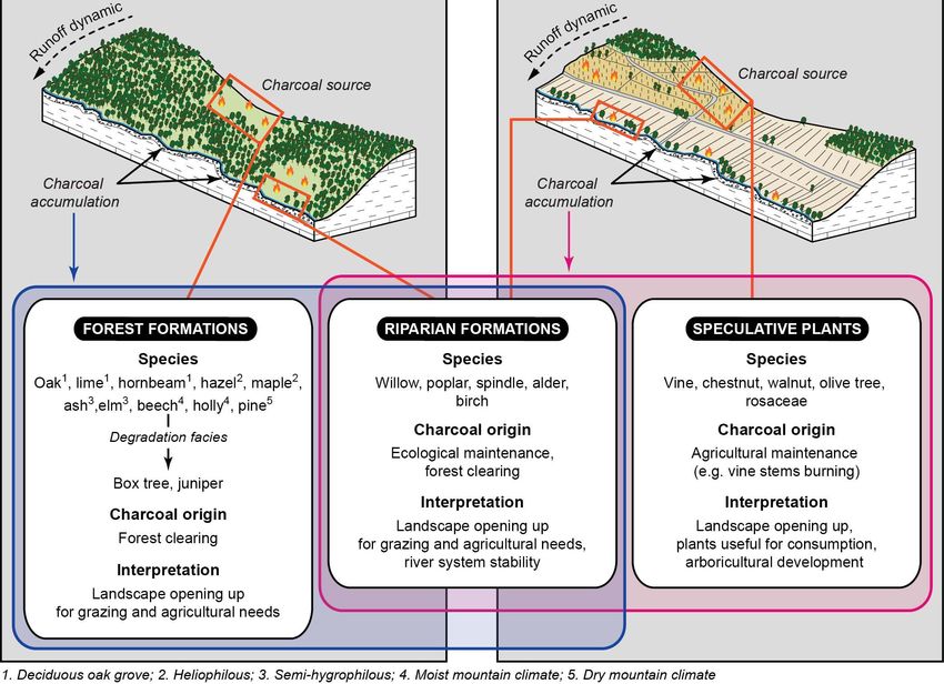
Chaize et al

environmental consequences of agricultural activities are currently           2. Study area
highly debated. While agricultural activities are commonly considered
as an environmental degradation involving an increase of soil losses            2.1. Physical settings
(Bork and Lang, 2003; van der Leeuw, 2005; Foucher et al., 2014),
many studies show that early strategies of soil erosion prevention may         We focus on the Giroux catchment (15 km²) where Mercurey
have occurred (Tarolli et al., 2014; Larsen et al., 2016). Consequently,      vineyards (640 ha) are located (Côte de Bourgogne, Burgundy,
the relationship between agricultural intensity and soil erosion is not       France). The Côte de Bourgogne (i.e., from the Côte de Nuits
necessarily linear and a debate arises to discuss whether soil erosion is
at maximum during the peak of agricultural intensity or during periods
of land abandonment. Such assumptions are based on a hypothesis of
soil maintenance strategies during the peak of agricultural activity.
  To contribute to the debate on the impact of agriculture on soil losses,
a better understanding of the links occurring between landscape
characteristics, land use change and sediment delivery is required.
One main issue is that such objective depends on past land use
spatial information (e.g., aerial imagery) to assess structural hydro-
sedimentary connectivity within catchments (Foucher et al., 2019;
Cossart et al., in press). As a consequence, available studies modelling
such interactions are often restricted to the last 40–50 years so that
studies led at larger time scales are still lacking (Lasanta et al., 2017).
  This study attempts to fill partially this gap of knowledge. We
focus here on Burgundy wine-growing area where historical studies
suggested a long tradition of soil erosion prevention: some man-made
infrastructures such as rough terraces and stony walls have been built
since the Early Middle Ages (Garcia et al., 2017a). Such infrastructures
are even often considered earlier (possibly dated from Neolithic
periods) without any direct chronological evidence (Haasé, 1977;
Harfouche, 2017). In this particular biophysical and cultural setting,
a reconstruction and subsequent interpretation of the sedimentary
signal over millennia can document the complex linkages between
land uses and erosion. In detail, geomorphic investigation would help
to reach three complementary objectives : (i) sedimentary archives
can be examined to document the evolution of soil erosion processes
within Burgundy wine-growing area during the last millennia; (ii) by
coupling geomorphologic investigations with pedoanthracological
study an evolution of land uses can be hypothesized, so that (iii) it can
complement scarce palaeoenvironmental data acquired in Burgundy
regarding vegetation cover evolution and inferring land uses during
the Holocene (Jouffroy-Bapicot, 2010; Laine et al., 2010; Argant et
al., 2011). These objectives will permit to define a qualitative model
of soil erosion at hillslope scale. Following Clark and Small (1982),
we indeed consider hillslopes as a natural system within which there
are numerous complex linkages and interactions between controlling
factors, processes and forms. Investigation at such scale is thus well
suited to illustrate what can be the complex interactions between land
uses and erosion patterns.
  The Côte Chalonnaise area and the Mercurey terroir fit well with
all of these objectives. On the one hand, during the last decades man-
made infrastructures and the evolution of land use spatial patterns           Fig. 1 - Geomorphological sketch of the Côte de Bourgogne (adapted
have directly influenced the level of soil erosion rates (Fressard et al.,    from Fressard et al., 2017).
2017; Fressard and Cossart, 2019) revealing strategies to prevent soil        1. Ante-Devonian crystalline bedrock; 2. Jurassic carbonate sedimentary cover;
                                                                              3. Quaternary alluvial deposits; 4. Main fault scarps (talus); 5. Main fault lines; 6.
erosion (Cossart et al., in press). On the other hand, this area remains      Stream of the 1st, 2nd and 3rd Strahler orders; 7. Stream of the 4th Strahler order; 8. Major
poorly documented from palaeoenvironmental point of view. Finally,            localities; 9. Spotted height.
Mercurey area has well-shaped geomorphic units in which sediment              Fig. 1 - Croquis morphostructural de la Côte de Bourgogne (modifié d’après
stores allow us to identify clear records in sedimentary archives.            Fressard et al., 2017).
                                                                              1. Socle cristallin anté-dévonien ; 2. Couverture sédimentaire carbonatée jurassique ;
  Such sediment archives are studied to draw some hypotheses on the           3. Alluvions quaternaires ; 4. Principaux escarpements de faille (talus) ; 5. Principales
coevolution of land uses and geomorphic systems to discuss to what            lignes de faille ; 6. Cours d’eau d’ordre Strahler 1, 2 et 3 ; 7. Cours d’eau d’ordre Strahler
                                                                              4 ; 8. Principales localités ; 9. Cote altimétrique.
extent some soil maintenance strategies were early applied.

  108                       Géomorphologie : relief, processus, environnement, 2021, vol. 27, n° 2, p.107-126
Coévolution du paysage géomorphologique en Bourgogne

northward to the Côte Chalonnaise southward) is a structural                                     result of frost heave during Pleistocene periglacial stages. Locally,
escarpment set on a NNE-SSW fault line that subdivides the Morvan                                some large amount of boulder and pebbly materials are observed
massif (horst) and the Saône floodplain (graben). The hillslope                                  along slide surfaces, showing that some large mass-movement may
morphology is very similar throughout the escarpment and is                                      have occurred at that time (Brenot, 2007).
characterized by an Oxfordian limestone outcrop at the top (from                                   Within the Giroux catchment area, we have selected a section
20 to 70 m high) and a well-shaped concave profile at the bottom                                 where the valley is particularly narrow, offering a direct coupling
(Oxfordian marl or marly limestones) (fig. 1). Catchment geometry                                between the valley bottom, hillslopes and plateaus. We can thus
enabled the storage of sedimentary sequences that recorded past                                  document the geomorphic evolution of a sediment cascade through
environments. The geomorphic evolution since the Late Quaternary                                 a “source-to-sink” approach. Located upstream of the Pont Latin
period generated sediments infill made of colluvial brown limestone                              pond, this valley stretch is one kilometer wide, and shows preserved
soils on the hillslopes, while the plains were mostly filled by silt                             sedimentary assemblages both on hillslopes and in valley bottom.
and clay (Mériaux et al., 1981; Campy, 2017). These colluviums are                               In detail, the hillslope is approximately 60 to 80 m high, and ranges
supplied by bedrock weathering from the sediment sources located                                 from 0.4 to 0.5 km length. The slope gradients reach 25° to 35° in
in the upper part of hillslopes and on plateaus (Ciry, 1951, 1959;                               the upper part of the hillslopes (limestone ledge), and gradually
Rat, 1953). Colluvial deposits reveal periglacial patterns such as                               decrease near the thalweg where the slope gradient is less than 3°
cryoturbation patterns (Chaline, 1976; Leneuf and Puisségur, 1976).                              (fig. 2). Commonly dried throughout the year, the Giroux valley
In many areas of Côte de Bourgogne, hillslope screes are observed at                             stretch studied may occasionally undergo major summer flash
the foot of rocky faces made of limestones and are interpreted as the                            floods.

Fig. 2 - Geomorphological sketch of the Giroux catchment (background aerial photography, IGN 2013; adapted from Fressard et al., 2017).
1. Study trench; 2. Hillslope profiles studied; 3. Limestone ledge; 4. Convex break of slope; 5. Concave break of slope; 6. Temporary streams; 7. Main streams; 8. Giroux catchment
area; 9. Sediment trap; 10. Storm basin; 11. Pond; 12. Spotted height; 13. Main faults lines; 14. Plateau surface; 15. Alluvial plain; 16. Urban area.
Fig. 2 - Croquis géomorphologique du bassin versant du Giroux (photographie aérienne en arrière-plan, IGN 2013 ; modifié d’après Fressard et al., 2017).
1. Coupe étudiée ; 2. Topo-séquences de versant étudiées ; 3. Corniche calcaire ; 4. Rupture de pente convexe (haut de versant) ; 5. Rupture de pente concave ; 6. Réseau hydrographique
intermittent ; 7. Réseau hydrographique principal ; 8. Limite du bassin versant ; 9. Bassin de décantation ; 10. Bassin d’orage ; 11. Étang ; 12. Cote altimétrique ; 13. Principales lignes
de faille ; 14. Plateau calcaire ; 15. Plaine alluviale ; 16. Zone bâtie.

  2.2. Archaeological background                                                                 fortified sites) is an indirect evidence of land use for agricultural
                                                                                                 purposes (Dubouloz et al., 2017). Findings of domestic furniture (a
  We have listed 394 archaeological sites from the Bronze Age to the                             large storage vase and a millstone) dated from the Iron Age may
Middle Ages on the Mercurey region. Protohistorical data are scanty                              be linked to technological evolutions and agricultural activities
and mainly distributed along river network, which was certainly a                                (tab. 1).
region economic driver (fig. 3A-B). Permanent occupations (e.g,                                    For the Gallo-Roman times, a significant increase of sites is

                                  Géomorphologie : relief, processus, environnement, 2021, vol. 27, n° 2, p. 107-126                                                               109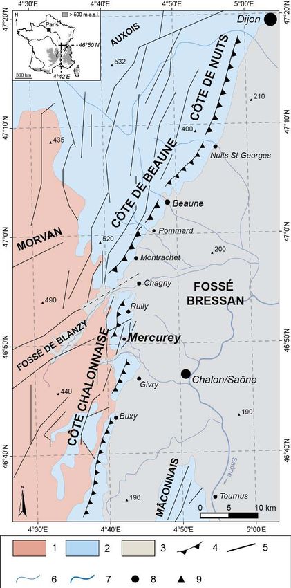
Chaize et al

                                                                                                       Fig. 3 - Archaeological sites inventory of
                                                                                                       the Mercurey region through the Late
                                                                                                       Holocene (data from SRA Bourgogne-
                                                                                                       Franche-Comté, Patriarche database,
                                                                                                       July 2020).
                                                                                                       Chronological maps are based on the frequency
                                                                                                       of archaeological sites per surface unit of
                                                                                                       500 m 2. A: Bronze Age; B.: Iron Age; C: Gallo-
                                                                                                       Roman times; D: Middle Ages. NNI: Nearest
                                                                                                       neighbour index.
                                                                                                       Fig. 3 - Recensement des sites
                                                                                                       archéologiques de la région de Mercurey
                                                                                                       au cours de l’Holocène récent (données
                                                                                                       SRA Bourgogne-Franche-Comté, base de
                                                                                                       données Patriarche, juillet 2020).
                                                                                                       Les cartes chronologiques sont basées sur la
                                                                                                       fréquence des sites archéologiques par unité de
                                                                                                       surface de 500 m2. A : Âge du Bronze ; B : Âge du
                                                                                                       Fer ; C : Époque gallo-romaine ; D : Moyen Âge.
                                                                                                       NNI : Indice du plus proche voisin.

recorded (fig. 3C). Many are located near two main roads: the first      many castles were built but also a large number of churches and
(known as the Agrippa road) connected Chalon-sur-Saône and its           monasteries were founded at the instigation of the Cluny Abbey
fluvial merchant port to the great ancient city of Autun; the second     especially, suggesting an economic and demographic growth. Local
went from Beaune to Mâcon. These roads crossed the Mercurey              laws on vine grubbing-up to reduce overproduction crisis revealed
territory. A pit silo dated to Early Roman Empire suggests land          an intensive landscape and soil management during the Late Middle
use for agricultural needs. Although there is not archaeological         Ages (Beaulant, 2018).
evidence of vine growing during this period, the Mercurey region is
located at the crossroads of numerous sites known to have provided        2.3. Holocene vegetation changes
data linked with the Gallo-Roman viticulture (wine amphora, grape
growing tools, planting pit, etc.) (Goguey, 1970; Planson, 1970;           We can describe the main stages of the regional landscape
Huygen, 1988; Vernou, 2009; Garcia et al., 2010) (fig. 4).               evolution since the beginning of the Neolithic through a synthesis of
  Compared with the previous period, the medieval sites are slightly     palynological data (Jouffroy-Bapicot, 2010; Laine et al., 2010; Argant
less numerous but better spatially distributed (fig. 3D). In detail,     et al., 2011). Such data are sometimes complemented with other
                                                                         palaeoenvironmental studies. Available data are acquired on sites
Tab. 1 - Archaeological entities of the Mercurey region (data from SRA   distributed in the Morvan massif, along the Côte de Bourgogne, in
Bourgogne-Franche-Comté, Patriarche database, July 2020).                the Saône floodplain and the Jura piedmont (fig. 5). These sites frame
Tab. 1 - Entités archéologiques de la région de Mercurey (données SRA    the study area, which enables comparison with the data produced
Bourgogne-Franche-Comté, base de données Patriarche, juillet 2020).      in this paper. Chronological sequences are here based on the major
                                                                         chronozones of the Holocene established by Mangerud et al. (1974).
                                                                           The Atlantic chronozone (7000 to 3700 cal. BC) coincides with the
                                                                         first signs of human impacts around 4900 cal. BC, as indicated by the
                                                                         emergence of cultivated species (Triticum, Hordeum, Avena) into the
                                                                         Saône floodplain and the Morvan massif (fig. 6). Their introduction
                                                                         is made possible by the clearings of a mesothermophilous forest
                                                                         composed of oak (Quercus), elm (Ulmus), ash (Fraxinus), lime (Tillia)
                                                                         and hazel (Corylus). Alder (Alnus) is the dominant species in valley
                                                                         bottoms. Herbaceous species (e.g., Plantago, Urticaceae) emerge with
                                                                         the opening of the forest for agro-pastoral needs. Taking advantage of
                                                                         cooler and wetter climatic conditions at the beginning of Subboreal
                                                                         (Haas et al., 1998; Magny and Haas, 2004; Magny, 2013), beech (Fagus)
                                                                         grows around 3500 cal. BC. It occupies a predominant proportion in
                                                                         the forest cover during the Subboreal (3700 to 800 cal. BC).
                                                                           The Subatlantic period (since 800 cal. BC) is characterized in one

 110                      Géomorphologie : relief, processus, environnement, 2021, vol. 27, n° 2, p. 107-126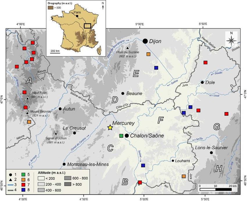
Coévolution du paysage géomorphologique en Bourgogne

                                                                                                   Fig. 4 - Gallo-Roman                   viticulture
                                                                                                   evidences in Burgundy.
                                                                                                   1. Study site; 2. Localities; 3. Main streams;
                                                                                                   4. Area undocumented; 5. Current Burgundy
                                                                                                   vineyard; 6. Grape growing tools; 7. Ecofacts
                                                                                                   (grape seeds, pollens, woody macro-remains);
                                                                                                   8. Wine amphora; 9. Planting pit; 10. Villa with
                                                                                                   vinification cellar.
                                                                                                   Fig. 4 - Indices de viticulture gallo-
                                                                                                   romaine en Bourgogne.
                                                                                                   1. Site d’étude ; 2. Localités ; 3. Principaux cours
                                                                                                   d’eau ; 4. Zone non documentée ; 5. Extension
                                                                                                   actuelle du vignoble bourguignon ; 6. Outillage
                                                                                                   viticole ; 7. Écofacts (pépins, pollens, macro-restes
                                                                                                   ligneux) ; 8. Amphore vinaire ; 9. Fosse de
                                                                                                   plantation ; 10. Villa à descente de cave.

                                                                                                   Fig. 5 - Palynological studies on the
                                                                                                   Côte de Bourgogne and its margins
                                                                                                   (Morvan massif, middle Saône valley
                                                                                                   and Jura piedmont). Studies are ordered
                                                                                                   according to the background where they
                                                                                                   have been made.
                                                                                                   1. Major localities; 2. Main mountain peaks; 3.
                                                                                                   Main streams; 4. Administrative boundaries;
                                                                                                   5. Archaeological site; 6. Swamp; 7. Peatland;
                                                                                                   8. Palaeochannel. A: Morvan massif; B:
                                                                                                   Mâconnais; C: Côte Chalonnaise; D: Côte de
                                                                                                   Beaune; E: Côte de Nuits; F: Middle Saône
                                                                                                   valley; G: Jurassian vineyard; H: Revermont /
                                                                                                   Jura plateaus.
                                                                                                   Fig. 5 - Études palynologiques sur la
                                                                                                   Côte de Bourgogne et ses marges (massif
                                                                                                   du Morvan, moyenne vallée de la Saône
                                                                                                   et piémont du Jura). Les études ont été
                                                                                                   classées selon le contexte dans lequel elles
                                                                                                   ont été réalisées.
                                                                                                   1. Principales villes ; 2. Principaux sommets ;
                                                                                                   3. Principaux cours d’eau ; 4. Limites
                                                                                                   administratives ; 5. Site archéologique ; 6.
                                                                                                   Marais ; 7. Tourbière ; 8. Paléochenal. A :
                                                                                                   Massif du Morvan ; B : Mâconnais ; C : Côte
                                                                                                   Chalonnaise ; D : Côte de Beaune ; E : Côte de
                                                                                                   Nuits ; F : Moyenne vallée de la Saône ; G :
                                                                                                   Vignoble jurassien ; H : Revermont / Plateaux
                                                                                                   du Jura.

hand by the appearance of hornbeam (Carpinus) around 800 cal. BC      piedmont during Gallo-Roman times (Gauthier, 2000; Gauthier
(Richard, 1999), and on the other hand by the introduction of new     and Joly, 2003; Garcia et al., 2010). The anthropogenic impact on
cultivated species such as walnut (Juglans) and chestnut (Castanea)   the plant assemblages and land cover has globally increased since
around 200 cal. BC. Shortly afterwards, a new speculative plant       the 6th millennium BC (Early Atlantic) and has intensified during
was cultivated: according to pollen analysis and archaeological       the Late Holocene. Around 900 cal. AD, hemp (Cannabis) and rye
data, vine (Vitis vinifera) appeared in Burgundy and the Jura         (Secale) appeared alongside traditionally cultivated cereals (wheat,

                         Géomorphologie : relief, processus, environnement, 2021, vol. 27, n° 2, p. 107-126                                   111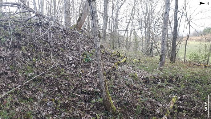
Chaize et al

Fig. 6 - Simplified synthesis of regional palaeoenvironmental data since the Neolithic.
1. Plain / hill forest; 2. Humid vegetation; 3. Dryland vegetation; 4. Cultivated plants; 5. Grassland; 6. Strong signal in regional palynological diagrams; 7. Low signal in regional
palynological diagrams. EN: Early Neolithic; MN: Middle Neolithic; LFN: Late and Final Neolithic; EB: Early Bronze Age; MB: Middle Bronze Age; LB: Late Bronze Age; HA:
Hallstatt (1st Iron Age); LT: La Tène (2nd Iron Age); ERE: Early Roman Empire; LA: Late Antiquity; G-R: Gallo-Roman period; MCP: Modern and Contemporary period.
Fig. 6 - Synthèse simplifiée des données paléoenvironnementales régionales depuis le Néolithique.
1. Forêt de plaine et de versant ; 2. Végétation humide ; 3. Végétation de milieu sec ; 4. Plantes cultivées ; 5. Végétation prairiale ; 6. Signal fort dans les diagrammes polliniques
régionaux ; 7. Signal faible dans les diagrammes polliniques régionaux. EN : Néolithique ancien ; MN : Néolithique moyen ; LFN : Néolithique récent et final ; EB : Bronze ancien ; MB :
Bronze moyen ; LB : Bronze final ; HA : Hallstatt (1er âge du Fer) ; LT : La Tène (2ème âge du Fer) ; ERE : Haut-Empire romain ; LA : Antiquité tardive ; G-R : Époque gallo-romaine ;
MCP : Époque moderne et contemporaine.

barley, oats) in the Morvan massif and floodplain area while vine                              3. Materials and methods
cultivation spreads in the Burgundian landscape (Garcia, 2014).
Concerning forest cover, from 500 cal. AD, trees tend to shrink (oak                             3.1. Identification of sedimentary facies and associated
and beech in particular). Only heliophilous species are progressing                              processes
(Pinus, Corylus, Juniperus), which reveals a transition to an open
landscape. In the Late Subatlantic, on the one hand the assemblage                               This study focuses on hillslopes considered a functional system
of trees has hardly changed, on the other hand cereal crops have                               involving complex feedbacks between biophysical processes,
become scarcer in favor of thriving prairie plants.                                            land uses and human practices. From a geomorphic field survey,
                                                                                               we detailed geomorphic components along hillslope profiles:

  112                            Géomorphologie : relief, processus, environnement, 2021, vol. 27, n° 2, p. 107-126
Coévolution du paysage géomorphologique en Bourgogne

Fig. 7 - Photographs of Pont Latin site and main sedimentary deposits studied.
A. General overview of the Pont Latin site; B. Longitudinal view of the Pont Latin trench. Note that the trench is located at the contact of the northern hillslope; C. Major
sedimentary aggradation phases from profile A of the Pont Latin trench. 1. Unsorted deposit made of angular limestone clasts (many centimeters) within a silty-clayey matrix;
2. Fine matrix (clayey silts) with roughly bedding patterns. D. Cross-section of colluvial deposits located 40 meters above the thalweg. 1. Unsorted deposit made of angular clasts
(many centimeters) within a silty-clayey matrix; 2. Fine matrix (silt and clay) with rough stratification parallel to hillslope topographic surface; 3. Wall remnant. E. Cross-section
of colluvial deposits located 30 meters above the thalweg and topped with an old dry-stone wall. (photo credit: B. Chaize, 2019 and 2020).
Fig. 7 - Photographies du site du Pont Latin et des principaux dépôts sédimentaires étudiés.
A. Vue d’ensemble du site du Pont Latin ; B. Vue longitudinale de la coupe du Pont Latin. Notez que la coupe est située au contact du versant nord ; C. Principales phases
d’aggradation sédimentaire du profil A de la coupe du Pont Latin. 1. Dépôt massif de clastes calcaires anguleux pluricentimétriques dans une matrice limono-argileuse ; 2. Matrice
fine (limons argileux) avec une structure grossièrement litée. D. Coupe transversale de dépôts colluviaux située 40 mètres au-dessus du talweg. 1. Dépôt massif de clastes anguleux
pluricentimétriques dans une matrice limono-argileuse ; 2. Matrice fine (limons argileux) avec une stratification grossière parallèle à la surface topographique ; 3. Vestige d’un mur.
E. Coupe transversale de dépôts colluviaux située 30 mètres au-dessus du talweg et surmontée par un mur de pierres sèches délabré. (crédit photographique : B. Chaize, 2019 et 2020).

topography, bedrock outcrops, sedimentary stores (e.g., material                               The framework is described in terms of shape of individual clasts (e.g.,
fabrics of surficial deposits), anthropogenic infrastructures (e.g.,                           angular, subangular, rounded). The proportions of different clast sizes
ditches, hedges, walls) and landforms at fine scale (e.g., scree,                              (e.g., sorting), and the proportion of framework corresponding to
gullies). We particularly examine sedimentary archives, from                                   matrix are also assessed. Collectively, these data provide information
which we seek to reconstruct the man/soil system and its evolution.                            on the degree of sediment reworking during transport (e.g., rounded
This examination is mostly based on the analysis of the Pont Latin                             clast following alluvial transport, angular clast following gravity-
trench located in the valley bottom, at the foot of hillslopes to which                        fed transport), and on depositional energy. For instance, larger
it is directly connected (fig. 7A-B). It was dug in 2016 to channelize                         and unsorted clasts are observed in case of higher energy processes
Giroux river seasonal floods and topographic runoff towards a storm                            involved in colluvial deposition (Bertran, 2004). Sedimentary fabric
basin and the Pont Latin pond located 300 m further downstream.                                may complement the interpretation by documenting directionality
Studied trench (approximately 150 m long) was decomposed into a                                of clasts and sediment structures. For instance, colluvial processes
series of five regularly spaced vertical profiles to follow vertically and                     such as sliding and flowing mostly generate en masse deformations,
horizontally (east-west) variations of each stratigraphic unit (fig. 7C).                      leading to diamictites without any inner clasts organization that
To complement this sedimentary data, we performed an inventory                                 contrast with better organized (stratification and sorting) materials
and a qualitative description of eight cross-sections from which we                            deposited by alluvial processes.
can observe sediment sources and sediment stores along two hillslope
profiles (fig. 7D-E).                                                                            3.2. Pedoanthracology
  Sedimentary units were described regarding their facies (structure,
texture, color) to determine the geomorphic process responsible for                             Pedoanthracology determines charcoal fragment taxa from a
their deposition (Miall, 1985). In detail, we particularly looked at the                       natural context. It can be used to give information about past woody
respective volumetric proportions of clasts that form the framework                            vegetation dynamics (Touflan et al., 2010).
(e.g., gravel, pebble, cobble) and detrital sediment that is the matrix.

                                 Géomorphologie : relief, processus, environnement, 2021, vol. 27, n° 2, p. 107-126                                                            113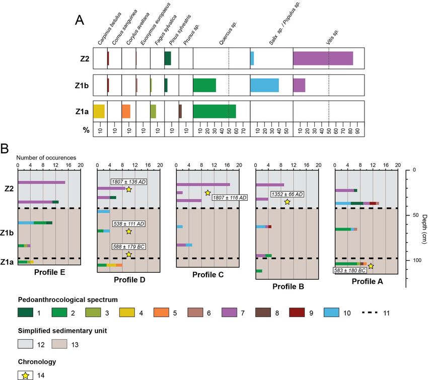
Chaize et al

   3.2.1. Inputs from pedoanthracology                                         ensure vine charcoal reveals a speculative plant, we have to check
                                                                               whether vines were located on hillslopes where Vitis sylvestris
  Charcoal have several advantages for documenting Mercurey                    cannot grow. Vine development history in Mercurey can thus
past environments. Firstly, they are a major source of information             be documented because vine is a shrub whose annual pruning
to trace wooded areas management over time because they                        provides large quantities of wood which have been burnt since
make it possible to determine woody vegetation that was burnt                  Gallo-Roman times (Amouretti, 1988). Carbonized residues may
by human societies (Dambrine et al., 2007; Dutoit et al., 2009;                be a direct marker of vine-growing over long time. Secondly,
Bal et al., 2015). In detail, charcoal may be subdivided in three              they offer a very fine spatial resolution because charcoal larger
types: charcoal from forest formations, charcoal from riparian                 than 0.4 mm (minimum size for taxonomic identification) cannot
areas and charcoal of speculative species (fig. 8). Trees from                 be transported over long distances and therefore represent local
forest covers may be burnt from either natural or anthropogenic                woody vegetation (Lynch et al., 2004; Peters and Higuera, 2007;
drivers. In that case we particularly look at the occurrence of                Dutoit et al., 2009). Thirdly, under all environmental conditions
heliophilous species that may reveal forest clearance and a                    soils preserve charcoal very well and for a long time (de
possible anthropogenically-driven maintenance in a context of                  Lafontaine and Asselin, 2011). Moreover, anthracological data
spatial extension of agriculture and grazing (Dutoit et al., 2009;             on the evolution of northern French vineyard landscapes are still
Bal et al., 2015). In riparian context, trees are often burnt to clear         very scarce (Zech-Matterne et al., 2011).
the riparian forest to have an easier access to the river. It also
enables the ecological maintenance of the river (Delhon, 2005).                     3.2.2. Analytical protocol
Charcoal of speculative plants more directly document what were
the vegetal and agricultural resources on which societies focused                Charcoal analysis follows the protocol described by Delhon
(ibid.). Chestnut or olive tree exemplifies this speculative type.             (2005). In each of the five profiles studied, a sample of eight liters
Vine charcoal may be considered either riparian (Vitis vinifera                of sediment was extracted in the middle of each sedimentary unit,
subsp. sylvestris) or speculative (Vitis vinifera subsp. vinifera). To         starting from the basal unit to avoid contamination. Moreover,

Fig. 8 - Interpretative framework of pedoanthracological data at hillslope scale.

Fig. 8 - Éléments d’interprétation des données pédoanthracologiques à l’échelle du versant.

  114                      Géomorphologie : relief, processus, environnement, 2021, vol. 27, n° 2, p. 107-126
Coévolution du paysage géomorphologique en Bourgogne
some macro-charcoal is randomly sampled on the field by taking materiel. We deleted charcoal fragments smaller than 500 µm
care to label them according to their position. In laboratory, which are too small to allow taxonomic identification. Once air-
samples were deflocculated in a hot water bath for 48 h with a dried, they were sorted under a binocular magnifier to dissociate
solution of sodium hexametaphosphate and mixed in a magnetic them from the other remains or the mineral elements present in the
agitator to break micro-aggregates. Then, charcoal were collected sieve rejects. Each fragment, previously fractured by hand, ideally
manually by systematic sieving at 2 mm and 500 µm of mixed along the three woody planes (transverse, longitudinal tangential,
Fig. 9 - Microscopic views of charcoal from the Pont Latin trench.
A: Longitudinal tangential plan of oak (Quercus sp.); B: Transverse plan of a Scots pine (Pinus sylvestris); C: Longitudinal tangential plan of vine (Vitis sp.); D: Transverse plan of
hazel (Corylus avellana). (photo credit: Chaize, 2019).
Fig. 9 - Vues microscopiques de charbons issus de la coupe du Pont Latin.
A : Plan longitudinal tangentiel de chêne (Quercus sp.) ; B : Plan transversal de pin sylvestre (Pinus sylvestris) ; C : Plan longitudinal tangentiel de vigne (Vitis sp.) ; D : Plan transversal
de noisetier (Corylus avellana). (crédit photographique : Chaize, 2019).
longitudinal radial), was identified at the finest possible taxonomic with a 99.7% confidence interval (2 s) and expressed as cal. BC/AD,
level (usually species or genus) by observation of the anatomical by using the program OxCal 4.3 and the calibration curve IntCal13
structures (fig. 9A-D). The observation was conducted under (Reimer et al., 2013).
a reflection optical microscope and by comparison with those
described in wood anatomy atlases (Schweingruber, 1990; Vernet 4. Results
et al., 2001) and charcoal from a reference collection. Identified
charcoal is reported in a counting table showing frequencies per 4.1. Sedimentary records
taxa and per profile (see section 4.2.).
4.1.1. Hillslopes
3.3. Radiocarbon dating
Two hillslope profiles have been performed from the compilation
The chronological control is based on nine Accelerator Mass of all cross-sections described on southern and northern hillslopes
Spectometry (AMS) radiocarbon dating obtained on charcoal, some of the Pont Latin site (fig. 10A-B).
of which have been identified. Radiocarbon ages were calibrated The southern hillslope is dominated by concave topography due
Géomorphologie : relief, processus, environnement, 2021, vol. 27, n° 2, p. 107-126 115Chaize et al
Fig. 10 - Hillslope profiles of the Pont Latin
site.
Superficial deposits thickness is exaggerated five
times compared to reality. A: Northern hillslope;
B: Southern hillslope; 1. Fine matrix (clayey silts)
with roughly bedding patterns; 2. Matrix-supported
diamictite with heterometric limestone clasts; 3.
“Chailles limestone” / oolithic limestone; 4. Red
oolithic limestone; 5. Pale grey marl; 6. White
marl; 7. Small bench limestone; 8. Study trench;
9. Former solifluction dynamic; 10. Hypothetical
palaeotopographic limit.
Fig. 10 - Topo-séquences des versants du site
du Pont Latin.
L’épaisseur des dépôts superficiels est exagérée cinq
fois par rapport à la réalité. A. Versant nord ; B :
Versant sud. 1. Matrice fine (limons argileux) avec
une structure grossièrement litée ; 2. Diamicton
à support matriciel riche en clastes calcaires
hétérométriques ; 3. Calcaires à chailles / calcaires
oolithiques en plaques ; 4. Calcaires oolithiques
rouges ; 5. Marnes claires ; 6. Marnes blanches ; 7.
Calcaires en petits bancs ; 8. Coupe étudiée ; 9.
Ancienne dynamique de solifluxion ; 10. Limite
hypothétique de paléotopographie.
to a marly-limestone substratum (fig. 10A), characterized by a weak
resistance to erosion, while the limestone substrate on the northern
hillslope generates steeper escarpments (fig. 10B). On the upper
part of the hillslopes, the substrate is near the surface. Superficial
deposits are very fine and characterized by cryoturbation patterns.
In the middle part of the northern hillslopes, sediment stores
indicate colluvial deposits supplied by frost heave dismantling.
In detail, the substrate is covered by an unsorted diamicton with
multi-centimeter-sized angular clasts of limestone transported by
high-energy geomorphic processes. This deposit is locally covered
by a fine layer of roughly bedded and dark brown clayey silts, typical
of low energy runoff processes. Its thickness is higher upstream
stone walls that may have acted as a sieve, trapping sediments. The Fig. 11 - Front of a solifluction lobe and drunken forest observed on the
base of the hillslopes is covered by the same silty-clayey deposits. southern hillslope of the Pont Latin site.
(photo credit: Chaize, 2020).
Along the southern hillslope, sediment stores are not extensively
visible (fig. 10B). Nevertheless, a quite large mass-movement is Fig. 11 - Front d’un lobe de solifluxion et forêt ivre identifiés sur le versant
sud du site du Pont Latin (crédit photographique : Chaize, 2020).
observed (approximately 350 m width), which front is localized
(crédit photographique : Chaize, 2020).
at the contact between footslope and the valley bottom. Its facies
is quite similar with the lower units of the Pont Latin trench (see
sections 4.1.2. and 4.1.3.). In spite of deformations due to vineyard 4.1.2. Valley bottom: profile B
infrastructures, tongue-shaped lobes are evidenced at the front of
the deposit, associated with a drunken forest (fig. 11). This type of In the valley bottom and at the contact with the northern hillslope,
forest is also observed in the source area corresponding to the upper Pont Latin trench is divided into five profiles, noted from A to E
part of the hillslope next to limestone plateau surface. (fig. 12). Each profile is between 1 and 1.20 m high and may exhibit
sediments that are provided by the northern hillslope to the valley
116 Géomorphologie : relief, processus, environnement, 2021, vol. 27, n° 2, p. 107-126Coévolution du paysage géomorphologique en Bourgogne
Fig. 12 - Stratigraphy and radiocarbon dating from profiles A to E of the Pont Latin trench.
1. Humus with roots and dark brown clayey silts; 2. Roughly bedded yellowish brown clayey silts; 3. Roughly bedded dusky red clayey silts; 4. Roughly bedded dark grayish brown
clayey silts with charcoal and small limestone clasts; 5. Matrix-supported diamictite with heterometric angular limestone clasts; 6. Matrix-supported diamictite with large angular
limestone clasts; 7. Stratigraphic correlation; 8. Lack of stratigraphic correlation; 9. Radiocarbon dating (age cal. BC/AD).
Fig. 12 - Stratigraphie et datation par le radiocarbone des profils A à E de la coupe du Pont Latin.
1. Humus à racines et limons argileux brun foncé ; 2. Limons argileux brun jaunâtre grossièrement lités ; 3. Limons argileux rouge brunâtre grossièrement lités ; 4. Limons argileux
brun grisâtre grossièrement lités avec charbons et petits clastes calcaires ; 5. Diamicton à support matriciel riche en clastes calcaires anguleux hétérométriques ; 6. Diamicton à support
matriciel riche en clastes calcaires anguleux pluricentimétriques ; 7. Corrélation stratigraphique ; 8. Absence de corrélation stratigraphique ; 9. Datation au radiocarbone (âge cal.
BC/AD).
bottom. As the bedrock could not be reached, the sequence we The first unit (from 107 to 120 cm deep) comprises multi-
observed only corresponds to the visible part of the deposits filling centimeter-sized (sometimes decimeter-sized) angular clasts of
the valley bottom at this location. limestone embedded in a dark red (2.5 YR 3/6, Munsell notation)
The profile B overlooks the thalweg by 1.20 m. It can be discriminated silty-clayey matrix (B1, Fs.6). Above this chaotic basal layer, we
in six units vertically superimposed. As it is the thickest, it constitutes find over approximately 20 cm (from 82 to 107 cm deep) a reddish
our reference profile for stratigraphic correlations and discussion. All brown (2.5 YR 4/4) silty-clayey matrix-supported diamictite made
profile units have been numbered by a facies code (tab. 2). of angular clasts of limestone slightly smaller than the previous unit
Tab. 2 - Main sedimentary facies observed on the Pont Latin trench.
The facies with an asterisk (Fs.2) refers only to the profile A described below.
Tab. 2 - Principaux faciès sédimentaires identifiés sur la coupe du Pont Latin.
Le faciès avec un astérisque (Fs.2) se réfère uniquement au profil A décrit ci-après.
Géomorphologie : relief, processus, environnement, 2021, vol. 27, n° 2, p. 107-126 117Chaize et al
(B2, Fs.5). Upward, an unsorted diamicton level is similar to the from profile B. Indeed, units D1 to D6 and C1 to C6 correspond to
basal unit but much more vertically expanded (from 40 to 82 cm units B1 to B6, whose facies are similar. However, units thickness
deep). This consists of abundant large clasts of angular limestone variations constitute a significant discrepancy. Also, profile D basal
embedded in a dark red (2.5 YR 3/6) silty-clayey matrix (B3, Fs.6). unit (D1, Fs.6) is truncated on its upstream part by the overlying unit
These first three units lacked any readily discernible sedimentary (D2, Fs.5). It thus varies from 14 to 41 cm in thickness.
structure and their upper contact is diffuse and undulating. They are
interpreted as colluvial deposits (Bertran, 2004) even if it remains 4.2. Soil charcoal assemblages
difficult to discriminate whether it corresponds to solifluction
processes or hyperconcentrated runoff. In both cases, high energy More than 170 charcoal were identified in the five profiles (tab.
processes are involved and may have reworked periglacial deposits 3). These data have been divided in three pedoanthracological
previously stored along hillslope and on plateau. phases (Z1a, Z1b and Z2) which correspond to similar taxonomic
The upper part of this profile indicates a change in sediments trends between profiles (fig. 13A-B). Dogwood (Cornus sanguinea)
grain size with the superposition of three roughly bedded units and spindle (Euonymus europaeus), which are not frequent and
quite fine, up until the summit. These latter are rich in organic difficult to ecologically discriminate, are not mentioned in the
remnants which include numerous charcoal fragments and rootlets, following development.
as well as faunal remains such as mollusc shells. From 22 to 40 cm Starting to the lower part of profiles, diagrams reveal a first
deep, we find a dark grayish brown (10 YR 4/2) matrix (B4, Fs.4). pedoanthracological phase (Z1a) with only 25 fragments (fig. 13A).
Sub-centimetric angular and subangular clasts of limestone are The assemblage consists of five tree taxa. Oak (Quercus sp.) is the
found occasionally mixed with the silt- and clay-sized sediments. main species with 60% of the determined remains (fig. 13B). In
The abundant presence of charcoal, ashes and soot that stain the this region, this species probably corresponds to pubescent oak
sediment explains its coloring. The upper contact of this unit is (Quercus pubescens), but sessile oak (Quercus petraea) presence is
sharp and delineated by dusky red (10 R 3/4) clayey silts devoid of also possible. These oak charcoal do not fit with the hydromorphic
coarse material, which is continuous for 15 cm high (B5, Fs.3). The conditions of the studied valley bottom. Consequently, they are
transition to the summit unit is diffuse over the remaining 8 cm. brought in from the peripheral hillslopes. Hornbeam (Carpinus
This upper unit is predominantly dark brown (10 YR 3/3) clayey silts betulus) and beech (Fagus sylvatica) can be associated with a
(B6, Fs.1). Underlying a fine surface vegetation mat, it is the support deciduous oak forest facies, both of which are sparse (8% and 16%
of current pedogenesis. Roots from the surface vegetation penetrate respectively). Beech is a mountain climate taxon which brings
throughout this unit. Among these last three units, B4 and B5 are a cooler/wetter tone to this forest formation. In this first phase,
interpreted as sieved runoff deposits. sediments also yielded some hazel fragments (Corylus avellana)
and a fragment of Prunus. These heliophilous trees are indicators
4.1.3. Valley bottom: profiles A, C, D and E of open areas or forest edges.
The second pedoanthracological phase (Z1b) is richer
Four other profiles surveyed on the Pont Latin trench complement (47 fragments studied) and more diversified (seven tree and shrub
data acquired on the profile B. In the same way as the reference taxa). Taxa typical of a riparian forest are identified. It encompasses
profile, profiles A, C, D and E show two phases of vertical accretion: willow (Salix sp.) or poplar (Populus sp.) which represent 40% of
(i) diamictite levels up to approximately 40 cm below the surface, and the total charcoal in this phase. Willow and poplar can hardly be
(ii) a upper part characterized by fine and roughly bedded levels more discriminated from each other from anatomical criteria and are
or less organic. grouped under the taxon Populus sp./Salix sp. Deciduous oak is
In detail, the dusky red silty-clayey unit (B5, Fs.3) is replaced on also identified with 32% of the determined fragments. The other
profile A by a yellowish brown (10 YR 5/8) silty-clayey lens from 12 to species of deciduous oak grove become scarce: beech appears
28 cm deep (A5, Fs.2). A pedogenesis phase or the post-depositional only once and hornbeam is no longer identified. Furthermore, the
processes of mineral accumulation are probably the reason for the first occurrences of vine (Vitis sp.) appear in pedoanthracological
facies coloring. sampling. Some rare fragments of Scots pine (Pinus sylvestris) were
Profile C is the only one with a sedimentary accumulation showing also found. The first two phases (Z1a and Z1b) are placed on coarse
a strictly decreasing grain size organization. It corresponds to the sedimentation units (diamicton). It could explain why embedded
transition from shattered large limestone clasts levels to increasingly charcoal in these deposits are often small (sub-millimetric).
fine levels that go richer in organic matter. This profile is locally gullied Finally, the third pedoanthracological phase (Z2) is characterised
by a lens comprising a silty-clayey matrix-supported diamictite with by a high concentration of charcoal and a considerable spectrum
heterometric angular clasts of limestone (C4, Fs.5). Its thickness depletion in favor of vine. Beyond 40 cm deep, assemblage proved
laterally decreases. It is approximately up to 25 cm in thickness on to be almost monospecific: 84% of the 104 charcoal samples
the east side but on the west side, it only reaches 10 cm. Above it, we identified are related to Vitis genus. Even if they represent only
find the unit associated with dark grayish brown clayey silts (C3, Fs.4) a small proportion of the pedoanthracocenosis, other species
described in all profiles. It vertically extends over about 20 cm. The are integrated into the reconstituted woody vegetation in this
absence in profile C of a second level of unsorted diamicton with last part. Among these, Scots pine is discrete (9%) but present in
multi-centimeter-sized angular clasts of limestone (similar to B3) is three profiles, while riparian vegetation (Salix sp./Populus sp.) only
another element of variation from the reference profile. represents 5% of the assemblage. This last phase is stratigraphically
Finally, profiles D and E do not reveal any significant difference positioned to the thinnest deposits.
118 Géomorphologie : relief, processus, environnement, 2021, vol. 27, n° 2, p. 107-126Coévolution du paysage géomorphologique en Bourgogne
Fig. 13 - Semi-quantitative results of pedoanthracological diagrams of the Pont Latin trench.
A. Relative frequency distribution per pedoanthracological phase; B. Absolute frequency distribution per profile. 1. Scots pine (Pinus sylvestris); 2. Oak (Quercus sp.); 3. Beech
(Fagus sylvatica); 4. Hornbeam (Carpinus betulus); 5 . Hazel (Corylus avellana); 6. Spindle (Euonymus europaeus); 7. Vine (Vitis sp.); 8 . Prunus (Prunus sp.); 9. Dogwood (Cornus
sanguinea); 10. Willow / Poplar (Salix sp./Populus sp.); 11. Discontinuity in pedoanthracological signal; 12. Fine matrix (clayey silts) with roughly bedding patterns; 13. Matrix-
supported diamictite with shattered limestone clasts of various size; 14. Radiocarbon dating (age cal. BC/AD).
Fig. 13 - Résultats semi-quantitatifs des analyses pédoanthracologiques de la coupe du Pont Latin.
A. Répartition des fréquences relatives par phase pédoanthracologique ; B. Répartition des fréquences absolues par profil. 1. Pin sylvestre (Pinus sylvestris) ; 2. Chêne (Quercus sp.) ; 3.
Hêtre commun (Fagus sylvatica) ; 4. Charme commun (Carpinus betulus) ; 5. Noisetier commun (Corylus avellana) ; 6. Fusain d’Europe (Euonymus europaeus) ; 7. Vigne (Vitis sp.) ;
8. Prunus (Prunus sp.) ; 9. Cornouiller sanguin (Cornus sanguinea) ; 10. Saule/Peuplier (Salix sp./Populus sp.) ; 11. Discontinuité dans le signal pédoanthracologique ; 12. Matrice
fine (limons argileux) avec une structure grossièrement litée ; 13. Diamicton à support matriciel riche en clastes calcaires anguleux de taille variée ; 14. Datation au radiocarbone
(âge cal. BC/AD).
4.3. Chronology limits of radiocarbon scope (tab. 4). The dated elements certainly
correspond to old charcoal resulting from natural fires, or to
Radiocarbon dating provides a chronological framework inorganic charcoal (lignite) whose presence is abundant in the
of approximately 2,700 years and a terminus post quem for sedimentary records studied.
the genesis of the geomorphological dynamics identified. Samples location is described from their belonging to
Indeed, geomorphic processes reworked charcoal that has been sedimentological units and pedoanthracological phases in the
previously burnt. The ages of three samples were rejected because studied profiles. Three dates are acquired throughout profile D,
they are very close to (PLPE2) or beyond (PLPB2 and PLPB3) the providing the best chronological constraint of the sequence. At
Géomorphologie : relief, processus, environnement, 2021, vol. 27, n° 2, p. 107-126 119Chaize et al Tab. 3 - Charcoal fragment count per taxa and per profile. Tab. 3 - Nombre de fragments de charbon par taxon et par profil. Tab. 4 - Radiocarbon dating obtained on the Pont Latin trench. Tab. 4 - Datations par le radiocarbone obtenues sur la coupe du Pont Latin. The samples with an asterisk were rejected because their ages are very close to or went over the radiocarbon dating capacity. Unidentified charcoal corresponds to a preliminary study preceding the launch of the current research project. Les échantillons avec un astérisque ont été écartés parce que leurs âges sont très proches ou au-delà de la portée pratique du radiocarbone. Les charbons non identifiés correspondent à une étude préliminaire précédant le lancement du projet de recherche actuel. 120 Géomorphologie : relief, processus, environnement, 2021, vol. 27, n° 2, p. 107-126
Coévolution du paysage géomorphologique en Bourgogne

the bottom, the diamicton unit with dark red silty-clayey matrix         the northern hillslope. As the study trench base does not reach
(D1) yields an age of 588 ± 179 cal. BC consistent with the First        the bedrock, previous sedimentary dynamics (i.e., from the Late
Iron Age. This date performs on an unspecified charcoal but              Pleistocene to 800 cal. BC) remain unknown. Then, the grain size
which belongs to the pedoanthracological phase dominated                 of unit B2 indicates that these high-energy geomorphic processes
by Quercus taxa (Z1a). It may therefore be tens or hundreds of           occurred after the transition between the Late Antiquity and the
years older than the matrix from which it is recovered. Another          Early Middle Ages. Indeed, stratigraphically correlated to unit
charcoal, sampled in the middle part of the overlying coarse unit        B2, unit D2 provides a historical anchorage at 538 ± 111 cal. AD.
(D2, Z1b), refers to the transition between the Late Antiquity           Finally, this phase of coarse sedimentation includes unit B3 and
and the Early Middle Ages (538 ± 111 cal. AD). The interface             interrupts before the Central Middle Ages (1352 ± 66 cal. AD) with
between the dark grayish brown silty-clayey unit (D4, Z2) and            dark grayish brown clayey silts deposition (B4). A time gap during
the dusky red silty-clayey unit (D5, Z2) indicates an age of             the Gallo-Roman period is noticed, probably due to a river incision
1807 ± 136 cal. AD and can be attributed to the Modern and               or too high radiocarbon ages related to the “old wood effect”.
Contemporary periods.                                                    Considering the micro-regional scope of this sedimentary hiatus
  Only one date has been acquired from profile A. It comes from          (Garcia et al., 2008), the first hypothesis is favoured. Additional
the top of the diamicton unit with a red dark silty-clayey matrix        sedimentary records within the Giroux catchment are currently
(A1) and belongs to the lower pedoanthracological phase (Z1a). It        being studied to resolve this issue.
gives an age of 583 ± 180 cal. BC, corresponding to the First Iron         If we consider landscape evolution, diamicton units intersect
Age. Derived from an oak charcoal, it may also be subject to the         two woody formations. The first one (Z1a) is a deciduous forest
“old wood effect”.                                                       composed of oak (Quercus sp.), hazel (Corylus avellana), beech
  On profile B, an age (1352 ± 66 cal. AD) acquired from the             (Fagus sylvatica) and hornbeam (Carpinus betulus). It certainly
base of the dark grayish brown clayey silts (B4, Z2) suggests            grows on the peripheral hillslopes of the Pont Latin trench.
a sedimentary deposit latter than the Central Middle Ages.               Discreetly present in this first phase, beech demonstrates the forest
On profile C, the top of this same unit (C3, Z2) reveals an age          maturity (Robin et al., 2013) and the climate humidity (Delhon,
(1807 ± 116 cal. AD) related to the Modern and Contemporary              2005). These climatic conditions contributed to high-energy
periods.                                                                 geomorphic processes. It could coincide with the cooler and wetter
  Most of the dates we obtained are located on radiocarbon               period of the First Iron Age (Haas et al., 1998; Magny, 2004). The
plateaus. This leads to inaccuracies, generally greater than             over-representation of oak taxa in charcoal assemblages during
100 years cal. BC/AD. Extended general chronological frame can           this protohistoric period is consistent with the results of regional
nevertheless be discussed.                                               palaeoenvironmental analyses (Jouffroy-Bapicot, 2010; Laine et al.,
                                                                         2010; Argant et al., 2011). The identification of a heliophilous taxon
5. Discussion                                                            such as hazel suggests a sparse forest (Bégeot, 2013). The presence of
                                                                         an open forest is in accordance with the hillslope dynamics and may
  Mercurey geomorphic evolution is characterized by two major            have predisposed such processes. The pedoanthracological signal
changes in terms of sedimentary signal, the hinge of which remains       also allows us to identify the emergence of anthropogenic land uses,
to be precisely dated (fig. 14A-B). The chronological boundaries of      especially landscape opening, probably for agro-pastoral needs as
the two phases are given in the broadest possible way. We draw here      suggested by archaeological data (see section 2.2.).
some hypotheses to interpret the variability of such signal thanks to      The second formation (Z1b) is representative of a riparian forest
pedoanthracological data and regional correlations.                      and suggests an ecological maintenance or exploitation of the
                                                                         alluvial lands near the study site (Delhon, 2005). According to
 5.1. Phase 1: High-energy geomorphic processes in an                    the age of 538 ± 111 cal. AD, such practices occurred during the
 opening forest landscape.                                               transition between the Late Antiquity and the Early Middle Ages.
                                                                         Concerning vine occurrences within this first detritism phase, it
  This first phase covers a very broad period at least from 800 cal.     is not possible to distinguish between its wild and domestic forms.
BC to 1400 cal. AD. It includes the basal diamicton unit (B1) which      Wild vine (Vitis sylvestris) could be suggested by the abundance
yields an age related to the First Iron Age on profiles A and D. This    of riparian taxa (Salix sp./Populus sp.) as the riparian forest is an
unit seems to reflect the valley bottom filling by materials supplied    environment in which wild vine naturally grows (Gauthier, 2000).
from frost heave screes (from limestone ledges sources) accumulated      However, domestic vine (Vitis vinifera) cannot be dismissed due to
during Pleistocene and transported by colluvial processes at least       the chronological limits of the first phase. They include the Gallo-
from 800 cal. BC (fig. 14A). During Pleistocene, seasonal freezing       Roman period where vine was introduced in Burgundy (Garcia et
and thawing in the Burgundian periglacial environments caused            al., 2010).
intense disintegration of the limestone ledges (Ciry, 1951, 1959; Rat,
1953; Campy, 2017), providing sediments to the stores located along       5.2. Phase 2: Controlled geomorphic processes in a wine-
hillslopes. During the Holocene warmer periods that followed,             growing landscape
such sediment stores (e.g., screes) were reworked through colluvial
processes requiring large amount of water and revealing slope             The coarse grain deposition phase is replaced by an accumulation
instability. The occurrence of a mass-movement on the southern           of fine and roughly bedded sediments after 1400 cal. AD. All profiles
hillslope suggests the hypothesis of solifluction processes along        of the Pont Latin trench and sediment stores along hillslopes record

                          Géomorphologie : relief, processus, environnement, 2021, vol. 27, n° 2, p. 107-126                            121
Vous pouvez aussi lire