Background Document on the Charlie-Gibbs Fracture Zone
←
→
Transcription du contenu de la page
Si votre navigateur ne rend pas la page correctement, lisez s'il vous plaît le contenu de la page ci-dessous
Background Document on the Charlie-Gibbs
                      Fracture Zone
Biodiversity Series

                                                                 2010
OSPAR Convention                                     Convention OSPAR
The Convention for the Protection of the             La Convention pour la protection du milieu
Marine Environment of the North-East Atlantic        marin de l'Atlantique du Nord-Est, dite
(the “OSPAR Convention”) was opened for              Convention OSPAR, a été ouverte à la
signature at the Ministerial Meeting of the          signature à la réunion ministérielle des
former Oslo and Paris Commissions in Paris           anciennes Commissions d'Oslo et de Paris,
on 22 September 1992. The Convention                 à Paris le 22 septembre 1992. La Convention
entered into force on 25 March 1998. It has          est entrée en vigueur le 25 mars 1998.
been ratified by Belgium, Denmark, Finland,          La Convention a été ratifiée par l'Allemagne,
France, Germany, Iceland, Ireland,                   la Belgique, le Danemark, la Finlande,
Luxembourg, Netherlands, Norway, Portugal,           la France, l’Irlande, l’Islande, le Luxembourg,
Sweden, Switzerland and the United Kingdom           la Norvège, les Pays-Bas, le Portugal,
and approved by the European Community               le Royaume-Uni de Grande Bretagne
and Spain                                            et d’Irlande du Nord, la Suède et la Suisse
                                                     et approuvée par la Communauté européenne
                                                     et l’Espagne

Acknowledgement
This report was originally commissioned by Stephan Lutter, WWF, and prepared by Dr Sabine
Christiansen as a contribution to OSPAR’s work on MPAs in areas beyond national jurisdiction. The
report has subsequently been developed further by the OSPAR Intersessional Correspondence Group
on Marine Protected Areas led by Dr Henning von Nordheim (German Federal Agency for Nature
Conservation/BfN) taking into account reviews by Prof. Callum Roberts, Beth O’Leary and Rachel
Brown of the University of York as commissioned by BfN Germany and a review by ICES. The
contributions of the following are also acknowledged: Richard Emmerson, Jeff Ardron, Tim Packeiser.
Contents
Executive summary ...............................................................................................................................4
Récapitulatif ...........................................................................................................................................4
A.          General information .................................................................................................................6
      1.      Area .........................................................................................................................................6
      2.      Conservation Objectives..........................................................................................................6
            2.1     Conservation Vision .........................................................................................................6
            2.2     General Conservation Objectives ...................................................................................6
            2.3     Specific Conservation Objectives ....................................................................................7
      3.      Status of the location ...............................................................................................................8
      4.      Marine region ...........................................................................................................................8
      5.      Biogeographic region ...............................................................................................................8
      6.      Location ...................................................................................................................................8
      7.      Size ........................................................................................................................................10
      8.      Characteristics of the area.....................................................................................................10
Demersal (benthopelagic) fish fauna ................................................................................................17
B.       Selection criteria .....................................................................................................................19
      1.   Ecological criteria/considerations ..........................................................................................19
         1.1    Threatened and/or declining species and habitats ........................................................19
         1.2    Important species and habitats......................................................................................22
         1.3    Ecological significance ..................................................................................................23
         1.4    High natural biological diversity .....................................................................................24
         1.5    Representativity .............................................................................................................25
         1.6    Sensitivity.......................................................................................................................26
         1.7    Naturalness....................................................................................................................32
      2.   Practical criteria/considerations .............................................................................................34
         2.1    Potential for restoration .................................................................................................34
         2.2    Degree of acceptance ...................................................................................................35
         2.3    Potential for success of management measures ..........................................................36
         2.4    Potential damage to the area by human activities.........................................................36
         2.5    Scientific value ...............................................................................................................38
C.       Management Issues ...............................................................................................................39
      1.   Human activities ....................................................................................................................39
      2.   Any existing or proposed legal status ....................................................................................39
         2.1   National legal status (e.g., nature reserve, national park): ............................................39
         2.2   Other international legal status (e.g., NATURA 2000, Ramsar):...................................39
References ...........................................................................................................................................40
Annex 1 .................................................................................................................................................50
   Species and habitats of special interest for the proposed CGFZ-MPA ..........................................50

                                                                                                                                                           3
Background Document on the Charlie-Gibbs Fracture Zone

Executive summary
The Charlie-Gibbs Fracture Zone represents an especially complex section of the Mid-Atlantic Ridge
between Iceland and the Azores, with three main features. The Mid Atlantic Ridge with its many peaks
rises to summits shallower than 1500 m depth and provides the benthic fauna with the only hard
substrate at relatively shallow depths in the North Atlantic open ocean. The major fracture zone in the
area, the Charlie-Gibbs Fracture Zone, offsets the ridge by 5° to the east, opening a deep sea
connection between the north-west and north-east Atlantic. In the water column cold Arctic and warm
Atlantic waters create a permanent oceanographic feature, the meandering sub polar front, which
separates the different faunal communities of the warm and the cold waters to the north and south of
the front. The increased bioproductivity at the front attracts migratory species, such as whales and
seabirds. The area is a major biogeographic east-west and north-south divide for deep sea species,
and hosts seamount communities, with cold-water corals and deep sea sponges, and seamount-
aggregating benthopelagic fishes such as roundnose grenadier, orange roughy and redfish.

In 2003, the OSPAR Commission agreed to establish a network of Marine Protected Areas (MPAs)
with the aim that this should become an ecologically coherent network of well-managed sites. OSPAR
agreed that the OSPAR Network of MPAs should comprise sites that are established as MPAs within
the jurisdiction of OSPAR Contracting Parties as well as sites in the maritime area outside the
jurisdiction of the Contracting Parties (area beyond national jurisdiction (ABNJ)). In the OSPAR
Biodiversity and Ecosystems Strategy, OSPAR agreed to identify, on the basis of reports from
Contracting Parties and observer organisations, possible components of the OSPAR Network in ABNJ
in order to achieve the purposes of the network.

This background document makes available the information which has been compiled and evaluated
within the OSPAR framework on the biodiversity and ecosystems of a section of the Charlie-Gibbs
Fracture Zone and the adjacent sections of the Mid-Atlantic Ridge, which was proposed to OSPAR as
a potential MPA in ABNJ in 2008. On the basis of this information, the 2010 Ministerial Meeting of the
OSPAR Commission adopted OSPAR Decision 2010/2 on the establishment of the Charlie-Gibbs
South MPA and agreed on work within the framework of OSPAR to resolve outstanding issues with
regard to the high seas of the northern part of the Charlie-Gibbs Fracture Zone area.

This document also includes conservation objectives developed within the OSPAR framework for
application to an MPA in the area of the Charlie-Gibbs Fracture Zone which have been formalised in
OSPAR Recommendation 2010/13 on the management of the Charlie-Gibbs South MPA.

Récapitulatif
La zone de fracture Charlie-Gibbs représente une partie particulièrement complexe de la dorsale
médio-atlantique, située entre l’Islande et les Açores, comportant trois caractéristiques principales. La
dorsale médio-atlantique comporte de nombreux pics, ses sommets se situent à moins de 1500 m de
profondeur et offrent à la faune benthique le seul substrat dur à des profondeurs relativement faibles
en plein océan Atlantique Nord. La principale zone de fracture dans cette zone, la zone de fracture
Charlie-Gibbs, compense la dorsale de 5° à l’est, ouvrant une faille en eaux profondes permettant une
connexion majeure entre l’Atlantique du Nord-Ouest et l’Atlantique du Nord-Est. Les eaux froides de
l’Arctique et les eaux plus chaudes de l’Atlantique créent dans la colonne d’eau une caractéristique
océanographique permanente. Il s’agit du front subpolaire sinueux qui sépare les diverses
communautés faunales des eaux chaudes et des eaux froides au nord et au sud du front. La
bioproductivité accrue au front attire des espèces migratrices telles que les baleines et les oiseaux de

4
OSPAR Commission, 2010

mer. Cette zone représente une division biogéographique majeure est-ouest et nord-sud pour les
espèces d’eaux profondes et héberge des communautés de monts sous-marins telles que les coraux
d’eau froide et les éponges d’eau profondes ainsi que des poissons bentopélagiques s’agrégeant sur
les monts sous-marins tels que le grenadier de roche, l’hoplostète orange et le sébaste.

La Commission OSPAR est convenue, en 2003, de créer un réseau de zones marines protégées
(ZMP) afin que celui-ci devienne un réseau de sites écologiquement cohérent et bien géré. OSPAR
est convenue que le réseau OSPAR de ZMP devra englober les sites créés à titre de ZMP situés dans
la juridiction des Parties contractantes OSPAR ainsi que les sites de la zone maritime situés au-delà
de la juridiction des Parties contractantes (zone au-delà de la juridiction nationale (ABNJ)). OSPAR
est convenue, dans sa Stratégie biodiversité et écosystèmes, de déterminer, en se fondant sur des
rapports des Parties contractantes et d’organisations observatrices, des composantes éventuelles du
réseau OSPAR situées dans des zones au-delà de la juridiction nationale afin de parvenir aux
objectifs du réseau.

Le présent document de fond comporte les informations qui ont été recueillies et évaluées dans le
cadre de travail d’OSPAR et portant sur la biodiversité et les écosystèmes d’une partie de la zone de
fracture Charlie-Gibbs et des parties adjacentes de la dorsale médio-atlantique, qui a été proposée à
OSPAR à titre de ZMP potentielle dans une ABNJ en 2008. La réunion ministérielle de 2010 de la
Commission OSPAR a adopté, en se fondant sur ces informations, la Décision OSPAR 2010/2 sur la
création de la ZMP Charlie-Gibbs méridionale et est convenue des travaux à entreprendre dans le
cadre de travail d’OSPAR afin de résoudre les questions en suspens relatives à la haute mer de la
partie septentrionale de la zone de fracture Charlie-Gibbs.

Le présent document comporte également des objectifs de conservation développés au sein du cadre
de travail d’OSPAR à appliquer à une ZMP située dans la zone de fracture Charlie-Gibbs, objectifs qui
ont été officialisés dans la Recommandation OSPAR 2010/13 sur la gestion de la ZMP Charlie-Gibbs
méridionale.

                                                                                                   5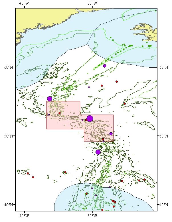
Background Document on the Charlie-Gibbs Fracture Zone

A. General information
1.    Area
Charlie-Gibbs Fracture Zone

2.    Conservation Objectives
2.1   Conservation Vision1
“Maintenance and, where appropriate, restoration of the integrity and natural quality of the functions
and biodiversity of the various ecosystems of the Charlie-Gibbs Fracture Zone so they are the result of
natural environmental quality and ecological processes.2”

Cooperation between competent authorities, stakeholder participation, scientific progress and public
learning are essential prerequisites to realize the vision and to establish a Marine Protected Area
subject to good governance, sustainable utilization, and adequate regulations, in conformity with
UNCLOS. Best available scientific knowledge and the precautionary principle form the basis for
conservation.

2.2   General Conservation Objectives3 4
      (1)     To protect and conserve the range of habitats and ecosystems including the water
              column of the Charlie-Gibbs Fracture Zone for resident, visiting and migratory species as
              well as the marine communities associated with key habitats;

      (2)     To prevent loss of biodiversity, and promote its recovery where practicable, so as to
              maintain the natural richness and resilience of the ecosystems and habitats;

      (3)     To prevent degradation of, and damage to, species, habitats and ecological processes,
              in order to maintain the structure and functions - including the productivity - of the
              ecosystems;

      (4)     To restore the naturalness and richness of key ecosystems and habitats, in particular
              those hosting high natural biodiversity;

      (5)     To provide a refuge for wildlife within which there is minimal human influences and
              impact.

1
      The conservation vision describes a desired long-term conservation condition and function for the ecosystems in the
      entire Charlie-Gibbs Fracture Zone. The vision aims to encourage relevant stakeholders to collaborate and contribute to
      reach the objectives set for the area.
2
      Recognizing that species abundances and community composition will change over time due to natural processes.
3
      Conservation objectives are meant to realize the vision. Conservation objectives are related to the entire Charlie-Gibbs
      Fracture Zone or, if it is decided to subdivide, for a zone or subdivision of the area, respectively.
4
      It is recognized that climate change may have effects in the area, and that the MPA may serve as a reference site to
      study these effects.

6
OSPAR Commission, 2010

2.3   Specific Conservation Objectives5
      2.3.1. Water Column
              a.      To prevent deterioration of the environmental quality of the bathypelagic and
                      epipelagic water column (e.g. toxic and non-toxic contamination6) from levels
                      characteristic of the ambient ecosystems;
              b.      To prevent other physical disturbance (e.g. acoustic);

              c.      To protect, maintain and, where in the past impacts have occurred, restore where
                      appropriate the epipelagic and bathypelagic ecosystems, including their functions
                      for resident, visiting and migratory species, such as: cetaceans, and mesopelagic
                      and bathypelagic fish populations.

      Special attention should be given to the area of the meandering sub-polar frontal ecosystem.

      2.3.2. Benthopelagic Layer

      To protect, maintain and, where in the past impacts have occurred, restore where appropriate:
              a.      Historically harvested fish populations (target and bycatch species) at/to levels
                      corresponding to population sizes above safe biological limits7 with special
                      attention also given to deep water elasmobranch species, including threatened
                      and/or declining species, such as Portuguese dogfish, Leafscale gulper shark and
                      Gulper shark;
              b.      Benthopelagic habitats and associated communities.

      2.3.3. Benthos

      To protect, maintain and, where in the past impacts have occurred, restore where appropriate:

              a.      The epibenthos and its hard and soft sediment habitats, including threatened
                      and/or declining species and habitats such as seamounts, deep-sea sponge
                      aggregations, Lophelia pertusa reefs and coral garden;
              b.      The infauna of the soft sediment benthos, including threatened and/or declining
                      species and habitats;
              c.      The habitats associated with ridge structures.

      2.3.4. Habitats and species of specific concern

      Those species and habitats of special interest for the Charlie-Gibbs Fracture Zone, which could
      also give an indication of specific management approaches, are listed at Annex 1.

5
      Specific Conservation Objectives shall relate to a particular feature and define the conditions required to satisfy the
      general conservation objectives. Each of these specific conservation objectives will have to be supported by more
      management oriented, achievable, measurable and time bound targets.
6
      This includes synthetic compounds (e.g. PCBs and chemical discharge), solid synthetic waste and other litter (e.g.
      plastic) and non-synthetic compounds (e.g. heavy metals and oil).
7
      “Safe biological limits” used in the following context: “Populations are maintained above safe biological limits by ensuring
      the long-term conservation and sustainable use of marine living resources in the deep-seas and preventing significant
      adverse impacts on Vulnerable Marine Ecosystems (FAO International Guidelines for the Management of Deep-Sea
      Fisheries in the High Seas, 2008).

                                                                                                                                7
Background Document on the Charlie-Gibbs Fracture Zone
3. Status of the location
The area described in this background document was designed to be located beyond the limits of
national jurisdiction of the coastal states in the OSPAR Maritime Area.
On 29 April 2009 the Republic of Iceland submitted to the UN Commission on the Limits of the
Continental Shelf, information on the limits of the Icelandic continental shelf in the area of the
Reykjanes ridge beyond 200 nautical miles from the baselines from which the breadth of the territorial
sea is measured, in accordance with Article 76, paragraph 8, of the Convention of the Law of the Sea.
The limits submitted by Iceland – if approved by the Commission - would encompass the seabed in
part of the area of the area described in this background document.
The international legal regime that is applicable to the site is comprised of, inter alia, the UNCLOS, the
Convention on Biological Diversity, the OSPAR Convention and other rules of international law. This
regime contains, among other things, rights and obligations for states on the utilization, protection and
preservation of the marine environment and the utilization and conservation of marine living resources
and biodiversity as well as specifications of the competence of relevant international organizations.
4. Marine region
OSPAR Region V; Mid-Atlantic Ridge
5. Biogeographic region
Atlantic sub region; Cool-temperate waters; Warm temperate waters.
6. Location
The area described in this background document covers the northern part of the Mid-Atlantic Ridge,
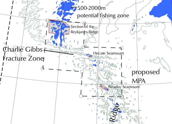
including the Charlie-Gibbs Fracture and Maxwell Fracture Zones (see Figure 1). The area includes
the seamounts Faraday (1251 km2) and Hecate (358 km2), and corresponds broadly to the Middle
MAR area where the use of fishing gear likely to contact the seafloor during the course of normal
fishing operations has been prohibited since 2009 until presently 31st December 2015 (NEAFC
Recommendation on the protection of vulnerable marine ecosystems from significant adverse impacts
in the NEAFC regulatory area, 2009). The area described is slightly larger than the current NEAFC
closures, with the purpose to represent a coherent area that includes all of the relevant biogeographic
regions and a wide range of habitats, as well as countering the general lack of knowledge about deep-
sea habitats by implementing the Precautionary Principle.
The coordinates originally proposed for the boundaries of an MPA in the area of the Charlie-Gibbs
Fracture Zone8 are:
Latitude N Longitude W
55o 37.o W
55o 32o W
53.5o 32o W
53.5o 27o W
49o 27o W
49o 32o W
51o 32o W
51o 37o W
55o 37o W
8
For boundary coordinates of the Charlie-Gibbs South MPA see OSPAR Decision 2010/2
8
OSPAR Commission, 2010

These boundaries reflect a scientific agreement reached at OSPAR’s Intersessional Correspondence
Group MPA in April 2008 that the enclosed area will fully incorporate representative sections of the
MAR north and south of the Charlie-Gibbs Fracture Zone, and the meandering subpolar front that
separates cool northern from warmer southern waters and sustains a relatively high abundance and
biomass across the food web. The subpolar front, usually lies just south of the Charlie-Gibbs Fracture
Zone, but varies in position. The boundaries incorporate also a variety of seamount communities of
different sizes and depths, including Faraday and Hecate, as well as three deep east-west trenches,
the fracture zones. Overall, the summit depth of the MAR peaks increases from north to south.

In many forums deep-water fishing is described as that which occurs deeper than 400 m. Therefore,
within the Charlie-Gibbs fracture Zone, areas have been mapped that can be potentially fished from
500 m to 2000 m (Fig. 2). 2000m delimits the maximum fishing depth of the predominant past and
present fishing activities. This is quite a narrow area and most fishing on the MAR concentrates on the
depths of less than 1000m on the tops and slopes of the shallower hills (Bergstad, O.A. pers comm.).

     Figure 1. Location of the proposed Charlie-Gibbs Fracture Zone MPA on the Mid-Atlantic Ridge. The
     NEAFC closures within the proposed area between 2005 and 2009 are outlined in red (Hecate,
     Faraday Seamounts and Reykjanes Ridge). A much larger area, the Middle MAR, was closed to
     bottom fishing by NEAFC in 2009, corresponding more closely to the CGFZ.

                                                                                                         9
Background Document on the Charlie-Gibbs Fracture Zone

     Figure 2. The fishable area within the proposed CGFZ MPA on the Mid-Atlantic Ridge (in blue). The
     NEAFC closures (2005-2009) are outlined in red (Hecate, Faraday Seamounts and Reykjanes
     Ridge).

7.    Size
323 900 km2

8.    Characteristics of the area
The Mid-Atlantic Ridge (MAR) is the major topographic feature of the Atlantic Ocean extending within
the OSPAR Maritime Area, from the Lomonossov Ridge in the Arctic Ocean to its southern boundary.
The MAR is a slow-spreading ridge where new oceanic floor is formed, and western and eastern parts
of the North Atlantic basin spread at a speed of 2-6 cm/year (Dinter, 2001; Heger et al., 2008; Hosia et
al., 2008). Its shallower part is found south of Iceland towards the Azores, both groups of islands being
the top of ridge-associated seamounts. Rising from bathyal and abyssal depths, the Mid-Atlantic Ridge
dominates the seafloor topography in the High Seas of the OSPAR region. The topography is highly
differentiated with depths ranging from 4500 m in the deepest channel to only 700-800 m on top of
adjacent seamounts (Dinter, 2001).

The relief of the axial part of the MAR is presented by systems of separated volcanic rocky mountains.
More than 170 seamounts with summit depths less than 1500 metres were found in the northern part
of the MAR between 43° and 60°N during Russian explorations in 1972-1984 (Shibanov et al., 2002).
The majority of seamounts are concentrated in the central (rift) zone of the ridge and in the zone of the
transversal (transformed) cracks. Intermountain slashes and smooth slopes are covered with irregular
granular sand aleurite, silt, coral, shelly and benthos detritus (Shibanov et al., 2002 and literature
therein). With its deep, sometimes abyssal valleys and intermittent shallow hills and islands, the ridge
can be compared to a mountain chain on land. Apart from the rocky and mountainous areas, there are
extensive areas of soft sediment (Feller et al., 2008) in particular at greater depth.

Ecologically, ridges are fundamentally different from both isolated seamounts surrounded by deep
ocean and from continental slopes where effects of coastal processes are pronounced. They affect not
only the availability of suitable habitats for benthic or benthopelagic species, but the topography
strongly shapes also the habitat characteristics in the water column through modification of currents
and production patterns (see e.g. Opdal et al., 2008). The Mid-Atlantic Ridge has a profound role in

10
OSPAR Commission, 2010
the circulation of the water masses in the North Atlantic (Rossby, 1999; Bower et al., 2002; Heger et
al., 2008; Søiland et al., 2008). The complex hydrographic setting around the Mid-Atlantic Ridge in
general and the presence of the ridge itself leads to enhanced vertical mixing and turbulence that
results in areas of increased productivity over the MAR (Falkowski et al., 1998; Heger et al., 2008; for
a more detailed description see the Ecological Significance criterion B3 below). Despite generally
limited surface production, there is evidence of enhanced near ridge demersal fish biomass above the
Mid-Atlantic Ridge (Fock et al., 2002; Bergstad et al., 2008) and that the mid-ocean ridges are
ecologically important for higher trophic levels relative to the surrounding abyssal plains and the open
ocean (e.g., blue ling and roundnose grenadier spawning aggregations on the northern MAR
(Magnusson & Magnusson 1995, Vinnichenko & Khlivnoy 2004).
The proposed MPA covers an especially complex section of the Mid-Atlantic Ridge (Søiland et al.,
2008) and as such is expected to be home to diverse and interesting deep-sea fauna (Tabachnick &
Collins, 2008). From the north, the Reykjanes Ridge stretches south-westwards from Iceland to
approximately 52°N, where a major fracture zone known as the Charlie-Gibbs Fracture Zone (Felley et
al., 2008; Heger et al., 2008) offsets the ridge by 5o to the east and opens the deepest (maximum
depth 4500 m) connection between the northwest and northeast Atlantic (Felley et al., 2008; Heger et
al., 2008; Mortensen et al., 2008; Søiland et al., 2008). South of the Charlie-Gibbs Fracture zone, two
pronounced deep rift valleys at 32.25°W and 31.75°W (Opdal et al., 2008) and two further fracture
zones (Faraday and Maxwell Fracture Zones, at 50°N and 48°N respectively) create an enormous
topographic – and fairly unknown – ecological complexity.
The general circulation in the epipelagic zone (0-200 m) is well understood as the warm North Atlantic
current flowing north-eastwards from the subtropical gyre in the southwest Atlantic towards the
European shelf with two to four branches crossing the MAR between 45° and 52° N, approximately
coinciding with the three fracture zones (Sy et al., 1992, Søiland et al., 2008). Where the warm, saline
North Atlantic water meets the cold, less saline water of the subpolar gyre from the Labrador and
Irminger Seas, the subpolar front is a permanent feature (Figure 2). The meandering of the subpolar
front between 48-53°N coincides with temporal variation in the character and spatial distribution of the
watermasses and frontal features (Søiland et al., 2008). This front is one of the major oceanic
features in the OSPAR region, being an area of elevated abundance and diversity of many taxa,
including an elevated standing stock of phytoplankton (Clark et al., 2001; Gallienne et al., 2001; Gaard
et al., 2008; Opdal et al., 2008; Sutton et al., 2008, ) biological production and biomass in the pelagial
and benthal (see e.g. Gislasson et al., 2008, Opdal et al., 2008, Pierrot-Bults 2008, Younbluth et al.,
2008). Due to the influence of the subpolar front on the ecosystem, Heger et al., (2008) saw
indications for the region near the Charlie-Gibbs Fracture Zone to be distinct from the areas north and
south of the frontal zone on the ridge.
Figure 3. Pathways associated with the
transformation of warm subtropical waters into
colder subpolar and polar waters in the northern
North Atlantic. Along the subpolar gyre pathway
the red to yellow transition indicates the cooling
to Labrador Sea Water, which flows back to the
subtropical gyre in the west as an intermediate
depth current (yellow). Credit: ©Jack Cook,
Woods Hole OI
http://www.nasa.gov/centers/goddard/images/co
ntent/95324main_v39n2-ccartneycurry1en.gif
11Background Document on the Charlie-Gibbs Fracture Zone
Only over the last 5 years, substantial new discoveries and new knowledge on the ecosystems of the
northern part of Mid-Atlantic Ridge within the OSPAR Maritime area have started to fill up the blank
pages of our understanding of this remote area. This is due to a cooperative, multinational, large scale
investigation programme focusing on ‘Patterns and Processes of the Ecosystem of the Northern mid-
Atlantic’, acronym MarEco, as part of the global Census of Marine Life Initiative (Bergstad et al.,
2008a, duration until end 2010). Many scientific papers have been published in the years since the
project’s inception that span ecological zones and taxonomic ranges in particular in 3 focal areas, one
of these being the Charlie-Gibbs Fracture Zone area (see Fig. 4 and Scientific Value criterion for a full
description) (Bergstad et al., 2008a). Numerous new species have been discovered, information has
been derived that has allowed taxonomic revisions, and species that were not known to exist in this
region have been uncovered (Gebruk et al., 2008). Despite the numerous publications the information
remains preliminary and represents a first look at the Mid-Atlantic Ridge. Further field campaigns,
such as the UK research programme EcoMar (http://www.oceanlab.abdn.ac.uk/ecomar) are ongoing,
and more publications will follow (Bergstad et al., 2008a). Much of the information used in this
proposal is from recently published papers by scientists involved in the MarEco project.
Figure 4. The MarEco
Study area on the Mid-
Atlantic Ridge, the three
sub-areas selected for
focused investigations
shown as hatched area.
(source: MarEco)
Bathymetry
For the benefit of the MarEco project and other users, the bathymetry of the Mid-Atlantic Ridge
(between Iceland and the Azores) has been compiled from all publicly available sources until 2004
and updated with the results of modern mapping techniques employed during the cruises (by B. J.
Murton, National Oceanography Centre, Southampton, UK)
http://www.mar-eco.no/sci/bibliographies_and_background_papers/regional_bathymetry_for_the_mar .
12OSPAR Commission, 2010
Figure 5. One of the bathymetric maps produced in
the MarEco Project (source: www.mareco.no,
Murton unpublished). Elevations in red. The Charlie-
Gibbs Fracture Zone is clearly indicated as the blue
east-west trench in the middle of the figure.
Pelagic system
The pelagic productivity of the northern part of the Mid-Atlantic Ridge (Reykjanes Ridge) and nearby
areas (Irminger Sea and Iceland Basin), which form a part of the offshore North Atlantic Ocean, is
considered to be very high (Gjøsæter & Kawaguchi, 1980; Magnusson, 1996), in particular when
compared to the region north of the Azores (i.e. Longhurst 1998). More or less continuous deep-
scattering layers exist in the area (mostly at 300–800 m depth) consisting of a great variety of
organisms, including a large stock size of the commercially important pelagic redfish, Sebastes
mentella (Travin, 1951; Magnusson, 1996; Anonymous, 1999; Sigurdsson et al., 2002; Anderson et
al., 2005; Gislason et al., 2007). Abundant taxa in these layers are, for example, fishes belonging to
the family of Myctophidae and various species of shrimps, euphausiids, cephalopods and medusae
(Magnusson, 1996).
Zooplankton (mainly copepods) is a very important part of the diet of small mesopelagic oceanic fish
(Mauchline & Gordon, 1983; Roe & Badcock, 1984; Sameoto, 1988). The Sebastes mentella stock
also mainly feeds on zooplankton, of which euphausiids, chaetognaths, amphipods and gastropods
are most important. Myctophids also form a part of their diet, although in much smaller quantities than
the zooplankton (Magnusson & Magnusson, 1995; Petursdottir et al., 2008). Petursdottir et al., (2008)
found this pattern confirmed in their 2003/4 investigations. Further up the food web, the abundance
and biomass of deep demersal fishes showed a mid-water maximum near the summit of the ridge
(Bergstad et al., 2008), coinciding with the maximal deep-pelagic fish biomass, their prey, as reported
by Sutton et al., (2008).
The dominant zooplanktonic organisms occurring throughout the water column were crustaceans,
ctenophores, siphonophores, appendicularians, medusae and chaetognaths (Vinogradov, 2005,
Gaard et al., 2008, Stemman et al., 2008, Youngbluth et al., 2008). The boreal copepod species
Calanus finmarchicus is one of the most important components of the zooplankton in the North
Atlantic as it is at the basis of one major food pathway in the pelagic ecosystem through to small
13Background Document on the Charlie-Gibbs Fracture Zone
mesopelagic fish and shrimp (Petursdottir et al., 2008) and baleen whales (Skov et al., 2008). The
copepod directly transfers the energy taken up by feeding into egg production which is therefore used
as an indicator of pelagic productivity. Nowhere along the Mid-Atlantic Ridge were the egg production
rates higher than in the Charlie-Gibbs Fracture Zone and subpolar front (Gislason et al., 2008). The
subpolar front acts as a biogeographic boundary for several species, reflecting vertically and
horizontally the different water masses and this is also clearly reflected in the zooplankton community
structure north and south of Charlie-Gibbs Fracture Zone (Hosia et al., 2008, Gaard et al., 2008,
Stemmann et al., 2008). Topographically-induced aggregation mechanisms may play a crucial role in
creating a suitable habitat for plankton feeders (Skov et al., 2008).
Fock & John (2006) indicate a strong relationship between the larval fish community and hydrography
and topography, species richness being highest on the Mid-Atlantic Ridge proper and lowest in the
adjacent Irminger Sea. Contrary to the adjacent basins, the distribution of fish larvae was shallower
over the Mid-Atlantic Ridge, indicating that the Ridge does exert a measurable effect even on pelagic
fauna.
Approximately 53 species of cephalopods were found, representing 43 genera in 29 families. As with
many taxonomic groups north-south differences were apparent in the cephalopod fauna. For example,
two different squid species, Gonatus spp.and Heteroteuthis dispar occurred north/within and south of
the frontal zone, respectively. The highest number of species was collected in the southern sampling
area (see Fig 6). Conversely, the maximum overall abundance (number collected per trawl) came from
farther north, especially from the middle-box transect located south-east of the Charlie-Gibbs Fracture
Zone. Five of the ten most commonly collected cephalopod taxa were cirrate octopods. These large
animals appear to be an important component of the benthopelagic and deep bathypelagic nekton in
MAR ecosystems (Piatkowski et al., 2006).
Sigur∂sson et al., (2002) identified a total of 99 species of pelagic fish from 43 families which group
into 5 main assemblages from trawl-acoustic redfish surveys south of Iceland. From the acoustic
surveys it is evident that the deep scattering layer formed by among other things deep pelagic fishes is
most dense over the northern Mid-Atlantic Ridge (Figure 6). Both, the latitudinal and the cross-ridge
patterns were confirmed by Opdal et al.,(2008), who observed a maximum of backscatter just south of
the CGFZ related to meso- and bathypelagic fish biomass, and likely related to elevated primary
productivity in the frontal zone.
Figure 6. Deep scattering layer of
pelagic fish except redfish (red shows
highest concentration) over the northern
Mid-Atlantic Ridge, north of 56° N (June-
July 2001). Source: Sigur∂sson et al.
(2002, his Fig. 3).
14OSPAR Commission, 2010
Altogether 13 species of cetaceans, with 1433 individuals were observed along the entire section of
the Mid-Atlantic Ridge studied during the MarEco cruise (Skov et al., 2008). About half of the
individuals (727) belonged to 7 species of dolphins (Doksaeter et al., 2008): Two of the four most
frequently observed species (pilot whale Globicephala melas, white-sided dolphin Lagenorhynchus
acutus), occurred only north of the Charlie-Gibbs Fracture Zone, the other two species (common
dophin Delphinus delphis), and striped dolphins Stenella coeruleoalba) were found in the warmer,
more saline water south of the Charlie-Gibbs Fracture Zone. Dolphins tended to aggregate over the
slope of the ridge, independent of water depth, following the distribution of their most important prey,
various species of mesopelagic fishes and squid.
The ecosystem associated with the Mid-Atlantic Ridge seems to be of particular importance to sei
(Balaenoptera boralis) and sperm whales (Physeter macrocephalus). The highest aggregations of
baleen whales and especially sei whales (B. boralis) were observed north of and in relation to the
CGFZ, which overlaps with earlier observations of Sigurjónsson et al., (1991, in Skov et al., 2008). B.
boralis in particular were most abundant over the slopes of steep seamounts and rises in water depths
between 1500 and 3000 m, whereas P. macrocephalus were most common in waters shallower than
2000 m and often seen above high rising seamounts where they presumably found the best feeding
conditions, i.e. the highest squid density (Nøttestad et al., 2005).
The MarEco cruise provided a snapshot of seabird distribution along the Mid-Atlantic Ridge in
summer 2004: 22 species of seabirds were identified, however only the northern fulmar (Fulmarus
glacialis), great shearwater (Puffinus gravis) and Cory´s shearwater (Calonectris diomedea) were
observed by the hundreds. The distribution of these species reflects the 3 broad characters of water
masses in the area (from Mar-Eco cruise report Nøttestad et al., 2004) and in particular the boundary
effect of the frontal zone and the limited nesting sites available only on the Azores and Iceland (Skov
et al., 1994). F. glacialis were distributed along most of the study transect north of 47° N, and they
were by far the most common species of seabird along the central and northern parts of the Mid-
Atlantic Ridge. Densities were generally below 1 bird per km2, and no large-scale concentrations were
noted. However, discrete elevations in densities were recorded both in the Reykjanes and the Charlie-
Gibbs Fracture Zone regions. P. gravis were observed only in the vicinity of the subpolar front just
north of the Charlie-Gibbs Fracture Zone. Most of the birds recorded were found in the area of the
subpolar front, where concentrations of both sitting and flying birds were observed. The largest flock
seen was of 160 birds, but flock sizes were generally between 3 and 10 birds. Outside the frontal area
P. gravis were mainly seen in singles. C. diomedea on the other hand is found only south of the P.
gravis distribution area – usually not in flocks except for an area where warm Gulf Stream water
surfaced. C. diomedea were commonly observed with cetaceans, most notably dolphins, but also with
other species, e.g. sperm whales.
There is only anecdotal evidence on the observation of sea turtles over the Mid-Atlantic Ridge (Skov,
pers.com), in particular enhanced abundances over the Charlie-Gibbs Fracture Zone and subpolar
front regions (see Threatened/Declining Species and Habitats criterion B.a.1. below for more
information.
Benthic system
Ridges like the Mid-Atlantic Ridge provide a large variety of benthic habitats. The hard bottom areas
are often colonised by erect megafauna such as gorgonians, sponges, hydroids, and black corals
(Grigg, 1997). Mortensen et al., (2008) presume that to a large degree, the topography of the seabed
controls the distribution of habitats along the Mid-Atlantic Ridge by providing different settings for
sedimentation and retention of particulate matter. They found this illustrated by the accumulation of
coral rubble near the bases of volcanic ledges, and deposits of pteropod shells on level sandy bottom
some tens of metres away from rocky obstructions where currents will not sweep the light shells away.
15Background Document on the Charlie-Gibbs Fracture Zone The topography also controls the current patterns and velocity (Genin et al., 1986), and hence the transport rate and concentration of food particle for suspension feeders. For the benthic fauna, the Mid-Atlantic Ridge is a major barrier for east-west dispersal (see e.g. Mironov & Gebruk 2002, 2006). Gebruk et al., (2006) noted that in particular in the area south of the Charlie-Gibbs Fracture Zone 48% of the 150 identified species occurred only to the west of the ridge, whereas 19% of the species were restricted to the eastern Atlantic. Likewise, the Charlie-Gibbs Fracture Zone acts as a barrier in north- south direction: The areas south and north of the Charlie-Gibbs Fracture Zone share only 27% of the species (of the groups used as indicators). Due to the transition of water masses at 800-1000m depth there is also a vertical zonation of the bathyal fauna. Comprehensive sponge grounds are known to occur off south Iceland, especially on the Reykjanes Ridge (Klitgaard & Tendal 2004). In situ observations revealed that clumped patterns of distribution were the rule for soft-bottomed features in sediment-filled areas and for sessile organisms in rocky areas (Felley et al., 2008). Cold water corals The Reykjanes Ridge south of Iceland is an area where cold-water corals (L. pertusa, M. oculata, S. variabilis) are frequently dredged (Copley et al., 1996). In Icelandic waters, most of the existing coral areas are found on the shelf slope and on the Reykjanes Ridge. In some of the shelf areas off south Iceland remains of trawl nets and trawl marks were observed, providing evidence of the effects of trawling activities (ICES ACE 2005). Until the MarEco project cruise (2004), the coral records mainly came from the upper ridge at depths of less than 1000 m (ICES ACE 2005). Video inspections in the areas south and north of the Charlie-Gibbs Fracture Zone found cold water corals at all sites, at depths of 772-2355 m, most commonly between 800 and 1400 m. 27 of the 40 coral taxa were octocorals among which the gorgonacea were the most diverse (Mortensen et al., 2008). Molodtsova et al., (2008) found very little overlap in species composition of the coral fauna in the sampling areas north, near and south of the CGFZ. Mortensen et al., (2008) observed four of the coral taxa only in the Charlie-Gibbs Fracture Zone area. Otter trawls sampling at 826-3510 m depth came up with a bycatch of 10 coral taxa, and also the longlining experiments (433- 4200 m depth) brought up 11 coral taxa. Lophelia pertusa and Solenosmilia variabilis were found to act as the main structure corals, probably Solenosmilia was most common in the deeper parts of the study areas. All Lophelia/Solenosmilia colonies were relatively small with a maximum diameter of less than 0.5 m. Lophelia/Solenosmilia were most common on the video of the north and central sample sites, but rare on video of the southern site. The video observations indicated that the diversity of corals is higher in the southern than the middle and northern study areas. Bycatch of corals was recorded in bottom trawl and on longline from all areas, but most species were caught in the southern area. (Mortensen et al., 2008). The number of megafaunal species was higher in areas where corals dominated compared to areas without coral. Typical taxa that co-occurred with Lophelia were crinoids, certain sponges, the bivalve Acesta excavata, and squat lobster (Mortensen et al., 2008). Mortensen et al., (2008) found that rubble from scleractinian corals can be a pronounced feature of the habitat on the tops of seamounts, and may represent an important habitat for various attached and cryptic invertebrate species. No conclusive answer is possible on the likely cause of the disintegration of the corals, which may be an accumulation of naturally degraded scleractinian corals over long periods. It may, however, also have been caused by human impact, though no signs of trawling were found. The video inspections of the seafloor revealed lost fishing gear in several places (Mortensen et al., 2008, see also Dyb & Bergstad 2004) which, given the very few stations sampled, may point to a very high number of lost gear potentially ghost-fishing for a long time. This leads to the conclusion that extensive longlining activities may have led also to substantial coral bycatch. 16
OSPAR Commission, 2010

Demersal (benthopelagic) fish fauna
The actual number of demersal fish species depends on the fishing gear used and the definition of
"demersal" employed. In a review, Bergstad et al., (2008) estimate some 80 demersal fish species to
occur on the northern MAR between Iceland and the Azores. The biogeography of the seamount-
related fish fauna of the North Atlantic, caught mainly as bycatch in roundnose grenadier
(Coryphaenoides rupestres) and alfonsino (Beryx splendens) trawls down to 1500 m depth in over 20
years of commercial exploitation by Russian fisheries is described by Kukuev (2004). He accounts for
68 species of mainly mesobenthopelagic bathyal fishes associated to the seamounts of the northern
MAR (45-55° N, i.e. within the proposed marine protected area), including 44 species of deepwater
sharks such as Chlamydoselachidae, Pseudotriakidae, Scyliorinidae and Squalidae, including
Leafscale gulper shark (Centrophorus squamosus), Gulper shark (C. granulosus) and Portuguese
dogfish (Centroscymnus coelepis)9.

The biogeographic divide at the Charlie-Gibbs Fracture Zone is also evident in the distribution of
commercially relevant deepwater fish (Hareide & Garnes 2001, Shibanov et al., 2002): North of
52° N10, sub-Arctic species such as giant redfish (Sebastes marinus), tusk (Brosme brosme) and
Greenland halibut (Reinhardtius hippoglossoides) are dominant in longline catches. The largest
catches of Greenland halibut were made on and in the vicinity of coral reefs at approximately 1600 m
depth; catches were extremely small in coral-free areas. In the southern part (south of 48° N),
subtropical species such as golden eye perch (Beryx splendens) and cardinal fish (Epigonus
telescopus) are the dominant species. The area between 48 and 52° N is a region of faunal change
with species mixtures according to the species-specific distribution limits. The authors observed that
all along the investigation area (43 – 61° N) there was always one dominant species forming dense
schools close to the top of seamounts: In the north, this is redfish (Sebastes marinus), between 53
and 46° N this niche is taken by roundnose grenadier (Coryphaenoides rupestris) and south of 46° N
by goldeneye perch (Beryx splendens). The authors report the quick exhaustion11 of redfish and
alfonsino when commercially fished in the early 1990s and speculate about a changing balance
between the species of the fish community. King et al., (2006) confirm the biogeographic zones,
however emphasize the importance of the Charlie-Gibbs Fracture Zone and the subpolar front for the
location of the split between northern and transitional communities.

The demersal fish species, in particular those of commercial interest like redfish, alfonsino, roundnose
grenadier and orange roughy are not evenly distributed within their respective biogeographic focal
area on the Mid-Atlantic Ridge. Rather, all these species form temporal aggregations for mating and
spawning over the summits and/or flanks of seamounts and the peaks of the MAR, respectively.
Figure 7 composed by Shivanov et al., (2002) illustrates the interaction between seamount
topography, hydrography and the aggregation of roundnose grenadiers in an area near the CGFZ.
Fishing on these aggregations therefore exploits otherwise low overall population densities of these
species and may lead to overexploitation, in particular in combination with serial depletion of individual
fishing sites.

9
      These three shark species have been included in the OSPAR List of threatened and/or declining species and habitats
      by OSPAR 2008.
10
      Including the area on the Reykjanes Ridge and Hecate Seamount closed by NEAFC since 2004.
11
      1 year of longlining on Sebaste marinus, 2 years of Beryx splendens fishery.

                                                                                                                       17
Background Document on the Charlie-Gibbs Fracture Zone
Figure 7. The distribution of roundnose
grenadier (1-hatched) in relation to
environmental parameters (2-salinity, 3-
dissolved oxygen, 4-biogenes in meg at/l)
and the seamount peak and slope in the
area of the CGFZ at 53° N (Shibanov et al.
2002)
In particular Russian fisheries research (i.e. Vinnichenko 2002 and literature therein), but also other
recent scientific investigations (i.e. Hareide & Garnes 2001, Bergstad et al., 2008, Fossen et al., 2008,
Sotton et al., 2008) demonstrate that the overall abundance of potentially commercially relevant fish
stocks on the seamounts of the MAR is rather low. It is assumed that most fish species on the
seamounts form local groupings, which means that there is only a limited genetic exchange between
the local populations. Vinnichenko (2002) concluded, "Investigations and fishery indicate a high
vulnerability of fish populations inhabiting the seamounts. These stocks are comparatively low and
highly susceptible to overfishing. This is particularly true for deepwater species with a retarded
maturation and low fecundity".
Since 1998, ICES ACFM has continuously advised the North-East Atlantic Fisheries Commission and
the European Commission on a strict regulation (in 2000 even on the temporary cessation) of
deepwater fisheries. In 2001, ICES ranked deepwater fishes, mostly demersal species, with regards to
their vulnerability, based on their longevity, growth, natural mortality, fecundity and length and age at
first maturity. The deepwater sqalid sharks Centroscymnus coelolepis and Centrophorus squamosus,
together with orange roughy (Hoplostethus atlanticus) came out as by far the most vulnerable.
Roundnose grenadier (Coryphaenoides rupestres), redfish (Sebastes spp.) and Greenland halibut (R.
hippoglossoides) were considered the next most vulnerable species (ICES ACFM 2001, advice to EC
and NEAFC).
18OSPAR Commission, 2010
B. Selection criteria
1. Ecological criteria/considerations
1.1 Threatened and/or declining species and habitats
(The area is important for species, habitats/biotopes and ecological processes that appear to be under immediate
threat or subject to rapid decline as identified by the ongoing OSPAR (Texel-Faial) selection process.)
The following species and habitats on the OSPAR List of Threatened and/or Declining Species and
Habitats (Reference Number: 2008-06) occur within the boundaries proposed for the MPA:
OSPAR Regions
COMMON NAME
SPECIES OSPAR Regions where the species is
where the species under threat and/or in
SCIENTIFIC NAME English French occurs decline
*Hoplostethus atlanticus Orange roughy hoplostète orange I, V All where it occurs
(Collett, 1889)
Portuguese dogfish Pailona commun All All where it occurs
Centroscymnus coelolepis
Gulper shark Squale-chagrin IV, V All where it occurs
Centrophorus granulosus commun
Leafscale gulper Petit squale All All where it occurs
Centrophorus squamosus shark
Dermochelys coriacea Leatherback turtle tortue luth All All where it occurs
(Vandelli, 1761)
Balaenoptera musculus Blue whale baleine bleue All All where it occurs
(Linnæus, 1758)
OSPAR region where habitat OSPAR region where such habitats are
HABITATS occurs under threat and/or decline
Deep-sea sponge aggregations I, III, IV, V All where they occur
Lophelia pertusa reefs All All where they occur
Seamounts I, IV, V All where they occur
Coral garden I, II, III, IV, V All where they occur
Importance of the proposed area to the species on the OSPAR List:
All of the above mentioned species and habitats occur in the area of the CGFZ, however, there is
insufficient knowledge to prove the special importance of the MAR section proposed to the life and
success of populations and communities. The state of knowledge is summarised below:
Hoplostethus atlanticus (Orange roughy)
ICES (2002) considers orange roughy to be one of the most sensitive deepwater fish species due to
its life history traits. The main threat to the species is from fishing, though the dependence of the
overall populations on the exploited temporal aggregations of the species is still unclear. With the
genetic techniques of today, no significant differentiation between orange roughy from the Atlantic or
Pacific can be established (Smith 2006). However, adults are assumed to migrate no more than
200 km to their spawning site (Francis & Clark 1998), and given the weak dispersal potential of orange
roughy recruits (the pelagic eggs sink and hatch near the bottom (Zeldis et al., 1994), Smith (2006)
19Background Document on the Charlie-Gibbs Fracture Zone suggests that only a limited gene exchange may take place between ecologically distinct population units (Smith et al., 2001, Smith 2006), possibly depending globally on exchange via stepping stones across the oceans (Elliott et al., 1994). Currently a project seeking to unravel population connectivity of selected deepwater species is underway (DEECON, see http://www.imr.no/deecon/home ). Orange roughy is considered to be an obligate seamount associated fish, depending on the seamount topography-induced hydrographic patterns for spawning aggregations and spawning. This category of fish has the highest vulnerability to fishing (Morato et al., 2006, Morato & Clark 2007). On the MAR, orange roughy was taken as a bycatch in the fisheries for roundnose grenadier and alfonsino since the 1970s (Shibanov et al., 2002), but a directed fishery for this species in the North Atlantic did not develop until the 1990s, primarily by one to a few boats from the Faroese Islands. In 1992, the Faroe Islands began a series of exploratory cruises for orange roughy, exploitable concentrations being found in late 1994 (annual catch 260 t) and early 1995 (1040 t), mostly on the MAR. The fishery took place on five features on the MAR and Hatton Bank. Catches peaked in 1996 at 1320 t, and since then have generally been less than 500 t (ICES, 2006, and Clark et al., 2007 and literature therein). The extent to which Orange roughy has been targeted in the area proposed remains unknown (Hareide & Garnes, 2001). Today, the fishery is regulated by NEAFC (see measures 2008). Leatherback Turtle (Dermochelys coriacea) The Leatherback turtle occurs in the region and feeds primarily on gelatinous zooplankton (Hays et al., 2006; Doyle, 2007), high concentrations of which have been recorded several times around the Charlie-Gibbs Fracture Zone and subpolar front (Fock et al., 2004; Youngbluth et al., 2008). This species of turtle can be found foraging at oceanic fronts during their long trans-Atlantic migrations (Eckert, 2006). One study has tracked individuals to the subpolar front area of the North-East Atlantic, presumably to feed in this plankton rich environment (Ferraroli et al., 2004; Hays et al., 2004). It is probable therefore, that this species of turtle visits the proposed area to feed (see Sensitivity criterion also). Blue Whale (Balaenoptera musculus) Blue whales are roaming all oceans. As plankton feeders, they particularly depend on zones of rich plankton production during their migrations. Blue whales are known to occur along the north Mid- Atlantic Ridge from old whaling log books (Reeves et al., 2004). They were sighted in the vicinity of the Mid-Atlantic Ridge during the MAR-ECO (Doksæter et al., 2008). It is likely that blue whales spend some time in the subpolar frontal area with its increased pelagic biomass (Opdal et al., 2008) as the sei whale does (Doksæter et al., 2008; Skov et al., 2008). Tagging experiments showed that sei whales migrate directly from the Azores to the CGFZ (Olsen et al., 2005; Skov et al., 2008) (see Ecological Significance criterion; Skov et al., 2008). Deepwater sharks Detailed studies of seamount ichthyofauna, even in the relatively well-investigated northern Atlantic Ocean, are only thirty years old (Kukuev, 2004). The ichthyofauna sampled by Kukuev (2004) consisted of approximately 20 elasmobranch species including Leafscale gulper shark (C. squamosus), Gulper shark (C. granulosus) and the Portuguese dogfish (C. coelolepis). The ICES Working Group of Elasmobranch Fisheries (WGEF) considers the elasmobranch fauna of the MAR to be poorly understood (ICES, 2007b). Deep-water sharks are caught in several mixed trawl fisheries and directed long-line and gillnet fisheries in the North-East Atlantic (ICES, 2007b). Of the deepwater sharks, C. squamosus and C. coelolepis are the commercially most important species in the North-East Atlantic (ICES, 2007b). C. 20
Vous pouvez aussi lire