Proceedings of the Multidisciplinary Arctic Program (MAP) - Last Ice: Science Planning Workshop, January 16-17, 2018
←
→
Transcription du contenu de la page
Si votre navigateur ne rend pas la page correctement, lisez s'il vous plaît le contenu de la page ci-dessous
Proceedings of the Multidisciplinary Arctic Program (MAP)
– Last Ice: Science Planning Workshop, January 16-17,
2018

Tracey N. Loewen and Christine Michel

Fisheries and Oceans Canada
Freshwater Institute
501 University Crescent
Winnipeg, MB R3T 2N6

2018

Canadian Manuscript Report of
Fisheries and Aquatic Sciences 3159
Canadian Manuscript Report of Fisheries and Aquatic Sciences

      Manuscript reports contain scientific and technical information that contributes to existing knowledge but
which deals with national or regional problems. Distribution is restricted to institutions or individuals located in
particular regions of Canada. However, no restriction is placed on subject matter, and the series reflects the broad
interests and policies of Fisheries and Oceans Canada, namely, fisheries and aquatic sciences.
     Manuscript reports may be cited as full publications. The correct citation appears above the abstract of each
report. Each report is abstracted in the data base Aquatic Sciences and Fisheries Abstracts.
      Manuscript reports are produced regionally but are numbered nationally. Requests for individual reports will
be filled by the issuing establishment listed on the front cover and title page.
    Numbers 1-900 in this series were issued as Manuscript Reports (Biological Series) of the Biological Board of
Canada, and subsequent to 1937 when the name of the Board was changed by Act of Parliament, as Manuscript
Reports (Biological Series) of the Fisheries Research Board of Canada. Numbers 1426 - 1550 were issued as
Department of Fisheries and Environment, Fisheries and Marine Service Manuscript Reports. The current series
name was changed with report number 1551.

                         Rapport manuscrit canadien des sciences halieutiques et aquatiques

      Les rapports manuscrits contiennent des renseignements scientifiques et techniques qui constituent une
contribution aux connaissances actuelles, mais qui traitent de problèmes nationaux ou régionaux. La distribution en
est limitée aux organismes et aux personnes de régions particulières du Canada. II n'y a aucune restriction quant au
sujet; de fait, la série reflète la vaste gamme des intérêts et des politiques de Pêches et Océans Canada, c'est-à-dire
les sciences halieutiques et aquatiques.
     Les rapports manuscrits peuvent être cités comme des publications à part entière. Le titre exact figure au-
dessus du résumé de chaque rapport. Les rapports manuscrits sont résumés dans la base de données Résumés des
sciences aquatiques et halieutiques.
     Les rapports manuscrits sont produits à l'échelon régional, mais numérotés à l'échelon national. Les demandes
de rapports seront satisfaites par l'établissement auteur dont le nom figure sur la couverture et la page du titre.
     Les numéros 1 à 900 de cette série ont été publiés à titre de Manuscrits (série biologique) de l'Office de
biologie du Canada, et après le changement de la désignation de cet organisme par décret du Parlement, en 1937, ont
été classés comme Manuscrits (série biologique) de l'Office des recherches sur les pêcheries du Canada. Les
numéros 901 à 1425 ont été publiés à titre de Rapports manuscrits de l'Office des recherches sur les pêcheries du
Canada. Les numéros 1426 à 1550 sont parus à titre de Rapports manuscrits du Service des pêches et de la mer,
ministère des Pêches et de l'Environnement. Le nom actuel de la série a été établi lors de la parution du numéro
1551.
Canadian Manuscript Report of
                     Fisheries and Aquatic Sciences 3159

                                    2018

PROCEEDINGS OF THE MULTIDISCIPLINARY ARCTIC PROGRAM (MAP) – LAST ICE:
          SCIENCE PLANNING WORKSHOP, JANUARY 16-17, 2018

                    Tracey N. Loewen and Christine Michel

                         Fisheries and Oceans Canada
                             Freshwater Institute
                           501 University Crescent
                           Winnipeg, MB R3T 2N6
© Her Majesty the Queen in Right of Canada, 2018.
          Cat. Fs 97-4/3159E-PDF      ISBN 978-0-660-27377-8       ISSN 1488-5387

Correct citation for this publication:

Loewen, T. N., and Michel, C. 2018. Proceedings of the Multidisciplinary Arctic Program
(MAP) – Last Ice: Science Planning Workshop, January 16-17, 2018. Can. Manuscr. Rep. Fish.
Aquat. Sci. 3159: vii + 53 p.

                                             ii
Contents
ABSTRACT ............................................................................................................. V
RÉSUMÉ.................................................................................................................. V
ACKNOWLEDGEMENTS ................................................................................. VI
INTRODUCTION....................................................................................................1
PRESENTATION SUMMARIES ..........................................................................1
MULTIDISCIPLINARY ARCTIC PROGRAM (MAP) – LAST ICE ................................... 1
ARCTIC SCIENCE AT FISHERIES AND OCEANS CANADA ........................................... 5
FROM PROCESS STUDIES TO SYSTEM UNDERSTANDING: ALFRED WEGENER
INSTITUTE’S (AWI) INTERDISCIPLINARY RESEARCH IN THE ARCTIC OCEAN .. 6
ARCTIC MARINE PROTECTION ........................................................................................... 8
PARK’S CANADA ARCTIC CONSERVATION INITIATIVES ......................................... 12
LIA: FROM WWF PROJECT TO CANADIAN ACCOMPLISHMENT............................ 13
WHAT MAKES AN ICE AREA LAST? WHAT CHANGE MIGHT MAKE IT
DISAPPEAR? .............................................................................................................................. 17
OCEAN MYSTERIES OF THE GREATER LINCOLN SEA (AND BEYOND) ................ 20
CANADA-THE LAST ICE AREA?.......................................................................................... 21
CLIMATE MODELLING AT ECCC: FROM SEASONS TO CENTURIES? ................... 23
WORKSHOP DAY 2 OPENING COMMENTS ..................................................................... 25
PAME: PROTECTION OF THE ARCTIC MARINE ENVIRONMENT ........................... 25
NEW INSIGHTS INTO THE ECOLOGICAL ROLE OF SEA ICE IN THE LAST ICE
AREA ........................................................................................................................................... 27
AUTONOMOUS LONG-TERM BIO-PHYSICAL OBSERVATIONS IN SEA ICE
ENVIRONMENTS ..................................................................................................................... 28
SWEEPING THE ICE: SAMPLING ANIMALS AND ENVIRONMENTAL
PROPERTIES FROM THE UNDER-ICE HABITAT ........................................................... 31
DISTRIBUTION AND ABUNDANCE OF MARINE MAMMALS IN THE LAST ICE
AREA ........................................................................................................................................... 32
21-YEARS OF SEA ICE EXCHANGE BETWEEN THE ARCTIC OCEAN AND THE
CANADIAN ARCTIC ARCHIPELAGO FROM RADARSAT ............................................ 35
GOVERNMENT OF CANADA CONCEPTS OCEAN ICE FORECASTING ................... 37
iiiBREAKOUT SESSIONS ........................................................................................................... 39
Breakout Session Themes..................................................................................................... 39
Breakout Group 1 Presentations (Chair: M. Steele, Rapporteur: F. Davidson) ............... 39
Breakout Group 2 Presentations (Chair: H. Flores, Rapporteur: M. Gold)...................... 40
Breakout Group 3 Presentations (Chair: K. Moore, Rapporteur: B. Lange) .................... 41
WORKSHOP CLOSING COMMENTS .................................................................................. 42
REFERENCES .......................................................................................................43
APPENDIX 1. TERMS OF REFERENCE .........................................................46
EXPECTED PUBLICATIONS: WORKSHOP PROCEEDINGS......................................... 46
PARTICIPATION: ..................................................................................................................... 46
REFERENCES ............................................................................................................................ 47
APPENDIX 2. MEETING PARTICIPANTS .....................................................48
LIST OF FIGURES
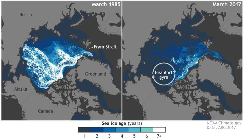
Figure 1: Maps showing the extensive loss of multi-year sea ice in the Arctic Ocean during the
past three decades (March 2017 vs March 1985). From: https://www.climate.gov/news-features.2
Figure 2: The development and implementation of the Last Ice Area Program, through step-wise
phases. ............................................................................................................................................. 3
Figure 3: Sketch representing the generalized role of sea ice in Arctic marine ecosystems. From
AMAP (2012). ................................................................................................................................ 4
Figure 4: A map made in support of world heritage designation within the Last Ice Area which
brings together all the current and proposed conservation management measures within the
region. ........................................................................................................................................... 15
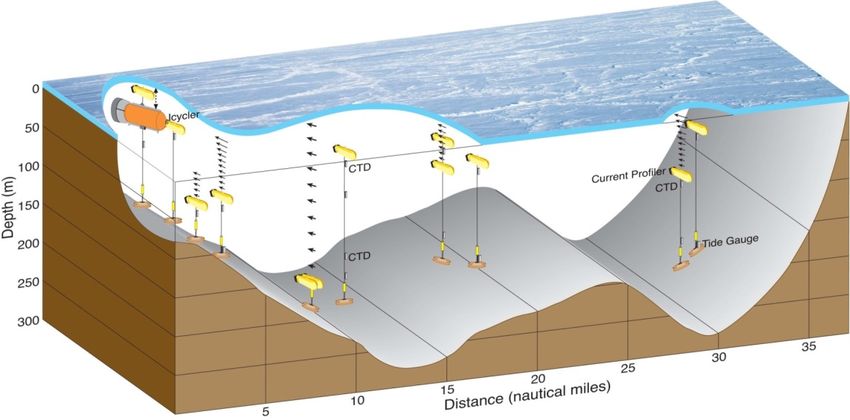
Figure 5: A graphic display of mooring instrumentation arrays for the Icycler, CTDs, and other
oceanographic instrumentation. .................................................................................................... 29
ivABSTRACT
Loewen, T. N., and Michel, C. 2018. Proceedings of the Multidisciplinary Arctic Program (MAP) – Last
Ice: Science Planning Workshop, January 16-17, 2018. Can. Manuscr. Rep. Fish. Aquat. Sci. 3159:
vii + 53 p.
The Fisheries and Oceans Canada (DFO) Last Ice Area (LIA) Science Program was established
after a Ministerial Announcement by the Government of Canada asserted Canada’s commitment
to the LIA in the fall of 2017. The four-year Multidisciplinary Arctic Program (MAP) – Last Ice
Science Program, aims to characterize the only region expected to retain summer sea ice over the
next decades. As permanent Arctic sea ice cover recedes, the LIA will be essential for sea ice
associated species, ecosystems and communities that depend on them. This region is one of the
most remote and inaccessible regions in the world and therefore generally lacks baseline
ecological knowledge. The Government of Canada has committed to work in collaboration with
northern partners and national and international stakeholders to better understand the LIA.
Extensive field sampling is planned for spring 2018 and subsequent years. The LIA Science
Planning Workshop, held in Ottawa from January 16-17, 2018 brought together national and
international partners, and stakeholders to share scientific knowledge of the LIA, identify key
science questions, and provide input to a Science Plan.
RÉSUMÉ
Loewen, T. N., and Michel, C. 2018. Proceedings of the Multidisciplinary Arctic Program (MAP) – Last
Ice: Science Planning Workshop, January 16-17, 2018. Can. Manuscr. Rep. Fish. Aquat. Sci. 3159:
vii + 53 p.
Le programme scientifique relatif à la zone de glace séculaire de Pêches et Océans
Canada (MPO) a été mis sur pied après que le gouvernement du Canada a fait une annonce
ministérielle affirmant l’engagement du Canada à l’égard de la zone de glace séculaire à
l’automne 2017. Le Programme multidisciplinaire de l’Arctique (MAP) – Glace séculaire, d’une
durée de quatre ans, vise à caractériser la seule région qui devrait conserver sa glace de mer en
été au cours des prochaines décennies. À mesure que la couverture de glace de mer permanente
dans l’Arctique recule, la zone de glace séculaire sera essentielle pour les espèces, les
communautés et les écosystèmes associés à la glace de mer qui en dépendent. Cette région est
l’une des plus isolées et des plus inaccessibles dans le monde et, par conséquent, elle souffre
généralement d’un manque de connaissances écologiques de base. Le gouvernement du Canada
s’est engagé à travailler de concert avec des partenaires du Nord et des parties intéressées à
l’échelle nationale et internationale pour mieux comprendre la zone de glace séculaire. Un
échantillonnage intensif sur le terrain est prévu pour le printemps 2018 et les années suivantes.
L’atelier de planification des sciences portant sur la zone de glace séculaire, qui a eu lieu à
Ottawa les 16 et 17 janvier 2018, a permis à des partenaires nationaux et internationaux et des
parties intéressées d’échanger leurs connaissances scientifiques sur la dernière zone de glace, de
cerner les questions scientifiques clés, et de contribuer à l’élaboration d’un plan scientifique.
vACKNOWLEDGEMENTS
The Last Ice Science Planning Workshop was planned and coordinated with the assistance of
Joclyn Paulic, Diane Jones, Kim Thomas, and Donald Cobb. Dr. Robert Young helped to co-
chair the meeting. The participants in the workshop (Appendix 2) provided presentations that
advanced and helped to achieve the purpose of the science planning meeting. These contributions
and discussions of LIA science were greatly appreciated during the workshop. The Last Ice Area
Science Planning Workshop was financially supported by Fisheries and Oceans Canada, LIA
Science Program. Thank you to (Jim Reist) and (Chantelle Sawatzky) for providing a review of
the Science Workshop Proceedings before publication.
viINTRODUCTION
The Science Planning Workshop can be considered the official kick-off of the LIA Science
Program. The 2-day workshop brought together 35 participants from 14 agencies in Canada and
abroad to discuss the science of the LIA.
Drs. Christine Michel and Robert Young co-chaired the Last Ice Area (LIA) Science Planning
Workshop. Dr. Michel gave the welcoming address and extended thanks to workshop
participants. She provided background on the early development of the LIA Science Program in
2010. Dr. Michel presented the workshop objectives, reviewed the agenda, and detailed the
break-out sessions. Specific objectives of the workshop were to: i) provide a forum to discuss
science in the LIA, ii) take stock of the current understanding and key science questions for the
LIA, iii) discuss linkages of the LIA science program with national and international Arctic
Science Initiatives, and iv) provide the basis for the development of the LIA Science Plan.
The breakout sessions aimed to: i) identify key science questions, knowledge gaps and
challenges, ii) link LIA science to Arctic policy and science initiatives, and iii) discuss program
coordination and communication.
Dr. R. Young highlighted the importance of unique Arctic habitats associated with the
disappearing remnant multi-year sea ice and the need of protection for future generations, as well
as the need to understand the ecology of the region and how it may change over the next 40-50
years. He welcomed participants to the science planning workshop. A round table of
introductions by participants followed (Appendix 2).
PRESENTATION SUMMARIES
MULTIDISCIPLINARY ARCTIC PROGRAM (MAP) – LAST ICE
C. Michel presented the introduction to the LIA Science Workshop, titled “Multidisciplinary
Arctic Program (MAP) – Last Ice”. The presentation provided background on the LIA Science
program both in terms of Arctic science and of how science-to-policy communication has
influenced Arctic priority initiatives, setting the stage for the LIA program. The acronym “MAP”
(Multidisciplinary Arctic Program) – Last Ice was introduced as a reminder that science in the
LIA is ground-breaking in a poorly studied region.
The overarching scientific context for LIA science is the rapidly changing sea ice in the Arctic
Ocean and in particular, the shift from multi-year ice to first-year ice (ice that remains over
multiple years versus ice that melts in summer). The comparison between the sea ice extent in
March 1985 (30 years ago) with the latest data in March 2017 was presented, showing
tremendous changes taking place in the Arctic Ocean as multi-year ice decreased from ca. half of
the sea ice extent in the 1980s to less than 20% according to latest records (Figure 1).
1Figure 1: Maps showing the extensive loss of multi-year sea ice in the Arctic Ocean during
the past three decades (March 2017 vs March 1985). From: https://www.climate.gov/news-
features.
The dramatic and rapid shift from multi-year towards younger sea ice affects physical, chemical
and biological processes at multiple scales and trophic levels. For ecological processes, changes
affecting the ice and snow habitat alter how marine mammals such as seals and polar bears use
the sea ice for denning. At the other end of the trophic spectrum, changes in sea ice can affect the
ice algal and microbial biodiversity living within. Changes in sea ice not only affect the ice but
also the ocean beneath it. Snow/sea ice change light transmission to the ocean and therefore the
ocean’s primary production. Changes in sea ice also have broader larger-scale impacts on the
climate and ocean circulation. For example through the albedo effect, as less reflective sea ice is
spatially present, warming the upper ocean, and a positive feedback loop reinforcing sea ice melt
is created. This also influences ocean circulation through the warming of surface water masses.
Models of sea ice extent in the Arctic project a summer ice-free Arctic by mid-century and
observations suggest that these projections are optimistic. The Last Ice Area is the only Arctic
region where summer sea ice is projected to persist over the coming decades. It is a unique and
important region within which to study sea ice associated processes and ecosystems.
The development and implementation of the LIA Science Program was described as a multi-
phased process (Figure 2). Phase 1 (2010-2013) started in 2010 with the Arctic Council Climate
Change Assessment SWIPA (Snow Water Ice, Permafrost in the Arctic); followed by the Arctic
Biodiversity Assessment. These two Arctic Council Assessment Reports recommended science
2to better understand sea ice processes and changes in the Arctic, including the ecological role of
sea ice, and its biodiversity and productivity. The reports recommended science and conservation
efforts in the Last Ice Area, recognized as the only region where multi-year sea ice remains in the
Arctic, and provided an impetus for program development.
In Phase 2 (2013-2016), science policy linkages and programs were further developed, with
Arctic Council reports highlighting the importance of safeguarding important marine areas and
biodiversity, as well as the importance of sea ice associated species and ecosystems in the Arctic.
A recent IUCN-WWF Report specifically identifies the remnant Arctic multi-year ice, the Last
Ice area, as a potential area of outstanding universal value due to its unique nature. The region
identified in the report is broader than DFO’s focal area for the MAP – Last Ice Science
Program, as our focus is on the multi-year ice region within Canada’s Exclusive Economic Zone
(EEZ) and accessible from established transportation bases such as Alert, Canada, at least in the
early stages of implementation of the science program.
The third phase (2017-2021) is the implementation stage of the DFO MAP – Last Ice Science
Program. Launched through a Ministerial Announcement by the Government of Canada in 2017,
DFO established the 4-year Last Ice Area Science Program.
DFO is adopting and developing a collaborative framework to combine expertise across regions
(4 DFO regions), using a whole-government approach (5 Departments), and with national and
international partners (5 partnering organizations). DFO Science in the LIA underpins Oceans
Management requirements for policy development (e.g., marine protected areas).
Figure 2: The development and implementation of the Last Ice Area Program, through
step-wise phases.
DFO recognizes the essential value of Northern partnerships. DFO engaged in initial dialogue
with the Government of Nunavut, Nunavut Wildlife Management Board (NWMB), the Inuit
Circumpolar Council (ICC), and Nunavut Tunngavik Inc. (NTI). The closest communities to the
Last Ice Area are Grise Fjord and Resolute Bay; communication with the Iviq Hunters and
Trappers’ Association and Resolute Bay Hunters and Trappers’ Association is on-going.
Suggestions for potential avenues for communication and engagement with northern partners
include providing input to annual planning meetings with NWMB, NTI and possibly FJMC
3(Fisheries Joint Management Committee), providing annual reports to the nearest communities
and co-management boards, and fostering engagement with the Government of Nunavut, and
taking part in science training and activities in programs such as N-CAMP (Nunavut Community
Aquatic Monitoring Program) and SMART Ice.
Partnering organizations in government, academia, and international partners were mentioned as
well as potential linkages in terms of science of the LIA.
The overarching scientific question for the LIA program was suggested as: “How does multi-
year sea ice in the LIA influence the structure and functioning of Arctic marine ecosystems; and
how is it changing?”
Figure 3: Sketch representing the generalized role of sea ice in Arctic marine ecosystems.
From AMAP (2012).
Scientific objectives for LIA are as follows:
1. Characterizing the LIA in terms of physical and biological processes in the context of
unique sea ice conditions (specifically old multi-year sea ice);
2. Documenting and improving knowledge of Arctic biodiversity and sea ice habitat and
habitat use;
3. Providing sea ice and ocean data to inform and better parameterise climate and
biogeochemical models.
4An integrated bio-physical system approach is proposed (Figure 3), combining aerial surveys for
habitat characterization and marine mammals, continuous observations of meteorological
conditions, ice conditions, and water conditions, using autonomous samplers and new technology
(e.g., unmanned aerial vehicle). Under-ice sampling, sea ice biochemical (e.g., nutrients,
biomass, and diversity) and physical measurements will accompany autonomous observations in
our multidisciplinary approach. Partners from the Alfred Wegener Institute (AWI) will use a
remotely operated vehicle to characterize under-ice conditions, to collect zooplankton, and to
collect fish larvae at the under-ice surface.
Dr. Michel presented a Gantt chart showing the LIA Science Program time table for 2017-2021,
indicating a second LIA workshop planned for January 2019. Dr. Michel concluded by
reinforcing the overall objective of this workshop, i.e., to discuss science of the LIA, and that the
discussions and presentations would help inform the LIA Science Plan. Workshop Proceedings
will follow.
A short discussion followed C. Michel’s presentation. The first question asked about the status
and interest of a working relationship between Greenland and Denmark in the LIA since the
science program is focused around Alert, NU. There is strong interest in working with
Greenland/Denmark due to proximity/influence of the Lincoln Sea. There were initial
discussions to this effect. A second question focused on the productivity of the LIA – how
productive is the LIA and is it considered a productive area? There are currently no production
estimates for the LIA; this is a science gap that needs to be addressed. The recent Lange et al.
(2017) paper suggests it is more productive than previously thought due to the potential role of
hummocked ice. A further comment was made that productivity of the region may increase in the
future due to changes in the multi-year sea ice conditions. A third question addressed scoping for
the LIA science field research – why was the current field season location scoped for LIA? The
rationale for scoping had to do with boundaries of the LIA – the exact boundaries for LIA are not
established. The LIA for the Science Program focusses on the region where old multi-year sea
ice remains (i.e., the main driver of LIA) and importantly, the logistics capability to carry out the
science. The wider LIA (northern boundary of the Canadian Arctic Archipelago) is extremely
poorly characterised so there is a need to establish a start point. The area chosen also has some
earlier sea ice data that can be used to complement the new data collection. Further, based on the
Treasury Board submission, this is the area targeted by the program. Accessibility to the multi-
year ice region north of the Canadian Arctic Archipelago is very limited; it is possible that
declining sea ice will make it easier to access some of the areas in the future.
ARCTIC SCIENCE AT FISHERIES AND OCEANS CANADA
B. Keatley provided a presentation titled “Arctic Science at Fisheries and Oceans Canada”.
The presentation focused on DFO’s national program and provided a broad overview. The Arctic
science component is a key part of decision making and strategic outcomes. Arctic science
supports DFO strategic outcomes in three areas: 1. economically prosperous maritime sectors
5and fisheries, 2. sustainable aquatic ecosystems, and 3. safe and secure waters. This is done
through supporting ongoing operations, contributing to national and international issues, and
collaborating with co-management and other partnerships. The scope of departmental Arctic
science includes freshwater, coastal, and marine ecosystems. It additionally includes physical,
chemical, and biological processes. Finally, the scope ties together the linkages between
biogeochemical and physical processes through food webs. Examples of DFO Arctic science
activities include: stock assessment, research and monitoring of structure/function of aquatic
ecosystems, impacts of aquatic ecosystem stressors and change, science advice, hydrographic
charting and mapping products, co-management and research with northern partners, and
participation in international scientific initiatives. Some recent national drivers within the
department are: 1. ministerial mandate commitments (i.e., implications of climate change in
Arctic marine ecosystems, marine conservation targets, and restored funding to DFO science
programs), 2. State of the Ocean ecosystem reporting, 3. northern Marine Transportation
Corridors, 4. Ocean Protection Plan, and 5. co-development of a new Arctic Policy Framework
(with Indigenous, territorial, and provincial partners). Recent international drivers relevant to the
department include: 1. US-Canada Joint Statements, 2. White House Arctic Science Ministerial,
3. Central Arctic Ocean fisheries agreement, and 4. the Arctic Council. The USA-Joint
Statements (March, December 2016) sought to help ensure a strong, sustainable and viable
Arctic economy and ecosystem. This included low impact shipping corridors with a focus on
sensitive ecological areas as well as exploring the protection of the Last Ice Area. With the
White House Arctic Science Ministerial (September 2016), joint statements on international
collaboration and inclusion of Indigenous peoples in science and decision-making were made.
There was also an agreement to have a 2nd Arctic Science Ministerial in October 2018. The
Central Arctic Oceans fisheries agreement was successfully negotiated in late 2017 and was
supported by science input. Finally, the Arctic Council, through the Protection of the Arctic
Marine Environment (PAME) working group, the International Council for the Exploration of
the Sea (ICES), and the North Pacific Marine Science Organisation (PICES) working group
helped with the assessment of the Central Arctic Ocean. The Conservation of Arctic Flora and
Fauna (CAFF) working group of the Arctic Council provided updates to the Circumpolar
Biodiversity Monitoring Program (CBMP) Arctic Marine Biodiversity Report. From a national
DFO perspective, there is a large number of Arctic initiatives that are quickly moving forward
leading to an exciting time for Arctic science.
A short discussion followed B. Keatley’s presentation regarding the political context and
potential impacts on Canada’s commitments.
FROM PROCESS STUDIES TO SYSTEM UNDERSTANDING: ALFRED WEGENER
INSTITUTE’S (AWI) INTERDISCIPLINARY RESEARCH IN THE ARCTIC OCEAN
C. Haas provided a presentation titled “From Process Studies to System Understanding: Alfred
Wegener Institute’s (AWI) Interdisciplinary Research in the Arctic Ocean”. Science studies
6done at AWI were presented and focussed on interdisciplinary research from process studies to
system understanding. Dr. Haas has worked in the LIA for approximately 10 years. Germany’s
interest in polar research is to better understand global views of climate and social responsibility.
Germany has logistical and infrastructure developed to support Arctic programs.
AWI’s mission statement is to be an international leader in polar research. AWI makes
significant contributions by promoting awareness of how our global environment and Earth
system are changing in the context of climate and coastal research. AWI provides the science
basis for political decisions and provides essential polar and marine infrastructures. Science
(geological, biological, and climate science) interest encompasses the past, present, and future as
well as ocean floor to the atmosphere. Research infrastructure includes 3 stations within the
Antarctic and 2 stations in the Arctic. Each pole has an established and operating year-round
station. In addition, 6 ocean going vessels support polar science programs.
AWI has cooperative partnerships that are international and extensive. Canada is one partnership
which has resulted in more than 200 joint publications. On an international level, AWI has
provided support and aid to the development of the Weddell Sea Marine Protected Area. This is
an example of science knowledge dedicated to research and the importance of protection. The
AWI research program relating to Polar regions and Coasts in a Changing Earth Systems
(PACES II 2014-2018) focuses on 4 main topics: 1.) changes in the Arctic and Antarctic, 2.)
fragile coasts and shelf seas, 3.) earth system from a polar perspective (data acquisition,
modelling and synthesis), and 4.) interactions between science and stakeholders. Specific focus
on topic 1 demonstrates where LIA falls within the research program. An aspect of this theme is
the examination of Arctic sea ice and its interaction with ocean ecosystems. The main driver is
global change. This is manifested in a multitude of environmental changes with unknown
consequences for humans, ecosystems, biodiversity and biogeochemical fluxes. For example,
Arctic sea ice extent in the month of September has decreased from 1980-89 to 2008-17. The
climate interacts with polar seas, marine ecosystems, and biogeochemical processes. The science
goals are to unravel the causes of sea ice variability, ice-shelf loss and its impact to ecology and
biodiversity and to quantify and model the physical, chemical, and ecological changes in
association to their climate feedbacks. Field observations, process studies and laboratory
experiments with particular focus on long-term observations from sea ice to the ocean floor are
methods to achieve outlined goals. An example study is the export of algal biomass from melting
Arctic sea ice that examines the consequences of primary production and export (Boetius et al.
2013). Future research developments include Frontiers in Arctic Marine Monitoring (FRAM:
2014-2021) and the Multidisciplinary drifting Observatory for the Study of Arctic Climate
(MOSAiC: 2019-2020). FRAM is designed to help build strategies for long-term, year-round
synchronous observations and biogeochemical modelling. MOSAiC research will focus on the
biophysical processes of the sea ice ocean ecosystem during the Arctic winter period. MOSAiC
is a major international research initiative under the International Arctic Science Committee
(IASC) to improve the representation of Arctic processes in climate and ecosystem models.
7A short discussion followed C. Haas’s presentation. A question was asked about the governing
body that protects the Weddell Sea Marine Protected Area. Antarctic treaties are the governing
body for protecting the Weddell Sea Marine Protected Area. A second question was asked
regarding how to link into other programs like MOSAiC. Presently, there are no agreed linkages
but there may be something in development for the Beaufort Sea in the near future in association
with the Amundsen. Gathering of key observations made at all key sites is occurring which is
further allowing for identification of complements and linkages of studies. A further comment
was made asking if formal research arrangements would benefit this program instead of informal
arrangements. There are political aspects to create formal international agreements. If
formalizing agreements increases funding opportunities, it would be worthwhile to pursue. There
are still opportunities to join MOSAiC if funding is available although it is expensive to join.
ARCTIC MARINE PROTECTION
C. Wenghofer provided a presentation titled “Arctic Marine Protection”. The presentation
provided a background to the Oceans program, DFO’s approach to Arctic Marine Protection, the
interest in the LIA, the linkages of science/traditional knowledge to co-management, and the
next steps forward. At the federal level, Canada has recently committed to international marine
conservation targets (MCT) to conserve 10% of coastal and marine areas by 2020 (with specific
targets to protect 5% of Canada’s marine and coastal areas by 2017 and 10% by 2020). In 2016,
the Joint Statement on Climate, Energy, and Arctic Leadership was made between the Canadian
Prime Minister and the USA President that reaffirmed their commitment to protect 10% of
marine and coastal areas by 2020. This helped to launch a new process with Northern and
Indigenous partners to explore options to protect the “Last Ice Area” within Canadian waters, in
a way that benefits communities and ecosystems.
The Oceans Act Marine Protected Areas (MPAs) are established to conserve and protect
commercial and non-commercial fishery resources, endangered or threatened species, unique
habitats, and high biodiversity/biological productivity. Two Oceans Act MPAs have been
designated to date within the Western Canadian Arctic (Tarium Niryutait (TNMPA) in 2010 and
Anguniaqvia niqiqyuam (ANMPA) in 2016). DFO is pursing work to establish new MPAs in the
Eastern Canadian Arctic. Presently, a number of areas have been identified by an Area of Interest
(AOI) working group (DFO, Regional Inuit Associations, and NTI) and DFO is awaiting
recommendations from Regional Inuit Associations.
The LIA is being considered as a World Heritage Site. The World Wildlife Fund’s (WWF)
application to have the LIA put on the Canadian Tentative list was not moved forward, however,
Park’s Canada’s application was accepted for Simirlik and Lancaster Sound. The LIA is a large
region within the high Arctic of Canada and Greenland. It is a region where the oldest Arctic
multi-year sea ice is found and is considered a refuge for Arctic species based upon expected
presence and persistence of summer sea ice. The LIA includes some of the most biologically
productive areas in the Arctic Ocean. It is projected to retain multi-year sea ice into the future
8thus providing important habitat for ice-dependent and culturally significant species. For
assessment purposes, DFO (Oceans Program) is looking at a broad area to work with
communities and have direct involvement in the process.
WWF Canada, Arctic Net and other organizations have been collecting science and traditional
knowledge about the LIA for years and have led calls for its protection. A number of resources
are available to examine the LIA including reports on the Ecologically and Biologically
Significant Areas (EBSAs) by DFO, the Nunavut Coastal Resource Inventory by the
Government of Nunavut, the draft of the Nunavut Land Use Plan, and the Inuit
Qaujimajatuqangit (IQ)/traditional knowledge studies. Results from this workshop and resulting
science plan will inform management decisions in the future.
The Government of Canada has committed to renewing its relationship with Indigenous Peoples
on a nation-to-nation basis, based on recognition of rights, respect, co-operation, and partnership.
Indigenous rights and land claim obligations are respected when advancing MPAs and
partnerships with Indigenous groups are integral to meeting our common marine conservation
goals. Indigenous groups will be essential in science and monitoring programs as well as in IQ
collection. The Nunavut Agreement is respected by the Canadian Federal Government. Much of
the LIA includes areas outside of the land claim, areas in the Canadian Exclusive Economic
Zone (EEZ), portions of the Inuvialuit Settlement Region, and the Nunavut Settlement Area
(NSA). The approach will be to focus solely on the NSA extending out to the EEZ boundary.
There is a requirement to enter into the Inuit Impact and Benefit Agreements (IIBA) for any
areas considered within the Nunavut Settlement Area. A “Whole of Government Approach” is
being developed.
There are a number of other initiatives in the region that should be considered. The Government
of Canada is committed to creating an Arctic Policy Framework to identify shared interests and
priorities.
In partnership with Qikiqtani Inuit Association (QIA), the Government of Nunavut, the
Government of Canada announced (14 August 2017) the final boundaries and the interim
protection of the Tallurutiup Imanga (Lancaster Sound) as a National Marine Conservation Area
(NMCA). The Pikialaorsuaq Commission (23 November 2017) issued its report on the current
state of the North Water Polynya. The report has been acknowledged and will be discussed with
Inuit leaders.
We do not know how each area will look into the future and this needs to be considered in any
design. There is a need for more modelling and flexibility in the consideration of design. As
well, opportunities exist for considering locally driven management options and areas being
considered for protection under land use planning processes. This unique opportunity lends itself
to broader integrated management approaches for the entire area. The area is expansive and the
opportunity to utilise a variety of tools and/or approaches is available (e.g., Oceans Act MPAs,
9NMCAs, Integrated Oceans Management, industry guidance, Community Management Plans,
etc.). Lack of capacity is an issue for partnering groups.
The federal government is making an investment in taking the next steps forward in conservation
targets. The Government of Canada will work with Inuit and Northern partners to support and
protect the future of this area in Canada’s High Arctic Ocean. Dialogues with QIA, NTI, ICC,
and the Government of Nunavut will occur. There will be continued information gathering from
existing sources that considers both ecological and cultural values. There is engagement with
broader external partners (NGOs, academia, etc.). And consultations are being done with nearby
communities to determine support.
A short discussion followed C. Wenghofer’s presentation. A question was asked regarding the
meaning of an MPA and Oceans Act MPA and the variation of activities that can occur in
individual MPAs (i.e., can you take a tanker through an MPA?). Activities that are allowed or
prohibited are based on the objective(s) of the MPA and the impact(s) of those activities. Other
measures such as fisheries closures that meet specific criteria also help to reach the 2020 targets
whereas Oceans Act MPAs are referring to legislated MPA regions. The ability to undertake a
specific activity is dependent upon the protection targets for the specific region. There is
discussion on minimum standards but this has not yet been established. In a warming climate,
how will we incorporate this into the MPA objective development? This is a question that is
open beyond climate change and can be based on conserving the environment from other
activities to protect new ocean areas. Any area we protect will be subject to change with
environment and ecology being fluid. The contradiction is very apparent. There is a lot of need
for discussion and interaction with Arctic communities for the development of MPAs and this is
seen as a good approach. This usually means that there is a tendency to develop coastal MPA’s
due to community interaction. This then led to a question about how to develop more marine
offshore MPAs. Offshore MPA development is happening. Partners have been supportive of
offshore marine refuges. It is acknowledged as a challenge and part of the discussion for the
protection of the LIA.
A general discussion followed. The first topic related to the terminology around conservation and
MPAs. There is another term used called other effective area-based conservation areas. MPAs
refer to Oceans Act legislation and marine refuges are considered other area based conservation
areas. A second topic was discussed regarding the Government of Canada’s consideration for the
biodiversity convention for management planning (in reference to the biodiversity convention
beyond national consideration). The United Nations discussions are occurring to develop new
instruments for conservation beyond jurisdiction. This would occur through new treaties. There
is no overarching mechanism right now but this doesn’t mean it cannot occur (e.g., Antarctic
Weddell Sea MPA). Within Canada we are only looking to develop conservation areas (i.e.,
MPAs, etc.) within our own jurisdiction. We can do this with other partners and have on
international issues such as the central Arctic Ocean (high seas management). This is usually
resource based versus conservation based. A third topic was discussed on the flexibility of the
10LIA scope for DFO (Science Program) and its difference from WWF’s scope. The scope of
science for the LIA is smaller than some definitions of the LIA (more than 1 provided in the
meeting). DFO (Science Program) is operating under the constraints of funding and hope to do a
very effective job within the region where they are working. There is a willingness to discuss the
number of different programs that can be integrated through collaboration as the LIA program
moves forward. The objective for the department is to provide the best advice and ecosystem
science for the region at large as further discussion occurs on conservation targets and protection.
A follow-on topic relating to LIA boundaries was discussed relating to the differences and areas
not considered for the science program. If other areas were considered there may be more
synergies with N-CAMP and other similar programs to engage northern community members.
The boundaries for the LIA provided on the map are variable. The science work being completed
is bound by funding constraints and accessibility. As well there is a focus in this initial stage on
where multi-year sea ice will remain and the only way to access this area is by land. N-CAMP is
linked to communities whereas this research program is not. There is a desire to incorporate
Northern individuals into programs whenever possible and the LIA science program team hopes
to do this through stewardship and mentorship. There are strong links between the remote
Northern Archipelago and downstream regions near communities. A participant pointed out that
the LIA is understudied but not un-studied so information does exist on the region from
programs such as Joint Ocean Ice Studies (JOIS) and Arctic Net where ships were used to collect
data around the marginal regions of the LIA. Another participant asked about the purpose of the
meeting (to decide what will happen based on the area chosen already or can there be discussion
and openness to consider other logistical areas). There are no other options for other Canadian
bases at the present time. Everyone is here to help the development of the LIA science program
around the region already highlighted and discussed. A follow on question related to the use of
Alert and why this area was selected for the LIA science program. Plenty of areas that have
multi-year sea ice are logistically easier to access and cheaper than the area selected. The one
important difference is the division between the types of multi-year sea ice: 1.) where it is
formed, and 2.) where it is wasted (melts). Multi-year sea ice is formed to the north of Alert and
more southern locations in the Arctic are where multi-year sea ice is wasted (or melts). There is a
need to distinguish these two types of regions and this is the reason why work is being done near
Alert. To follow on, a participant commented that there is a large emphasis on ecology and thus
it may be less important to be near forming multi-year sea ice versus near wasting areas. There is
a large difference between ecological production in the multi-year sea ice formation regions and
wasting regions (i.e., the microbiological communities are significantly different and there are
differing dynamics at play). As well, looking to the future, there is a need to examine seasonality.
It is then better to work in an area where multi-year sea ice is persisting for a longer period of
time. Is there an interest in the mechanics of sea ice (i.e., different types of formation)? Yes, this
is what links the LIA to the Arctic Ocean on a broader scale.
11PARK’S CANADA ARCTIC CONSERVATION INITIATIVES
F. Mercier provided a presentation titled “Park’s Canada Arctic Conservation Initiatives”.
Parks Canada Agency (PC) is responsible for protecting representative examples of Canada’s
natural and cultural heritage. There are 46 national parks and one national urban park under PC’s
mandate. Additionally there are five national marine conservation areas (NMCAs), 981 national
historic sites, and nine historic canals under PC’s mandate.
NMCAs have been developed by PC. Their purpose is to protect and conserve areas
representative of Canada’s 29 marine regions. They encourage the understanding, appreciation,
and enjoyment of marine heritage. They are established and managed under the Canada National
Marine Conservation Areas Act. The objective of NMCAs are to represent the diversity of
marine ecosystems, maintain ecological processes and life support systems, preserve
biodiversity, protect endangered species and critical habitats, protect cultural resources,
encourage ecological research and monitoring, use traditional knowledge and science to inform
management and planning, and provide interpretation of marine areas for the purposes of
conservation, education and tourism. NMCAs are considered multiple use protected areas
managed for ecological sustainability. They must be zoned, including zones of high protection.
There is a prohibition of activities such as hydrocarbon and mineral exploration and development
as well as disposal at sea. Renewable use activities consistent with objects are permitted (i.e.,
fishing, shipping). Management of NMCAs occurs in cooperation with other federal departments
(DFO and Transport Canada) and is supported by local management committees. Currently,
there are eight national parks with marine components (~8,950 km2), one NMCA (Tallurutiup
Imanga: 109,000 km2) and funding to assess three new NMCAs. The Tallurutiup Imanga Inuit
Impact Benefit Agreement has been discussed and negotiations will start next month and will
involve other government departments. One of the NMCAs being considered is in the LIA and is
offshore of Quttinirpaaq National Park.
There is limited science capacity for large projects. Site ecologists are assigned to each national
park/NMCA. Their focus is on monitoring ecosystem health to inform adaptive management.
They work with local community members to better understand each site and inform
management. There are several needs associated with NMCAs including more complete
species/habitat inventories for sites, research on food webs, oceanography, etc. to better
understand how the ecosystem works, how to best approach interpretation and visitor experience,
and simplify effective means of monitoring.
There are potential opportunities for collaboration. PC has a presence at each of its sites and has
the possibility of in-kind support. PC has purchased RV David Thompson to support PC’s
marine science and underwater archaeological work. It will be used to conduct research on the
wrecks of HMS Erebus, HMS Terror (Queen Maud Gulf near King William Sound) and HMS
Investigator (Mercy Bay, north of Banks Island), and for marine biology and survey projects in
Lancaster Sound.
12A short discussion followed F. Mercier’s presentation. A question was asked regarding selected
NMCA proposed sites and whether they would be counted towards 2020 conservation goals
(10% marine protection). There is a desire to count these areas towards the 2020 conservation
goals but this will be dependent on the QIA. The capacity of our northern partners is stretched
presently. A following question asked about the potential expansion plans for shelter areas on
Ward Hunt Island. There is shared interest to use this shelter. Plans are not presently known
about expanding the shelters but will be looked into and participants can be connected with
individuals taking care of this for PC after the science workshop. Another question was asked
regarding collaboration between PC and DFO on marine conservation areas. There is
collaboration and these NMCAs will be considered to be part of MPA network planning that is
led by DFO. PC is establishing NMCAs to represent bioregions close to the proximity of other
existing land-based parks. A further comment inquired about the advantage of joint conservation
areas. PC can add DFO’s interest into protection plans for an NMCA. Parks works with
communities to deal with management. There is no advantage right now to double up as agencies
from the perspective of the communities or organisations. A final question was asked regarding
the implications for world heritage listing for NMCA (referencing LIA). PC is the lead for world
heritage site and designation (in Canada). To be listed, the area has to be under some protection
legislation and have a management plan. A follow on question concerned the rationale of
choosing the proposed LIA above Quttinirpaaq National Park. It is the best representation of the
region and proximity to another land-based park. Objectives of the NMCA can be achieved here
most easily in comparison to other proposed regions for LIA.
LIA: FROM WWF PROJECT TO CANADIAN ACCOMPLISHMENT
C. Tesar provided a presentation titled “LIA: From WWF Project to Canadian
Accomplishment”. C. Tesar was the international lead of the LIA project for WWF’s Arctic
programme for the past 8 years and is now a consultant that works on WWF Canada’s LIA. M.
Giangioppi is a colleague with WWF Canada leading work on Arctic Marine Conservation. The
LIA developed in 2008 out of a meeting in Washington held by WWF to discuss the future of
polar bear conservation, collect of science and knowledge, predict future issues and threats, and
discuss how to address challenges. The common decision was that the biggest threat to polar bear
conservation was not hunting or development but habitat loss as a result of climate change.
The WWF boundaries for the LIA are based on a summer minimum ice projection for 2040
based on the RCP4.5 scenario within the national jurisdictions of Canada and Greenland. The
margins for LIA are purposefully blurred since it is a projection and the extent and location of
the ice edge in 2040 is imprecise science. Areas outside the boundary could be just as important
ecologically, economically, and culturally as areas inside the line. The rationale was based on the
ice-modelling work commissioned by WWF from Bruno Tremblay and team at McGill
University. WWF Canada then developed a more optimistic scenario and prepared a projection
13based on RCP4.5. This scenario is one that most closely follows the implementation of the Paris
Agreement.
The WWF’s vision for the LIA is a mosaic of management that would lead to integrated
management of the area (i.e., various management tools). The vision is to have some areas
within the LIA potentially managed entirely by Inuit (i.e., Pikialasorsuaq) while others could be
comprised of co-management between Inuit and the Canadian Government (already observed in
some areas). Figure 4 shows a variety of existing and proposed conservation management
measures.
Official consultation with Inuit groups started in 2012 in Nuuk, Greenland. Representatives from
the QIA, NTI, NWMB, and the Government of Nunavut were present at the meetings along with
Greenlandic Government representatives. The workshop was co-hosted by the ICC. The
meetings were intended to introduce the project, and to receive guidance on how we should
proceed in reference to the research agenda. The meeting outcomes identified gaps such as the
need to do more ice modelling, to better understand the polynya, and to better define the likely
outcomes for ice-associated life with decreased sea ice. Two more workshops also co-hosted by
the ICC have since followed. These meetings, held in Iqaluit, had a broad scope in both audience
representation and discussion topics.
14Figure 4: A map made in support of world heritage designation within the Last Ice Area
which brings together all the current and proposed conservation management measures
within the region.
WWF’s international reach has allowed for broader public support for the project. This helps to
start discussions at a policy level, and move to higher level engagement with Inuit and with
governments. International efforts include taking a sailboat through the LIA with both science
and media on board. International WWF efforts also included presentations to the International
Marine Protected Areas Congress, the World Parks Congress, and the Arctic Council.
WWF’s national vision is the construction of an MPA network for the Eastern Canadian Arctic.
The scope of the project overlaps with the LIA. The purpose of the project is to help identify
candidate areas for marine protection including an analysis to help map out and inform
management decisions. WWF held the first expert workshop (February 5-6, 2018, Ottawa,
Canada) to discuss conservation features and methodology to identify candidate areas.
WWF, in support of their international vision, has helped support the ICC’s Pikialasorsuaq
Commission. This polynya is a particular location of importance for Inuit. One way to support
this project was the commissioning of an interactive atlas that brings together ecological and
cultural information in one place from a team at Dalhousie University. WWF is continuing to
support and engage with the work of the ICC.
15WWF has commissioned research to help address questions from Inuit. Better modelling of sea
ice was identified as a research gap and this was done at the outset of the LIA project. Another
research study commissioned by WWF examined polynya persistence in the region to understand
detectable patterns in how polynya physical characteristics might react in response to changing
climate. Further studies examined how ice-dependent and ice associated life might use ice in the
future. Model projections of animal populations need to start with baseline assessments in the
present day. WWF has contributed to several assessments of ice-dependent animals including
polar bear populations, and to modelling work that examined sea ice projections and attempted to
determine ice persistence for polar bear habitats. In brief, it is predicted that the LIA will be the
best polar bear habitat in the future (2050). Other activities to ensure the support of management
measures, include IQ knowledge collection, Inuit involvement in the field programs relating to
narwhal surveys (Tremblay Sound) and hosting workshops on seals. WWF has commissioned
from ICC a compendium of existing published Traditional Ecological Knowledge (TEK) about
the LIA and has also published a compendium of published science on natural resources in the
LIA. A study on economic opportunities was commissioned to independently study the non-
renewable resources of the LIA.
WWF does not view the LIA as a WWF project. Government of Canada commitments for the
LIA are welcomed. As well, Inuit themselves are leading the Pikialasorsuaq Commission.
International and national levels of WWF are still committed to supporting this project by
generating as much knowledge as possible.
WWF also partnered with National Geographic’s Pristine Seas Program for a presentation to the
Arctic Council working groups. A full length feature on the LIA is available as a printed article
and featured in National Geographic. A movie is in production. The WWF has an ongoing role
for policy in the Arctic Council as an observer to the council and participant in the Council’s
MPA projects.
A short discussion followed C. Tesar’s presentation. The best polar bear habitat is the margins of
the LIA. Would they move further north if multi-year ice shrinks? The margins of the LIA are
the most productive. They will change over long periods of time. Southern polar bear stocks are
in more trouble. The open-water season is key to determining the health of polar bear
populations. Polar bear populations further north are likely doing well. A secondary question was
asked regarding an upcoming workshop. Can more information be provided? The workshop will
focus on the five marine priority areas for network planning. The Government of Canada is
focused on network planning in the Western Arctic and so WWF is focused on filling the gap in
the Eastern Arctic. The process to identify candidate MPAs has begun to develop a network. The
first workshop will be held from 1st February to 7th February, 2018 and will be followed up by a
panarctic network workshop. There will be two more workshops before the end of 2018. The
first workshop is to discuss conservation features as part of the network and discuss conservation
objectives. This will help to identify gaps. A third question/topic followed regarding the LIA
map boundaries. The predicted summer sea ice extent in 2040 (RCP4.5) is being used as a guide
16Vous pouvez aussi lire