BEECHWOO D DESIGN COMMUNITY - Documents
←
→
Transcription du contenu de la page
Si votre navigateur ne rend pas la page correctement, lisez s'il vous plaît le contenu de la page ci-dessous
PLAN DE CONCEPTION COMMUNAUTAIRE DE

BEECHWOOD
COMMUNITY DESIGN PLAN
           Publication : 3-16
OTTAWA CITY COUNCIL
                           27 SEPTEMBER 2006
                        ANDREW S. HAYDON HALL
                                 1:00 p.m.

                               DISPOSITION 65

9.        BEECHWOOD COMMUNITY DESIGN PLAN,
          OFFICIAL PLAN AMENDMENT AND ZONING BY-LAW
          AMENDMENTS

COMMITTEE RECOMMENDATIONS AS AMENDED

That Council:

1)   Approve the Beechwood Community Design Plan, as detailed in Document 2,           4)   Approve the amendments to the former City of Vanier Zoning By-law, as
     “except that the following clause shall be added at the end of Section 1:              detailed in Document 5, except that the proposed building height increases at
                                                                                            222 and 260 Beechwood Avenue be removed until such time as the view
     ”This Plan should be amended if the view protection study for Beechwood                protection study for Beechwood Cemetery ascertains that the building heights
     Cemetery indicates that the properties in the Planning Area will not be able to        can be achieved without affecting the view to be protected.”;
     achieve the levels of intensification as contained in the Plan.”;
                                                                                       5)   Approve the amendments to the former Village of Rockcliffe Park Zoning By-
2)   Approve an Official Plan Amendment to the Rockcliffe Park Secondary Plan of            law, as detailed in Document 5, “…except that the proposed building height
     the City Council Approved Official Plan, as detailed in Document 4 except that         increases at 2 Acacia Avenue and 207, 229 and 231 Beechwood Avenue be
     490 Oakhill Road be excluded / deleted from the Official Plan Amendment.               removed until such time as the view protection study for Beechwood Cemetery
                                                                                            ascertains that the building heights can be achieved without affecting the view
3)   Approve the amendments to the former City of Ottawa Zoning By-law, as                  to be protected.”, and;
     detailed in Document 5, except that:
                                                                                       6)   In relation to 3, 4 and 5 above, that there be no further notice in accordance
     a)   The proposed building height increase at 11 Champlain Street be removed           with Section 34(17) of the Planning Act;
          until such time as the view protection study for Beechwood Cemetery
          ascertains that the building height can be achieved without affecting the    7)   Direct staff to prepare an Official Plan Amendment and Zoning By-law
          view to be protected, and                                                         Amendments that would result in the protection of the view of Parliament Hill
     b)   The reference "to permit a restaurant/à permettre un restaurant" in the           from Poet's Hill and the Tommy Douglas Memorial at Beechwood Cemetery.
          legend of Map 1 of Document 5 be removed.
                                                                                       CARRIED as amended by the following Motions:
MOTION                                                                                  MOTION

Moved by Councillor J. Legendre                                                         Moved by Councillor G. Bédard
Seconded by Councillor G. Bédard                                                        Seconded by Councillor J. Legendre

WHEREAS the Planning and Environment Committee at its meeting on September              That Section 2.5.5 - Planning Strategy - Beechwood Community Design Plan, be
12, 2006 carried a staff report (ACS2006-PGM-POL-0037) that proposed a Special          amended to read – “Design Compatibility on Barrette Street and Charlevoix Street.”
Waterfront Area for the City-owned waterfront lands beside the St. Patrick Street
Bridge in the Beechwood Community Design Plan;                                          CARRIED

AND WHEREAS the List of Zoning Changes contained in the staff report proposed
zoning changes to implement the Special Waterfront Area by creating an Exception
to the EW-Waterway Corridor Zone for these lands;

AND WHEREAS the List of Zoning Changes proposed to permit a community
centre on these lands and reduces the building setback from Beechwood Avenue to
3.0 m and exempts parking and loading provisions for the first 85 m2 of gross floor
area for a community centre;

AND WHEREAS it is premature to determine the nature of the Special Waterfront
Area in the Beechwood Community Design Plan and the type of zoning changes that
would be required to implement the Special Waterfront Area:

BE IT THEREFORE RESOLVED that:

a)   The Beechwood Community Design Plan contained in Document 2 of Item 9 of
     Planning Committee Report 54A be amended by replacing the first paragraph
     introducing the performance criteria of Sub-section 2.3.7 Special Waterway
     Area with the following:

     “The Special Waterfront Area is intended to be a focal point for public
     recreational and waterfront viewing activities in a mainstreet setting. The City
     will assess creative submissions to use these lands in close consultation with
     the local community and based on the following performance criteria:”

b)   The List of Zoning By-law Changes contained in Document 5 of Item 9 be
     amended by removing all of the proposed revisions relating to the EW-
     Waterway Corridor Zone along the Rideau River, beside St. Patrick Street
     Bridge

c)   There be no further notice in accordance with Section 34(17) of the Planning
     Act.

CARRIED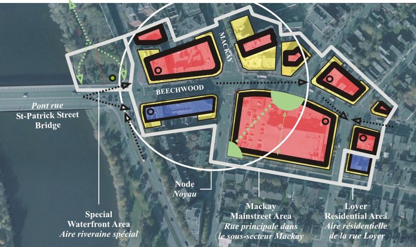
PLAN DE CONCEPTION                                   BEECHWOOD
COMMUNAUTAIRE DE BEECHWOOD                           COMMUNITY DESIGN PLAN

     TABLE DES MATIÈRES                       PAGE         TABLE OF CONTENTS

1.0.0 L’AVENUE BEECHWOOD AUJOURD’HUI           1     1.0.0 BEECHWOOD TODAY

1.1.0 ANALYSE COMMUNAUTAIRE                    3     1.1.0 COMMUNITY ANALYSIS

1.2.0 ANALYSE DE LA CONCEPTION URBAINE         9     1.2.0 URBAN DESIGN ANALYSIS

1.3.0 ANALYSE DU PAYSAGER DE LA RUE ET DES     15    1.3.0 STREETSCAPE AND CORRIDOR ANALYSIS
      COULOIRS DE CIRCULATION

2.0.0 LA STRATÉGIE D’AMÉNAGEMENT               21    2.0.0 PLANNING STRATEGY

2.1.0 OBJECTIFS EN MANNIÈRE D’AMÉNAGEMENT      21    2.1.0 PLANNING OBJECTIVES

2.2.0 STRATÉGIES D’AMÉNAGEMENT                 22    2.2.0 DEVELOPMENT STRATEGY

2.3.0 ZONAGE                                   29    2.3.0 ZONING

2.4.0 ENVELOPPE DU BÂTIMENT                    33    2.4.0 BUILDING ENVELOPE

2.5.0 CRITÈRES DE CONCEPTION URBAINE           36    2.5.0 URBAN DESIGN CONSIDERATIONS

3.0.0 L’AVENUE BEECHWOOD DEMAIN                41    3.0.0 BEECHWOOD TOMORROW

3.1.0 LE MODÈLE TRIDIMENSIONNEL                41    3.1.0 THE 3-D MODEL

3.2.0 PANORAMAS IMPORTANTS                     42    3.2.0 IMPORTANT VISTA’S

3.3.0 IMAGES ILLUSTRANT DES ENDROITS PRÉCIS    43    3.3.0 SPECIFIC ILLUSTRATIONS
PLAN DE CONCEPTION                                                                   BEECHWOOD
  COMMUNAUTAIRE DE BEECHWOOD                                                           COMMUNITY DESIGN PLAN

   L’AVENUE BEECHWOOD AUJOURD’HUI                                               1.     BEECHWOOD TODAY

Le présent Plan de conception communautaire (PCC) vise à                             The purpose of this Community Design Plan is to guide future
orienter les changements qui seront apportés dans le secteur                         changes over the next twenty years for the Beechwood Avenue           1    BEECHWOOD TODAY
                                                                                                                                                                L’AVENUE BEECHWOOD
Beechwood au cours des vingt prochaines années, lesquels                             area involving the following:                                              AUJOURD’HUI
toucheront :
                                                                                         Zoning and urban design considerations                            2    PLANNING FRAMEWORK
  •   le zonage et les critères de conception urbaine                                    Land development proposals                                             LA STRATÉGIE
  •   les propositions d'aménagement foncier                                             Streetscape and road improvements                                      D’AMÉNAGEMENT
  •   le paysage de rue et les travaux d’amélioration des routes;                        Civic initiatives
  •   les initiatives municipales                                                                                                                          3    BEECHWOOD TOMORROW
                                                                                                                                                                L’AVENUE BEECHWOOD
                                                                                     This Plan is based on the following directions taken from the              DEMAIN
Ce plan repose sur les orientations suivantes, qui ont été tirées du                 City’s Official Plan (2003) and from the Beechwood Avenue
Plan officiel de la Ville (2003) et du projet de revitalisation de                   Revitalization Project (2002):
l’avenue Beechwood (2002) :
                                                                                         Beechwood Avenue is a designated “Traditional
  • L’avenue Beechwood est désignée « rue principale traditionnelle ».                   Mainstreet”.
  • Les projets d’aménagement qui y sont prévus devraient être
                                                                                         It should be planned in accordance with a Community
    conformes à un plan de conception communautaire et à une stratégie
    d’amélioration du paysage de rue et faire l’objet d’une étude sur le                 Design Plan, a streetscape improvement strategy and a
    transport.                                                                           transportation analysis.
  • Il devrait s’agir d’une rue principale compacte et axée sur les                      It should be a compact, pedestrian mainstreet.
    piétons.                                                                             A broad mix of land uses should be permitted.
  • Un large assortiment d'utilisations devrait y être permis.                           Intensification should be encouraged in the range of 4 to 6-
  • La densification de l’aménagement devrait y être encouragée, en                      storey buildings with greater height allowed at nodes.
    privilégiant des bâtiments de quatre à six étages dans les noyaux.                   Traffic calming measures should be considered to make the
  • Il faudrait prévoir des mesures de modération de la circulation afin
                                                                                         street more pedestrian-friendly.
    de rendre l'avenue plus agréable pour les piétons.

Ce document se divise en trois grandes sections : L’avenue Beechwood                 This Plan is divided into three main sections: Beechwood Today;
aujourd’hui, La stratégie d’aménagement et L’avenue Beechwood                        Planning Strategy and Beechwood Tomorrow and the Plan
demain. De plus, il tient compte du cadre établi pour les plans de                   reflects the prescribed framework for Community Design Plans
conception communautaire, décrit à la politique no 3, sous-section 2.5.6,            as described in Policy 2.5.6.3 of the City’s Official Plan and as
du Plan officiel de la Ville et précisé dans le cadre de référence du présent        further refined in the Terms of Reference for this Plan.            St. Charles Church
plan.                                                                                                                                                    Église St-Charles
                                                                                     Development applications that propose major increases in the
Les demandes majeures d’augmenter la niveau de densification ou des
modifications de utilisation de sol comme indiqué aux section 2.1 - 2.4 ne           level of intensification or major changes to the land use
seront pas prises en compte en l’absence d’une modification du présent               provisions as contained in Sections 2.1 to 2.4 shall not be
plan.                                                                                permitted without amending this Plan.

Le présent plan conceptuel communautaire devrait être modifié si l’étude             This Community Design Plan should be amended if the view
de protection de la vue à partir du cimetière Beechwood révèle que les               protection study for Beechwood Cemetery indicates that the
propriétés visées par la zone d’aménagement ne pourront atteindre les                properties in the Planning Area will not be able to achieve the
niveaux d’intensification énoncés dans le plan.
                                                                                     levels of intensification as contained in the Plan.

                                                                                                                                                    1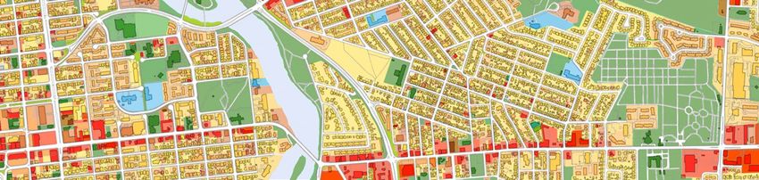
PLAN DE CONCEPTION                         BEECHWOOD
                                         COMMUNAUTAIRE DE BEECHWOOD                 COMMUNITY DESIGN PLAN

                                          L’AVENUE BEECHWOOD AUJOURD’HUI       1.   BEECHWOOD TODAY

                                        Figure 1: Surrounding Neighbourhoods
                                        Figure 1 : Quartiers avoisinants

Existing wood-frame house on
Beechwood Avenue.
Maison à ossature de bois de l’avenue
Beechwood

                                                                                                            2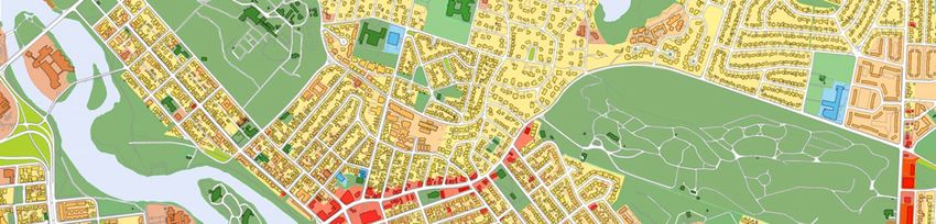
PLAN DE CONCEPTION                                                             BEECHWOOD
  COMMUNAUTAIRE DE BEECHWOOD                                                     COMMUNITY DESIGN PLAN

  L’AVENUE BEECHWOOD AUJOURD’HUI                                       1.        BEECHWOOD TODAY

ANALYSE COMMUNAUTAIRE                                                  1.1.0   COMMUNITY ANALYSIS
                                                                                                                                                    1    BEECHWOOD TODAY
                                                                                                                                                         L’AVENUE BEECHWOOD
LE SECTEUR D’AMÉNAGEMENT                                               1.1.1   THE PLANNING AREA                                                         AUJOURD’HUI
Le secteur visé s’étend sur environ 1,1 kilomètre de l’avenue                  The Planning Area extends approximately 1.1 kilometers along
Beechwood, depuis le pont St-Patrick jusqu’à l’entrée du                       Beechwood Avenue from the St. Patrick Street Bridge to the           2    PLANNING FRAMEWORK
cimetière Beechwood. Il est délimité au nord et au sud par toutes              entrance to the Beechwood Cemetery. The north and south                   LA STRATÉGIE
                                                                               boundaries include all the properties that front on Beechwood             D’AMÉNAGEMENT
les propriétés dont la façade donne sur l’avenue Beechwood (à
l’exception de quelques biens-fonds isolés du secteur de                       Avenue, (except for a few isolated properties in the Rockcliffe
                                                                               Park area) and, other abutting properties immediately behind         3    BEECHWOOD TOMORROW
Rockcliffe Park) ainsi que par d’autres propriétés attenantes                                                                                            L’AVENUE BEECHWOOD
situées immédiatement derrière celles donnant sur l’avenue.                    those that front on Beechwood Avenue.                                     DEMAIN

QUARTIERS AVOISINANTS                                                  1.1.2   SURROUNDING NEIGHBOURHOODS
Désignée « rue principale traditionnelle », l’avenue Beechwood                 As a traditional mainstreet, Beechwood Avenue is the local
est la rue commerciale locale qui sert les quartiers avoisinants               commercial street serving the surrounding neighbourhoods of
New Edinburgh, Rockcliffe Park, Lindenlea et Vanier.                           New Edinburgh, Rockcliffe Park, Lindenlea and Vanier.

D’autres districts et quartiers, bien qu’ils se trouvent un peu plus           Other districts and neighbourhoods, which are further away, are
loin, font aussi partie de la zone d’influence de l’avenue                     still within the sphere of influence of Beechwood Avenue.
Beechwood. La figure 1 illustre les quartiers avoisinants et la                Figure 1 shows the surrounding neighbourhoods and the broader
vaste aire de services et de commodités comprise dans le secteur               market area for the services and amenities in the Planning Area.
visé. Les données démographiques qui figurent dans ce document                 The demographic information presented in this Plan is derived
ont été recueillies pour l’ensemble du secteur, lequel couvre un               from this broader area which is an approximate 2-kilometre
rayon d’à peu près deux kilomètres de l’avenue Beechwood.                      radius surrounding Beechwood Avenue.

                                                                                                                                                  Beechwood Promenade
                                                                                                                                                  Promenade sur l’avenue Beechwood

  Figure 2: The Planning Area
  Figure 2 : Le secteur d’aménagement

                                                                                                                                             3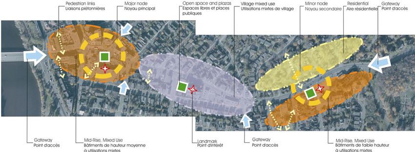
PLAN DE CONCEPTION                                                                      BEECHWOOD
                                    COMMUNAUTAIRE DE BEECHWOOD                                                              COMMUNITY DESIGN PLAN

                                    L’AVENUE BEECHWOOD AUJOURD’HUI                                                1.        BEECHWOOD TODAY

                                  PARTICIPATION DU PUBLIC                                                         1.1.3   PUBLIC INVOLVEMENT
                                  Le Plan a été préparé en consultation régulière avec des dirigeants                     The preparation of this Plan involved on-going consultation with
                                  communautaires et des chefs d’entreprises dévoués ainsi qu’avec                         dedicated business and community leaders and the public at
                                  le grand public. Les renseignements pertinents ont été                                  large. Communication with the public occurred through the
                                  communiqués à la population au moyen du site Web de la Ville et                         City’s website and various community meetings and workshops.
                                  de divers ateliers et réunions communautaires tenus sur le sujet.                       The project was guided by a Steering Committee made up of
                                  Le projet a été mené par un Comité directeur composé de                                 representatives from local business and the surrounding
                                  représentants du milieu des affaires et de la communauté ainsi                          community and the two local City Councilors. A Technical
                                  que des deux conseillers municipaux concernés. Un Comité                                Advisory Committee was also established to respond to specific
                                  consultatif technique a également été mis sur pied pour répondre                        technical and design issues. The main consultation events
Design Workshop                   à des questions précises sur les plans technique et conceptuel. Les                     included:
Atelier de l’aménagement          principales activités de consultation organisées ont été les
                                  suivantes :                                                                                 Design Workshop (April 19, 2005)
                                                                                                                              Public Open House - public input on ideas from the Design
                                    atelier sur l'aménagement de l'avenue Beechwood (le 19 avril 2005)                        Workshop (April 30, 2005)
                                    séance de consultation publique – commentaires des résidents sur les                      Walking Tour (June 2, 2005)
                                    idées formulées lors de l’atelier sur l’aménagement de l’avenue
                                                                                                                              Community Information Session - planning and design
                                    Beechwood (le 30 avril 2005)
                                    visite à pied (le 2 juin 2005)                                                            proposals (October 5, 2005)
                                    séance de consultation publique – propositions d’aménagement et de                        Community Information Session - traffic and parking
                                    conception (le 5 octobre 2005)                                                            proposals (January 19, 2006)
                                    séance de consultation publique – propositions relatives à la circulation                 Community Information Session – the Community Design
                                    et au stationnement (le 19 janvier 2006)                                                  Plan, the Official Plan Amendment and the list of zoning
                                    séance de consultation publique – Plan de conception communautaire,                       changes (July 5, 2006)
Public Open House                   modification au Plan officiel et liste de changements de zonage (le
Séance de consultation publique     5 juillet 2006)

                                  ATELIER SUR L’AMÉNAGEMENT ET VISITE À PIED                                      1.1.4   THE DESIGN WORKSHOP AND WALKING TOUR
                                  Les principaux commentaires retenus pour le projet, formulés à                          The following are the main comments made at the Design
                                  l’occasion de l’atelier sur l’aménagement et de la visite à pied,                       Workshop and the Walking Tour:
                                  portaient sur les aspects suivants :
                                                                                                                              For planning purposes, Beechwood Avenue should be
                                    Aux fins de l’aménagement, l’avenue Beechwood devrait être divisée                        treated as three or four distinct sectors.
                                    en trois ou quatre tronçons.                                                              The natural topography and the curved nature of
                                    La topographie naturelle et les courbes de l’avenue offrent des
                                                                                                                              Beechwood Avenue create unique vistas.
                                    panoramas uniques.
                                    Les petits bâtiments de trois étages sont privilégiés, mais les édifices de               Small 3-storey buildings are preferred, with 4 to 6-storey
                                    quatre à six étages devraient être permis à certains endroits                             buildings allowed at strategic locations.
                                    stratégiques.                                                                             One-storey plazas should not be allowed.
                                    Les centres commerciaux à un étage devraient être interdits.                              The Crichton/Vanier Parkway and the Marier/Putman
Walking Tour                        Les intersections de la rue Crichton et de la promenade Vanier ainsi                      intersections should be improved.
                                    que des avenues Marier et Putman devraient être améliorées.
Visite à pied

                                                                                                                                                                                        4
PLAN DE CONCEPTION                                                            BEECHWOOD
 COMMUNAUTAIRE DE BEECHWOOD                                                    COMMUNITY DESIGN PLAN

  L’AVENUE BEECHWOOD AUJOURD’HUI                                       1.      BEECHWOOD TODAY

 • Il faudrait améliorer les voies cyclables entre le pont                       Improve the cycling links between St. Patrick’s Bridge and
   St-Patrick et le chemin Hemlock.                                              Hemlock Avenue.
 • Un carrefour giratoire devrait être aménagé et servir de point                A traffic circle should be created as a gateway feature at
   d’accès au cimetière Beechwood.                                               Beechwood Cemetery.
 • L’espace vert situé devant l’église St-Charles devrait servir à               The greenspace in front of St. Charles Church should be
   l’aménagement d’un lieu public.                                               enhanced for public purposes.
 • On propose de construire un restaurant du genre « Ritz » le                   A Ritz-style restaurant should be established along the River
   long de la rivière, près du pont St-Patrick.                                  at St. Patrick’s Bridge.
 • Le parc Genest devrait être relié à l’avenue Beechwood.                       Genest Park should be linked to Beechwood Avenue.

SÉANCE DE CONSULTATION PUBLIQUE                                         1.1.5 THE PUBLIC OPEN HOUSE                                              Video Mondo Building
Les principales observations formulées à la séance de                        The following are the main comments made by the public at the       Bâtiment abritant le commerce
consultation publique sont les suivantes :                                   Open House:                                                         Video Mondo

 • tenir compte du fait que l’avenue Beechwood est prisée des                    Beechwood Avenue is well used by local residents and is
   résidents des quartiers avoisinants en raison de son grand                    known for its variety and diversity of shops.
   éventail de commerces.                                                        The empty buildings and poorly maintained properties need
 • prendre les mesures qui s’imposent relativement aux                           to be improved and infill development should be promoted.
   bâtiments vides et aux propriétés mal entretenues, et                         Small village-style buildings are preferred.
   encourager l’aménagement intercalaire.                                        Low-rise building heights are preferred with medium-rise
 • privilégier les bâtiments semblables à ceux que l’on trouve                   buildings at strategic locations.
   dans les villages.                                                            Comprehensive streetscape improvements are needed.
 • opter pour des bâtiments de faible hauteur, mais permettre                    Parking should be retained along the street and placed
   les édifices de hauteur moyenne à certains endroits                           behind buildings.
   stratégiques.                                                                 Additional trees and landscaping would improve the street.
 • améliorer de façon générale le paysage de rue.                                Hydro poles and wires should be removed, if possible.
 • conserver les places de stationnement sur rue et aménager                     The following are significant buildings: St. Charles Church,
   des terrains de stationnement à l’arrière des bâtiments.                      El Meson Restaurant, the Second Cup and 81 Beechwood.
 • embellir la rue par la plantation d’arbres et des
   aménagements paysagers.
 • enlever les fils et les poteaux électriques là où il est possible
   de le faire.
 • tenir compte du fait que l’église St-Charles, le restaurant El
   Meson, le café Second Cup et le 81 de l’avenue Beechwood
   sont des bâtiments d’intérêt.

                                                                                                                                            5
PLAN DE CONCEPTION                                                             BEECHWOOD
                              COMMUNAUTAIRE DE BEECHWOOD                                                     COMMUNITY DESIGN PLAN

                              L’AVENUE BEECHWOOD AUJOURD’HUI                                       1.        BEECHWOOD TODAY

                            CONTEXTE HISTORIQUE                                                    1.1.6   HISTORICAL CONTEXT
                            Le comté de Carleton est arpenté pour la première fois en 1799.                Carleton County was first surveyed in 1799. In 1832 Thomas
                            En 1832, Thomas MacKay divise les terrains entourant l’avenue                  MacKay subdivided the land around Beechwood Avenue into
                            Beechwood en grandes parcelles qu’il baptise « MacKay                          large parcels, which were originally called the MacKay Estates.
                            Estates » (propriétés MacKay). Dans les années 1880, on retrouve               By the 1880’s, a number of homes and businesses were built on
                            un certain nombre de maisons et de commerces sur le côté nord                  the north side of Beechwood Avenue and along its side streets.
                            de l’avenue et le long de ses rues transversales. Le gouvernement              As the Canadian government grew in importance, the area
                            du Canada prenant de l’ampleur, les fonctionnaires fédéraux et les             became home to federal and Foreign Service workers. By the
                            membres du Service extérieur s’établissent de plus en plus dans le             1890s, development started on the south side of Beechwood
                            secteur. Environ une décennie plus tard, des projets                           Avenue, which was part of the small but separate community of
El Meson Restaurant
                            d’aménagement voient le jour du côté sud de l’avenue, qui fait                 Clarkstown. It originally developed, principally as a francophone
Restaurant el Meson
                            partie de la petite communauté de Clarkstown. Ce quartier                      community, with residents migrating from Lowertown and from
                            majoritairement francophone s’est formé de personnes ayant                     various communities in Quebec.
                            quitté la Basse-Ville et diverses localités du Québec pour s’établir
                            dans les environs.                                                             Beechwood Avenue was first built as a winding dirt road to
                                                                                                           Beechwood Cemetery and, at the time, was referred to as “the
                            Chemin de terre en lacets aménagé à l’origine pour donner accès                road to Beechwood Cemetery” and later, “Beechwood Cemetery
                            au cimetière Beechwood, l’avenue portait, à l’époque de sa                     Road”. The Hemlock extension, which linked Beechwood
                            construction, le nom de « route menant au cimetière                            Avenue to St. Laurent Boulevard, was built later. Prior to the
                            Beechwood », avant d’être appelée « chemin du cimetière                        2001 municipal amalgamation, Beechwood Avenue marked the
                            Beechwood ». C’est seulement plus tard que son prolongement, le                boundary between three former municipalities: to the north, the
                            chemin Hemlock, a permis de relier l’avenue Beechwood au                       City of Ottawa and the Village of Rockcliffe Park and, to the
                            boulevard St-Laurent. Avant la fusion de 2001, cette artère                    south, the City of Vanier. Beechwood Avenue, itself, was
L’avenue Beechwood Avenue                                                                                  designated as a regional road, under the jurisdiction of the former
                            délimitait trois municipalités : la ville d’Ottawa et le village de
                            Rockcliffe Park au nord, et la ville de Vanier au sud. L’avenue                Regional Municipality of Ottawa-Carleton.
                            Beechwood a été désignée « route régionale » par l’ancienne
                            Municipalité régionale d’Ottawa-Carleton.                                      Beechwood’s rich history is revealed by the style of the older
                                                                                                           buildings scattered throughout the Planning Area. St. Charles
                            Les vieux bâtiments au style particulier que l’on trouve un peu                Church, El Meson Restaurant and the Video Mondo building at
                            partout dans le secteur d’aménagement témoignent de la riche                   117 Beechwood Avenue reflect the street’s village character.
                            histoire de l’avenue Beechwood. L’église St-Charles, le                        Although there are no individually designated buildings in the
                            restaurant El Meson et l’édifice du commerce Video Mondo sis                   Planning Area, the entire Rockcliffe Park area is designated as a
                            au 117 de l’avenue Beechwood rappellent les anciennes rues de                  Heritage Conservation District and numerous other buildings in
                            village. Bien qu’aucun édifice ne possède de désignation                       the Planning Area are on the Heritage Reference List. Refer to
                            patrimoniale dans le secteur visé, l’ensemble de Rockcliffe Park               Figure 6.
                            est désigné district de conservation du patrimoine et de nombreux
                            autres bâtiments du secteur figurent sur la liste de référence des
L’avenue Beechwood Avenue   biens patrimoniaux (se reporter à la figure 6).

                                                                                                                                                                            6
PLAN DE CONCEPTION BEECHWOOD
COMMUNAUTAIRE DE BEECHWOOD COMMUNITY DESIGN PLAN
L’AVENUE BEECHWOOD AUJOURD’HUI 1. BEECHWOOD TODAY
DÉMOGRAPHIE 1.1.7 DEMOGRAPHICS
À de nombreux égards, le secteur visé ressemble à bien d’autres In many respects, the area is typical of many other inner-city Census *Age Group
quartiers urbains d’Ottawa. Depuis 1971, l’aire couvrant un rayon areas in Ottawa. Since 1971, the 2-kilometre radius around Year
Population
Percentages Dwellings
Année de *Groupes d’âge (%) Nombre
de deux kilomètres autour de l’avenue Beechwood a connu divers Beechwood Avenue has undergone changes highlighted by the recensement d’habitations
changements, les principaux étant les suivants : following:
entre 1971 et 1981, la population a diminué de 1971 35,870 (34%, 47%, 19%) 11,045
7 000 personnes, même si le nombre d’habitations Between 1971 and 1981, the population shrank by 7,000 1976 30,720 (29%, 49%, 22%) 11,050
unifamiliales a augmenté de 820. despite the fact that dwelling units increased by 820.
1981 28,710 (25%, 51%, 24%) 11,865
entre 1981 et 2001, aucun changement démographique n’a été Between 1981 and 2001, the total population did not change
noté bien que le nombre d’habitations unifamiliales se soit despite the fact that the number of dwelling units increased 1986 30,435 (20%, 55%, 25%) 12,220
accru de 1 680. by 1,680 units. 1991 29,040 (20%, 56%, 23%) 13,000
la population d’enfants a diminué de 15 p. 100 entre 1971 et The number of children making up the total population
1986 et s’est stabilisée entre 1986 et 2001, la baisse étant declined by 15% between 1971 and 1986 and stabilized 1996 28,065 (20%, 55%, 25%) 12,765
attribuable au fait que de nombreuses familles avec enfants between 1986 and 2001. This decline was due to the 2001 28,835 (19%, 56%, 25%) 13,545
avaient quitté le secteur pour s’établir dans les banlieues. migration of families with young children to the suburbs.
2006** 30,832 - 14,943
on prévoit que le nombre de personnes par ménage demeurera It is anticipated that the number of persons per household
faible alors que le nombre d’habitations unifamiliales will remain low while the number of dwellings will 2011** 31,078 - 15,441
continuera de croître. continue to increase. 2021** 30,700 - 16,260
*(Youth 0-19, Adults 20-54, Seniors 55+)
UTILISATIONS DU SOL EXISTANTES 1.1.8 EXISTING LAND USE *(jeunes de 19 ans et moins, adultes de 20 à 54 ans, aînés
de 55 ans et plus)
Les terrains qui jouxtent l’avenue Beechwood servent à des fins The lands that abut Beechwood Avenue are used for a variety of
diverses, notamment les suivantes : purposes including: **Projection by Statistics Canada
**Prévisions de Statistique Canada
commerces de détail;
bureaux commerciaux à utilisations mixtes (dans le même Personal service and medical uses (optometrist office,
édifice) investment office, veterinary clinic) Figure 3: Demographic Data for the
services personnels et médicaux (oculistes, planificateurs Residential (homes and apartments and residential, usually surrounding 2-kilometer area.
financiers, clinique vétérinaire, etc.) upstairs, mixed in the same building as other uses)
Figure 3 : Données démographiques
zones résidentielles (maisons et appartements, habituellement Public and recreational uses (park, church, fire station, d’un rayon de deux kilomètres
aux étages supérieurs de bâtiments ayant d’autres utilisations) ; cemetery)
utilisations publiques et récréatives (parc, église, caserne de
pompiers, cimetière, etc.) The land in the surrounding community is mainly used for
residential purposes. In Rockcliffe Park, the type of residential is
Les terrains des quartiers avoisinants servent principalement à des predominantly low-density single homes. In Lindenlea, New
fins résidentielles. Dans Rockcliffe Park, le zonage permet des Edinburgh and Vanier the type ranges from low-density single
maisons unifamiliales et une faible densité de l’aménagement. À homes to medium-density apartments. There are also high-
Lindenlea, à New Edinburgh et à Vanier, on trouve des secteurs density, high-rise apartments at various locations within the 2-
résidentiels à faible densité où sont construites des maisons kilometre radius.
unifamiliales ainsi que des zones d’appartements à densité
moyenne. De plus, certains endroits situés à l’intérieur du rayon
de deux kilomètres entourant l’avenue comportent des zones à
densité élevée avec tours d’habitation.
7PLAN DE CONCEPTION BEECHWOOD
COMMUNAUTAIRE DE BEECHWOOD COMMUNITY DESIGN PLAN
L’AVENUE BEECHWOOD AUJOURD’HUI 1. BEECHWOOD TODAY
Figure 4: Land Use Map
Figure 4 : Carte des utilisations du sol
Residential / Résidentielle
Mixed Use / Usage mixte
Institutional / Institutionelle
Open Space / Espace ouverte
8PLAN DE CONCEPTION BEECHWOOD
COMMUNAUTAIRE DE BEECHWOOD COMMUNITY DESIGN PLAN
L’AVENUE BEECHWOOD AUJOURD’HUI 1. BEECHWOOD TODAY
ANALYSE DE LA CONCEPTION URBAINE 1.2.0 URBAN DESIGN ANALYSIS
SECTEURS D’INTÉRÊT 1.2.1 SECTORS
L’ensemble de l’avenue Beechwood consiste en une rue Beechwood Avenue, in its entirety, is a mainstreet that serves as 1 BEECHWOOD TODAY
principale que les résidents des divers quartiers avoisinants the local shopping area and the central meeting place for a L’AVENUE BEECHWOOD
fréquentent pour faire des courses ou rencontrer d’autres diverse group of surrounding neighbourhoods. It makes sense AUJOURD’HUI
personnes. Sur le plan du marketing et des affaires, il est logique from a marketing and business perspective that the street be seen
de traiter l’avenue comme faisant partie d’un tout, c’est-à-dire as a single unit with a design that is consistent and reflects this 2 PLANNING FRAMEWORK
LA STRATÉGIE
une rue qui présente des éléments de conception uniformes mais diversity of uses. D’AMÉNAGEMENT
tenant compte de sa diversité.
However, there are sectors of the street with different 3 BEECHWOOD TOMORROW
Cependant, certains tronçons possèdent des caractéristiques characteristics that people in the community recognize and L’AVENUE BEECHWOOD
prisées des membres de la communauté, comme l’architecture de appreciate, for instance, the village-style architecture reflected in DEMAIN
style villageois que l’on trouve dans le tronçon central, l’éventail the middle sector, the concentrated range of small shops in the
de petites boutiques regroupées dans l’ouest et l’aspect résidentiel west sector, and the residential nature of the east sector. Figure 5
de l’est. La figure 5 illustre quelques-uns des points d’intérêt de illustrates some of the different sectors of Beechwood Avenue as
l’avenue Beechwood, recensés à l’atelier sur l’aménagement. identified at the Design Workshop.
Figure 5: Urban Design Analysis (from the April, 2005 Design Workshop)
Figure 5 : Analyse de la conception urbaine (de l’atélier de conception d’avril 2005)
9PLAN DE CONCEPTION BEECHWOOD
COMMUNAUTAIRE DE BEECHWOOD COMMUNITY DESIGN PLAN
L’AVENUE BEECHWOOD AUJOURD’HUI 1. BEECHWOOD TODAY
NOYAUX 1.2.2 NODES
D’après le Plan officiel de la Ville, les plans de conception The City’s Official Plan suggests that Community Design Plans
communautaire devraient définir les noyaux comme des endroits should identify nodes as places for further intensification. This is
propices à la densification. Il s’agit d’une pratique utile aux fins useful for planning purposes, as most successful mainstreets in
de l’aménagement, car la plupart des rues principales les plus Ottawa are concentrated along a small segment of a longer street.
dynamiques d’Ottawa consistent en de petits tronçons de longues The portion of Bank Street in the Glebe and the portion of
rues. Parmi les exemples de rues principales achalandées, notons Montreal Road in the heart of Vanier are examples.
la rue Bank dans le Glebe et la section du chemin Montréal qui
traverse le cœur de Vanier. These nodes can be existing places or new places. Existing nodes
can be identified by analyzing the present differences in the form
Les noyaux sont des endroits existants ou nouveaux. Les noyaux and intensity of development within an area. New nodes may be
Existing Building in Major Node
Bâtiment existant dans un noyau existants peuvent être recensés par une analyse des écarts actuels identified by analyzing the nature of underutilized areas for their
principal entre la forme et la densité de l’aménagement dans un secteur suitability for additional development. Figure 5 illustrates two
donné. Les nouveaux noyaux peuvent pour leur part être cernés nodes as identified at the Design Workshop.
en étudiant la nature des zones sous-utilisées afin de déterminer si
elles peuvent accueillir d’autres projets d’aménagement. La
figure 5 montre un noyau principal et un noyau secondaire
désignés à l’atelier sur l’aménagement.
POINTS D’ACCÉS 1.2.3 GATEWAYS
Généralement, la première impression qu’ont les visiteurs d’un First impressions of Beechwood Avenue are often formed at the
lieu, en l’occurrence l’avenue Beechwood, repose en grande main entry locations, or gateways to the street. These are the
partie sur ses principaux points d’accès, ces éléments qui, en plus most traveled and visible places and they present opportunities to
d’être les endroits les plus fréquentés et visibles, peuvent être mis establish entry features such as signs, public art, street furniture
en valeur, que ce soit par des panneaux, des œuvres d’art public, or other urban elements that have been designed especially for
Eastern gateway un mobilier urbain ou d’autres éléments urbains conçus Beechwood Avenue. Figure 5 illustrates the five most important
Point d’accès à l’extrémité est spécialement pour l’avenue Beechwood. La figure 5 montre les gateways to Beechwood Avenue.
cinq principaux points d’accès à l’avenue Beechwood.
ROUTE EN LACETS 1.2.4 WINDING ROAD
L’avenue Beechwood est la seule rue principale traditionnelle Beechwood Avenue is the only traditional mainstreet in Ottawa
d’Ottawa qui ne soit pas droite : elle compte quelques virages that is not straight. It winds its way from Charlevoix Street in the
depuis la rue Charlevoix, à l’ouest, jusqu’au cimetière west to Beechwood Cemetery in the east. The nature of a
Beechwood, à l’est. Par définition, une route en lacets offre des winding road is that it presents views that change as one travels
points de vue différents selon l’endroit où l’on se trouve et along it and presents buildings that only appear once you round a
comporte des bâtiments qui n’apparaissent qu’après avoir pris un corner. Eye-catching architecture in association with this element
tournant. Ajoutée à cet élément de surprise, une architecture of surprise can greatly enhance the experience of traveling along
accrocheuse peut rehausser grandement le paysage de rue. De a street. As such, it is possible to identify places that are more
fait, il est possible de cerner des lieux plus visibles que d’autres et visible than others and places where eye-catching architecture
Winding Road des endroits où l’ajout d’éléments d’architecture attrayants could enhance the street.
Route en lacets pourrait rehausser le paysage de rue.
10PLAN DE CONCEPTION BEECHWOOD
COMMUNAUTAIRE DE BEECHWOOD COMMUNITY DESIGN PLAN
L’AVENUE BEECHWOOD AUJOURD’HUI 1. BEECHWOOD TODAY
ESPACES LIBRES ET PLACES PUBLIQUES 1.2.5 OPEN SPACES AND PLAZA’S
Il existe deux espaces libres importants à chaque extrémité du There are two significant open spaces at either end of the
secteur visé. À l’extrémité ouest se trouve la rivière Rideau, Planning Area. At the west end is the Rideau River and the
bordée de terrains à vocation de parc, et à l’extrémité est, le parkland that runs beside it. At the east end is Beechwood
cimetière Beechwood aux allures de forêt depuis son entrée Cemetery, which has the appearance of a forest from the
jusqu’au boulevard St-Laurent. Les participants à l’atelier sur Cemetery entrance to St. Laurent Boulevard. Between the two
l’aménagement ont proposé de créer entre les deux espaces des features, three locations were identified at the Design Workshop
places publiques à trois endroits (se reporter à la figure 5). as having potential to be plaza-style open spaces.
POINTS D’INTÉRÊT 1.2.6 LANDMARKS The Rideau River shore
Bien que le secteur visé présente plusieurs constructions While there are a number of eye-catching, village-style buildings Rive de la rivière Rideau
attrayantes qui rappellent les villages, il ne comporte qu’un seul in the Planning Area, there is only one significant landmark
bâtiment d’intérêt notable : l’église St-Charles. À l’atelier sur building – St. Charles Church. At the Design Workshop
l’aménagement, les participants ont suggéré deux autres endroits preferred locations were identified for two other landmark
privilégiés où prévoir des points d’intérêt, ce qui signifierait que buildings, resulting in one landmark building being located in
les trois secteurs auraient chacun le leur (se reporter à la figure 5). each of the three sectors. Refer to Figure 5.
LIAISONS PIÉTONNIERES 1.2.7 PEDESTRIAN LINKS
Par ailleurs, il est proposé d’aménager au milieu des îlots des There is a need to establish mid-block connections linking
liaisons entre l’avenue Beechwood et les parcs, les rues et les Beechwood Avenue with parks, parking lots and streets to the
terrains de stationnement situés à l’arrière des constructions rear. This is particularly true for the larger blocks of land that
donnant sur l’avenue. Cette mesure est particulièrement abut Beechwood Avenue. Some of the pedestrian links that were
nécessaire dans le cas des gros îlots qui jouxtent l’avenue identified at the Design Workshop are illustrated in Figure 5.
Beechwood. La figure 5 illustre quelques-unes des liaisons St. Charles Church as a landmark
piétonnières suggérées à l’atelier sur l’aménagement. building.
L’église St-Charles, bâtiment d’intérêt
FORÊTS URBAINES 1.2.8 URBAN FOREST
Le secteur de l’avenue Beechwood compte un nombre There are a significant number of trees that have thrived in spite
considérable d’arbres malgré la quantité de sel épandu dans la rue of the road salt and the sometimes-harsh mainstreet environment.
et les conditions parfois difficiles que subit l’environnement de Locust are the predominant tree species which are mainly on the
cette rue principale. L’essence d’arbre la plus commune dans le south side of the street from the Vanier Parkway to the
secteur, le robinier, se retrouve principalement sur le côté sud de Rockcliffe Apartments with noticeable concentrations in front of
la rue, de la promenade Vanier aux appartements Rockcliffe. On the Loeb and in front of the vacant lot at the southeast corner of
en trouve également un grand nombre face au Loeb et sur la Jolliet and Beechwood Avenues. Other stands of trees include
partie avant du lot vacant situé à l’angle sud-est des avenues mature maple surrounding the front green space in front of St.
Jolliet et Beechwood. Parmi les autres peuplements d’arbres du Charles Church and significant mixed tree cover in the
secteur, mentionnons les érables arrivés à maturité qui encerclent Rockcliffe Park area. Many residences have trees and other
l’espace vert devant l’église St-Charles et le grand couvert vegetation as a screen between their homes and Beechwood Locust trees on Beechwood
forestier mixte dans Rockcliffe Park. Enfin, de nombreux Avenue. Robiniers sur l’avenue Beechwood
propriétaires résidentiels ont planté des arbres ou d’autres
végétaux qui servent d’écran entre leur maison et l’avenue
Beechwood.
11PLAN DE CONCEPTION BEECHWOOD
COMMUNAUTAIRE DE BEECHWOOD COMMUNITY DESIGN PLAN
L’AVENUE BEECHWOOD AUJOURD’HUI 1. BEECHWOOD TODAY
CARACTÉRISTIQUES TOPOGRAPHIQUES 1.2.9 TOPOGRAPHIC FEATURES
Deux caractéristiques topographiques donnent l’impression que There are two topographic features that give Beechwood a sense
l’avenue Beechwood se trouve au pied d’une pente : d’une part, of being at the bottom of a slope: the first is the sharp escarpment
l’escarpement abrupt, qui donne une idée de l’élévation, depuis that defines the rise in elevation starting at the entry to
l’entrée du cimetière Beechwood jusqu’au chemin Hemlock; Beechwood Cemetery and continuing along Hemlock; and the
d’autre part, une pente plus graduelle au nord de l’avenue second is a more gradual rise in elevation north of Beechwood
Beechwood qui se prolonge jusqu’à Rockcliffe Park et à des into Rockcliffe Park and parts of Lindenlea and New Edinburgh.
portions de Lindenlea et de New Edinburgh. Ce changement de This change in elevation is noticeable traveling south along
dénivellation peut être observé lorsqu’on se déplace en direction Springfield Road towards Beechwood. There is also a sense of
sud le long de la promenade Springfield vers l’avenue descent from St. Patrick’s Bridge on the approach to Beechwood
Beechwood. À l’approche de celle-ci, on a l’impression que la rue Avenue, adding to the perspective that the Vanier Parkway
s’abaisse depuis le pont St-Patrick, ce qui contribue à faire de intersection is a gateway location.
l’intersection de la promenade Vanier un point d’accès au secteur
visé.
MURALES 1.2.10 WALL MURALS
Au cours des dix dernières années, un certain nombre de murales Over the past decade a number of wall murals have been either
ont été peintes ou installées sur des bâtiments du secteur painted or mounted on buildings in the Planning Area. Many of
d’aménagement. Bon nombre d’entre elles illustrent des them portray historical events or common traditions from the
événements historiques ou des traditions communes du passé. Ces past. These murals add colour to Beechwood Avenue.
murales ajoutent de la couleur à l’avenue Beechwood.
Mural located on the west-facing wall of the Loeb Building
Murale installée sur le mur ouest du Loeb
12PLAN DE CONCEPTION BEECHWOOD
COMMUNAUTAIRE DE BEECHWOOD COMMUNITY DESIGN PLAN
L’AVENUE BEECHWOOD AUJOURD’HUI 1. BEECHWOOD TODAY
BÂTIMENTS PATRIMONIAUX 1.2.11 HERITAGE BUILDINGS
On trouve dans le secteur d’aménagement et ses environs trois There are three categories of buildings of heritage interest in and
catégories de bâtiments à valeur patrimoniale qui témoignent de around the Planning Area. This is a reflection of the rich history
la riche histoire du quartier. of the area.
La seule construction désignée « bâtiment patrimonial » aux The only individually designated building under the Ontario
termes de la Loi sur le patrimoine de l'Ontario est l’église Heritage Act is “l’école St-Charles” which is located just
St-Charles, qui est située aux limites du secteur outside the Planning Area.
d’aménagement. The entire area within the former Village of Rockcliffe Park
L’ensemble du secteur correspondant à l’ancien Village de is designated as a Heritage District under the Ontario
Rockcliffe Park est désigné « district de conservation du Heritage Act.
patrimoine » aux termes de la Loi sur le patrimoine de There are numerous buildings in the Planning Area listed on
l’Ontario. the Heritage Reference List.
Le secteur d’aménagement comprend de nombreux bâtiments L’école St-Charles School
qui figurent sur la liste de référence des biens patrimoniaux. 24 chemin Springfield Road
24 chemin Springfield Road Black/Noir
(24 chemin Springfield Road)
Designated heritage building
Construction désignée
« bâtiment patrimonial »
Green/Vert
Rockcliffe Park Heritage
Conservation District
District de conservation du
patrimoine de Rockcliffe Park
Red/Rouge
Buildings on the Heritage
Reference List
Bâtiments figurant sur la liste
de référence des biens
patrimoniaux
Figure 6: Heritage Buildings
Figure 6 : Bâtiments patrimoniaux
13PLAN DE CONCEPTION BEECHWOOD
COMMUNAUTAIRE DE BEECHWOOD COMMUNITY DESIGN PLAN
L’AVENUE BEECHWOOD AUJOURD’HUI 1. BEECHWOOD TODAY
ANALYSE DU PAYSAGE DE RUE ET DES COULOIRS DE 1.3.0 STREETSCAPE AND CORRIDOR ANALYSIS
1 BEECHWOOD TODAY
CIRCULATION
L’AVENUE BEECHWOOD
CLASSIFICATION DES ROUTES 1.3.1 ROAD CLASSIFICATION AUJOURD’HUI
Toutes les rues principales qui se trouvent à l’intérieur et à All of the main roads in and around the Planning Area are
l’extérieur du secteur d’aménagement ont été classées dans des classified from a functional perspective in the City’s Official 2 PLANNING FRAMEWORK
catégories selon leur fonction dans le Plan officiel de la Ville Plan (2003). Beechwood Avenue is classified as both an Arterial LA STRATÉGIE
D’AMÉNAGEMENT
(2003). L’avenue Beechwood est désignée à la fois « artère » et Road and a Traditional Mainstreet and the associated Official
« rue principale traditionnelle », et les politiques du Plan officiel Plan policies apply in relation to mainstreets, transportation
3 BEECHWOOD TOMORROW
associées à ces désignations s’appliquent en ce qui touche les rues demand management, walking, cycling, transit, right-of-way L’AVENUE BEECHWOOD
principales, la gestion de la demande en transport, la marche, le protection and parking. In addition, the following road DEMAIN
cyclisme, le transport en commun, la protection de l'emprise classifications are relevant to this Plan:
routière et le stationnement. En outre, le présent plan prévoit
attribuer les classifications de route suivantes : The Hemolck-Beechwood-St. Patrick corridor has an added
Le couloir Hemlock–Beechwood–St-Patrick comporte la designation as a Cycling Route.
désignation supplémentaire de « voie cyclable ». The Vanier Parkway-St.Patrick corridor has an added
Le couloir de la promenade Vanier et de la rue St-Patrick designation as a Scenic Entry Route.
comporte la désignation supplémentaire de « voie d’accès The Rideau-Montreal Road corridor is classified as an
panoramique ». Arterial Road, a Traditional Mainstreet and a Future Transit
Le couloir Rideau-Montréal est désigné « artère », « rue Route (for light rail).
principale traditionnelle » et « futur couloir de transport en
commun » (train léger).
LARGEUR DES ROUTES ET PROTECTION DES EMPRISES 1.3.2 ROAD WIDTHS AND RIGHT-OF-WAY PROTECTION
À l'heure actuelle, la largeur de la chaussée asphaltée mesure de The existing paved roadway ranges from approximately 10.0
10 à 15,5 mètres environ; elle atteint son maximum à la hauteur metres to 15.5 metres in width. The paved area is widest at the
du pont St-Patrick et diminue vers l’est. Le nombre de voies varie St. Patrick Street Bridge and generally narrows to the east. The
de deux à quatre, sans compter les voies de virage à gauche et les number of lanes ranges from two to four not including left turn Beechwood near Crichton.
and merge lanes. The road was last rebuilt as part of the City’s Beechwood près de Crichton
voies convergentes. Les derniers travaux de reconstruction de la
chaussée ont été réalisés vers le milieu des années 1980 dans le regular road maintenance program in the mid-1980’s.
cadre du programme d’entretien des routes de la Ville
The right-of-way is the land owned by the City that provides the
Les emprises routières sont les terrains appartenant à la Ville et road, the sidewalk and boulevard. The existing right-of-way
destinés à l'aménagement de routes, de trottoirs et d’accotements. width varies from between 17.5 metres and 27.5 metres. Some of
À l’heure actuelle, la largeur des emprises va de 17,5 à the stone retaining walls located in the front yard of properties in
27,5 mètres. Certains murs de soutènement en pierre situés à Rockcliffe Park, are within the right-of-way. The “Protected”
l’avant de propriétés dans Rockcliffe Park se trouvent dans right-of-way width as established in the City’s Official Plan, is
l’emprise.. Dans le Plan officiel, la largeur de l’emprise entre le 23 m between the St. Patrick Street Bridge and Jolliet Street and
pont St-Patrick et l’avenue Jolliet est établie à 23 mètres et celle 26 m between Jolliet Street and Juliana Street. The implication of
entre l’avenue Jolliet et le chemin Juliana, à 26 mètres. De ce fait, this is that landowners may be required to dedicate a strip of land
les propriétaires fonciers seront peut-être tenus de céder à la Ville to the City as a condition of redevelopment. The City will use the
extra width for sidewalk or boulevard purposes, not for lane Beechwood near Loyer.
une bande de terrain. La Ville utilisera cette bande pour aménager
Beechwood près de Loyer
des trottoirs ou des accotements, mais pas pour élargir l’avenue. widening purposes.
15PLAN DE CONCEPTION BEECHWOOD
COMMUNAUTAIRE DE BEECHWOOD COMMUNITY DESIGN PLAN
L’AVENUE BEECHWOOD AUJOURD’HUI 1. BEECHWOOD TODAY
Figure 7: Road Classification
Figure 7 : Classification des routes
/ Artères
/ Biens-fonds fédéraux
/ Routes collectrices
/ Futur couloir
de transport en commun
/ Voies cyclables
16PLAN DE CONCEPTION BEECHWOOD
COMMUNAUTAIRE DE BEECHWOOD COMMUNITY DESIGN PLAN
L’AVENUE BEECHWOOD AUJOURD’HUI 1. BEECHWOOD TODAY
LE RÉSEAU ROUTIER DU POINT DE VUE DE LA 1.3.3 ROADS FROM AN URBAN DESIGN PERSPECTIVE
CONCDEPTION URBAINE There are three types of streets that stand out above the normal
Il existe trois types de rues non conventionnelles dans le secteur pattern of streets in the 2-kilometre radius of Beechwood
qui couvre un rayon de deux kilomètres de l’avenue Beechwood, Avenue. These streets are depicted on Figure 8.
lesquelles sont illustrées à la figure 8.
Rues principales : L’avenue Beechwood, le chemin Montréal et Mainstreets - Beechwood Avenue, Montreal Road and
la rue Rideau sont des rues principales traditionnelles urbaines Rideau Street are traditional inner-city mainstreets and
qui « relient » quartiers et secteurs entre eux. Les trois rues “seams” that bind neighbourhoods together. All three
sont très utilisées par les piétons, permettent divers types de exhibit high levels of pedestrian activity, multi-modal forms Sidewalk near Jolliet
déplacements et présentent des îlots de courte longueur dans of travel, a surrounding pattern of short blocks and an Trottoir près de l’avenue Jolliet
les secteurs environnants et un tissu urbain varié composé de intricate fabric of new and old buildings.
bâtiments vieux et récents. Distinctive Streets - some of Beechwood’s sidestreets have
Rues à caractère particulier : Certaines des voies publiques qui streetscapes that are more distinctive than others. This is due
débouchent sur l’avenue Beechwood offrent des paysages de to the relationship between the natural topography, the
rue fort particuliers. Ce fait s’explique par le lien entre la physical form of the street itself and the type of buildings
topographie, l’aspect physique de la rue et le type de bâtiments and open spaces that are located along it.
et d’espaces libres qui s’y trouvent. Parkways - the Vanier Parkway, the Rockcliffe Parkway
Promenades : La promenade Vanier, la promenade Rockcliffe and, to a lesser extent, Hemlock Avenue are sweeping,
et, dans une moindre mesure, le chemin Hemlock sont des rues limited access roads surrounded by green landscapes.
importantes à accès limité, entourées d’espaces verts.
The fact that Beechwood Avenue, as a mainstreet, meets a
Comme l’avenue Beechwood, en tant que rue principale, parkway-style street at both ends, accentuates that they are, not
rencontre des promenades à ses deux extrémités, ces carrefours only gateways, but places conducive to special treatment. In fact
deviennent non seulement des points d’accès à l’avenue, mais the place where Beechwood meets Hemlock is similar in nature
également des lieux propices aux aménagements particuliers. En to where the Rockcliffe Parkway meets Confederation
Sidewalk near Corona.
fait, le point de rencontre entre l’avenue Beechwood et le chemin Boulevard. It is at the latter location that the National Capital Trottoir près de l’avenue Corona
Hemlock rappelle celui de la promenade Rockcliffe et du Commission and the City of Ottawa have built a roundabout.
boulevard de la Confédération, où la Commission de la capitale
nationale et la Ville d’Ottawa ont construit un carrefour giratoire.
TROTTIERS 1.3.4 SIDEWALKS
Des trottoirs ont été aménagés le long des deux côtés de l’avenue There are sidewalks along both sides of Beechwood Avenue
Beechwood, depuis le pont St-Patrick jusqu’au cimetière from the St. Patrick Street Bridge to the entry to the Beechwood
Beechwood. La largeur, les matériaux et la qualité des trottoirs de Cemetery. The width, material and quality of the sidewalks vary
même que les matériaux ayant servi à leur construction varient, as depicted in the photographs.
comme l’illustrent les photographies ci-contre.
Sidewalk near Springfield
Trottoir près du chemin Springfield
17Vous pouvez aussi lire


