Communication strategies for encouraging the implementation of standardized geographical names - No. 57 NOVEMBER 2019 - United Nations ...
←
→
Transcription du contenu de la page
Si votre navigateur ne rend pas la page correctement, lisez s'il vous plaît le contenu de la page ci-dessous

No. 57 NOVEMBER 2019

   Communication strategies for
encouraging the implementation of
 standardized geographical names
The Information Bulletin of the United Nations Group of Experts on Geographical Names (formerly UNGEGN
Newsletter) is issued twice a year by the Secretariat of the Group of Experts. The Secretariat is served by the
Statistics Division (UNSD), Department for Economic and Social Affairs (DESA), Secretariat of the United Nations.
Contributions and reports received from the Experts of the Group, its Linguistic/Geographical Divisions and its
Working Groups are reviewed and edited jointly by the Secretariat and the UNGEGN Working Group on
Publicity and Funding. Contributions for the Information Bulletin can only be considered when they are made
available digitally in Microsoft Word or compatible format. They should be sent to the following address:

Secretariat of the Group of Experts on Geographical Names (UNGEGN)
Room DC2-1508
United Nations
New York, NY 10017
USA
Tel: (212) 963-5823
Fax: (212) 963-0623
E-mail: blake1@un.org; geoinfo_unsd@un.org

United Nations Group of Experts on Geographical Names Information Bulletin (ISSN 1014-798) is published by
United Nations Statistics Division, Department of Economic and Social Affairs.

The designations employed and the presentation of the material in this publication do not imply the expression
of any opinion whatsoever on the part of the Secretariat of the United Nations concerning the legal status of
any country, territory, city or area, or of its authorities or concerning the delimitation of its frontiers or
boundaries.

Previous issues of the Bulletin (formerly Newsletter) can be found at

https://unstats.un.org/unsd/ungegn/pubs/#bulletin

                            UNGEGN Information Bulletin No. 57 • November 2019 •   Page 2
CONTENTS
Message from the Chairperson .......................................................................................................................................................................... 4
Message from the Secretariat ............................................................................................................................................................................. 6
Special Feature ......................................................................................................................................................................................................... 7
COMMUNICATION STRATEGIES FOR ENCOURAGING THE iMPLEMENTATION OF STANDARDIZED
GEOGRAPHICAL NAMES.................................................................................................................................................................................. 7
............................................................................................................................................................................................................................... 7
Argentina ......................................................................................................................................................................................................... 7
Australia ........................................................................................................................................................................................................... 9
Canada .............................................................................................................................................................................................................11
Cyprus..............................................................................................................................................................................................................13
Czech Republic............................................................................................................................................................................................15
New Zealand.................................................................................................................................................................................................16
United Kingdom of Great Britain and Northern Ireland .....................................................................................................18
From the Countries ...............................................................................................................................................................................................20
Burkina Faso ................................................................................................................................................................................................20
United Kingdom of Great Britain and Northern Ireland .....................................................................................................23
Special Projects and News Items ....................................................................................................................................................................24
Symposia of the Joint ICA/IGU Commission on Toponymy since the 1st UNGEGN Session .............................................24
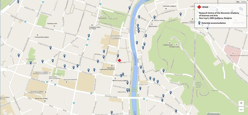
23rd meeting of the Working Group on Exonyms, ...............................................................................................................................25
Ljubljana MarCH 2020....................................................................................................................................................................................25
Sixth High Level Forum on United Nations Global Geospatial Information Management .................................................28
In Memoriam: Alan Rayburn (1932-2019).................................................................................................................................................29
UPCOMING EVENTS .............................................................................................................................................................................................30
UNGEGN Information Bulletin No. 57 • November 2019 • Page 3
MESSAGE FROM THE CHAIRPERSON

Chers Collègues,

L    es noms de lieux relèvent
     par nature de plusieurs
     disciplines.
appellation même dénote, d’une
part, leur appartenance au
                               Cette
                                                                             de stratégies de communication à combiner en leur faveur. Plusieurs
                                                                             contributions à la présente livraison de notre Bulletin d’information
                                                                             témoignent de différents dosages entre elles, que ce soit en termes de
                                                                             cible ou de contenu.

domaine de la linguistique,                                                  Mais ni le droit ni le raisonnement ni la communication ne peuvent
puisque ce sont des noms, d’autre                                            contrarier les tendances lourdes du langage. Au sein de chaque langue
part, leur objet proprement                                                  et de chaque culture, la force de l’analogie tend en permanence à mettre
géographique ou topographique,                                               ou à remettre en cohérence l’usage observé. Les deux objectifs de
puisque leur caractéristique est                                             l’usage et de la cohérence de la normalisation ne s’opposent donc pas
de désigner des lieux. Et ces noms                                           nécessairement. Tout le défi de notre travail est même de les rendre au
sont aussi en lien avec bien                                                 contraire compatibles, en sorte qu’ils se confortent réciproquement.
d’autres disciplines, comme la                                               Pour cela, dans chaque aire linguistique et culturelle, c’est de l’usage que
géopolitique, l’histoire ou le droit.                                        doivent être dégagées les règles qui fondent la cohérence du système de
La multiplicité de ces facettes                                              normalisation, afin que ce système soit suffisamment intuitif pour être
empêche toute approche trop                                                  adopté et appliqué par le public.
moniste à leur sujet et impose le pragmatisme.
                                                                             Cette tâche est à la fois nécessaire, modeste, passionnante est aussi
Aussi est-il naturel, et même nécessaire, que notre travail d’experts soit   inépuisable… Cette année, trois anniversaires nous rappellent tout
évalué à l’aune de sa réception par ses destinataires. Une bonne             particulièrement combien elle relève du long terme : les 60 ans de la
normalisation s’insère certes correctement dans un système cohérent,         décision des Nations unies de créer le GENUNG, bien sûr, mais aussi les
mais surtout, le critère fondamental de la linguistique est qu’elle se       100 ans du Permanent Committee on Geographical Names britannique
diffuse dans le public jusqu’à être employée couramment. Pour cela,          (PCGN) et les 50 ans de l’Arbeitsgemeinschaft für Kartographische
l’approche juridique de l’officialisation, que le GENUNG aurait tendance     Ortsnamenkunde autrichien (AKO). Je renouvelle ici à ces deux
à privilégier, n’a généralement que des effets limités, même au sein de      organismes nationaux l’expression de nos félicitations pour leurs travaux
l’administration ou auprès des autorités locales. Et l’approche              passés, de nos remerciements pour leur contribution aux travaux du
rationnelle d’une argumentation expliquant soigneusement les motifs          GENUNG et de nos meilleurs vœux pour leurs approfondissements
des positions prises par les experts dépasse rarement le cercle d’un         futurs !
public cultivé.

La communication est donc un complément nécessaire. Elle peut                Pierre Jaillard (France)
notamment s’appuyer sur l’actualité et se saisir de tout événement           Président du GENUNG
comprenant un enjeu toponymique pour expliquer celui-ci et montrer           Mél: pierre@jaillard.net
comment le prendre en compte. Aux différentes facettes des noms de
lieux correspondent autant de points de vue possibles sur eux et autant

                                           UNGEGN Information Bulletin No. 57 • November 2019 •             Page 4
MESSAGE FROM THE CHAIRPERSON

Dear Colleagues,

G        eographical names fall
         naturally within several
         disciplines. Their very being
places them, on the one hand,
                                                                             Bulletin reflect different approaches and implementations, both in terms
                                                                             of target and content.

                                                                             However, neither law, reasoning nor communication can go against
securely within the field of                                                 tendencies and developments of language. In each language and in each
linguistics, since they are names,                                           culture, the strength of analogy tends constantly to go in favour of
and, on the other, due to their                                              consistency of actual usage. The two goals of usage and of consistency
specifically      geographical      or                                       of standardization are therefore not necessarily opposed. The very
topographical denotation, squarely                                           challenge of our work is to make them compatible, so that they reinforce
within the subject of geography. In                                          and complement each other. In that order, in each linguistic and cultural
addition, geographical names are                                             area, it is from the usage that the system of standardization must be
also of significance to many other                                           extracted, so that this system is sufficiently intuitive in order that it can
disciplines, such as geopolitics,                                            be adopted and applied by people.
history or law. The multiplicity of
facets of geographical names                                                 This task is necessary, humble, exciting and also inexhaustible… This
prevent us from taking any too                                               year, three anniversaries remind us in particular of how long-term it is:
single-disciplinary approach to them but instead have a pragmatic            the 60th anniversary of the UN decision to create the UNGEGN, of
approach.                                                                    course, but also the 100 years of the British Permanent Committee on
                                                                             Geographical Names (PCGN) and the 50 years of the Austrian
It is therefore natural, and even necessary, to evaluate the work of us      Arbeitsgemeinschaft für Kartographische Ortsnamenkunde (AKO). I
experts in the light of its impact. Solid principles of standardization      renew here to these two national organizations the expression of our
certainly fit well in a coherent system. From here, the fundamental          congratulations for their past work, our thanks for their contribution to
linguistic criteria is that it spreads among people until gaining wide       the work of the UNGEGN and our best wishes for their future
acceptance and use. Unfortunately, the legal approach of formalization,      enhancements!
that UNGEGN favors, has often only limited effects, even within the
central administration or in local authorities. And the rational approach    Pierre Jaillard (France)
of an argumentation carefully explaining the motivation for                  Chair, UNGEGN
standardization taken by the experts rarely goes beyond the circle of        E-mail : pierre@jaillard.net
educated people.

Communication is therefore a necessary complement to
standardization. In particular, it can take advantage of the media and use
any event to use a toponymic issue, explain it and show the necessity of
standardization. The different facets of geographical names give reason
to as many possible points of view on geographical names and as many
communication strategies to be used in the favor of geographical names
standardization. Several contributions to this issue of our Information

                                           UNGEGN Information Bulletin No. 57 • November 2019 •             Page 5
MESSAGE FROM THE SECRETARIAT
Dear UNGEGN Experts,

Communication                                                                   Extending thanks to all our contributors to this issue and to Andreas
                                                                                Hadjiraftis of Cyprus for once again designing the front page.

A       n examination of the theme required that I have a clear
        definition of communication. The definition that most resonated
        given its seeming comprehensiveness was, “giving, receiving or
exchanging ideas, information, signals or messages through
appropriate media, enabling individuals or groups to persuade, to seek
                                                                                Preparation of UNGEGN’s Draft Strategic Plan and Programme
                                                                                of Work

                                                                                I wish to bring to your attention letter dated 15 October 2019 from the
information, to give information or to express emotions.1” I also note          UNSD on behalf of the UNGEGN Bureau inviting Member States to
that communication is important, it is often said that at the heart of a        participate in the development of the draft strategic plan and
successful organization the fundamental building block is effective             programme of work. Member States are asked to submit their national
communication. Communication promotes motivation, it is critical to             geographical names standardization issues and propose priority actions
altering behavior patterns, it is a source of information for decision          to be pursued by UNGEGN for the period 2021 to 2029. Please note if
making, it assists in controlling processes and it is a means of connecting     you have not received this letter, please send a note to blake1@un.org
people or places.                                                               and we will send you a copy.

Communication is not necessarily easily accomplished because it has             Your submission should be prepared taking into account the aims and
various forms, elements and challenges. The successful communicator             objectives of the new UNGEGN as stated in the Rules of Procedure
needs to consider the stakeholders to whom the message is being sent            (E/2018/L.25) and should be sent to the Secretariat at
and their culture, the channels and technologies to use, and the socio-         geoinfo_unsd@un.org before Friday, 13 December, 2019. The Bureau
economic and political environments. Today the average man is                   looks forward to having your input and support throughout all phases
bombarded with information emanating from main stream media -                   for the development of the draft strategic plan and programme of work
                                                                                which is to be submitted to the Group of Experts at its second session
television networks, the newspapers, social media – Twitter, Facebook,
                                                                                in May 2021.
LinkedIn, Medium, online technical magazines, blogs, e-mail blasts,
voice mail, bill board signs and videos, and formal engagements such as
                                                                                General Remarks
meetings, conferences, briefings, workshops etc. Which is most
effective? This task therefore requires special skills sets which a linguist,   Member States and national institutions responsible for geographical
geographer, cartographer or toponymist may not necessarily have. This           names are reminded to submit their information for the UNGEGN
issue therefore shares the strategies that have been used by eight              World Geographical Names Database. We also wish to inform our
national geographical names authorities across the world - Argentina,           global experts and persons wishing to learn more about toponymy that
Australia, Burkina Faso, Canada, Cyprus, Czech Republic, New Zealand            they can pursue the online BSc level, web course at:
and the United Kingdom to implement the use of standardized                     https://bit.ly/31FrL66 and access the recently released Toponymy
geographical names. I found of great interest, the reference to                 Training Manual at https://bit.ly/2ZxYatc.
augmented and virtual reality as an emerging area for communicating
place names submitted by Rafe Benli from Geographic Names Victoria,             Your comments on this issue and contribution to Bulletin number 58, to
Australia. I had hoped that he would have expanded to share how he              be circulated in May 2020 under the theme “Issues & experiences in
                                                                                the standardization of geographical names”, are welcomed. Please
envisions this technology impacting the communication of place names.
                                                                                remember to repost and circulate the bulletin among your colleagues
I think a communication strategy that would be most effective is,               and hoping you will find this issue enriching and interesting.
identify where your stakeholders and users are reading and interacting
and meet them there, directly engage them and share your message. I
encourage you to read the articles and discover how geographical
                                                                                Cecille Blake
names are being communicated to inform, educate and persuade                    UNGEGN Secretariat
stakeholders on the importance and use of standardized geographical             E-Mail: blake1@un.org
names.

1https://www.communicationtheory.org/definitions-of-
communication/, accessed on 11 November 2019.

                                             UNGEGN Information Bulletin No. 57 • November 2019 •           Page 6
SPECIAL FEATURE

       COMMUNICATION STRATEGIES FOR ENCOURAGING THE
    IMPLEMENTATION OF STANDARDIZED GEOGRAPHICAL NAMES

ARGENTINA
Towards the Standardization of Geographical Names in Argentina
Institutional Framework                                                         UNGEGN; International Cartographic Association (ICA); International
                                                                                Council of Onomastic Sciences (ICOS); IGN; Argentine Center of

T      hroughout its evolution as a Military Geographical Institute (IGM)       Cartography (CAC -Member of ICA-); Argentine Society of Geographic
       and, since 2009, as a National Geographic Institute (IGN),               Studies GAEA; Spatial Data Infrastructure of the Argentine Republic
       initiatives of different scope were developed to normalize the           (IDERA); Ministry of Foreign Affairs and Cult of the Nation; and Ministry
geographical names of the national territory according to the mission           of Defense of the Nation.
assigned by Law 22.963 “Law of the Charter” and its amendments. So
far, standardization work was carried out without a permanent                   Their participation was mainly aimed at the following strategic
regulatory framework. However, the exceptional global changes in                objectives:
technology and paradigms, promoted the need to set normalization                     -    to position the IGN as a national authority in the
processes in all steps of the institution´s cartographic production. This                 standardization of geographical names and stimulate the
is also the case of geographical names management, which makes                            participation and responsibility of the Argentine political
interoperability of geospatial information possible.                                      jurisdictions and other agencies producers of geospatial
                                                                                          information in the national standardization of geographical
To these technological changes, new trends are added: the revaluation                     names,
of geographical names as a reserve of cultural heritage, Open                        -    to disseminate the importance of taking care of the quality of
Government policies, and the collaborative model. As part of a new                        geographical names from its two fields of analysis: as
institutional approach, the IGN developed its 2015-2020 Management                        georeferenced data and as intangible cultural heritage of the
Plan (1), a document with objectives and goals explicitly incorporated                    Nation,
related to the standardization of geographical names. In 2016, Law                   -    to raise awareness among national jurisdictions and the
27.275 “Law on the Right to Access to Public Information” was enacted,                    various public administration agencies about the importance
which includes the country in the international trend of Open Data.                       of national standardization of geographical names as a basis
                                                                                          for the harmonization of geospatial information in IDERA,
In order to respond to the demands of these new contexts, the IGN                    -    to highlight the need and benefits of its national
recently began the development of a Manual for the National                               standardization, as a contribution to international
Standardization of Geographical Names. Under the responsibility of the                    standardization and to the achievement of the Sustainable
Directorate of Geography, it is its objective to establish a unified registry             Development Goals and other United Nations projects and
of the writing of the geographical names of the national scope as part                    programs.
of its cultural heritage and as a georeferenced data for the Institutional
Geographic Database (IGDB). It is also proposed to contribute to the            Institutional Training
objective of the United Nations of having National Gazetteers as a basic
and official source of a Global Spatial Data Infrastructure (GSDI).             Internal Institutional Training Days (2019 and 2017) were held with the
                                                                                following strategic objectives:
Communication actions                                                                -     to train all the actors involved in the processes of institutional
                                                                                           production and dissemination in the general concepts of
Since its passage to the national scope, the IGN develops awareness,                       standardization in geographical names,
dissemination and training actions in Geographical Names through the                 -     to disseminate the projects and institutional actions carried
following strategies:                                                                      out in relation to the national standardization of geographical
•    Participation in national and international conferences and                           names,
     congresses organized by the following organizations and
     institutions:

                                             UNGEGN Information Bulletin No. 57 • November 2019 •              Page 7
-   to highlight the benefits of having a unique written form for   •   Online information
        each of the geographic objects of the IGDB, in order to             -    Incorporation of Information about the UNGEGN on the IGN
        harmonize its inclusion in all the institutional products and            Website:
        activities.
                                                                                 o    UNGEGN general information update (5)
                                                                                 o    Standardized country names, according to the Group on
                                                                                      Country Names Report, updated to 2019, as a source of
                                                                                      internal and external consultation: the education sector,
                                                                                      proofreaders, institutions, editors and the general public
                                                                                      (6).

                                                                            -    Information about Argentina on the UNGEGN website

                                                                                 o    Inclusion of the IGN as a National Authority
                                                                                 o    Inclusion of sound files with the name pronunciation of
                                                                                      the cities of more than 100,000 inhabitants (INDEC 2010)
                                                                                      (7).
•   Periodical institutional publications
    -    Geographic Atlas of the Argentine Republic (2): the chapter    Conclusions
         THE CARTOGRAPHY OF TODAY, dedicates three titles to the
         development of the toponymic theme: Toponymy:                  Towards the future, it is planned to finalize the redaction and
         Geographical Names; Toponymy Normalization History; and        publication of the Manual for the National Standardization of
         indigenous toponyms in the Official Cartography.               Geographical Names for the IGDB; and complete the Concise Gazetteer
                                                                        (scale 1: 5,000,000) of Geographical Names of the Argentine Republic
                                                                        and its link to the BDGI. Likewise, it is planned to continue with the
                                                                        communication strategies mentioned above, as well as evaluate new
                                                                        tactics aimed at expanding the application of the standardization
                                                                        process at the institutional and national level.

                                                                        References for online
                                                                        (1) http://static.ign.gob.ar/plan_de_gestion/Plan_de_Gestion_del_I
                                                                                 GN_2015-2020.pdf
                                                                        (2) http://www.ign.gob.ar/AreaServicios/Publicaciones/Atlas2015
                                                                        (3) http://www.ign.gob.ar/NuestrasActividades/Geografia/DatosArg
                                                                             entina/ToponimiaMalvinas
                                                                        (4) http://www.ign.gob.ar/AreaServicios/Publicaciones/RevistaOjoC
    -   Institutional Magazine “El Ojo del Cóndor” (4): disseminates         ondor
        the IGN activities, and dedicates a dossier to the different    (5) http://www.ign.gob.ar/AreaInstitucional/UNGEGN
        regions of the country. Most of the issues include articles     (6) http://www.ign.gob.ar/NuestrasActividades/Geografia/DatosArg
        related to local toponymy, as well as events, congresses and         entina/PaisesMundo
        projects associated with geographical names.                    (7) http://unstats.un.org/unsd/geoinfo/geonames/

                                                                        Adriana Vescovo / María Dolores Puente
                                                                        Dirección Nacional de Servicios Geográficos
                                                                        Instituto Geográfico Nacional (Ign)
                                                                        República Argentina
                                                                        E-mail: avescovo@ign.gob.ar / dpuente@ign.gob.ar

                                        UNGEGN Information Bulletin No. 57 • November 2019 •        Page 8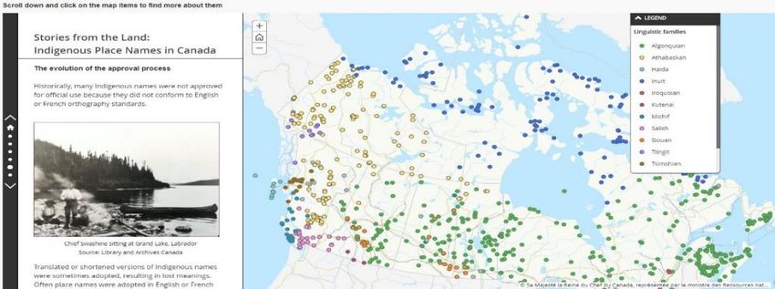
AUSTRALIA

T     he United Nations' Group of Experts on Geographic Names
      (UNGEGN) acknowledge the importance of geographic names,
      noting they are vital keys for accessing information in our
globalised digital world.

We know there are many benefits of considered place naming,
including recognition and identification of history, culture and
connection to country and accurate description of landscape. Through
a standardised approach to place naming there are further benefits,
including:

•    efficiencies for emergency services response, natural disaster
     relief, communications including postal and news services, and
     trade and commerce
•    easier collection of data, including population censuses and
     statistics
•    accurate data collection for property rights and cadastre
                                                                             Here are the essential questions we must be able to answer:
In turn, these benefits lend advantage and efficiencies to urban and
regional planning, environmental management, map and atlas                   1.   What is place naming?
production, navigation and tourism.                                          2.   Why is it important?
                                                                             3.   How is place naming managed in your member country?
As you can see, appropriate naming of place allows clarity and precision,
meaning citizens can go about their daily lives certain of the names of      For questions 1 and 2, information is available from UNGEGN, for
the places to which they are going. Uniqueness and accuracy also             example the goals of UNGEGN: Standardisation, Dissemination and
reduces the likelihood of confusion for emergency services and assists       Romanization, available on the homepage of their website.
with service delivery by other agencies and companies.
                                                                             Once your foundations are solid, you are ready to communicate! From
Perhaps more important but less tangible, appropriate naming ensures         here there are four principles which are deliberately simple:
a strong link to place and connects cultural identify to the past, present
and future.                                                                  1.   Avoid jargon
                                                                             2.   Tell a story
Across Australia and New Zealand, jurisdictional legislation provides        3.   Know your audience
guidance for how places should be named, for example, Queensland’s           4.   Stay well-informed of technology trends.
Place Names Act 1994 or the New Zealand Geographic Board (Ngā Pou
Taunaha o Aotearoa) Act 2008. To ensure broad alignment, we also             By example, Eleanor Lucas founded E Lucas & Co - a humble textile
have the Permanent Committee on Place Names.                                 company - in Ballarat, Australia in 1888. The Lucas Factory grew and, in
                                                                             1917, 500 employees planted more than a thousand trees in
In the Victorian jurisdiction of Australia, the Geographic Place Names       commemoration of Ballarat’s enlisted men of World War One. There
Act 1998, includes Naming rules 2 which set out the process and              were another few thousand planted in 1919, and the result is the
requirements for consultation in selecting, assigning or amending a          Ballarat Avenue of Honour, which stretches 22 kilometres - perhaps the
name of a place, including Aboriginal or Torres Strait Islander names. It    longest avenue of honour in the world.
also specifies criteria for assessing cultural heritage or other
significance.                                                                In 2011, the City of Ballarat looked to name a new suburb. They
                                                                             consulted with the local community and the name Lucas was chosen for
Only with such well-established governance can we more easily                the suburb, with streets being assigned Veteran’s names. The suburb
articulate the what, why and how of place naming, which is essential to      and road names were registered by the Victorian Government as they
effective communications strategies for encouraging the                      complied with the Naming rules.
implementation of standardised geographical names.
                                                                             Lucas provides an excellent example of story-telling and highlights to
                                                                             citizens the importance and connection of a place’s name and history.

2
  Naming rules for places in Victoria – Statutory requirements for naming
roads, features and localities 2016. (GEGN.2/2019/CRP.126)

                                              UNGEGN Information Bulletin No. 57 • November 2019 •        Page 9
While certain mediums lend themselves more to storytelling - for             National naming authorities need to ensure that when talking about
example print or radio - social and digital media also has a role to play.   place names, they can do so in everyday language that is
For example, the Australian Broadcasting Corporation recently                understandable to a wide range of government, community and
highlighted the importance of Indigenous languages via ‘This place’, a       business audiences. It’s important it is engaging for audiences without
website on which Indigenous communities share the meaning of the             having to become immersed in the details of the subject matter, and
place names of their country.                                                this should apply to government briefings and presentations as much as
                                                                             it does social posts and brochures.

                                                                             Having said that, it is important to know your audience, and in some
                                                                             circumstances, a certain amount of practical knowledge may be
                                                                             appropriate.

                                                                             In Victoria, communications and engagement has been successfully
                                                                             undertaken via face to face training sessions, workshops and road
                                                                             shows, as well as newsletters being sent out via email. Throughout 2019
                                                                             we have celebrated the United Nations Year of Indigenous Languages,
                                                                             and workshops have been held across Victoria enabling naming
                                                                             authorities to hear first-hand from Aboriginal Traditional Owners. As a
                                                                             direct result, Geographic Names Victoria has seen an increase in
                                                                             interest of Aboriginal language and assignment of Aboriginal place
                                                                             names. While they have been awarded the Good Design Award of
                                                                             Australia for Social Impact, the greatest benefit of the workshops is that
                                                                             they are a continuation of the journey with Aboriginal Traditional
                                                                             Owners.

                                                                             Finally, an emerging area for place naming is augmented and virtual
                                                                             reality. It will be very exciting to see how the importance of place,
                                                                             Indigenous names, benefits for emergency services and the protection
Another Victorian example using social media, is Woowookarung                of cultural heritage can be communicated through tech and new media.
Regional Park, a five minute video which showcases the importance of         It is important that naming bodies provide consistent advice on naming
indigenous names and language.                                               practices and remove terminology jargon, using simple language which
                                                                             is easily understood to ensure standardised naming. I encourage
                                                                             naming authorities to ensure that communication is considered in
                                                                             strategies and work plans. By understanding what is being delivered at
                                                                             international, national and local levels, we can make sure we better
                                                                             communicate the standardisation of place names to citizens.

                                                                             Rafe Benli
                                                                             Project Manager
                                                                             Geographic Names Victoria
                                                                             Australia
                                                                             Email: rafe.benli@delwp.vic.gov.au

                                           UNGEGN Information Bulletin No. 57 • November 2019 •           Page 10
CANADA
Raising Awareness of Standardized Geographical Names in Canada
T he use of standardized geographical names has been at the
forefront of the activities of the Geographical Names Board of
Canada since its inception over 120 years ago. During the 1880’s,
Canadian geologists and surveyors were using topographic maps that
were often inconsistent in the spelling and application of geographical
industry, increasing awareness of the work of the board to ensure that
Canada’s national names database is authoritative and standardized.
In 2018, the GNBC designated Geographical Names Day to
communicate the importance of standardized official geographical
names. The geologists submitted a proposal to the federal government names. The inaugural day was communicated extensively through
to form a single authority responsible for the standardization of social media channels and celebrated through official events.
geographical names in Canada. The result of this request was an Order Geographical Names Day will be celebrated annually in Canada each
in Council establishing the Geographic Board of Canada (now called the November during Geography Awareness Week to promote
Geographical Names Board of Canada, or GNBC) in 1897 as the body standardized official names and to publicize the activities of the GNBC.
responsible for
standardizing official place
names.
The activities of the GNBC
are guided by a five-year
strategic plan determined
through discussion and
consensus by Canada’s
federal, provincial and
territorial naming
authorities. Raising
awareness of standardized
geographical names is a
significant priority of the
strategic plan. The
Awareness Working Group of the GNBC is tasked with developing a
national strategy to raise the awareness of the importance of The GNBC also promotes the use of standardized geographical names
standardized, authoritative geographical names with the public and through open source downloadable files available to the public from the
decision-makers. The goal of the working group is to have Canadians Canadian Geographical Names Database (CGNDB). The CGNDB is
recognize and appreciate the cultural, historical and practical value of Canada’s national repository for authoritative place names and is
geographical names as an integral part of their daily lives and shared comprised of data submitted through the federal, provincial and
cultural heritage, along with the key role played by the GNBC in territorial naming authorities. The use of standardized core fields in the
standardizing official names. Their work has resulted in several key national database is essential to storing, maintaining and disseminating
communications initiatives. official Canadian geographical names.
To help raise awareness of the board, the GNBC launched two Careful management and standardization of geographical names in
interactive maps to the public in 2018-2019: Canada remains as important now as in 1897. In Canada,
communications initiatives are part of the national naming authority’s
• Canada’s Commemorative Map, an interactive, online strategy to raise awareness of the importance of standardized
presentation of text, images and videos to explore a selection of geographical names. Standardization ensures that the data is easily
the places and features that are named to commemorate Canada’s accessibly, readable, and interoperable with other datasets.
participation in wars and conflicts.
• Stories from the Land: Indigenous Place Names in Canada, an
interactive map showing a selection of the thousands of official Kristina Kwiatkowski and Steve Westley
names in Canada that have origins in over 65 Indigenous Geographical Names Board of Canada Secretariat
languages, highlighting the diversity, history and geographical Natural Resources Canada
breadth of Indigenous place names across Canada. Canada
Email: kristina.kwiatkowski@canada.ca
Both of these maps were released through special events with media steve.westley@canada.ca
coverage and announcements through social media channels. These
maps have raised the profile of the GNBC with the public, academia and
UNGEGN Information Bulletin No. 57 • November 2019 • Page 11CANADA
Sensibilisation à l’uniformisation des toponymes au Canada
L ’utilisation de toponymes uniformisés est au cœur des activités de
la Commission de toponymie du Canada depuis sa création il y a
plus de 120 ans. Au cours des années 1880, les géologues et
arpenteurs canadiens utilisaient des cartes topographiques dont
l’orthographe et l’application des toponymes étaient souvent
données des noms nationaux du Canada fasse autorité et soit
uniformisée.
En 2018, la CTC a instauré la Journée des noms géographiques pour
communiquer l’importance des toponymes officiels uniformisés. La
incohérentes. Les géologues ont soumis au gouvernement fédéral une journée inaugurale a été largement diffusée sur les médias sociaux et
proposition visant à former une autorité unique responsable de célébrée lors d’événements officiels. La Journée des noms
l’uniformisation des toponymes au Canada. À la suite de cette géographiques sera célébrée chaque année au Canada en novembre
demande, un décret a établi la Commission de géographie du Canada pendant la Semaine de sensibilisation à la géographie afin de
(maintenant appelée la Commission de toponymie du Canada, ou CTC) promouvoir les noms officiels uniformisés et de faire connaître les
en 1897 en tant qu’organisme
responsable de l’uniformisation
des toponymes officiels.
Les activités de la CTC sont guidées
par un plan stratégique
quinquennal établi à la suite de
discussions et d’un consensus
entre les autorités fédérales,
provinciales et territoriales du
Canada. La sensibilisation à
l’uniformisation des toponymes
est une priorité importante du
plan stratégique. Le Groupe de
travail sur la sensibilisation de la CTC est chargé d’élaborer une stratégie activités de la CTC.
nationale pour sensibiliser le public et les décideurs à l’importance de
disposer de toponymes uniformisés et faisant autorité. L’objectif du
groupe de travail est de faire en sorte que les Canadiens reconnaissent La CTC fait également la promotion de l’utilisation de toponymes
et apprécient la valeur culturelle, historique et pratique des toponymes uniformisés au moyen de fichiers téléchargeables à source ouverte
comme partie intégrante de leur vie quotidienne et de leur patrimoine accessibles au public à partir de la Base de données toponymiques du
culturel commun, ainsi que de mettre en valeur le rôle clé joué par la Canada (BDTC). La BDTC est le registre national des noms de lieux
CTC dans l’uniformisation des noms officiels. Leur travail a donné lieu à faisant autorité au Canada et comprend des données soumises par
plusieurs initiatives clés en matière de communication. l’entremise des autorités de dénomination fédérales, provinciales et
territoriales. L’utilisation de champs uniformisés dans la base de
Pour mieux faire connaître la Commission, celle-ci a lancé deux cartes données nationale est essentielle au stockage, au maintien et à la
interactives à l’intention du public en 2018-2019 : diffusion des toponymes officiels du Canada.
• La carte commémorative du Canada, une présentation La gestion prudente et l’uniformisation des toponymes au Canada
interactive en ligne de textes, d’images et de vidéos pour demeurent aussi importantes aujourd’hui qu’en 1897. Au Canada, les
explorer une sélection de lieux et d’éléments qui initiatives de communication font partie de la stratégie de l’autorité
commémorent la participation du Canada aux guerres et aux toponymique nationale visant à sensibiliser la population à
conflits. l’importance de l’uniformisation des toponymes. L’uniformisation
• Récits du territoire : Noms de lieux autochtones au Canada, garantit que les données sont facilement accessibles, lisibles et
une carte interactive montrant une sélection des milliers de interopérables avec d’autres ensembles de données.
noms officiels au Canada qui tirent leurs origines de plus de
65 langues autochtones, soulignant la diversité, l’histoire et
l’étendue géographique des noms de lieux autochtones au Kristina Kwiatkowski and Steve Westley
Canada. Geographical Names Board of Canada Secretariat
Natural Resources Canada
Ces deux cartes ont été lancées à l’occasion d’événements spéciaux qui Canada
ont fait l’objet d’une couverture médiatique et d’annonces sur les Email: kristina.kwiatkowski@canada.ca
médias sociaux. Ces cartes ont accru la visibilité de la CTC auprès du steve.westley@canada.ca
public, du milieu universitaire et de l’industrie, ce qui a permis de mieux
faire connaître le travail de la Commission de sorte que la base de
UNGEGN Information Bulletin No. 57 • November 2019 • Page 12CYPRUS
Introduction • Law 43(I)/2010 – Creation of Spatial Data Infrastructure (INSPIRE).
Enacted on 14.5.2010.
T he Cyprus Permanent Committee for the Standardization of
Geographical Names (CPCSGN) was initially created in 1967. It
was officially established by the decision of the Council of
Ministers no.15.769 of 21.4.1979 and constitutes the only competent
National Authority for the Standardization of Geographical Names in
According to law 43(I)/2010, the Government of Cyprus is obliged to
create a Spatial Data Infrastructure (SDI), along with a mechanism to
search, view, download and direct access spatial data of government
and semi-government organizations in Cyprus, in accordance to
Cyprus. According to law N.66(I)/98, the Committee operates under the Directive 2007/2/EC (INSPIRE) of the European Union. A total of 34
Minister of Education and Culture. The CPCSGN, based on legislation, spatial themes are included, and each data theme is sub-divided into
actively promotes the implementation of standardized geographical several other sub-themes, including metadata, datasets and e-services.
names in Cyprus. A series of tools and actions enable the Committee to Geographical names constitute a significant part of the SDI and play a
adopt a strategy for encouraging the implementation of standardized very important role.
geographical names such as: legislation, creation, maintenance, and
distribution of gazetteers and spatial databases, distribution of several National Gazetteer of Geographical Names of Cyprus
editions on geographical names, extensive use of its website and web
applications, publicity, engagement of experts from several fields, such All geographical names and toponyms of Cyprus are included in a
as: linguists, cartographers, philologists, archaeologists, IT experts, and “Complete Gazetteer”. The Gazetteer is currently available on
lawyers. CPCSGN’s website at:
http://www.geonoma.gov.cy/myfiles/ekdoseis/cygazetteer/index.htm
l.
Gazetteer of Sea Geographical Names
An edition was prepared by the CPCSGN entitled: “Gazetteer of Sea
Geographical Names of Cyprus”. This Gazetteer is available at:
http://www.geonoma.gov.cy/myfiles/ekdoseis/thalassia-
toponymia/index.html
Odonyms
Odonyms in Cyprus are given and maintained by the Municipal and
Community Councils. These odonyms, are under the approval of the
respective District Officers, which operate under the Ministry of
Interior. All official street names are communicated to the CPCSGN, for
checking and correction, in order to achieve uniformity all over the
island.
A complete catalogue of odonyms is maintained by the Department of
Figure 1: Strategy for encouraging the standardization
Postal Services at: https://www.cypruspost.post/el/ekdoseis
of geographical names in Cyprus
Geographical Names in Spatial Data Infrastructure (SDI)
Legislation
All geographical names and toponyms are included in the geoportal of
The following laws and regulations concern the geographical names of Cyprus at: www.geoportal.gov.cy. Geographical names and other geo-
the Republic of Cyprus, and the operation of the Permanent Committee spatial information are accessible on-line for searching, viewing,
for the Standardization of Geographical Names: transformation, downloading, printing, and direct accessing via GIS.
• Law N. 66(I)/1998 – Procedure for standardizing the geographical CPCSGN Editions and Current Activities
names of the Republic of Cyprus. Enacted on 17.7.1998.
• Κ.Δ.Π. 443/2001 – Regulations on the procedure for standardizing The Committee has issued various independent publications that help
the geographical names of the Republic of Cyprus. Enacted on in understanding the issues which relate to geographical names,
30.11.2001. contribute to the solution of problems arising, and also further promote
• Law Ν.71(Ι)/2013 – Amendment to law on the Procedure for the standardization of geographical names:
standardizing the geographical names of the Republic of Cyprus. A Booklet/Guide for the Standardization of Names was compiled and
Enacted on 19.7.2013. published in December 2007. This Guide is in Greek language and
includes a large number of items to cover all the sectors involved with
UNGEGN Information Bulletin No. 57 • November 2019 • Page 13geographical names and is suitable especially for local use and needs. the book marker include brief information regarding the tasks
The Committee continues to distribute this booklet to academic undertaken by the Committee and also includes the transliteration rules
institutions, schools, government and semi-government departments, followed. The poster is also available for downloading at:
cultural centers, and individuals interested in the topic. This booklet is http://www.geonoma.gov.cy/myfiles/archeia/diafotisi/2015_poster_o
also available at: utline.pdf
http://www.geonoma.gov.cy/myfiles/ekdoseis/odigos-
typopoiisis/index.html
A very helpful tool was developed for the automatic transliteration of
A Promotional Brochure on the Standardization of Geographical Names, geographical names from greek to roman alphabet, based on ELOT 743,
was prepared in both Greek and English, and it was widely distributed which is available on-line at:
to all government departments, organizations, academic institutions http://www.geonoma.gov.cy/index.php/typopoiisi/metagrafi-ellnikou-
and other interested organizations and citizens. It continues to be alfavitou
distributed when needed. This brochure is also available at:
https://unstats.un.org/unsd/ungegn/pubs/documents/UNGEGN%20Br
ochure_Greek_Cyprus.pdf
A brief leaflet on the standardization of geographical names was
prepared by the Committee and it was distributed to schools. This
leaflet is also available at:
http://www.geonoma.gov.cy/myfiles/archeia/diafotisi/geographical_n
ames_standardization.pdf
A list of names of countries and capitals, in Greek and English, was
submitted during the 10th UN Conference and the 27th Session of
UNGEGN, and was also distributed to many government departments,
ministries, academic institutions, schools, and other interested bodies.
It is also available on CPCSGN’s website:
http://www.geonoma.gov.cy/myfiles/ekdoseis/chores-
protevouses/index.html
Poster and Book Marker on the Standardization and
Figure. 3: Tool for automatic transliteration from greek to roman
Transliteration of Geographical Names alphabet
CPCSGN prepared a poster regarding the standardization and
transliteration of geographical names. This poster was distributed to all
high schools. The Committee also published a book marker which was
distributed to all schools and government departments. The poster and The tool has the capability of transliterating single names or a list of
names from greek to roman alphabet. The tool is extensively used by a
wide variety of users, including government departments, academic
institutions, private organizations, and citizens.
Conclusion
The CPCSGN, realizing the benefits, strongly supports the efforts
undertaken by the UN for the standardization of geographical names,
and aims to fully comply and implement the UN and UNGEGN
Conferences resolutions for the standardization of geographical names.
The Committee maintains very close relationship with other relative
bodies, government departments and institutions, and continuously
enhances its strategy for encouraging the standardization of
geographical names.
Andreas Hadjiraftis
President of Permanent Committee for the Standardization
of Geographical Names of Cyprus
Ag. Chief Lands Officer,
Cartography/Geodesy/Hydrography/Photogrammetry,
Figure 2: Poster for the standardization and transliteration of Department of Lands and Surveys, Ministry of Interior
geographical names Cyprus
Email: ahadjiraftis@dls.moi.gov.cy
UNGEGN Information Bulletin No. 57 • November 2019 • Page 14CZECH REPUBLIC
Communication procedures for processing geographical names in the information system
Geonames and the information system Jména světa
T he communication strategy includes objectives and methods of
communication in the office with regard to its external
environment, that is, communication with other central
authorities and ministries, and with self-government, experts, citizens
and users. Each organization must clarify what it wants to convey to the
hydrography (physical waters, net), Registry of Territorial Identification,
Addresses and Real Estates (RÚIAN), cadastral maps.
Depending on the processes, the data is processed as follows:
public and other government institutions, and to whom
specifically this communication will be addressed. It is of
course necessary to work out a way to communicate.
The office communicates with other officials, experts, users
and data creators. The communication strategy is based on
experiences from previous years and its changes are minimal
and more formal (e. g. an e-mail instead of a letter, electronic
submission instead of an official letter, electronic signature
instead of a stamp). Some great advantages of digital
communication are map and image attachments, a possibility
to send grid and vector data and exports from databases.
It is necessary to keep data, including geographical names, in
the current used and usable states.
For this reason the Secretariat of the Czech Commission on The result of our communication and field survey is the storage of data
Geographical Names communicates with these entities: in Geonames, land surveying information system. The data are used for
a state map series in various scales (from 1 :1 000 000 up to 1 : 1 000
1. General public - citizens m), but also digital, especially vector data in the form of files. Maps, file
2. Expert public – resort staff, experts from other offices, institutions, data and web services (WMS, WFS…) are provided to the public and
self-government workers, educated users and specialized high experts – partly as open data and partly for payment. Data is published
schools and universities on Geoportál https://geoportal.cuzk.cz/geoprohlizec/. The reporting of
errors is a part of Geoportál, which enables its users to send feedback.
Entity Type of communication The reported error is always solved and the user is informed of the
General public - citizens reporting changes in Geoportal, result. This provides feedback for the data. We gradually adjust the data
email, letter, phone call according to the users' demands; we especially expand the number of
Expert resort staff a) reporting changes in Geoportal, named objects. We collect these names, save them and update them.
public experts from other email, letter, phone call
offices b) appeal for data verification For names outside the Czech Republic we have an information system
experts from other c) data exchange and sharing (IS) Jména světa (IS Names of the Word). In this system, we collect and
institutions agreements maintain up-to-date lists of state names - Names of the States and Their
self-government d) direct participation of Territorial Parts, Index of Czech Exonyms, Czech Names of Seas and
workers representatives of particular International Territories. We publish these names at
educated users ministries and university experts http://jmenasveta.cuzk.cz/ and also in publications from the series
specialized schools and representatives of specialized UNO Gazetteers of Geographical Names-CZ. We communicate with
associations in meetings of the experts, especially geographers but we also collect data from official
Czech Commission on Internet websites, often from different language versions of Wikipedia.
Geographical Names - as It is possible to report an error in this application as well. Collected
members or invited experts names are used by authors of atlases and tourist maps, journalists and
other publishers but also translators, e. g. to the Council of the
The most important are self-governments, confirming the validity and European Union.
use of names on their territory for towns and municipalities.
Cooperation with municipalities is embodied in the Law on Surveying. Irena Švehlová
Data from other sources of the surveying department, concerning Secretary Commission on Geographical Names
changes in terrain, are also used for updating: The Fundamental Base of Czech Republic
Geographic Data of the Czech Republic (ZABAGED®) planimetric E-mail: irena.svehlova@cuzk.cz
components and altimetry and elevation, transport networks,
UNGEGN Information Bulletin No. 57 • November 2019 • Page 15NEW ZEALAND
Introduction non-official place name being used. Instead it liaises with offenders to
remedy non-compliance and offer assistance.
S
tandardized place names are key to locating people and places.
They contribute to efficient communication and government Communicating with the right people
administration, are important landmarks of our history, culture
and identity, and enable the linking of data for a wide range of As soon as possible after a place name is made official the NZGB sends
public and private use. Communicating with and encouraging people to out a general email advisory, with the official notice attached, to all
understand the importance of using New Zealand’s standardized official interested parties pointing out the requirement to use the official place
place names is a challenge that the New Zealand Geographic Board Ngā name and why. Avoiding information overload, making our
Pou Taunaha o Aotearoa (NZGB) regularly faces. communications easily understood, and building relationships so that
we target the right people with information about using official place
names is an ongoing challenge.
To build its profile and promote and encourage the communities’
understanding and implementation of official place names, the NZGB
takes advantage of opportunities to speak to agencies and
organisations, attend conferences and events, and participate in media
interviews and podcasts. The NZGB also has a social media presence on
Land Information New Zealand’s Facebook page. However, a primary
issue for the NZGB is that it has limited control on open-source services
beyond our shores such as Google Maps, which doesn’t use official data
and so may show incorrect place names.
Communicating the relevance
The NZGB aims to be proactive in encouraging people to use official
place names in everyday life so that everyone knows the name of a
place or feature. A primary strategy is to communicate the relevance of
using our official place names, so that people can identify where they
are as they go about their everyday business, and most importantly, in
emergency responses people can effectively communicate information
about location that is unique and unambiguous. Promoting the use of
New Zealand’s official place names also facilitates communication and
cooperation between local, national, and international organisations,
and is an opportunity for people to understand the stories behind our
Compliance places.
The requirement to use official place names in all official documents Raising awareness of New Zealand’s place name data
including on road signs, official maps and charts, and in scientific
publications and information for tourists is captured in section 32 of the A key to encouraging people to use New Zealand’s official place names
New Zealand Geographic Board (Ngā Pou Taunaha o Aotearoa) Act 2008 is communicating that they are available and easily accessible in the
(NZGB Act 2008). There is a proviso allowing for non-official place NZGB’s online Gazetteer, which holds trusted and authoritative
names to be used provided it is stated that it is not the official name. information, and is the reliable single point of truth for our place names.
Section 33 of the NZGB Act 2008 sets a heavy penalty for non- The NZGB actively promotes use of its Gazetteer in everyday
compliance and provides for the NZGB to apply to the High Court for an correspondence with government agencies and people making
injunction to prevent non-official place names being used in official enquiries. When advising various agencies of place names being
documents. standardized and made official, a strategy is to raise awareness that the
datasets are freely available for downloading and open use either as a
While aiming to be proactive so that people are aware of their CSV file or through Land Information New Zealand’s Data Service.
obligations to use official place names, the NZGB is mindful of cost.
Therefore, updating road signs, promotional material, maps, databases,
etc., can be done over time and in the course of usual maintenance. To
date the NZGB has not applied for a High Court injunction to prevent a
UNGEGN Information Bulletin No. 57 • November 2019 • Page 16Vous pouvez aussi lire