CARPE Inception Workshop - WRI CARPE Data and Mapping Forest Concession Monitoring B. Mertens
←
→
Transcription du contenu de la page
Si votre navigateur ne rend pas la page correctement, lisez s'il vous plaît le contenu de la page ci-dessous
CARPE Inception Workshop
       Yaoundé, 7-9 février 2007

     CARPE Data and Mapping
    Forest Concession Monitoring

             B. Mertens
                WRI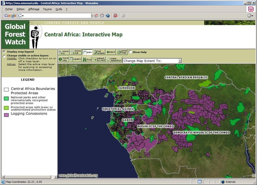
Suivi de l’exploitation forestière
Contribution WRI
Objectifs et activités en Afrique Centrale
Résultats obtenus ou attendus
Quelles sont les produits ou outils élaborés?
Quels sont les informations disponibles?
Contraintes d’accès aux données de base
Perspectives CARPE II
Accès aux données / outils
Planification CARPE II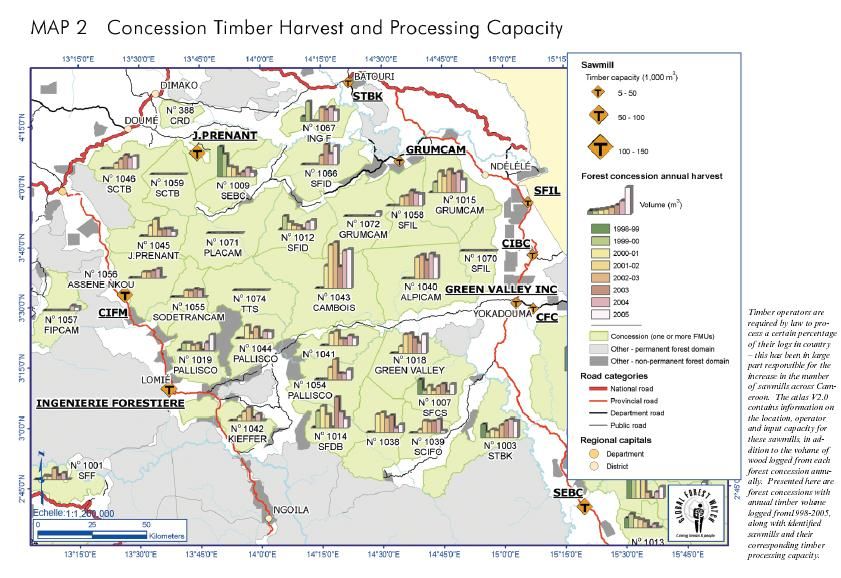
Objectif du projet
Les gouvernements, ONGs, collectivités locales, institutions de recherche,
secteur privé, etc. de cinq pays de la sous région disposent d’informations
à jour, complètes et précises quant à l’exploitation et la gestion des forêts.
Pour que ces informations favorisent la mise en
oeuvre de pratiques de gestion forestière durable,
elles seront :
Associées au renforcement des capacités
techniques et de prises de décision (formation,
sensibilisation, outils conviviaux, etc)
Rendues publiques pour inciter les secteurs
privés et publics à être redevables de leurs
actes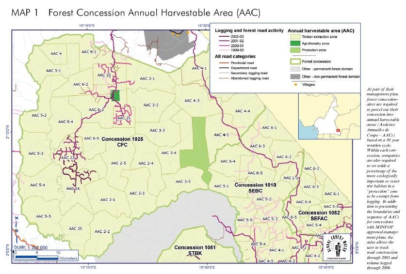
Objectif spécifique
Appui au développement et la mise en œuvre d’outils de suivi et
surveillance de l’exploitation forestière dans le bassin du Congo
Cartographie des titres d’exploitation et infrastructures
Expertise SIG, télédétection, outils GPS
Données officielles (administration centrale et prov.)
Détection et cartographie des pistes d’exploitation
Développement d’outils de suivi
Suivi des attributs des titres (BD Conc.)
Suivi de la production forestière (cellule de statistique)
Renforcement des capacités: outils d’aide à la décision
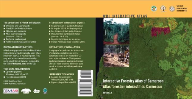
Atlas forestier interactif
Dissémination données et informations
Initiatives régionales
FORCOMS, COMIFAC, PFBC, RAPAC, etc.
Produits
Comment accéder aux données et informations ?
Mécanismes de diffusion
Produits distribué largement aux différents acteurs
Atlas distribué avec logiciel d’utilisation convivial
Ateliers de sensibilisation et formation
Disponible sur internet (WRI et Partenaires)
www.globalforestwatch.org
www.minef.cm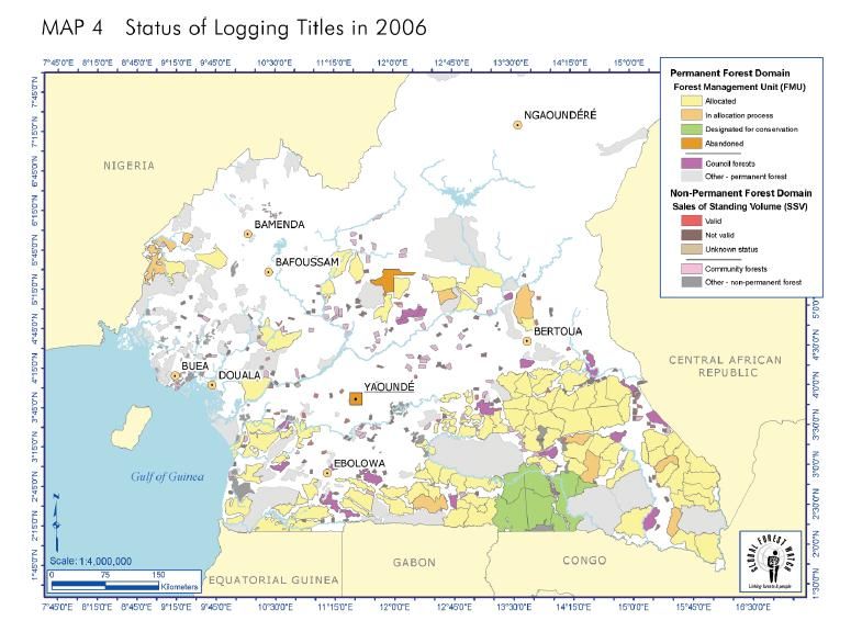
Informations disponibles
     Couches d’information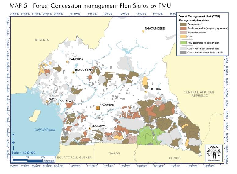
Informations disponibles
       Bases de données
Informations disponibles
Bases de données (2)Etat des lieux
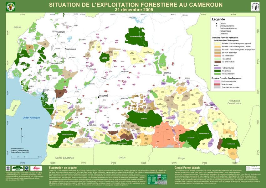
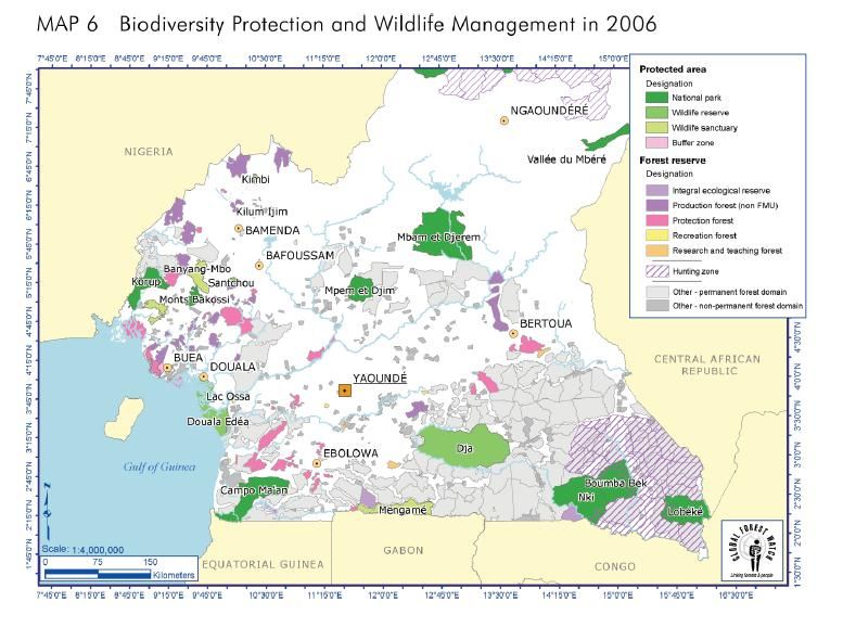
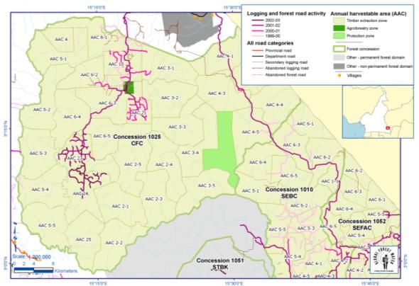
- Cartographie - Atlas -
Produit Pays Statut Perspectives 2007 Actions/
Contraintes
Cameroun Labo SIG opérationnel Transfert MINFOF Formations
Publication carte annuelle Mise à jour Accès données
C Maj. Réseau routier (DMC) - Images sat.
A Atlas V2 (in press) Atlas V3
R
T Congo Labo SIG opérationnel Renforcement Formations
O Carte annuelle (in press) Mise à jour Accès données
G Màj. routes (DMC) Images sat.
R Atlas V1 (en cours) Atlas V1
A
P Gabon Information Gap analysis -
H - Labo SIG opérationnel Mise en œuvre
I Atlas V. Pilote (en cours) Atlas V. Pilote MEFEPPN
E RDC Labo SIG (WB) Renforcement Formations
- Carte de situation Conversion titresEtat des lieux
- Bases de données – Outils de suivi -
Produit Pays Statut Perspectives 2007 Actions/
Contraintes
B Cameroun BD Conc. opérationnelle Transfert MINFOF Formations
A Lien SIGIF Mise à jour
S
E
S Congo BD Conc. opérationnelle Renforcement Formations
BD Stat (en cours) Suivi
D
E
Gabon Renforcement Mise en œuvre
D
O
BD Conc. Pilote MEFEPPN
N
N RDC Evaluation BD Stat Renforcement Formations
E
E
SCadre CARPE II
Actions spécifiques
Intermediate Result 1 Intermediate Result 2 Intermediate Result 3
Natural resources managed Natural resources governance Natural resources monitoring
sustainably strengthened institutionalized
Ind 1: Number of landscapes and Ind 1: Number of key new laws or Ind 1: Number of landscapes or other
other focal areas covered by policies for PAs, logging focal areas with forest cover
integrated land use plans concessions, and CBNRM assessments
Ind 2: Number of different use- passed or old laws and policies Ind 2: Assessment of capacity of Congo
zones (e.g., parks & PAs; reformed compared with a list of Basin (African) institutions to
CBNRM areas; forestry recommended or promoted collect and analyze information of
concessions; plantations) reforms adequate quality for
within landscapes with Ind 2: Number of NGO (and other civil decisionmaking
sustainable management society organizations) advocacy Ind 3: Content/quality analysis of annual
plans initiatives & activities “State of the Congo Basin Forest”
Ind 3: Number of countries recommended or promoted report
implementing surveillance reforms
system for illegal logging
Ind 4: Number of landscapes or
other focal areas
implementing bushmeat
surveillance systemCadre CARPE II
Participation - collaboration
Intermediate Result 1 Intermediate Result 2 Intermediate Result 3
Natural resources managed Natural resources governance Natural resources monitoring
sustainably strengthened institutionalized
Ind 1: Number of landscapes and Ind 1: Number of key new laws or Ind 1: Number of landscapes or other
other focal areas covered by policies for PAs, logging focal areas with forest cover
integrated land use plans concessions, and CBNRM assessments
Ind 2: Number of different use- passed or old laws and policies Ind 2: Assessment of capacity of Congo
zones (e.g., parks & PAs; reformed compared with a list of Basin (African) institutions to
CBNRM areas; forestry recommended or promoted collect and analyze information of
concessions; plantations) reforms adequate quality for
within landscapes with Ind 2: Number of NGO (and other civil decisionmaking
sustainable management society organizations) advocacy Ind 3: Content/quality analysis of annual
plans initiatives & activities “State of the Congo Basin Forest”
Ind 3: Number of countries recommended or promoted report
implementing surveillance reforms
system for illegal logging
Ind 4: Number of landscapes or
other focal areas
implementing bushmeat
surveillance systemProduits … à venir Atlas Forestier Interactif
Vous pouvez aussi lire