First results of the CRLN seismic network in the western Corinth Rift: evidence for old-fault reactivation
←
→
Transcription du contenu de la page
Si votre navigateur ne rend pas la page correctement, lisez s'il vous plaît le contenu de la page ci-dessous
C. R. Geoscience 336 (2004) 343–351
Tectonics
First results of the CRLN seismic network in the western
Corinth Rift: evidence for old-fault reactivation
Hélène Lyon-Caen a,∗ , Panayotis Papadimitriou b , Anne Deschamps c , Pascal Bernard d ,
Kostas Makropoulos b , Francesco Pacchiani a , Geneviève Patau d
a Laboratoire de géologie, École normale supérieure, 24, rue Lhomond, 75252 Paris cedex 05, France
b Department of Geophysics, University of Athens, Panepistimioupoli, Zografou, 15784, Greece
c UMR Géosciences Azur, CNRS/UNSA250, rue Albert-Einstein, 06560 Valbonne, France
d Laboratoire de sismologie, Institut de physique du Globe de Paris, 4, place Jussieu, 75252 Paris cedex 05, France
Received 17 November 2003; accepted after revision 1 December 2003
Written on invitation of the Editorial Board
Abstract
The 12 stations Corinth Rift Laboratory Seismological Network (CRLNET) aims at monitoring the seismicity (Ml > 1) in the
CRL area and at constraining the geometry of active structures at depth. Two years of microseismicity (2000–2001) recorded
by the CRLNET in the Aigion area shows: (1) background seismicity inside the Corinth rift at depth of 4.5–11 km, deepening
towards the north and no activity in the upper 4 km of the crust – this seismicity is not clearly related to major faults observed
at the surface –; (2) a swarm, 6 km south of the city of Aigion, associated with the Mw = 4.2, 8 April 2001 earthquake. This
earthquake occurred at 6 km depth, on a SW–NE oriented fault dipping 40◦ to the northwest and corresponds to normal faulting
with a right lateral component of slip. It likely occurred on an old structure reactivated in the present stress field. To cite this
article: H. Lyon-Caen et al., C. R. Geoscience 336 (2004).
2003 Académie des sciences. Published by Elsevier SAS. All rights reserved.
Résumé
Premiers résultats du réseau sismique (CRLN) de la partie ouest du rift de Corinthe : évidence de la réactivation
d’une ancienne faille. Le réseau de 12 stations sismologiques installées dans la région du Corinth Rift Laboratory (CRL)
permet de localiser la microsismicité (Ml > 1) de cette zone depuis avril 2000, avec une précision de l’ordre du kilomètre afin,
en particulier, de contraindre la géométrie des structures actives en profondeur. La microsismicité enregistrée correspond à une
sismicité de fond sous le golfe de Corinthe entre 4,5 et 11 km de profondeur, à laquelle se superpose une activité en essaims.
Les quatre premiers kilomètres de la croûte sont asismiques. La sismicité s’approfondit vers le nord et n’est pas directement
associée aux failles actives observées en surface. Le séisme du 8 avril 2001 (Mw = 4,2) s’est produit à 6 km de profondeur.
L’étude du mécanisme au foyer et des répliques indique qu’il s’est produit sur un plan de faille orienté SW–NE, plongeant vers
le nord-ouest à 40◦ . C’est un séisme en faille normale avec une composante décrochante dextre, qui s’est probablement produit
sur une ancienne structure réactivée dans le champ de contrainte actuel (extension ∼N10◦ ) et qui n’émerge pas en surface. Pour
citer cet article : H. Lyon-Caen et al., C. R. Geoscience 336 (2004).
2003 Académie des sciences. Published by Elsevier SAS. All rights reserved.
* Corresponding author.
E-mail address: Helene.Lyon-Caen@ens.fr (H. Lyon-Caen).
1631-0713/$ – see front matter 2003 Académie des sciences. Published by Elsevier SAS. All rights reserved.
doi:10.1016/j.crte.2003.12.004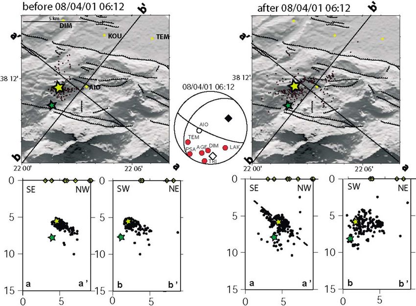
344                                          H. Lyon-Caen et al. / C. R. Geoscience 336 (2004) 343–351

Keywords: Corinth Rift; seismicity; extension; active faults

Mots-clés : rift de Corinthe ; extension ; sismicité ; failles actives

Version française abrégée                                                    in order to monitor the microseismicity of the Corinth
                                                                             Rift Laboratory (CRL) area. This network (CRLN) is
    Un réseau de 12 stations sismologiques (CRLN)                            complementary to other existing network in the area
a été installé en avril 2000 dans la zone d’étude du                         (PATNET run by the University of Patras, CORNET
Corinth Rift Laboratory (CRL), afin de contraindre la                        and ATHNET run by the University of Athens) that
géométrie des failles en profondeur dans cette région                        record the seismicity down to Ml magnitude 2.5 or 3.
où l’activité sismique est importante et le taux de                          The primary objective of this network is to provide
déformation élevé. Le réseau, équipé de sismomètres                          continuous monitoring of the seismicity and accurate
2 Hz dont une partie est installée dans des forages de                       locations of events down to magnitude 1 in order to
60–100 m, enregistre en continu à 125 Hz et localise                         constrain active structures at depth in this restricted
les événements de magnitude supérieure à 1. D’avril                          area.
2000 à décembre 2001, la sismicité enregistrée est                              In this paper we briefly analyse 2 years of seismic
importante (plus de 2000 événements localisés dans                           activity (April 2000–December 2001) and present a
le réseau, avec une précision standard de l’ordre de                         detailed study of the seismic crisis 6 km south of
1 km dans les trois directions) et se caractérise de                         Aigion, that started in February 2001 and culminated
la manière suivante : d’une part, une sismicité de                           with a Mw = 4.3 event on April 08.
fond sous le golfe de Corinthe même ; d’autre part,
plusieurs essaims de sismicité, dont le plus important
est associé à un séisme de magnitude Mw = 4,2,                               2. Seismotectonic framework
situé à 6 km au sud d’Aigion. L’activité sismique est
confinée entre 4,5 et 11 km de profondeur. Les quatre                            The Corinth Rift has long been recognised to be
premiers kilomètres de la croûte sont asismiques, et la                      one of the most seismically active area in Europe and
profondeur des séismes augmente vers le nord. Cette                          a large amount of recent tectonic, geodetic and seis-
sismicité n’est pas clairement reliée aux failles actives                    mological observations have contributed to provide a
connues affleurant en surface. Elle définit plutôt une                       fairly detailed seismotectonic framework (e.g., [1,2,5,
zone de déformation entre 6 et 10 km de profondeur,                          6,8,17]). From east to west, most of the largest active
sur laquelle pourraient se brancher les failles normales                     faults outcropping on land are located on the southern
actives. L’étude des répliques du séisme du 8 avril                          edge of this asymmetric rift and dip ∼ 60 ◦ to the north
2001 (Mw = 4,2) associées au mécanisme au foyer                              (Fig. 1). The deformation, as seen from GPS observa-
de ce séisme, montre qu’il s’est produit à 6 km                              tions, is very localised. The extension is ∼N10◦ and
de profondeur sur un plan de faille orienté ∼SW–                             its rate varies from less than 1 cm yr−1 in the east to
NE, plongeant vers le nord–ouest à 40◦ . Il s’agit                           ∼ 1.5 cm yr−1 to the west in the Aigion area.
d’un séisme en faille normale, avec une composante                               All large earthquakes (magnitude > 5.8) occurring
décrochante dextre, qui s’est probablement produit sur                       in the rift show almost pure normal faulting (Fig. 1)
une ancienne structure réactivée dans le champ de                            with a T-axis oriented ∼N10◦ . In the eastern part of
contrainte actuel (extension ∼N10◦ ) et qui n’émerge                         the rift, the 1981 Corinth earthquakes are clearly asso-
pas en surface.                                                              ciated with major active faults observed at the surface
                                                                             (e.g., [9,10]). In the west around Aigion, although the
                                                                             Helike fault is known to be responsible for major de-
1. Introduction                                                              structive earthquakes (e.g., the Ms ∼ 7 1861 event [11,
                                                                             13,14]), the two most recent largest earthquakes in the
   In April 2000, a semi-permanent seismological                             Aigion area, the Ms = 5.8 Galaxidi event of 8 Novem-
network of 12 stations was installed in the Aigion area                      ber 1992 [7] and the Ms = 6.2 Aigion event of 15 June
H. Lyon-Caen et al. / C. R. Geoscience 336 (2004) 343–351                                          345

Fig. 1. Seismotectonic map of the Corinth Rift. Fault-plane solutions of events with magnitude larger than 5.8 since 1960 are taken from [3,4,7].
Fig. 1. Carte sismotectonique du rift de Corinthe. Les mécanismes au foyer des événements d’une magnitude supérieure à 5,8 depuis 1960 sont
issues de [3,4,7].

1995 [4] were not clearly associated with surface fault-                    3. The Corinth Rift Laboratory seismological
ing. Both however indicate normal faulting on fairly                        network
low angle (30–35◦) north-dipping fault planes.
    The microseismic activity in the Aigion-Patras area                        The network is made up of seven stations in-
is very large and Rigo et al. [17], based on the results                    stalled on the southern coast of the gulf and of
of a two months recording experiment, proposed that                         5 stations on the northern coast (Fig. 2). Because
the microseismicity concentrates at depths between                          we wanted to be able to monitor small magnitude
6 and 11 km in places where major steeply dipping                           events, we installed the velocimeters from the seven
faults observed at the surface seem to root on a more                       southern stations in 60–130-m deep boreholes in
or less horizontal shear deformation zone. Relocation                       order to avoid very soft soils and human activity
of few multiplets [16] indicated that some events                           noise, which is quite large in the Aigion plain. How-
may represent normal slip on very shallow planes                            ever, only at AIO station could we succeed in in-
(∼ 15◦ ) in this shear zone. Alternatively, Hatzfeld et                     stalling the seismometer directly on the limestone.
al. [8] interpreted this seismicity as the expression                       The borehole seismometers were installed in two
of the ductile-transition zone without any peculiar                         steps, four stations in April 2000 (ALI, TEM, KOU
structure.                                                                  and AIO) and three additional ones in March 2001
    At present it is not easy to reconcile the various                      (AGE, DIM and ELE). The limestone is directly ex-
observations described above in a consistent scheme.                        posed on the northern side and some velocimeters
Part of the reason is that some conclusions are being                       are burried in shallow 2-m-deep holes. Seismome-
drawn from local observations over short periods of                         ters have a velocity response peaked at a natural fre-
time that may or may not be representative of a                             quency of 2 Hz. The signal, sampled at 125 points
large-scale process. Continuous observation of the                          per second, is recorded continuously by TITAN3NT
seismicity with the Corinth Rift Laboratory Network                         recorders. Data are stored on site and regularly gath-
should then help to obtain over time a clearer view of                      ered and sent to IPGP in Paris and to NUA in
the active structures at depth.                                             Athens.
346 H. Lyon-Caen et al. / C. R. Geoscience 336 (2004) 343–351 Fig. 2. Left: map of the CRLN seismological network (stations in yellow), including events located by the network from April 2000 to December 2001. All events plotted are located using at least 5P and 4S arrivals, have a rms < 0.1 s and standard errors in latitude, longitude and depth smaller than 1 km. Active faults in the Aigion area are from [14], offshore faults from [15]. Distribution of Ml magnitudes is shown on the right corner. Right: vertical cross-sections as indicated on the map. Major normal faults are indicated on cross-sections. Fig. 2. À gauche : carte du réseau sismologique CRLN (stations en jaune), incluant des événements localisés par celui-ci entre avril 2000 et décembre 2001. Tous les événements représentés ont été localisés en utilisant au moins les arrivées 5P et 4S, ont un rms < 0.1 s et des erreurs standard en latitude, longitude et profondeur inférieures à 1 km. Les données relatives aux failles actives dans la région d’Aigion sont issues de [14], celles relatives aux failles offshore de [15]. La distribution des magnitudes Ml est donnée dans le coin droit. À droite : coupes verticales selon les plans dessinés sur la carte. Les failles normales majeures sont indiquées sur les coupes. These 12 stations are complemented by two sta- earthquakes. About 2000 events were located with tions from ATHNET run by the University of Athens at least 5P and 4S phase readings, standard loca- (LAK and DAP). We also integrate in our dataset ob- tion errors smaller than 1 km in all directions and servations made at one station (SER) by the Prague rms smaller than 0.1 s (Fig. 2). Various tests, in- University in collaboration with the Patras University. cluding velocity structure perturbations and initial Overall, the Aigion area is fairly well covered although depth and location perturbations have been performed. one station closing the network to the west on the They indicate that the combination of the above cri- southern coast would be useful. teria leads to stable locations with errors less than From April 2000 to December 2001, over 6000 1 km in all directions for events inside the network. earthquakes were recorded by a mean of eight sta- Errors could be larger (up to 2 km) for events of tions and located within the network. We use the 1D 8 April 2001 swarm when observations at AIO are not velocity model from Rigo et al. [17] to locate the present.
H. Lyon-Caen et al. / C. R. Geoscience 336 (2004) 343–351                                347

4. Seismic activity                                                    made in 1991 but at the time it was not clear whether
                                                                       this was an artefact from the network configuration or
   Fig. 2 shows the best-located events recorded from                  not. Even after the 8 April 2001 event that occurred at
April 2000 to December 2001. Seismicity is mainly                      5.5 km depth, no activity above 4.5 km was observed.
concentrated inside the gulf itself with the exception of              For the Helike and the Aigion faults this observation
the swarm activity associated with the Mw = 4.2 event                  is consistent with the fact that these faults appear to be
south of Aigion. For comparison, seismicity recorded                   locked from GPS and interferometry studies [2,5]. The
during two months in 1991 [8,17] is shown on Fig. 3.                   lack of shallow activity under the gulf itself, although
   As in 1991, most events are located at depth be-                    less well resolved than on shore, is more surprising.
tween 4.5 and 11 km confirming that the seismogenic                    Given the very large strain rate in the gulf itself that
layer is very thin [17]. This is also consistent with                  needs to be accommodated in part by some kind of
the initiation depth of large earthquakes such as the                  shallow creep [4], one would expect some shallow
1992 Galaxidi and the 1995 Aigion earthquakes being                    seismicity there.
at ∼ 10 km [4,7].                                                          The seismicity deepens towards the north and
   The upper part of the crust is aseismic. The number                 defines a zone of deformation including some cluster
of seismic stations in the area of the Aigion and Helike               activity at 6–10 km depth on which large normal faults
fault is large enough to be able to detect any small                   could branch. Comparison of Figs. 2 and 3 shows that
shallow activity. During the two-year period studied                   these clusters move around with time. It also indicates
here, only five events have been located at depth                      that CRLN has a better resolution for events located
shallower than 4.5 km. A similar observation was                       below the gulf, due to the station density close to the

                           Fig. 3. Same as Fig. 2 for the seismicity recorded in July–August 1991 [8,17].
                            Fig. 3. Idem Fig. 2, pour la sismicité enregistrée en juillet–août 1991 [8,17].
348 H. Lyon-Caen et al. / C. R. Geoscience 336 (2004) 343–351
(a) (b)
Fig. 4. (a) Waveforms recorded at AIO for the Mw = 4.2, 8 April 2001 event, with a zoom on P1 and P2 arrivals. (b) Comparison of the P
phases (P1 and P2) at AIO and LAK. Note that timing and amplitude ratio of P1 and P2 are similar at these two stations.
Fig. 4. (a) Formes d’onde enregistrées à AIO pour l’événement de magnitude 4,2 du 8 avril 2001, avec un zoom sur les arrivées P1 et P2.
(b) Comparaison des phases P (P1 et P2) à AIO et LAK. Remarquer que les temps d’arrivée et les rapports d’amplitude de P1 et P2 sont
similaires pour ces deux stations.
gulf border. It is however difficult to know how this above the swarm activity allows us to have a large
seismicity relates to the main faults observed at the amount of well-located events (errors < 1 km). In par-
surface. More detailed studies of this seismicity (e.g., ticular the depths of events are well constrained by the
very precise locations using multiplets analysis) are S-P arrival times at AIO. A difficulty however arises
necessary to try to answer this question. This work for the location of the main event that was recorded
in progress [12] will be presented elsewhere. We will by eight stations, due to the complexity of the seismic
focus here on the swarm of seismic activity that lasted signal recorded (Fig. 4). As can be seen on AIO and
for more than 6 months, ∼ 6 km south of the city of LAK recordings shown, two clear P arrivals (denoted
Aigion. P1 and P2) can be detected, separated by ∼ 0.35 s. P2
has an amplitude 6 to 7 times larger than P1, but is very
5. The 2001 swarm and the Mw = 4.2, 8 April similar in waveform. P1 and P2 can fairly well be as-
2001 event sociated with S1 and S2 phases shown on AIO record-
ing. P1 and P2 are also seen on other stations, but
The activity began slowly in February 2001, accel- less clearly, as they are further away from hypocen-
erated on 25 March and culminated on 8 April with ter. The time separation between these two phases is
the Mw = 4.2 event at 06:12 [19]. The activity was less clearly measurable but is always between 0.3 and
then high for about three months and slowly decayed. 0.4 s. Originally, as it was the P1 and S2 phases (the
5.1. Location two best visible phases on the records) that had been
picked for locating this event, the location (green star
Although this swarm is located somewhat on the in Fig. 5) fell outside the foreshocks and aftershocks’
edge of our network, the presence of AIO station just cloud. Taking P2 and S2 phases, the new locationH. Lyon-Caen et al. / C. R. Geoscience 336 (2004) 343–351 349
Fig. 5. Foreshocks and aftershocks of the 8 April 2001 event located by at least 5P and 4S phases (including AIO station), with rms < 0.1 s and
standard errors in latitude, longitude and depth less than 1 km. Fault plane solution with polarities observed at CRLN stations is from Zahradnik
et al. [19]. Open (black) square indicate T (P) axis. The green star indicates original mainshock location and the yellow one revised location
(see discussion in the text). Dashed line on vertical cross-section indicates N220◦ , 40◦ NW dipping fault plan.
Fig. 5. Précurseurs et répliques de l’événement du 8 avril 2001, localisé avec au moins 5P et 4S (y compris la station AIO), avec rms < 0.1 s et
des erreurs standard en latitude, longitude et profondeur inférieures à 1 km. Les mécanismes au foyer avec les polarités observées aux stations
CRLN est issue de Zahradnik et al. [19]. Les carrés évidés (noirs) indiquent l’axe T (P). L’astérisque verte indique la localisation initiale du
choc principal et l’astérisque jaune la localisation révisée (voir la discussion dans le texte). La ligne en tiretés sur la coupe verticale indique un
plan de faille orienté N220◦ , plongeant vers le nord-ouest à 40◦ .
(rms = 0.06 s) is shown with the yellow star and falls shocks are concentrated in space, in an area ∼ 2 km ×
in the middle of the events’ cloud. 2 km, somewhat larger than the expected rupture area
for the main event (1 km × 1 km). Aftershocks are
5.2. Active fault plane more dispersed, but have a clear spatial distribution:
they align well on a SW–NE plane dipping ∼ 40◦ to
Fig. 5 shows best-located foreshocks and after- the northwest; on the contrary, no well-defined plane
shocks for the whole swarm. In addition to selection appears on north–south cross-sections. Aftershocks
criteria retained for Fig. 4, only events for which AIO extend over about 5 km along this plane, from depths
phases were available have been used, which insures of ∼ 4.5 km to 7.5 km, the mainshock being located
errors less than 1 km in the three directions. Fore- more or less in the middle of this activated zone. This350 H. Lyon-Caen et al. / C. R. Geoscience 336 (2004) 343–351
plane is in agreement with the preferred fault plane so- at a depth between 6 and 10 km, slightly deepening
lution of the 8 April 2001 event obtained by Zahrad- towards the north; no earthquake occurs in the upper
nik et al. [19] from inversion of amplitude spectra of 4 km of the crust. The detailed analysis of the swarm
close broad band stations (strike = 220◦ , dip = 40◦ , associated with the Mw = 4.2 event shows that it is
slip = −160◦ ). This fault plane solution is shown in associated with a SW–NE oriented fault dipping 40◦ to
Fig. 5, along with observed polarities of CRLN sta- the northwest. Such activity, rather unexpected in the
tions. The agreement of our observations with Zahrad- present-day tectonic context of the area, is important to
nik et al.’s results, strongly suggests that the fault re- document. In this context, the dense dataset provided
sponsible for the 8 April 2001 Mw = 4.2 event is a by CRLN provides useful recordings of moderate-
SW–NE oriented fault, dipping 40◦ to the northwest. sized events such as the ones studied. These events
Slip on this fault is oblique, with a normal and a right may be used to map active faults in detail, whether or
lateral component. not they happen to break the surface.
Such a faulting is rather surprising in a context
where all major active faults have azimuths of ∼ 100◦
and dip to the north. In fact, the 8 April fault cannot Acknowledgements
be associated with any faults mapped at the surface.
If extended up to the surface, this fault plane should The CRLN equipment was funded by INSU–CNRS
intersect the Pirgaki fault. During the swarm activity, in France. We would like to thank F. Cornet for
there is no evidence that the seismicity spreads out and his very important input in the installation phase of
branches on the Pirgaki fault. It looks as if these two the borehole seismometers. We also thank D. Brunel,
faults were somewhat decoupled one from each other, H. Castarède, C. Deléglise, G. Oganecian, J. Sell-
which could indicate that the Pirgaki fault is rather ier, and R. Verhille for their help at various stages
shallow and does not reach deeper than about 5 km, in the installation of the network. Maintenance of the
as suggested by Sorel [18]. network by N. Germinis and C. Skarpelos has been
Although surprising, this fault plane solution in- possible through EC environment program, seismic
dicates an almost horizontal T axis oriented N176◦ ,
hazard, CORSEIS contract EVG1-CT99-00002 and
which is very consistent with the overall state of stress
through GDR-Corinthe. Part of the data analysis pre-
of the area. One possibility is that this event is asso-
sented here was done under EC CORSEIS contract
ciated with the reactivation of an older structure in
and IST program, AEGIS contract IST-2000-26450.
the present stress field. The azimuth of the fault plane
We are grateful to J. Zahradnik for letting us use
is close to the main direction of the Hellenides and
the data from SER station and for stimulating discus-
the earthquake may have reactivated some old thrust
sions.
active at the time of the Hellenides formation. Alter-
We thank I. Main and D. Hatzfeld for reviewing the
natively, this event could be interpreted as a transfer
manuscript.
faulting between the Helike and the Mamoussia fault,
although no geological evidence of such a faulting ex-
ists.
References
[1] R. Armijo, B. Meyer, G. King, A. Rigo, D. Papanastassiou,
6. Conclusions
Quaternary evolution of the Corinth Rift and its implications
for the Late Cenozoic evolution of the Aegean, Geophys. J.
The image of the seismicity recorded in the Aigion Int. 126 (1996) 11–53.
area during the two-year activity of CRLN is bimodal: [2] A. Avallone, P. Briole, A.M. Agatza-Balodimou, H. Billiris,
a background seismicity within the Corinth gulf and an O. Charade, C. Mitsakaki, A. Nercessian, K. Papazissi, D. Pa-
radissis, G. Veis, Analysis of eleven years of deformation
earthquake swarm 6 km south of Aigion. In both cases,
measured by GPS in the Corinth Rift Laboratory area, C. R.
the seismicity is not directly associated with major Geoscience 336 (2004) 301–311, this issue.
known active faults that can be mapped at the surface. [3] C. Baker, D. Hatzfeld, H. Lyon-Caen, E. Papadimitriou, A. Ri-
Most of the seismicity occurring inside the gulf is go, Earthquake mechanisms of the Adriatic Sea and westernH. Lyon-Caen et al. / C. R. Geoscience 336 (2004) 343–351 351
Greece: implications for the oceanic subduction–continental the Corinth earthquakes of February and March 1981, Earth
collision transition, Geophys. J. Int. 131 (1997) 559–594. Planet. Sci. Lett. 57 (1982) 377–397.
[4] P. Bernard, P. Briole, B. Meyer, H. Lyon-Caen, J.-M. Gomez, [11] N. Mouyaris, D. Papastamatiou, C. Vita-Finzi, The Helice
C. Tiberi, C. Berge, R. Cattin, D. Hatzfeld, C. Lachet, B. Le- Fault, Terra Nova 4 (1992) 124–129.
brun, A. Deschamps, F. Courboulex, C. Laroque, A. Rigo, [12] F. Pacchiani, H. Lyon-Caen, S. Bourouis, P. Bernard, A. Des-
D. Massonnet, P. Papadimitriou, J. Kassaras, D. Diagourtas, champs, P. Papdimitriou, K. Makropoulos, Relocation of the
K. Makropoulos, G. Veis, E. Papazisi, C. Mitsakaki, V. Ka- microseismicity in the Corinth Rift and implications on the
rakostas, E. Papadimitriou, D. Papanastassiou, G. Chouliaras, faulting geometry, EGU, April 2003.
G. Stavrakakis, The Ms = 6.2, June 15, 1995 Aigion Earth- [13] D. Pantosti, M. De Martini, I. Koukouvelas, L. Stamatopou-
quake (Greece): evidence for low angle normal faulting in the los, S. Pavlides, N. Palyvos, S. Pucci, F. Lemeille, Palaeoseis-
Corinth Rift, J. Seismol. 1 (1997) 131–150. mological trenching across the Aigion Faults (Gulf of Corinth,
[5] P. Briole, A. Rigo, H. Lyon-Caen, J.C. Ruegg, K. Papazissi, Greece), C.R. Geoscience 336 (2004) 335–342, this issue.
C. Mitsakaki, A. Balodimou, G. Veis, D. Hatzfeld, A. De- [14] D. Pantosti, N. Palyvos (Eds.), Eliki and Aigion fault GIS data
schamps, Active deformation of the Corinth Rift, Greece: base, E.C. Corseis project, http://www.ingv.it/~wwwpaleo/
results from repeated Global: Positioning System surveys pantosti/aigion/database.
between 1990 and 1995, J. Geophys. Res. 105 (2000) 25605–
[15] D. Papanikolaou, M. Alexandri, P. Nomikou, D. Ballas, Mor-
25625.
photectonic structure of the western part of the North Aegean
[6] P.J. Clarke, et al., Geodetic estimation of seismic hazard in the
Basin based on swath bathymetry, Mar. Geol. 190 (2002) 465–
Gulf of Corinth, Geophys. Res. Lett. 24 (1997) 1303–1306.
492.
[7] D. Hatzfeld, D. Kementzetzidou, V. Karakostas, M. Ziazia,
S. Nothard, D. Diagourtas, A. Deschamps, G. Karakaisis, P. Pa- [16] A. Rietbrock, C. Tiberi, F. Scherbaum, H. Lyon-Caen, Seis-
padimitriou, M. Scordilis, R. Smith, N. Voulgaris, S. Kirat- mic slip on a low-angle normal fault in the Gulf of
zi, K. Makropoulos, M.P. Bouin, P. Bernard, The Galaxidi Corinth: evidence from high resolution cluster analysis of mi-
earthquake of 18 November 1992: a possible asperity within croearthquakes, Geophys. Res. Lett. 14 (1996) 1817–1820.
the normal fault system of the Gulf of Corinth (Greece), Bull. [17] A. Rigo, H. Lyon-Caen, R. Armijo, A. Deschamps, D. Hat-
Seismol. Soc. Am. 86 (1996) 1987–1991. zfeld, K. Makropoulos, P. Papadimitriou, I. Kassaras, A mi-
[8] D. Hatzfeld, V. Karakostas, M. Ziazia, I. Kassaras, E. Pa- croseismic study in the western part of the Gulf of Corinth
padimitriou, K. Makropoulos, N. Voulgaris, C. Papaioannou, (Greece): implications for large scale normal faulting mech-
Microseismicity and faulting geometry in the Gulf of Corinth anisms, Geophys. J. Int. 126 (1996) 663–688.
(Greece), Geophys. J. Int. 141 (2000) 438–456. [18] D. Sorel, A Pleistocene and still-active detachment fault and
[9] A. Hubert, G. King, R. Armijo, B. Meyer, D. Papanastassiou, the origin of the Corinth–Patras rift, Greece, Geology 28
Fault reactivation, stress interaction and rupture propagation (2000) 83–86.
of the 1981 Corinth earthquake sequence, Earth Planet. Sci. [19] J. Zahradnik, J. Jansky, E. Sokos, A. Serpetsidaki, H. Lyon-
Lett. 142 (1996) 573–585. Caen, P. Papadimitriou, Modeling the ML = 4.7 mainshock
[10] J. Jackson, et al., Seismicity, normal faulting and the geo- of the February–July 2001 earthquake sequence in Aigion,
morphological development of the Gulf of Corinth (Greece): Greece, J. Seismol. (in press).Vous pouvez aussi lire