Stratication at the Health District Level for Targeting Malaria Control Interventions in Mali
←
→
Transcription du contenu de la page
Si votre navigateur ne rend pas la page correctement, lisez s'il vous plaît le contenu de la page ci-dessous
Strati cation at the Health District Level for
Targeting Malaria Control Interventions in Mali
Cissoko Mady
 Aix Marseille Univ, INSERM, IRD, SESSTIM, ISSPAM, UMR1252, 13005 Marseille, France
Mahamadou Magassa
 Programme National de Lutte contre le Paludisme (PNLP), Bamako 233, Mali
Vincent Sanogo
 Programme National de Lutte contre le Paludisme (PNLP), Bamako 233, Mali
Abdoulaye Ouologuem
 Institut National de la santé Publique (INSP) Bamako 1771, Mali
Lansana Sangaré
 Laboratoire de Biologie Médical Appliqué (LBMA), E2283 Bamako, Mali
Modibo Diarra
 Malaria Research and Training Center (MRTC), FMOS-FAPH, Mali-NIAID-ICER, Université des Sciences,
des Techniques et des Technologies de 1805 Bamako, Mali
Cedric Bationo
 Aix Marseille Univ, INSERM, IRD, SESSTIM, ISSPAM, UMR1252, 13005 Marseille, France
Amagoron Dolo
 Malaria Research and Training Center (MRTC), FMOS-FAPH, Mali-NIAID-ICER, Université des Sciences,
des Techniques et des Technologies de 1805 Bamako, Mali
Mamadou Bah
 President’s Malaria Initiative (PMI) VectorLink Project City Niger, 612 Bamako, Mali
Sidy Doumbia
 Malaria Research and Training Center (MRTC), FMOS-FAPH, Mali-NIAID-ICER, Université des Sciences,
des Techniques et des Technologies de 1805 Bamako, Mali
Mamadou Coulibaly
 Malaria Research and Training Center (MRTC), FMOS-FAPH, Mali-NIAID-ICER, Université des Sciences,
des Techniques et des Technologies de 1805 Bamako, Mali
Diahara Traoré
 Programme National de Lutte contre le Paludisme (PNLP), Bamako 233, Mali
Boubacar Sidibé
 Organisation mondiale de la Santé au Mali, 99 Bamako, Mali
Jordi Landier
 Aix Marseille Univ, INSERM, IRD, SESSTIM, ISSPAM, UMR1252, 13005 Marseille, France
Idrissa Cissé

Programme National de Lutte contre le Paludisme (PNLP), Bamako 233, Mali Moussa Sacko Institut National de la santé Publique (INSP) Bamako 1771, Mali Jean Gaudart ( jean.gaudart@univ-amu.fr ) Aix Marseille Univ, APHM, INSERM, IRD, SESSTIM, ISSPAM, UMR1252, Hop Timone, BioSTIC, Biostatistic & ICT, 13005 Marseille, France Issaka Sagara Malaria Research and Training Center (MRTC), FMOS-FAPH, Mali-NIAID-ICER, Université des Sciences, des Techniques et des Technologies de 1805 Bamako, Mali Research Article Keywords: Strati cation, Malaria, Interventions, geo-epidemiology, environment, Mali Posted Date: July 31st, 2021 DOI: https://doi.org/10.21203/rs.3.rs-653056/v3 License: This work is licensed under a Creative Commons Attribution 4.0 International License. Read Full License
1 Stratification at the Health District Level for Targeting Malaria Control Interventions in
2 Mali

 3 Mady Cissoko1,2,3, Mahamadou Magassa4, Vincent Sanogo4, Abdoulaye Ouologuem5, Lansana Sangaré6, Modibo Diarra1,
 4 Cedric Stephane Bationo3, Amagoron dit Mathias Dolo1, Mamadou D. Bah7, Sidy Doumbia1, Mamadou B. Coulibaly1, Diahara
 5 Traoré4, Boubacar Sidibé8, Jordi landier3, Idrissa Cissé4, Moussa Sacko5, Jean Gaudart9*, Issaka Sagara1,3.

 6 Affiliations :

 7 1 Malaria Research and Training Center (MRTC), FMOS-FAPH, Mali-NIAID-ICER, Université des Sciences, des Techniques et des
 8 Technologies de 1805 Bamako, Mali.
 9 2 Direction Régionale de la Santé de Tombouctou, 59 Tombouctou, Mali
10 3 Aix Marseille Univ, INSERM, IRD, SESSTIM, ISSPAM, UMR1252, 13005 Marseille, France
11 4 Programme National de Lutte contre le Paludisme (PNLP), Bamako 233, Mali
12 5 Institut National de la santé Publique (INSP) Bamako 1771, Mali.
13 6 Laboratoire de Biologie Médical Appliqué (LBMA), E2283 Bamako, Mali.
14 7 President’s Malaria Initiative (PMI) VectorLink Project City Niger, 612 Bamako, Mali.
15 8 Organisation mondiale de la Santé au Mali, 99 Bamako, Mali
16 9 Aix Marseille Univ, APHM, INSERM, IRD, SESSTIM, ISSPAM, UMR1252, Hop Timone, BioSTIC, Biostatistic & ICT, 13005
17 Marseille, France

18 * Corresponding author: Jean Gaudart, Email: jean.gaudart@univ-amu.fr

19 Abstract

20 Introduction

21 Malaria has been the main cause of morbidity and mortality in Mali, with an increase from 2017 to 2020
22 (2,884,837 confirmed cases and 1,454 deaths). On the recommendation of the World Health
23 Organization (WHO) and for efficient use of resources, Mali has begun a process of malaria
24 stratification.

25 Method

26 Malaria, entomological and environmental data were collected through the local health information
27 system, the Demographic and Health Survey 2018, research institutions and MALI-METEO services.
28 The WHO stratification based on malaria incidence was used to present a stratified malaria risk map.
29 Environmental factors associated with malaria were identified using a general additive non-linear
30 regression model. The classification and regression tree method was used to improve the stratification.
31 Interventions were proposed according to the incidence stratification and the different environmental,
32 entomological, access to care maps.

33 Results

34 From 2017 to 2019, the median incidence across the 75 health districts was 129.34 cases per 1,000
35 person-year (IQR=86.48). Stratification resulted in 12 health districts of very low, 19 low, 20 moderates
36 and 24 in high transmission areas. Considering the environmental risk associated to malaria incidence,
37 6 environmental classes were selected. Four different strategies were proposed, from improving

 1
38 surveillance and response to epidemic in the very low and low zones, to access to care improvement in
39 the moderate and high zone.

40 Conclusion

41 This stratification in Mali will allow targeting malaria control strategies.

42 Keywords: Stratification, Malaria, Interventions, geo-epidemiology, environment, Mali.

43 Background
44 Malaria remains the leading cause of morbidity and mortality in Mali. In 2020, the surveillance system
45 reported 2,884,827 confirmed cases out of 4,252,213 people tested, of which 871,265 were severe cases,
46 still being the first reason for health care visits with 36% of consultation due to malaria 1. The number
47 of deaths was 1,454 notified by the health facilities. The main parasites responsible for malaria in Mali
48 are: Plasmodium falciparum (more than 85%), Plasmodium malariae (10-15%) and Plasmodium ovale
49 (1%) 2. However, cases of Plasmodium vivax have been observed and documented in Mali 3,4. Malaria
50 is endemic in most localities in Mali with an annual increase following the rainy season. The main vector
51 species are: Anopheles gambiae s.l. (Anopheles gambiae s.s., Anopheles coluzzii, Anopheles gambiae
52 and Anopheles arabiensis) and Anopheles funestus 5,6.

53 To control malaria, Mali has implemented a policy of prevention, monitoring and case management
54 coordinated at different levels by the National Malaria Control Program (NMCP) following the World
55 Health Organization (WHO) technical guidelines. The case management is concerned with the early
56 diagnosis of malaria by rapid diagnosis test (RDT) and prompt treatment. Preventive interventions are
57 vector control using insecticide-treated mosquito nets (ITNs) distributed every 3 years, and indoor
58 residual spraying (IRS). Seasonal Malaria Chemoprevention (SMC) has been progressively applied
59 since 2012, for children under 5 years old during the periods of high transmission (one per month from
60 July to October) using the Sulfadoxine-pyrimethamine (SP) associated to Amodiaquine (AQ).
61 Intermittent Preventive Treatment (IPT) with Sulfadoxine-pyrimethamine (SP) has been applied since
62 2000 for pregnant women from the 13th week of pregnancy.

63 WHO recommends that malaria-endemic countries adapt interventions as transmission evolves 7. The
64 intensity of malaria transmission is strongly dependent on environmental, socio-demographic
65 characteristics and the malaria interventions implemented 8–12. It is generally measured by the incidence
66 of cases or the prevalence of infection in the population.

67 Malaria stratification is defined as the classification of geographical areas according to similar
68 epidemiological, entomological, environmental and socio-economic factors, in order to guide malaria
69 control interventions 7. Health districts are classified according to the risk, based on factors that

 2
70 determine susceptibility and vulnerability to malaria transmission. These stratum or facies are places in
71 which malaria presents the same characteristics of transmission and incidences. Stratifying malaria
72 allows better targeting of malaria control strategies in Mali.

73 In 1989, Mali has been divided into 5 zones corresponding to the initial epidemiological facies
74 described: i) a Sudano-Guinean zone with a long seasonal transmission of 4 to 6 months; ii) a zone of
75 short seasonal transmission of 3 to 4 months; iii) a zone of sporadic or epidemic transmission in the
76 northern regions and some localities in the regions of Koulikoro, Segou, Mopti and Kayes; iv) zones of
77 bi or multimodal transmission including the inner delta of the Niger River and dam zones; v) zones that
78 are less propitious to malaria transmission, particularly in urban areas as Bamako and Mopti where
79 malaria was hypo endemic 13. Since 1989, these profiles have evolved, due to sociological and climatic
80 changes.

81 The aim of this study was to develop an updated stratification of malaria in Mali in order to target
82 interventions based on the intensity of transmission, environmental risk, vector resistance and
83 distribution.

84 Method
85 Study location
86 The Republic of Mali, a country located in West Africa and in the Sahelo-Saharan strip, has a population
87 of 20,536,999 inhabitants in 2020 and a growth rate of 3.36% (General Population, Habitat Survey 2009
88 in Mali -GPHS 2009-, updated by the National Population Direction). The relief is low, with an average
89 altitude of 500 meters, showing landscapes of plains and low plateaus. The hydrographic regime,
90 associated with the geographical profile from the 11° and the 25° north latitude, is constituted by the 2
91 basins of upper Senegal and Niger Rivers. There are several dams and flooded areas used for agriculture.
92 The flooded areas extend along the Niger River: the inner delta of the Niger River from the Segou region
93 in the center, through Mopti to the Timbuktu region in the north (Figure 1), and covers a maximum area
94 of 41,000 km2, including numerous lakes, ponds and swamps 14. Annual rainfall data measured vary
95 from less than 200 mm in the Saharan desertic zone to more than 1100 mm in the pre-Guinean zone
96 (Figure 1): desertic zone (less than 200 mm), Sahelian zone (200 to 600 mm), Sudanian zone (600 to
97 800 mm), Sudano-Guinean zone (800 to 1100 mm) and the pre-Guinean zone (more than 1100 mm) 15.

98

99 Figure 1: Different ecoclimatic zones in Mali (Source: MRTC GIS/RS).

 3
100 Mali is composed of 11 regions including the District of Bamako. The health system is divided into 75
101 health districts. The health system is structured following a 3-level pyramid (health district, regional and
102 national level).

103 Data collection
104 Clinical data

105 Malaria cases confirmed by a biological test (RDT or microscopy), notified monthly by the health
106 districts, were extracted from 2017 to 2019. The attendance rate was also collected into the District
107 Health Information Software 2 (DHIS2) platform by health districts. The child mortality data were
108 extracted from the Demographic and Health Survey (DHS).
109 The use of anonymous data was obtained from the National Malaria Control Program (NMCP) (DHIS2
110 data extractions), or from research institutions: Malaria Research and Training Center (MRTC),
111 Laboratory of Applied Molecular Biology (LBMA) and National Institute of Public Health (INSP).

112 Population data

113 Updated population data were obtained from the GPHS 2009 updated by the National Population
114 Direction, at the health district and regional levels.

115 Environmental data

116 Environmental data were collected from the MALI-METEO service (observational data from synoptic
117 and agrometeorological stations for the Center and South regions) and from the NASA - GIOVANNI
118 platform (giovanni.gsfc.nasa.gov/). The data collected were: the monthly rainfall in mm (IMERG 6,
119 resolution 1°), the monthly NDVI (MODIS-terra, resolution 0.05), the monthly maximum and minimum
120 temperature in Celsius degrees (AIRS, resolution 1°), the monthly relative humidity (AIRS, resolution
121 1°), the monthly soil moisture in m3 m-3 (MERRA-2, resolution 0.5 x 0.625°) and the monthly mean
122 wind speed in m/s (MERRA-2, resolution 0.5 x 0.625°) 16.
123 The land use data, i.e. percentage of cultivated area, percentage of urbanization, percentage of area
124 occupied by trees and surface water, were obtained from the 2017 Copernicus Africa classification 17.

125 Entomological data

126 The entomological data presented here includes data from 2010 to 2019, from Malaria Research and
127 Training Center (MRTC) and the NMCP partner (Vector Link) carried to the national sentinel sites
 5,6,18,19
128 . Two parameters were studied: vector distribution and vector resistance to insecticides to ten
129 insecticides in five classes (pyrethroids -PY-, organochlorines –OC-, organophosphates -OP-,
130 carbamates and neonicotinoids). The insecticides used were permethrin 0.75%, deltamethrin 0.05%,
131 alpha-cypermethrin 0.05% and lambda-cyhalothrin 0.05% (pyrethroids), DDT 4% (organochlorinated),
132 bendiocarb 0.1% and propoxur 0.1 (carbamates); pyrimiphos-methyl 0.25% and 1% and fenitrothion

 4
133 1% (organophosphates) and clothianidin 2% (neonicotinoid). The tests performed were bioassays 134 according to WHO recommendations [12] on the major malaria vector An. gambiae s.l.. 135 Data Analysis 136 Incidence and prevalence data were estimated and presented in maps, tables, and figures. 137 Temporal analysis 138 To determine the periods of transmission at the national level, the national malaria incidence time series 139 was split using the change point analysis of the mean. The algorithm PELT was used 20, allowing the 140 identification of periods of low and high transmission. 9,21,22 141 As the impacts of environmental determinants of malaria are well documented in Mali , 142 relationships between environmental factors and malaria incidence was assessed including time lags. 143 For this purpose, we provided synthetic environmental indices (SEI) by using principal component 144 analysis (PCA). This approach was necessary to consider the curse of dimensionality and collinearities 145 between variables. The number SEI was chosen according to the elbow criterion 23. 146 The relationships between synthetic environmental indices and malaria incidences were assessed by 147 using Generalized Additive Model (GAM), using Spline smoothing functions modeling non-linear 148 relationships, Negative-binomial distribution for count data considering overdispersion, and log 149 (Population) as offset to provide standardized incidence ratios (SIR). The time series of monthly 150 incidences was modeled as a function of environmental factors grouped into synthetic environmental 151 indices by the PCA method with a lag of 1 to 4 months. The criterion for selecting the best model was 152 the highest explained deviance and the lowest model generalized cross-validation score (GCV). 153 Spatial analysis 154 Monthly incidences were estimated using confirmed malaria cases reported by DHIS2 considering the 155 population size and time (month). 156 = × 1,000 (2) × 157 These crude estimations did not totally reflect the real incidence of the disease in the population for the 158 following reasons varying according to the health facilities: 159 Health facility access and usage rate 160 The availability and use of diagnostic tests 161 The low completeness of the databases by health facilities. 162 Adjusted incidences were estimated per 1,000 person-years by adjusting for the health district usage rate 163 as follow: 5
164 = ( ) × 100 (3)
 ℎ ℎ

165 = × 1,000 (4)
 ×

166 Stratification and targeting of interventions

167 To stratify malaria, we first used the WHO criteria to classify the health districts. This stratification was
168 improved in a second step by using meteorological and land use factors. These classes were determined
169 by Classification and Regression Trees (CART) 24.

170 Software and packages
171 The R software version 3.4 was used for the statistical analyses (R Development Core Team, R
172 Foundation for Statistical Computing, Vienna, Austria), using the following packages:
173 {mgcv}{caschrono}{FactoMineR}{forecast}{ggplot2}{party}{changepoint}. The ArcGIS Desktop
174 version 10.1 software (Environmental Systems Research Institute (ESRI), 380 New York Street,
175 Redlands, CA 92373-8100, USA) was used for mapping. The Paint.net software version 4.2.13 (Rick
176 Brewster and al., Washington State University, USA) was used for image treatment.

177 Results
178 Temporal
179 Low and high malaria transmission period

180 Time series analysis of the monthly malaria incidence showed the classical periodicity at the national
181 scale, with a lag according to the rainfall.

182

183 Figure 2: Malaria incidence time series, 2017-2019. Grey band: periods of high malaria transmission
184 (according to the change point analysis); Blue bars: rainfall (left y-axis, mm); Red curve: Malaria
185 incidence (y-right axis, cases/person-month); Black curve: average monthly temperature in a black (y-
186 right axis, °C) (Figure 2).

187

188 Relationship between malaria and environmental factors
189 Principal component analysis of environmental factors

190 The PCA analysis provided 2 synthetic environmental indices (SEI).

 6
191

192 Figure 3: synthetic indices from the Principal Component Analysis (PCA) of the different
193 meteorological factors.

194 PCA allowed to obtain two Synthetic Environmental Indices (SEI) with 87.7% inertia (Figure 3 Panel
195 a). SEI 1 was determined by rainfall, relative humidity, soil moisture and NDVI positively and wind
196 speed negatively. SEI 2 was mainly determined by temperatures (Figure 3, Panel b).

197

198 Uni and multivariate regression analysis

199 The univariate regression analysis by using general additive modeling (GAM) showed a month lag
200 between SEI 1 (rainfall, relative humidity, vegetation index and soil moisture) and malaria and no lag
201 between SEI 2 (temperature) and malaria incidence (Figure 4).

202 Considering these lags, the multivariate analysis showed a linear relationship between malaria incidence
203 and the SEI 1 (rainfall, NDVI, relative humidity and soil moisture) (p-value < 0.001), before reaching
204 an asymptote for high values (Figure 4, panel a). Malaria incidence decreased with high values of SEI
205 2 (temperatures) (p-value < 0.01) (Figure 4, panel b).

206

207 Figure 4: Changes in malaria incidence as a function of synthetic environmental indices; GAM
208 multivariate analysis (Figure 4).

209

210 Spatial analysis
211 Adjusted Malaria incidence

212 Annual adjusted malaria incidence at the health district level for 2019 was stratified into five (5) classes
213 per 1,000 person-years. The median incidence was 125.34 cases per 1,000 person-year with a standard
214 deviation of 86.48.

215

216 Figure 5: Annual malaria incidence at the health district level, adjusted for health facility access, Mali,
217 2019.

218 According to the WHO classification, the adjusted malaria incidence in 2019, Mali, was distributed as
219 follow (Figure 5 and Figure 13 panel B):

 7
220 12 out of 75 health districts in the zone of very low transmission with 100 cases per 1,000 221 person-years: 7 health districts showing incidences between 5 to 50 cases per 1,000 person- 222 years (located in the northern area) and 5 health districts showing incidences between 50 and 223 100 cases per 1,000 person-years (3 in the northern area, one in the western area, one in 224 Bamako); 225 19 out of 75 health districts in the low transmission zone; 226 20 out of 75 health districts in the moderate transmission zone; 227 24 out of 75 health districts in the high transmission zone (mainly in the southern and central- 228 western areas). 229 230 Rainfall 231 232 Figure 6: Map of average annual rainfall from 2017 to 2019 by health district in Mali. 233 The average annual rainfall from 2017 to 2019 varies from less than 200 mm in the desertic zone to 234 more than 1100 mm in the Sudano-Guinean zone, with a clear north to south trend. Within the 75 health 235 districts, 17 showed an average rainfall of less than 200 mm (desertic zone), 20 showed an average 236 rainfall between 200 and 600 mm (Sahelian zone), 10 showed an average rainfall between 600 and 800 237 mm, 21 showed an average rainfall between 800 and 1100 mm (Sudanese) and 7 health districts showed 238 an average rainfall above 1100 mm (Sudano-Guinean zone) (Figure 6). 239 240 Health facility access 241 The percentages of populations living outside a distance of 5-km from a health facility was high in 242 Mali, mainly in the northern areas, justifying the implementation of specific strategies to improve care 243 access (Figure 7). 244 Figure 7: Percentage of population outside at 5-km radius of a health facility in Mali 2019. 245 246 Prevalence of malaria in children aged 3-59 months 247 Figure 8: Malaria prevalence map of children aged 6-59 months according to DHS VI, Mali 2018. 248 Malaria prevalence according to DHS VI 2018 was 18.9% at the national level among children aged 6- 249 59 months in Mali. The prevalences were lower in the northern regions of Kidal, Taoudenit, Tombouctou 8
250 between 1 and 10% and the District of Bamako less than 1%. Two regions in the North such as Gao and
251 Ménaka showed a prevalence over 10%. The regions of Sikasso, Ségou and Mopti showed the highest
252 prevalence with 29.7%, 25.9% and 24.9% respectively (Figure 8).

253 Child mortality in Mali

254

255 Figure 9: Map of mortality of children under 5 years old from DHS 2018 survey in Mali.

256 The regions of Kidal and Gao and the District of Bamako showed the lowest mortality rates of 20, 78
257 and 55 per 1000 cases respectively (Figure 9).

258

259 Entomological maps

260 Figure 10: Malaria vector distribution map, 2010 - 2019. The sector diagrams show the presence of the
261 different species.

262 The malaria vectors found at the sentinel and research sites were distributed ubiquitously. These are An.
263 coluzzii, An. gambiae and An. arabiensis (to a lesser degree compared to the first two). In the northern
264 regions, Gao, Kidal and Timbuktu, the studies carried out were morphological identification, identifying
265 only An. gambiae s.l.. The An. funestus group was also encountered particularly in the area of Niono
266 and Mopti (inner delta) (Figure 10).

267

268 Figure 11: Map distribution of resistance of Anopheles gambiae s.l., a major malaria vector to different
269 insecticides from 2010 to 2019 in Mali. Red dots show the presence of insecticide resistance in the health
270 district, yellow dots show moderate sensitivity (below 90%) and green dots show a high sensitivity of
271 major vectors to insecticide.

272 High resistance to pyrethroids and organochlorines was observed in several health districts. Resistance
273 to carbamates (bendiocarb and propoxur) was also noted, although it appears to be less extensive than
274 resistance to pyrethroids. The bioassays showed that the major malaria vector was sensitive to
275 pyrimiphos-methyl (OP) and clothianidin (neoticotinoid). Sensitivity and resistance to fenitrothion (OP)
276 were noted in sentinel sites where entomological surveillance was carried out. Deltamethrine LLIN is
277 currently mainly distributed, whatever the resistance analyses. Pyrethroid-PBO combination-LLIN are
278 proposed for 2023 distributions (Figure 11).

 9
279 Stratification of malaria using adjusted incidence with environmental determinants in
280 Mali, health district level

281 The supervised classification (CART) provided 6 classes of malaria incidence based on environmental
282 factors (Figure 12). Vegetation (NDVI) was the first factor that split first the northern and the southern
283 part. Then, within the northern part, the classification identified a low vegetation area around the Niger
284 River (a West to East area from Niafunke to Inekar, class 3), showing an intermediate adjusted incidence
285 around 100 cases per 1000 person-year. The extreme north area (classes 1 and 2), with a very low
286 vegetation index (sahara area), were split according to the surface water factor (no surface water vs oases
287 or wadis), experienced adjusted incidences around 50 and 100 cases per 1000 person-year, respectively.

288 Within the southern part, with higher vegetation index, temperatures were the main factors to classify
289 the areas. Indeed, high nighttime temperature (>22°C) in the urbanized areas of Bamako and Kayes
290 (class 6) was associated with intermediate malaria adjusted incidence, around 150 cases per 1000
291 person-year. Then, near the Kayes area, the fifth class was associated with high daily temperature (above
292 37.48 °C), experiencing incidences around 250 cases per 1000 person-year. Finally, the major class
293 (class 4), with 41 health districts among 75, with high vegetation index and low night and day
294 temperature, experienced malaria adjusted incidences around 500 cases per 1000 person-year. This area
295 included the Niger River inner delta in central Mali, the Senegal River basin area (Senegal River and its
296 tributaries, south-west) and the Sudan-Guinean area (south).

297

298 Figure 12: Environmental supervised classification of malaria in Mali (CART). Class 1: Very low
299 vegetation and no surface water; Class 2: Very low vegetation around oases or wadis; Class 3: Low
300 vegetation around the northern part of the Niger River; Class 4: higher vegetation index, low night and
301 day temperatures (
316 Discussion
317 Malaria transmission was very heterogeneous between health districts, with, mainly, two transmission
 21 8,21,27,28
318 periods and associated with environmental factors (Figure 2 et 4). Malaria transmission is
319 characterized in some countries such as Burkina Faso by three periods of transmission with an
320 intermediate period 25. In the health districts located in the south with early and abundant rainfall, the
321 period of high transmission began from July to December with a monthly incidence of between 20 and
322 60 cases per 1,000 person-months 26. Health districts in the center, which were in the majority, had the
323 standard high transmission period from July to December with an incidence of between 10 and 30 cases
324 per 1,000 person-months. It represents the majority of health districts in Mali. For the northern health
325 districts, the high transmission period was late, starting in August or even September and ending in
326 January with an incidence drop for some in October. The incidence was often low, less than 5 cases per
327 1,000 person-months. These are generally health districts in the north and those located in flooded areas
328 (Dire, Niafunké, Youwarou, Bourem, Gao, Timbuktu) 21. A cohort study carried out in Bancoumana,
329 around 60 km south from Bamako, on the incidence of malaria confirmed these results with an incidence
330 of 760 per 1,000 person-years in 2019 in the general population, 530 cases per 1,000 person-years in
331 children under 5 years old and 890 cases per 1,000 for children aged 5 and 10 years old 30.

332 Mapping of the adjusted incidence showed that more than a third of the health districts of Mali are in
333 the zone of high transmission with more than 450 cases per 1,000 person-years. These health districts
334 are located in areas of high rainfall, along rivers and flooded areas. Health districts with moderate
335 transmission were generally located in the Sahel with an incidence from 250 to 450 cases per 1,000
336 person-years. Health districts in areas of low and very low transmission represent 41%. They were
337 located in areas of low rainfall (northern Mali) with a very low population density of less than one
338 habitat per km². They are located in northern Mali. A Study carried out in Dire, in the Sahelian zone of
339 Mali showed between incidence from 20 to 120 cases per 1,000 person-years 21. These low transmission
340 areas could be potential candidates for the use of the mass treatment administration strategy to move
341 towards malaria pre-elimination in Mali 29 (Figure 5-6).

342 The prevalence results of the DHS only concerned children aged 3-59 months in the different regions.
343 These results are in line with those of the incidence with low malaria prevalence in the northern regions
344 of Mali and the urban area of Bamako. Several studies have confirmed the low prevalence of malaria in
345 these areas due to the low density of malaria vectors linked to low rainfall on the one hand and
346 urbanization on the other. This is the case in other major cities in West Africa 31. But the low prevalence
347 of malaria does not take into consideration the peri-urban area with their specificity where the prevalence
 10
348 can be high or maintained . Adapted strategies must be made for these suburban areas to control
349 malaria. The percentage of the population living outside a 5-km radius of a health center remains very

 11
350 high in the majority of Mali's health districts (Figure 7). It is 40 to 60% in the health districts of the
351 center of the country and more than 80% in the northern health districts (Sahara zone).

352 Alternatives to improve accessibility outside of 5km, such as the introduction of community health
353 workers and malaria posts, should be developed to compensate for this lack of access to healthcare for
354 children and pregnant women. The involvement of these malaria poste in community diagnosis and
355 treatment of uncomplicated malaria can help in the control of malaria 32.

356 DHS mortality data showed a low infant and child mortality rate, under 100 deaths per 1,000 in the
357 northern regions and in Bamako, the capital, compared with 130 deaths per 1,000 in the southern regions
358 (Kayes, Sikasso, Ségou and Mopti). The region of Tombouctou in the north had 131 deaths per 1,000.
359 There was a sharp decline in mortality at the national level between 1987 and 2012, from 247 to 95
360 deaths per 1,000. It increased in 2018 to 101. This trend is found in the incidence data which have been
361 on the rise in recent years according to the WHO annual report on malaria 33 and a study carried out on
362 mapping child growth failure 34 (Figure 8-9).

363 The available data on malaria vectors was based on research in the sentinel sites. The authorities consider
364 these sites as representative of malaria transmission throughout the country. They carry out clinical,
365 parasitological, and entomological surveillance. Resistance to insecticides has been observed in the
366 majority of A. gambiae vectors, with the exception of two which are pyrimiphos-methyl in Koulikoro
 35,36
367 and Clothianidins (Neoticotinoid) 37. This resistance appears to be widespread in Mali and could
368 compromise the effectiveness of vector control. Long-lasting insecticidal nets (LLINs) and indoor
 38
369 residual spraying (IRS) is responsible for 70% of the reduction in malaria cases . The increase in
 39
370 resistance is pushing countries like Mali to use 2nd generation combination insecticides and to
371 increase surveillance on insecticides to continue to benefit from their efficacy (Figure 10-11).

372 The stratification of malaria in Mali was carried out based on incidence adjusted at the frequentation
373 rate only 7 then with meteorological and land use data of the health districts 40. The results of the two
374 approaches were almost similar. The north-south gradient was compromised by the presence of the River
375 Niger in some northern health districts. The zones of very low and low transmission were made up of
376 the health districts of the Sahara strip, part of the Sahel and the capital of Bamako with health districts
377 of Kayes and Yélimané, which have better access to health care. Environmental class 1 and 2 were
378 similar, but surface water (wadis and oasis) was found in some class 2 health districts. These points,
379 which were crossroads, may constitute malaria epidemic foci 41. These epidemics were described in the
 42,43
380 studies in the Sahara of Mali . Class 3 was located south of the Sahara and had more malaria risk
381 than Class 1 and 2 due to the presence of the river. Class 5 was similar to class 3 in terms of incidence
 44
382 but the presence of low vegetation. This was a Saharan area with epidemic potential . The health
383 districts of the moderate transmission zone were located in the Sahelian zone of Mali, and the zone of
384 high malaria transmission was located in the south, the Sudan zone. Class 4, where the majority of health

 12
385 districts were located, was the malaria endemic area of Mali. The risk increased due to the river and the
386 cultivation areas in the inner delta. Consequently, the Niger River have an important role in malaria
 45–47
387 transmission in Mali that must be considered in the implementation of control interventions .
388 Environmental class 6 was located in the Sahelian zone with an environmental risk as in class 4, but
389 transmission was low due to urbanization and better access to care: Bamako and the health districts of
390 Kayes, and Yélimané. The two latter have many health care structures through the investment of
391 expatriates (Figure 12).

392 Based on the WHO global technical guidelines 2016-2030, national guidelines and the different maps
393 and strates (incidences, environment, entomology, access to care), different interventions have been
394 proposed together with the National Malaria Control Programme. In the extreme north, experiencing
395 very low incidences and showing very few risk factors, the strategy should based on a strengthened
396 epidemiological surveillance system for the early detection of epidemics and molecular surveillance48,49,
397 aiming at developing reactive interventions including local IRS, distribution of PBO-LLIN and locally
398 targeted Mass drug administrations. Countries such as Algeria and Mauritania that border health districts
399 in this zone have all eradicated malaria 50,51. By keeping up the epidemic surveillance efforts that have
400 been started, Mali will be able to rapidly reach the pre-elimination phase in these areas. However,
401 epidemiological and molecular surveillance will be crucial with the resurgence of Plasmodium vivax
 52,53
402 and Plasmodium malaria . Diagnosis and treatment will be improved with the introduction of multi-
403 species rapid diagnostic tests (RDTs) to detect other species outside of Plasmodium falciparum 54,55.

404 In the low transmission area (northern part), with the presence of environmental risk factors (mainly
405 around the Niger River), even if the improvement of the epidemiological surveillance system is
406 necessary, the strategy should be mainly based on malaria posts, training, and supervising, community
407 health workers on malaria detection and treatment (together with periodic prevention actions). In this
408 area, PBO-LLIN distribution, IPT and SMC should be reinforced. New targeted strategies, adapted to
409 local context, may be applied targeting place and period in order to limit malaria transmission, in a
410 bottle-neck approach 56.

411 In the moderate transmission area (mainly in the central Mali), the control strategy should be based on
412 strengthening access to rapid diagnosis and treatment, improving local health center, and developing
413 malaria post in the most remote areas. The prevention strategies, IPT, IRS, SMC and PBO-LLIN
414 distribution should be continued, and the extension of SMC to children aged from 5 to 10 years is being
415 considered. Furthermore, in this moderate transmission area, the assessment of hotspot of malaria
416 transmission during the low transmission season should be proposed in order to develop local reactive
417 interventions during this period, adapted to the local context (e.g. dam, mine, etc.).

418 Finally, in the high transmission area (mainly in the southern part), the control strategy should be also
419 based on strengthening access to rapid diagnosis and treatment, improving local health center, and

 13
420 developing malaria post in the most remote areas. The prevention strategies, IPT, IRS and SMC should
421 be continued, and the extension of SMC to children aged from 5 to 10 years is being considered. IG2-
422 LLIN distributions should be developed, due to the spread of insecticide resistance 57–59.

423 The main limitation of this study was the choice of the health district scale. Malaria transmission is
424 heterogeneous within a health district (several health areas), and the social and behavioral characteristics
425 of the inhabitants may hinder unsuitable national strategies (Figure 13).

426 Conclusion
427 Considering the environmental risk and malaria incidence, classes of malaria risk have been selected to
428 guide interventions of National Malaria Control Programme. Interventions were proposed according to
429 environmental class, level of malaria incidence, insecticide resistance and level of access to care. It made
430 it possible to move towards targeting priority interventions by strata.

431 Due to climate change, our approach is dynamic that has to be periodically revised, to account for
432 environmental, sociological, and epidemiological changes. It provides the starting point for a phase
433 towards pre-elimination in optimizing and targeting control strategies.

434 Availability of data and materials
435 The data and background maps are available at the level of the authors and the NMCP of Mali. Anyone
436 wishing to consult or use these data are requested to contact us.

437 Consent to publication:
438 Not applicable.

439 Acknowledgments
440 We would like to thank the National Malaria Control Program (NMCP). Our acknowledgment goes to
441 Abdoulaye Ongoiba at MRTC, IECR, USTTB, Mali for providing the training on ArcGIS, Jennifer L.
442 Kwan, PhD. at NIAID, NIH, US for facilitating the acquisition of the ArcGIS and the Health and Human
443 Services Grant Program at ESRI for providing the ArcGIS desktop software license and training to Mali
444 Ministry of Health used here for malaria data mapping.

445 Authors' contribution
446 Authors' contribution: MC and IS designed the study; VS, MM and LS collected the field study
447 coordinated by MC; MC, JG and IS developed the statistical analysis plan with LS, MD, AKO, CSB,
448 MDB, AMD, SD, and MBC. MC carried out the statistical analysis under the supervision of IS, JL and

 14
449 JG. MC performed the cartographic analysis with the participation of AMD. IS. JG, DT, IC, BS, and
450 MS participated in the statistical analysis and validated results. MC, IS and JG wrote the manuscript.
451 All authors participated and agreed to the published version of the manuscript.

452 Conflicts of Interest:
453 The authors declare no conflicts of interest.

454 Funding:
455 WHO offices Geneva and Bamako supported the research collaboration. This work was also supported
456 by a French ARTS grant from the French Research Institute for Development France (IRD) and by the
457 JEAI (young team associated with the IRD) “Spatiotemporal Dynamics of Malaria Transmission in
458 Changing Environments (DynaSTEC). The Non-Governmental Organization Prospective et
459 Cooperation also provided technical support.

460 References
461 1. DGSHP - Mali. Annuaire Statistique du Système Local d’Information Sanitaire du Mali 2018.
462 (2018).
463 2. Les aspects parasitologiques de l’épidémiologie du paludisme dans le Sahara malien - fdi:31747 -

464 Horizon. https://www.documentation.ird.fr/hor/fdi:31747.

465 3. Niangaly, A. et al. Plasmodium vivax Infections over 3 Years in Duffy Blood Group Negative

466 Malians in Bandiagara, Mali. Am. J. Trop. Med. Hyg. 97, 744–752 (2017).

467 4. Bernabeu, M. et al. Plasmodium vivax malaria in Mali: a study from three different regions. Malar.

468 J. 11, 405 (2012).

469 5. Coetzee, M. et al. Anopheles coluzzii and Anopheles amharicus, new members of the Anopheles

470 gambiae complex. Zootaxa 3619, 246–274 (2013).

471 6. Cisse, M. B. M. et al. Characterizing the insecticide resistance of Anopheles gambiae in Mali.

472 Malaria Journal 14, 327 (2015).

473 7. World Health Organization. Global Technical Strategy for Malaria 2016–2030.

474 https://www.who.int/malaria/publications/atoz/9789241564991/en/ (2015).

 15
475 8. Ateba, F. F. et al. Spatio-Temporal Dynamic of Malaria Incidence: A Comparison of Two

476 Ecological Zones in Mali. International Journal of Environmental Research and Public Health 17,

477 4698 (2020).

478 9. Coulibaly, D. et al. Spatio-Temporal Dynamics of Asymptomatic Malaria: Bridging the Gap

479 Between Annual Malaria Resurgences in a Sahelian Environment. Am. J. Trop. Med. Hyg. 97,

480 1761–1769 (2017).

481 10. Sissoko, M. S. et al. Temporal dynamic of malaria in a suburban area along the Niger River. Malaria

482 Journal 16, (2017).

483 11. M. Keïta, Baber N. SogobaH. M. MaïgaM’B. Diallo S. Doumbia, S. F. Traoré. Transmission

484 vectorielle du paludisme dans un village du bord du fleuve Niger et son hameau de pêche

485 (Kéniéroba et Fourda, Mali) | SpringerLink. 107, 356–368 (2014).

486 12. Saugeon, C., Baldet, T., Akogbeto, M. & Henry, M. C. Will climate and demography have a major

487 impact on malaria in sub-Saharan Africa in the next 20 years. Med Trop (Mars) 69, 203–207 (2009).

488 13. Diakalia, K., Drissa, C. & Ogobara, D. PNLP, MRTC and INFORM (2015). An epidemiological

489 profile of malaria in Mali. A report prepared for the Ministry of Health, Mali, the Roll Back Malaria

490 Partnership and the Department for International Development, UK. February, 2015. 88

491 http://www.inform-malaria.org/wp-content/uploads/2015/03/Mali-Malaria-Epi-Profile-

492 Report_030315.pdf (2015).

493 14. Wetlands International Afrique. Rapport annuel 2019. Wetlands International Afrique

494 https://africa.wetlands.org/publications/rapport-annuel-2019/.

495 15. Cisse, M. B. M. et al. Characterizing the insecticide resistance of Anopheles gambiae in Mali. Malar

496 J 14, (2015).

497 16. Huffman, G.J.; Stocker, E.F.; Bolvin, D.T.; Nelkin, E.J.; Jackson Ta. NASA 2019. GPM IMERG

498 Early Precipitation L3 1 day 0.1 degree x 0.1 degree V06, Edited by Andrey Savtchenko, Greenbelt,

499 MD, Goddard Earth Sciences Data and Information Services Center (GES DISC) 2019, Accessed:

500 10.5067/GPM/IMERGDE/DAY/06. (2020).

501 17. Buchhorn, M. et al. Copernicus Global Land Cover Layers—Collection 2. Remote Sensing 12, 1044

502 (2020).

 16
503 18. Abdoulaye Dao. Surveillance de la résistance des vecteurs du paludisme aux insecticides dans cinq

504 sites sentinelles au Mali, Financé par PSI-Mali – Thèse de Pharmacie. (2020).

505 19. Keïta, M. et al. Susceptibilité d’Anopheles gambiae sensu lato aux insecticides communément

506 utilisés dans la lutte antivectorielle au Mali. Bull. Soc. Pathol. Exot. 109, 39–45 (2016).

507 20. Zhang, N. R. & Siegmund, D. O. A modified Bayes information criterion with applications to the

508 analysis of comparative genomic hybridization data. Biometrics 63, 22–32 (2007).

509 21. Cissoko, M. et al. Geo-Epidemiology of Malaria at the Health Area Level, Dire Health District,

510 Mali, 2013-2017. Int J Environ Res Public Health 17, (2020).

511 22. Gaudart, J. et al. Space-time clustering of childhood malaria at the household level: a dynamic

512 cohort in a Mali village. BMC Public Health 6, 286 (2006).

513 23. Husson, François, Sébastien Lê, and Jérôme Pagès. Analyse De Données Avec R. Presses

514 universitaires de Rennes. (2009).

515 24. Piarroux, M. et al. Landscape and climatic characteristics associated with human alveolar

516 echinococcosis in France, 1982 to 2007. Euro Surveill 20, (2015).

517 25. Ouedraogo, B. et al. Spatio-temporal dynamic of malaria in Ouagadougou, Burkina Faso, 2011–

518 2015. Malaria Journal 17, (2018).

519 26. Wagman, J. et al. An observational analysis of the impact of indoor residual spraying with non-

520 pyrethroid insecticides on the incidence of malaria in Ségou Region, Mali: 2012-2015. Malar J 17,

521 19 (2018).

522 27. Abiodun, G. J. et al. Exploring the Influence of Daily Climate Variables on Malaria Transmission

523 and Abundance of Anopheles arabiensis over Nkomazi Local Municipality, Mpumalanga Province,

524 South Africa. J Environ Public Health 2018, 3143950 (2018).

525 28. Rouamba, T. et al. Socioeconomic and environmental factors associated with malaria hotspots in

526 the Nanoro demographic surveillance area, Burkina Faso. BMC Public Health 19, 249 (2019).

527 29. World Health Organization. Mass drug administration for falciparum malaria: a practical field

528 manual. 112 (2017) doi:https://apps.who.int/iris/handle/10665/259367.

 17
529 30. Coulibaly, D. et al. A Decline and Age Shift in Malaria Incidence in Rural Mali following

530 Implementation of Seasonal Malaria Chemoprevention and Indoor Residual Spraying. Am J Trop

531 Med Hyg (2021) doi:10.4269/ajtmh.20-0622.

532 31. Baragatti, M. et al. Social and environmental malaria risk factors in urban areas of Ouagadougou,

533 Burkina Faso. Malar J 8, 13 (2009).

534 32. Hamer, D. H. et al. Quality and safety of integrated community case management of malaria using

535 rapid diagnostic tests and pneumonia by community health workers. Pathog Glob Health 106, 32–

536 39 (2012).

537 33. WHO: World Health Organization,. World malaria report 2018.

538 https://www.who.int/malaria/publications/world-malaria-report-2018/report/en/ (2018).

539 34. Osgood-Zimmerman, A. et al. Mapping child growth failure in Africa between 2000 and 2015.

540 Nature 555, 41–47 (2018).

541 35. Shaffer, J. G. et al. Clustering of asymptomatic Plasmodium falciparum infection and the

542 effectiveness of targeted malaria control measures. Malaria Journal 19, 33 (2020).

543 36. Coulibaly, B. et al. Malaria vector populations across ecological zones in Guinea Conakry and Mali,

544 West Africa. Malar. J. 15, 191 (2016).

545 37. Wagman, J. et al. Combining next-generation indoor residual spraying and drug-based malaria

546 control strategies: observational evidence of a combined effect in Mali. Malar J 19, 293 (2020).

547 38. Musiime, A. K. et al. Impact of vector control interventions on malaria transmission intensity,

548 outdoor vector biting rates and Anopheles mosquito species composition in Tororo, Uganda.

549 Malaria Journal 18, 445 (2019).

550 39. Wagman, J. et al. An observational analysis of the impact of indoor residual spraying with non-

551 pyrethroid insecticides on the incidence of malaria in Ségou Region, Mali: 2012-2015. Malar J 17,

552 19 (2018).

553 40. Thawer, S. G. et al. Sub-national stratification of malaria risk in mainland Tanzania: a simplified

554 assembly of survey and routine data. Malaria Journal 19, 177 (2020).

555 41. Deida, J. et al. Oasis Malaria, Northern Mauritania1. Emerg Infect Dis 25, 282–289 (2019).

 18
556 42. Dombo, O.; Sankare, O.; Toure, Y. Malaria in the Sahel: the example of Mali. Maladies Tropicales

557 transmissibles, Ed. John Libbey Eurotext 11–32 (1989).

558 43. Doumbo, O. et al. Parasitological aspects of the epidemiology of malaria in the Malian Sahara.

559 Médecine d’Afrique Noire 5 (1991).

560 44. Diakité, S. A. S. et al. A comprehensive analysis of drug resistance molecular markers and

561 Plasmodium falciparum genetic diversity in two malaria endemic sites in Mali. Malaria Journal 18,

562 361 (2019).

563 45. Sissoko, M. S. et al. Malaria incidence in relation to rice cultivation in the irrigated Sahel of Mali.

564 Acta Tropica 89, 161–170 (2004).

565 46. Dolo, G. et al. Malaria transmission in relation to rice cultivation in the irrigated Sahel of Mali. Acta

566 Tropica 89, 147–159 (2004).

567 47. Jarju, L. B. et al. Agriculture and the promotion of insect pests: rice cultivation in river floodplains

568 and malaria vectors in The Gambia. Malaria Journal 8, 170 (2009).

569 48. Dayananda, K. K., Achur, R. N. & Gowda, D. C. Epidemiology, drug resistance, and

570 pathophysiology of Plasmodium vivax malaria. J Vector Borne Dis 55, 1–8 (2018).

571 49. Erdman, L. K. & Kain, K. C. Molecular diagnostic and surveillance tools for global malaria control.

572 Travel Med Infect Dis 6, 82–99 (2008).

573 50. Jesus, E. I. G. de. Algeria and Argentina declared malaria-free. Nature (2019) doi:10.1038/d41586-

574 019-01684-8.

575 51. Ba, O., Ouldabdallahi, M., Koïta, M., Sy, O. & Dahdi, S. A. Epidemiology of malaria and

576 elimination prospects in Maghreb Countries. Tunis Med 96, 590–598 (2018).

577 52. Koita, O. A. et al. Effect of seasonality and ecological factors on the prevalence of the four malaria

578 parasite species in northern mali. J Trop Med 2012, 367160 (2012).

579 53. Bernabeu, M. et al. Plasmodium vivax malaria in Mali: a study from three different regions. Malaria

580 Journal 11, 405 (2012).

581 54. Mukkala, A. N. et al. An Update on Malaria Rapid Diagnostic Tests. Curr Infect Dis Rep 20, 49

582 (2018).

 19
583 55. Mosquera-Romero, M., Zuluaga-Idárraga, L. & Tobón-Castaño, A. Challenges for the diagnosis

584 and treatment of malaria in low transmission settings in San Lorenzo, Esmeraldas, Ecuador. Malar

585 J 17, 440 (2018).

586 56. Landier, J., Rebaudet, S., Piarroux, R. & Gaudart, J. Spatiotemporal analysis of malaria for new

587 sustainable control strategies. BMC Med 16, 226 (2018).

588 57. Tandina, F. et al. Mosquitoes (Diptera: Culicidae) and mosquito-borne diseases in Mali, West

589 Africa. Parasit Vectors 11, 467 (2018).

590 58. A, S. et al. Anopheles gambiae (s.l.) exhibit high intensity pyrethroid resistance throughout

591 Southern and Central Mali (2016-2018): PBO or next generation LLINs may provide greater

592 control. Parasit Vectors 13, 239–239 (2020).

593 59. Bah, M. et al. Combining next-generation indoor residual spraying and drug-based malaria control

594 strategies: Observational evidence of a combined effect in Mali. (2020) doi:10.1186/s12936-020-

595 03361-y.

596

 20
Figures

Figure 1

Different ecoclimatic zones in Mali (Source: MRTC GIS/RS).
Figure 2

Malaria incidence time series, 2017-2019. Grey band: periods of high malaria transmission (according to
the change point analysis); Blue bars: rainfall (left y-axis, mm); Red curve: Malaria incidence (y-right axis,
cases/person-month); Black curve: average monthly temperature in a black (y-right axis, °C) (Figure 2).
Figure 3

synthetic indices from the Principal Component Analysis (PCA) of the different meteorological factors.
PCA allowed to obtain two Synthetic Environmental Indices (SEI) with 87.7% inertia (Figure 3 Panel a).
SEI 1 was determined by rainfall, relative humidity, soil moisture and NDVI positively and wind speed
negatively. SEI 2 was mainly determined by temperatures (Figure 3, Panel b).

Figure 4
Changes in malaria incidence as a function of synthetic environmental indices; GAM multivariate
analysis (Figure 4).

Figure 5

Annual malaria incidence at the health district level, adjusted for health facility access, Mali, 2019.
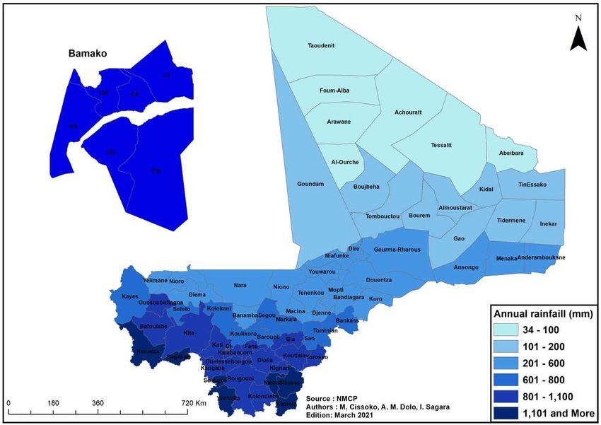
Figure 6

Map of average annual rainfall from 2017 to 2019 by health district in Mali.
Figure 7

Percentage of population outside at 5-km radius of a health facility in Mali 2019.
Figure 8

Malaria prevalence map of children aged 6-59 months according to DHS VI, Mali 2018.
Figure 9

Map of mortality of children under 5 years old from DHS 2018 survey in Mali.
Figure 10

Malaria vector distribution map, 2010 - 2019. The sector diagrams show the presence of the different
species.
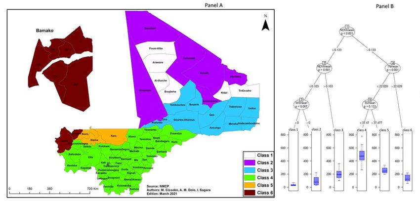
Figure 11

Map distribution of resistance of Anopheles gambiae s.l., a major malaria vector to different insecticides
from 2010 to 2019 in Mali. Red dots show the presence of insecticide resistance in the health district,
yellow dots show moderate sensitivity (below 90%) and green dots show a high sensitivity of major
vectors to insecticide.

Figure 12

Environmental supervised classi cation of malaria in Mali (CART). Class 1: Very low vegetation and no
surface water; Class 2: Very low vegetation around oases or wadis; Class 3: Low vegetation around the
northern part of the Niger River; Class 4: higher vegetation index, low night and day temperatures (
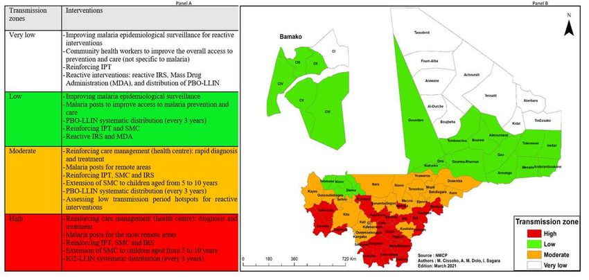
Figure 13

Malaria transmission zones in Mali according to adjusted incidence. Panel A: eligible interventions
according to strata and information on insecticide resistance in Mali; Panel B: Transmission zone map.
IRS: Indoor Residual Spraying; IPT: Intermittent Preventive Treatment for Pregnant Women; LLIN: Long-
Lasting Insecticide Impregnated Mosquito Net; IG2-LLIN: 2nd Generation of Long-Lasting Insecticide
Impregnated Mosquito Net; PBO-LLIN: Long-Lasting Insecticide Impregnated Mosquito Net with Piperonyl
Butoxide; SMC: Seasonal malaria Chemoprevention for children under 5; MDA: mass drug administration
(Figure 13).
Vous pouvez aussi lire