Abstract Volume 7th Swiss Geoscience Meeting - Neuchâtel, 20th - 21st November 2009
←
→
Transcription du contenu de la page
Si votre navigateur ne rend pas la page correctement, lisez s'il vous plaît le contenu de la page ci-dessous
Abstract Volume
7th Swiss Geoscience Meeting
Neuchâtel, 20th – 21st November 2009

1. Water across (scientific) boundaries
10
1. Water across (scientific) boundaries
Symposium 1: Water across (scientific) boundaries
Eduard Hoehn, Adrian Jakob, Ronald Kozel, Urs Mäder, Bruno Schädler, Mario Schirmer
Swiss Hydrological Commission CHy, Swiss Society for Hydrogeology SGH, Swiss Society
for Hydrology and Limnology SGHL, Rock-Water Interaction Group, Uni Bern, Eawag
Swiss Federal Institute of Aquatic Science and Technology
1.1 Alaoui A., Weingartner R.: Caractérisation hydrodynamique des principaux types de sol
1.2 Alt-Epping P., Waber H.N., Diamond L.W.: Insights from coupled thermal-hydraulic-chemical modelling of geochemi-
cal processes in carbonate and silicate-dominated reservoirs within deep geothermal systems
1.3 Babic D., Jenni R., Zwahlen F.: Transfer of solutes under forested watersheds
1.4 Badoux V., Perrochet P.: Well-head capture zones delineation in transient flow conditions: the use of equivalent stea-
dy-state approximations
1.5 Bonalumi M., Anselmetti F., Kägi R., Müller B., Wüest A.: Particles in reservoir waters affected by pump storage opera-
tions
1.6 Chèvre N., Guignard C., Bader H.P., Scheidegger R., Rossi L.: Sustainable management of urban water: substance flow
analysis as a tool
1.7 de Haller A., Tarantola A., Mazurek M., Spangenberg J.: Calcite-celestite veins and related past fluid flow through the
Mesozoic sedimentary cover at Oftringen, near Olten
1.8 Diem S., Vogt T., Hoehn E.: Spatial characterization of hydraulic conductivity of the Thurtal-aquifer at the test site
Widen
1.9 Dominik J., Vignati D.A.L.: Metal partitioning in aquatic systems: from interdisciplinary research to environmental
practice.
1.10 Driesner T. Coumou D., Weis Ph.: How water properties control the behaviour of continental and seafloor hydrother-
mal systems
1.11 Ducommun R., Zwahlen F.: Tracer tests in urbanised sites: a tool for a better characterisation of groundwater vulne-
rability in urban areas
1.12 Ewen T., Rinderer M., Bosshard Th., Seibert J.: A spectral analysis of rainfall-runoff variability for select Swiss catch-
ments
1.13 Germann P.: Gravity-driven Poiseuille-flow in the lithosphere
1.14 Glenz D., Renard Ph., Perrochet P., Alcolea A., Vogel A. : A synthesis of available data to analyze the interaction between
the Rhône River and its alluvial aquifer
1.15 Gremaud V., Goldscheider N.: Impacts climatiques sur la recharge d’un système karstique englacé, Tsanfleuron-
Sanetsch, Alpes suisses
1.16 Guédron S., Vignati D.A.L., Dominik J.: Partitioning of total mercury and methylmercury between colloids and true
solution in overlying and interstitial waters (Lake Geneva).
1.17 Hindshaw R., Reynolds B., Wiederhold J., Kretzschmar R., Bourdon B.: Trends in streamwater chemistry at the Damma
glacier, Switzerland
1.18 Huggenberger P.: Processes at and across the interface: Lessons lerned from river groundwater interactions under
different hydrologic conditions
1.19 Hunkeler D., Abe Y., Aravena R., Parker B., Cherry J.: The fate of organic contaminants at the groundwater - surface
water interface
1.20 Huxol St., Hoehn E., Surbeck H., Kipfer R.: Thoron as a possible marker tracing surface water / groundwater interac-
tion
1.21 Imfeld G., Nijenhuis I., Nikolausz M., Richnow H.H.: Variability of in situ biodegradation of chlorinated ethenes in a
constructed wetland (Nexans Award Laureate 2009)
1.22 Jaeger E.B., Lorenz R., Seneviratne S.I.: Role of land-atmosphere interactions for climate extremes and trends
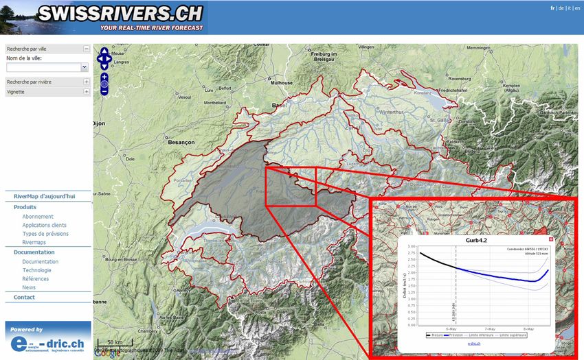
1.23 Jordan F., Philiponna C., Heller Ph.: Swissrivers.ch – Online river forecast prediction
1.24 Köplin N., Viviroli D., Weingartner R.: The influence of climate change on the water balance of mesoscale catchments
in Switzerland
1.25 Laigre L., Arnaud-Fassetta G., Reynard E.: Palaeoenvironmental mapping of the Swiss Rhone river
1.26 Lüthi M.: Storage and release of water and chemical species in glaciers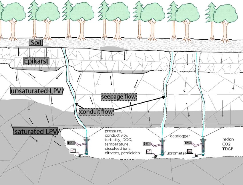
1.27   Marzocchi R., Pera S.: Groundwater and tunneling: implementation of a geochemical monitoring network in the                              11
       southern Switzerland

                                                                                                                                   Symposium 1: Water across (scientific) boundaries
1.28   MBock P., Loizeau J.-L.: Dynamics of colloid concentrations in a small river related to hydrological conditions and land
       use
1.29   Molnar P., Perona P., Burlando P.: Water disturbance as the organizer of riparian vegetation
1.30   Nitsche M., Badoux A., Turiwski J.M., Rickenmann D.: Calculating bedload transport rates in Swiss mountain streams
       using new roughness approaches
1.31   Niwa N., Rossi L., Chèvre N.: Pollution des eaux: la santé est-elle un levier pour mettre en place une gestion intégrée
       à l’echelle du basin versant?
1.32   Preisig G., Perrochet P.: Effective stress and fracture permeability in regional groundwater flow: numerical compari-
       son of analytical formulas
1.33   Rickenmann D.: Debris flows, landslides, and sediment transport in mountain catchments
1.34   Schill E., Abdelfettah Y., Altwegg P., Baillieux P.: Characterisation of geothermal reservoirs using 3D geological model-
       ling and gravity
1.35   Schnegg P.-A.: Field Fluorometer for Simultaneous Detection of 3 Colourless Tracers
1.36   Schwank M., Völksch I., Mätzler Ch., Stähli M.: Recent Research on the Remote Retrieval of Soil Moisture from Space
       with Microwave Radiometry
1.37   Sinreich M., v. Lützenkirchen V., Matousek F., Kozel R.: Groundwater Resources in Switzerland
1.38   Steinmann M., Pourret O.: The role of the colloidal pool for transport and fractionation of the rare earth elements in
       stream water
1.39   Tonolla M.: Microbial communities in the steep gradients of the meromictic lake Cadagno
1.40   Vennemann T., Fontana D., Paychere S., Ambadiang P., Piffarerio R., Favre L.: Dissolved inorganic carbon and its stable
       isotope composition as a tracer of geo-, bio-, and anthropogenic sources of carbon
1.41   Vogt T., Schneider P., Schirmer M., Cirpka O.A.: High-resolution temperature measurements at the river – groundwater
       interface: Quantification of seepage rates using fiber-optic Distributed Temperature Sensing
1.42   von Fumetti S., Gusich V., Nagel P.: Natural springs - the living passage between groundwater and surface water
1.43   Waber N.H.: Porewater as an archive of the palaeo-hydrogeology during the Holocene and Pleistocene
1.44   Wanner Ch., Schenker F., Eggenberger U.: In-situ Remediation of Polluted Groundwater: A Transdisciplinary
       Approach
1.45   Weis Ph., Driesner Th., Coumou D., Heinrich Ch.A.: On the physical hydrology of hydrothermal systems at mid-ocean
       ridges
1.46   Wüest A., Jarc L., Pasche N., Schmid M: One lake, two countries and a lot of methane - the concept for a viable extrac-
       tion of an unusual resource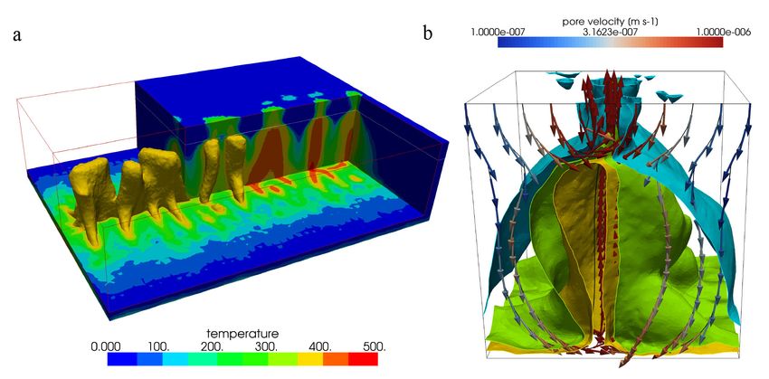
12
                                                    1.1
Symposium 1: Water across (scientific) boundaries

                                                    Caractérisation hydrodynamique des principaux types de sol
                                                    A. Alaoui & R. Weingartner

                                                    Groupe d’hydrologie, université de Berne, Hallerstrasse 12, 3012 Berne, Suisse
                                                    (alaoui@giub.unibe.ch)

                                                    La caractérisation hydrodynamique des principaux types de sol suisses n’est pas encore appréhendée. Elle dépend non seu-
                                                    lement du type du sol et de ses propriétés physiques mais surtout de sa structure fonctionnelle. L’aspect hydrodynamique
                                                    du sol n’est abordé que par un angle théorique ou numérique. Dans cette perspective, nous avons oeuvré pour mettre au
                                                    point une méthode robuste et fiable pour estimer quantitativement le flux à travers la zone non saturée et définir le risque
                                                    lié au type d’écoulement (Alaoui et al., 2003).
                                                    Le but de cette étude est la caractérisation hydrodynamique des principaux types de sol à potentiel agricole pour l’estimation
                                                    du flux d’eau transitant vers les eaux souterraines  permettant de procéder à une évaluation de leur degré de vulnérabili-
                                                    té.
                                                    La méthode utilisée dans cette étude est jugée robuste pour deux principales raisons: i) les mesures de la teneur à partir
                                                    desquelles le modèle MACRO (Jarvis, 1994) a été calibré sont très précises (intervalle de temps de mesure varie entre 1 et 5
                                                    minutes) et très denses (effectuées le long du profile du sol tous les 10 cm) et ii) le modèle utilisé est basé sur les principes
                                                    physiques du sol. De ce fait, les calculs de simulation sont fiables et peuvent être extrapolés à d’autres sols similaires (de
                                                    même type et même texture).
                                                    Les sols étudiés présentent un risque de pollution certain en cas d’application de pesticides ou herbicides quand ils sont
                                                    humides ou très humides comme c’est le cas des sols bruns et sols bruns acides.
                                                    Les sols bruns lessivés peuvent présenter ce risque en état sec et humide.
                                                    Quant aux sols à gley, ils présentent un risque de pollution relatif s’ils sont secs. Le risque augmente avec l’humidité. Quand
                                                    ces sols sont sur des nappes phréatiques fluctuantes, les eaux souterraines peuvent être contaminées par ruissellement vers
                                                    les rivières si le sol est en pente ou par percolation verticale vers l’eau de la nappe qui remonte rapidement en surface dans
                                                    le cas d’une plaine.
                                                    Ces résultats montrent en général que les sols ne présentent pas de risque majeur quand ils sont très secs. Le cas échéant,
                                                    les pesticides et herbicides pourraient être appliquées durant ces périodes pour autant que ces sols ne subissent pas d’averses
                                                    durant les jours qui suivent cette application.
                                                    Il est urgent d’établir une carte pédologique au niveau suisse qui tiendra compte du type de sol, de sa texture et du risque
                                                    de pollution qu’il présente en cas d’utilisation d’herbicides ou de pesticides. Cette carte servira aux pratiquants dans les
                                                    domaines du sol et de l’hydrologie. La présente étude est en faite à la base de cette cartographie et devra s’étendre aux sols
                                                    agricoles de culture différente. L’impact de la culture sur la structure du sol devrait être alors évalué

                                                    REFERENCES
                                                    Alaoui, A, Germann, P, Jarvis, N, Acutis, M., 2003. Dual-porosity and Kinematic Wave Approaches to assess the degree of
                                                        preferential flow in an unsaturated soil. Hydrol Sciences J. 48(3):455–472
                                                    Jarvis, N., 1994. The MACRO model Version 3.1 – Technical description and sample simulations. Reports and Dissertations
                                                        no. 19, Department of Soil Science, Swedish University of Agricultural Sciences, Uppsala, Sweden, 51 pp

                                                    1.2
                                                    Insights from coupled thermal-hydraulic-chemical modelling of geoche-
                                                    mical processes in carbonate and silicate-dominated reservoirs within
                                                    deep geothermal systems
                                                    Alt-Epping Peter, Waber H. Niklaus  & Diamond, Larryn W.

                                                    Institute of Geological Sciences, Rock–Water Interaction Group, University of Bern, Baltzerstrasse 1-3, CH-3012 Bern (alt-epping@geo.unibe.
                                                    ch)

                                                    We use coupled thermal-hydraulic-chemical models patterned after the geothermal systems at Bad Blumau, Austria, and
                                                    Basel, Switzerland to track the fate of fluids that originate from a carbonate and a silicate-dominated geothermal reservoir,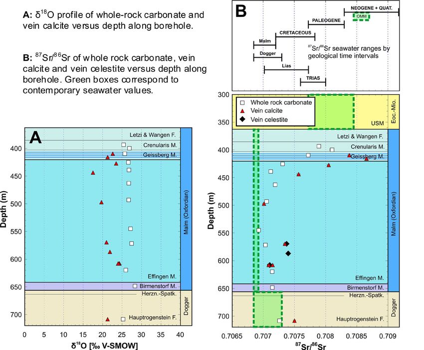
13
respectively, on their passage through the geothermal system. We use numerical simulations to explore 1) geochemical

                                                                                                                                       Symposium 1: Water across (scientific) boundaries
conditions in the undisturbed reservoir, 2) chemical and hydrological implications of reinjecting the used fluid into the
reservoir, 3) mineral scaling and the rate at which it occurs and 4) borehole corrosion and geochemical fingerprints indica-
ting incipient corrosion.

The composition of the fluid in the reservoir is buffered by the mineralogy of the aquifer rock at local temperature and
pressure conditions. Changes in pressure and conductive temperature during ascent and descent of the fluid induce
changes in mineral solubilities. Oversaturated minerals may cause scaling within the borehole. The precipitation of mineral
phases in the borehole is primarily dictated by the composition of the reservoir fluid. The distribution of minerals is a func-
tion of the flow and reaction rates. Mineral scaling within the borehole changes the fluid composition and may gradually
clog the borehole, thereby obstructing fluid flow. Because different minerals exhibit different solubilities as a function of
temperature, the mineral assemblages that precipitate in the production well are distinct from those in the injection well.
For instance, if the fluid in the reservoir is saturated in silica, then the prograde solubility behaviour of silica favours its
precipitation in the production well. Conversely, carbonate minerals tend to precipitate in the injection well owing to their
retrograde solubility behaviour. However, calculating the distribution of mineral phases is complicated by the fact that the
precipitation of some minerals is kinetically controlled, such that they may continue to precipitate far into the injection
well (e.g. amorphous silica)

Any modification of the fluid composition caused by mineral precipitation along the fluid’s pathway means that the rein-
jected fluid is no longer in equilibrium with the reservoir rock. Consequently, rock-water interaction and fluid mixing at
the base of the injection well drive chemical reactions that cause changes in porosity and permeability of the reservoir rock,
potentially compromising the efficiency of the geothermal system.

One concern during geothermal energy production is that of chemical corrosion of the borehole casing. For a range of
"what-if" scenarios we explore the effect of corrosion on the fluid composition and on mineral precipitation to identify
chemical fingerprints that could be used as corrosion indicators. Once suitable indicators are identified, incipient corrosion
could be detected early on during regular chemical monitoring. Corrosion of the casing is typically associated with the re-
lease of Fe and H2 into the circulating fluid. However, the implications of this release depend on the local chemical condi-
tions where corrosion occurs. For instance, elevated H2 in the fluid is a corrosion indicator only if it is not involved in sub-
sequent redox reactions. Similarly, low H2 concentrations do not rule out possible corrosion.

In general, the interpretation of a fluid or a mineral sample requires the understanding of chemical processes that occur
along the flowpath throughout the geothermal system. If direct observations are not possible, then this understanding can
only be achieved through numerical simulations that integrate and couple fluid flow, heat transport and chemical reac-
tions within one theoretical framework. Our simulations demonstrate that these models are useful for quantifying the
impact and minimizing the risk that chemical reactions may have on the productivity and sustainability of a geothermal
system.

1.3
Transfer of solutes under forested watersheds
Babić Domagoj*, Jenni Robert**, Zwahlen François*

*Centre of Hydrogeology and Geothermics (CHYN), Institute of Geology and Hydrogeology, University of Neuchâtel, Rue Emile-Argand 11,
2009 Neuchâtel, Switzerland
**Bureau Nouvelle Forêt sàrl, Rte de la Fonderie 8c, 1700 Fribourg, Switzerland

The ALPEAU project aims to strengthen the protecting role of forests when it comes to sustainable water resource manage-
ment and quality. Thus, several forested watersheds were chosen. The Gorges de l'Areuse watershed is located over the Swiss
Jura mountains karstik system, whereas the Jorat forest and the Mont Gibloux are situated on the Swiss Plateau, mainly
characterized  by sandstone formations.

The main goal of this study is to assess the fate of contaminants, such as nitrates and pesticides, on their way down from
the forest soil, which physico-chemical features are strongly linked to phytosociological combinations, through the unsatu-
rated and saturated zone down to the system outlet.

In karstic areas, it is important to discriminate between water coming from the soil reservoir, the epikarst (interface be-
tween soil and karst), the low permeability volumes (the rock volume between the epikarst and the system outlet) and the
14
                                                    freshly infiltrated rainwater. To do so, gases produced in the soil and dissolved in rainwater will be used. A combined radon,
Symposium 1: Water across (scientific) boundaries

                                                    CO2 and TDGP (total dissolved gas pressure) measurements will be carried out in a water adduction tunnel at the Gorges de
                                                    l'Areuse test site. Conductivity, temperature, turbidity, DOC (dissolved organic carbon), nitrogen and carbon isotopic compo-
                                                    sition and dissolved ions will also be part of the survey (Figure 1). Additional artificial tracing experiments will allow to get
                                                    insight into the travel time, the storage location and the degradation kinetic of dissolved compounds.

                                                    Even though the Mont Gibloux test site is set on top of a sandy aquifer, the same method will be applied, if travel times are
                                                    proved to be under a week. Indeed, radon decays with a half live of about 4 days, whereas CO2 reacts with carbonate on its
                                                    way down to the saturated zone.

                                                    The main focus on the Jorat forest test site is the environmental fate of cypermethrin, a synthetic insecticide used in timber
                                                    treatment, oil products used in forest management and their metabolites.
                                                    First of all, it is essential to understand the hydrogeological behaviour of the watershed. Thus, a classical physico-chemical
                                                    follow-up will be established at some chosen water harnessing, completed with comparative tracer tests. Then, wooden piles
                                                    will be set on treatment sites, treated with cypermethrin (within the range of legal concentrations) and spring water
                                                    watched over. The experiment will occur under artificial steady state conditions and during heavy rain events, as it is as-
                                                    sumed to cause significant infiltration into the aquifer.

                                                    Figure 1. Schematic view of the Gorges de l'Areuse test site (modfied after Savoy L. 2007)

                                                    REFERENCES
                                                    Perrin, J. 2003: A conceptual model of flow and transport in a karst aquifer based on spatial and temporal variations of
                                                       natural tracers, Phd thesis, University of Neuchâtel, Switzerland, 227 pages.
                                                    Savoy, L. 2007: Use of natural and artificial reactive tracers to investigate the transfer of solutes in karst systems, Phd thesis,
                                                       University of Neuchâtel, Switzeland, 194 pages.
                                                    Surbeck, H. 2003: Radon and CO2 as natural tracers in Karst Systems, proceedings of ICGG7 (2003), 33-33.
                                                    Subeck, H. 2005: Dissolved gases as natural tracers in karst hydrogeology; radon and beyond, proceedings of
                                                       Multidisciplinary Approach to Karstwater Protection strategy, Unesco Course, Budapest, Hungary.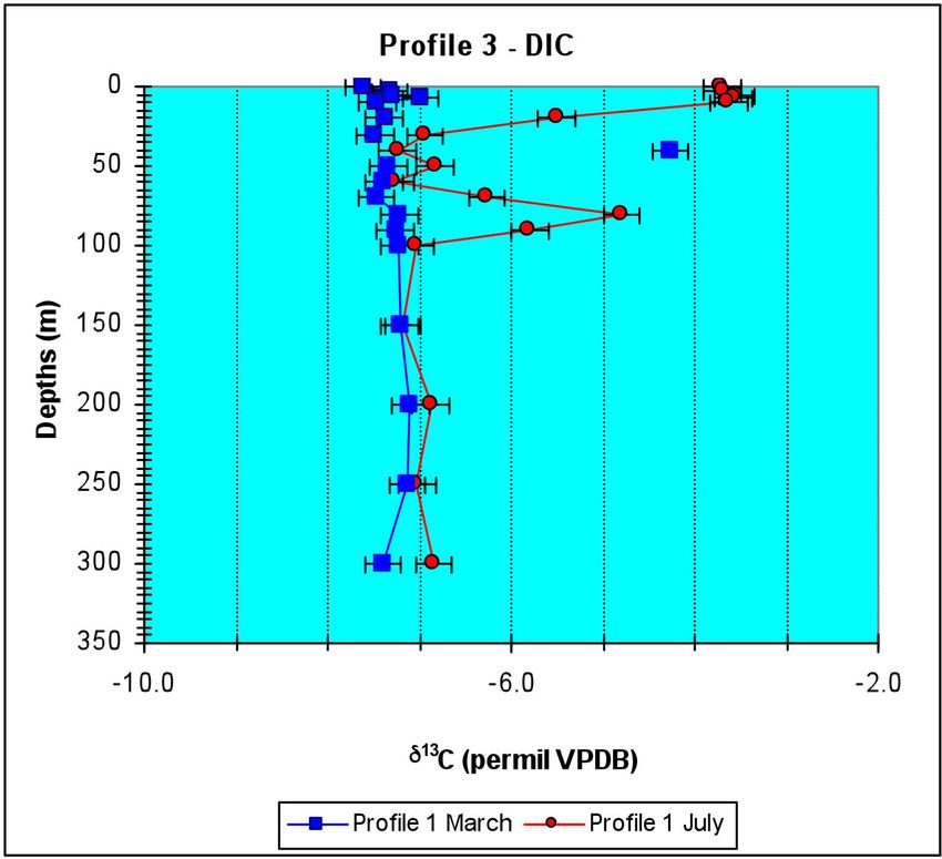
15
1.4

                                                                                                                                  Symposium 1: Water across (scientific) boundaries
Well-head capture zones delineation in transient flow conditions: the use
of equivalent steady-state approximations

Badoux Vincent* & Perrochet Pierre**

*AF-Colenco Ltd. Täfernstrasse, 26, CH-5405 Baden (Vincent.badoux@af-consult.com)
**Centre of Hydrogeology and Geothermics, Rue Emile-Argand 11, CH-2000 Neuchâtel (Pierre.perrochet@unine.ch)

The delineation of well-head protection areas S1, S2 and S3 as well as contribution zones  Zu aims to prevent groundwater
resources from instantaneous and perennial pollutions. Due to the stress they induce on the land use, these so-called protec-
tion schemes cause socio-economic impacts, that becomes non negligible in high-density population area, such as the Swiss
Plateau. Therefore the delineation of such protection schemes must be done with care in order to guaranty the protection
of the resource on the one hand, while minimizing the overestimation of their size on the other hand.

Aquifers are natural systems that vary with space and time. Such variability will directly influence the way contaminant
migrates through the aquifer and indirectly the design of the protection schemes. In practice, characterizing the resource
by integrating this variability requires much more effort than using a simple homogeneous medium with steady-state flow
conditions. Consequently the delineation of protection schemes is often done using low water steady-state flow conditions,
assuming this constitutes a safer approach. However, by applying this simplified methodology, the size of the protection
schemes is overestimated and the related socio-economic impacts enhanced.

A new methodology has been developed to identify flow conditions where steady-state approximation is justified or where
this approximation should be avoided (Badoux 2007). The ratio between the mean transit time and the fluctuation period
appears to be a good criterion to distinguish between these two cases. When this ratio is smaller than 0.5, the size of the
protection schemes can be rigorously obtained using high and low water flow conditions. When this ratio is big enough - the
exact number is site specific - the protection schemes can be approximated by mean steady-state flow conditions. In between,
protection schemes cannot be obtained by any steady-state flow conditions, except if some transport parameters are adapted
in an appropriate way.

This methodology has been applied to the Seeland aquifer in Canton Bern.

REFERENCES
Badoux, V. 2007. Analyse des processus advectifs-dispersifs en milieux poreux sous contraintes hydrologiques périodiques.
   Implications pour la protection des captages d’eaux souterraines. PhD Thesis, CHYN, Univ. Neuchâtel, 293 p.

1.5
Particles in reservoir waters affected by pump storage operations
Bonalumi Matteo*, Anselmetti Flavio*, Kägi Ralf**, Müller Beat*** & Wüest Alfred***

* Eawag, Swiss Federal Institute of Aquatic Science and Technology, Surface Waters – Research and Management, CH–8600 Dübendorf
(matteo.bonalumi@eawag.ch)
** Eawag, Urban Water Management, CH–8600 Dübendorf
*** Eawag, Surface Waters – Research and Management, CH–6047 Kastanienbaum

Pumped storage hydroelectricity is used to even out the daily and weekly fluctuations in energy consumption by pumping
water to a higher altitude reservoir during low-peak periods, using the excess base-load capacity from coal and nuclear sour-
ces. This project investigates the effect of this pump storage operations on particle characteristics in the water column and
on resulting sedimentation processes.

Grimselsee (1908 m) and Oberaarsee (2303 m), two reservoirs located in the Bernese Alps, are connected since 1980 by a pump
storage unit which exchanges an annual amount of water amounting to several times the volume of the reservoirs. The im-
pact of initial damming was studied recently for downstream areas and in the reservoirs themselves. The partially glaciated
16
                                                    catchments feeding the reservoirs lead to an enormous inflow of inorganic particles during snowmelt in spring, resulting
Symposium 1: Water across (scientific) boundaries

                                                    in high turbidity in the reservoirs. Compared to pre-dam conditions, reservoirs retain particles of larger grain size which
                                                    were previously released to downstream areas (Anselmetti et al., 2007). In addition, it was demonstrated that the shift of
                                                    runoff from summer to winter affects the light regime and, consequently, the primary production in Lake Brienz (Finger et
                                                    al. 2007; Jaun et al. 2007).

                                                    In order to understand the effect of the increasing pump storage operations on water turbidity and on particle size, water
                                                    sampling campaigns were performed seasonally in both reservoirs as well as in the power station connecting them. Turbidity
                                                    seems to correlate strongly with weather conditions and catchment characteristics in summer and with pump storage acti-
                                                    vity in winter. In summer, Grimselsee was found to be more turbid than Oberaarsee, which has a stronger thermal stratifi-
                                                    cation and whose catchment is less glaciated. In winter, Grimselsee and Oberaarsee show similar conditions. However, tur-
                                                    bidity was higher close to the in-/outlets, where both reservoirs are continuously exchanging water.

                                                    Hydraulic machines such as turbines cause shear stress and turbulence, which are known to induce flocculation of particles
                                                    (Blaser & Boller, 1998; Serra et al., 2008). In order to investigate whether this effect occurs in the Grimsel reservoirs, water
                                                    samples were taken upstream and downstream of the turbines during pump storage and power production regimes. To date,
                                                    SEM image analyses and particle-counter analyses did not discover any aggregation effect, suggesting that the there is not
                                                    significant change in particle characteristics from turbine passages.

                                                    REFERENCES
                                                    Anselmetti, F. S., Bühler, R., Finger, D., Girardclos, A., Lancini, A., Rellstab, C. & Sturm, M. 2007: Effects of Alpine hydropower
                                                       dams on particle transport and lacustrine sedimentation. Aquatic Sciences, 69, 179-198.
                                                    Finger, D., Bossard, P., Schmid, M., Jaun, L., Müller, B., Steiner, D., Schäffer, E., Zeh, M. & Wüest, A. 2007: Effects of alpine
                                                       hydropower operations on primary production in a downstream lake. Aquatic Sciences, 69, 240-256.
                                                    Jaun, L., Finger, D., Zeh, M., Schurter, M. & Wüest, A. 2007: Effects of upstream hydropower operation and oligotrophication
                                                       on the light-regime of a turbid peri-alpine lake. Aquatic Sciences, 69, 212-226.
                                                    Boller, M. & Blaser, S. 1998: Particles under stress. Wat. Sci. Tech., 37 (10), 9-29.
                                                    Serra, T., Colomer, J. & Logan, B. E. 2008: Efficiency of different shear devices on flocculation. Water Research, 42 (4-5), 1113-
                                                       1121

                                                    1.6
                                                    Sustainable management of urban water: substance flow analysis as a tool
                                                    Chèvre Nathalie*, Guignard Cécile*, Bader Hans-Peter**, Scheidegger Ruth**,  & Rossi Luca***.

                                                    * IMG - Faculté des Géosciences et de l’Environnement, Université de Lausanne, CH-1015 Lausanne (nathalie.chevre@unil.ch)
                                                    **Eawag, CH-8600 Dübendorf
                                                    *** IIE-ECOL, ENAC, EPFL, CH-1015 Lausanne

                                                    Pollutants released by cities into water are of more and more concern as they are suspected of inducing long-term effects on
                                                    both aquatic organisms and humans (for example, hormonally active substances). The substances found in the urban water
                                                    cycle have different sources in the urban area and a different fate in the cycle. For example, the pollutants emitted from
                                                    traffic get to surface water during rain events often without any treatment, and are partially removed from the water cycle
                                                    by sedimentation; pharmaceuticals resulting from human medical treatments get to surface water mainly through waste-
                                                    water treatment plants, where they are partly taken out from water. The residual concentrations can re-enter the cycle
                                                    through drinking water. It is therefore crucial to study the behavior of xenobiotics in the urban water cycle and to get flexi-
                                                    ble tools for urban water management.

                                                    The substance flow analysis (SFA), an extension of the classical material flow analysis originally developed by Baccini &
                                                    Brunner, has recently been proposed as instrument for phosphorous management in urban water system.  SFA is based on
                                                    the principle of mass balance: a substance enters a closed system and may be transported or transformed in the system and
                                                    may also leave the system.
                                                    To be used as management tool, SFA should be coupled with environmental quality criteria. These values express the maxi-
                                                    mum concentration, which is tolerable for a given substance in order to protect both human and the environment. Having
                                                    this limit in mind, one can detect the most problematic flows and take action to diminish them.
                                                    In our study, we tested the application of SFA for a large number of classes of xenobiotics, i.e. heavy metals, pharmaceuticals,
                                                    biocides and cosmetics, to evaluate its use for urban water management. We chose the city of Lausanne as case study as many
                                                    data were available, on both the sewer system and the water quality.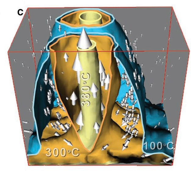
17
The city of Lausanne, which is around 42 km with 130’000 inhabitants. Lausanne is near lake Geneva and its effluents
                                                     2

                                                                                                                                           Symposium 1: Water across (scientific) boundaries
mainly reach this ecosystem, which is a recreational area as well as a source of drinking water for the city. The system itself
is described in Figure 1 and illustrated for copper. We considered thirteen inputs of this heavy metal in the water system:
drinking water (I1), roofs (I2) and houses sides (I3) runoff, road runoff collecting car brakes (I4), tires abrasion (I5), motor oil
residues (I6) and dry deposition (I12), particles from catenaries from trolleybuses (I7), inputs through trains, i.e. particles from
catenaries (I8), brakes (I9) and wheels (I10) abrasion, input through boats (I11) and rainwater (I13). Transfer coefficients were es-
timated based on measurement or hypotheses. For copper, the water quality criterion was given by the Swiss legislation and
the sediment quality criterion proposed elsewhere.

The SFA of copper showed that the city of Lausanne releases about 600Kg and 900Kg per year of this heavy metal in respec-
tively the water and the sediments of lake Geneva. These estimations were validated by measurements of copper in the Lake
near Lausanne. In the sediments, the continuous enrichment induces high concentrations of this heavy metal, which are
above the recommended quality criterion. By using the SFA, we could identify that copper mainly reaches the Lake with
stormwater, i.e without being removed by any treatment. The major sources are the catenaries of the trolleybuses and the
roofs runoff. A reduction of the contamination of the water system would therefore include actions at this level (for example
the treatment of the roofs runoff). SFA was also applied to biocides and pharmaceuticals with interesting results (not shown
here).

Figure 1: Description of the urbain drainage system of Lausanne and application to copper. The “I” flows stay for “Input”. The “k” flows
for the transfer coefficients.

REFERENCES
Baccini P., & Brunner P., 1991: Metabolism of the anthroposphere, Springer, Berlin, Germany.
Chèvre N., Guignard C., Rossi L., Pfeifer H.-R., Bader H.-P., and Scheidegger R. Substance flow analysis as a tool for urban
   water management: the case of copper in Lausanne, Switzerland, Submitted.
MacDonald D., Ingersoll C., and Berger T., 2000: Development and evaluation of consensus-based sediment quality
   quidelines for freshwater ecosystems, Archives of Environmental Contamination and Toxicology, 39, 20-31.

1.7
Calcite-celestite veins and related past fluid flow through the Mesozoic
sedimentary cover at Oftringen, near Olten

de Haller Antoine*, Tarantola Alexandre*, Mazurek Martin* & Spangenberg Jorge**

*RWI, Institute of Geological Sciences, University of Bern, Baltzerstr. 1-3, CH-3012 Bern (DeHaller@geo.unibe.ch)
**Institute of Mineralogy and Geochemistry, University of Lausanne, Building Anthropole, CH-1015 Lausanne

The study is based on core samples from the recently drilled, 719 m deep borehole at Oftringen (near Olten), located in the
northwestern Molasse basin, at 1.5 km  from the frontal thrust of the Folded Jura (Waber, 2008). Veins of calcite (±celestite,
pyrite) occur in the whole Malm sequence (up to 8 veins/m), including the more clay-rich Effingen Member. To date, such an
intensity of veining in the Effingen Member has not been found in other deep boreholes located in the Molasse basin. Most
of the veins are related to tectonic activity, but clay-filled karst structures are recognized in the upper Geissberg Member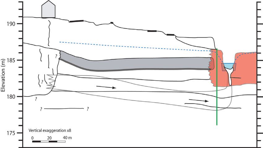
18
                                                    limestone, and a few structures probably related to the diagenetic processes are documented in the Effingen Member. Fluid
Symposium 1: Water across (scientific) boundaries

                                                    inclusions show average salinities between 3.3 and 4.4 wt% eq. NaCl in celestite and 2.7 wt% eq. NaCl in calcite. Average ho-
                                                    mogenization temperatures in calcite fluctuate between 56 and 68 °C, with a broad increase with depth and no correlation
                                                    with salinity.

                                                    Malm whole-rock carbonates have δ18O values fluctuating within a narrow range, probably determined by equilibrium with
                                                    seawater (Fig. 1A). Their 87Sr/86Sr ratios follow a well-defined depth profile with minimum values in the middle part of the
                                                    Effingen Member, fitting with Oxfordian seawater (McArthur et al., 2001; Fig. 1B). No correlation is observed between 87Sr/86Sr
                                                    and clay content, and values higher than contemporary seawater might be related to the incorporation of radiogenic detrital
                                                    carbonate.

                                                    The δ18O values of vein calcite are systematically lower than the corresponding whole rock carbonate (Fig. 1A), consistent
                                                    with precipitation from seawater at 50 - 70 °C. The δ34S and δ18O values of vein celestite follow a bacterial reduction trend
                                                    pointing to Miocene seawater sulfate. Two vein pyrites gave negative δ34S values consistent with bacterial sulfate reduction.
                                                    Calcite and celestite of diagenetic origin have 87Sr/86Sr ratios that are indistinguishable from the corresponding whole rock
                                                    carbonate fraction. In contrast, the 87Sr/86Sr ratios of epigenetic vein calcite and celestite show a systematic enrichment in
                                                    radiogenic Sr compared to the corresponding whole-rock carbonate and require an external Sr source. Only Burdigalian
                                                    seawater, at the time of Upper Marine Molasse (OMM) deposition, had an 87Sr/86Sr ratio high enough to explain the highest
                                                    value obtained (Fig. 1B).

                                                    The rocks of the Malm-Dogger sequence were not pervasively affected by fluids post-dating burial diagenesis, and the influ-
                                                    ence of such fluids was restricted to open structures. The Molasse basin subsided in the Burdigalian (Kuhlemann and Kempf,
                                                    2002; Mazurek et al., 2006), and the veins might record tectonic activity related to this process. Calcite and celestite precipi-
                                                    tated from descending seawater due to heating to 50-70°C, while precipitation of pyrite resulted from bacterial reduction of
                                                    part of the seawater sulfate.

                                                    Figure 1. Oxygen and strontium isotopic data.
19
REFERENCES
Symposium 1: Water across (scientific) boundaries
Kuhlemann J., & Kempf, O. 2002: Post-Eocene evolution of the North Alpine Foreland Basin and its response to Alpine
tectonics. Sed. Geol. 152, 45-78.
McArthur, J.M., Howarth, R.J., & Bailey, T.R. 2001: Strontium isotope stratigraphy: LOWESS Version 3: Best fit to the marine
Sr-isotope curve 0-509 Ma and accompanying look-up table for deriving numerical age. J. Geol. 109, 155-170.
Mazurek, M., Hurford, A. J. & Leu, W. 2006: Unravelling the multi-stage burial history of the Swiss Molasse Basin: Integration
of apatite fission track, vitrinite reflectance and biomarker isomerisation analysis. Basin Res. 18, 27-50.
Waber, N., ed. 2008: Borehole Oftringen: Mineralogy, Porosimetry, Geochemistry, Pore Water Chemistry. NAGRA
Arbeitsbericht NAB-08-18, Nagra, Wettingen, Switzerland.
1.8
Spatial characterization of hydraulic conductivity of the Thurtal-aquifer
at the test site Widen
Diem Samuel, Vogt Tobias, Hoehn Eduard
Eawag, Swiss Federal Institute of Aquatic Science and Technology, Überlandstrasse 133, CH-8600 Dübendorf (samuel.diem@eawag.ch)
For many hydrogeological and modeling problems on a scale of the order of 10-100 m, an assessment of the spatial distribu-
tion of hydraulic conductivity (h.c.) is of great importance. This is one of the tasks of the ReCorD project (Restored Corridor
Dynamics) of CCES (Competence Center Environment and Sustainability of the ETH Domain). This project aims at understan-
ding, how river restoration measures affect river - river corridor - groundwater systems in hydrologic and ecologic terms. The
river Thur and the alluvial gravel-and-sand aquifer of the perialpine Thur valley flood plain were chosen for field investiga-
tions. In this aquifer, the distribution of h.c. at the required scale has not yet been investigated. Thus, the aim of this Master
Thesis is to characterize the hydrogeology of the aquifer at a test site in the central part of the valley (Widen, Felben-Well-
hausen/TG), which extends to about 10x20 m (aquifer thickness, 7 m), by using different methods on different scales. Work
included logging of core drillings, sieving of the gravel samples (decimeter scale) and the conduction and analysis of a pum-
ping test (decameter scale), flowmeter logs and slug tests (meter scale), with appropriate methods. Except for the slug tests
(14 wells), four fully penetrating wells with piezometers of a diameter of 4.5” were used. The analysis of these tests resulted
in values of h.c.
The sieve analyses (vertical intervals of samples: 0.5 m) were performed with the core material of the four wells. The values of
h.c. calculated after Casati (1959) led to small absolute values and a narrow distribution (n=53, µ=-2.73 m/s, σ2=0.01; where
µ=log10 geometric mean, σ2=log10 variance). The small variability can be explained by the approach of the formula of Casati
(1959), taking into account five grain size fractions and assuming absence of the secondary porosity of the material. The
small absolute values originate from the calibration of the formula to a specific aquifer. Sieve analyses are well suited for a
rough estimate of h.c. of perialpine alluvial gravel-aquifers, with an accuracy of a factor of about 2.
The pumping test (pumping well is one of the four wells, head observations in nine additional wells) involves a large aquifer
volume. As for all pumping tests, the resulting value of h.c. (here calculated after Neuman (1972, in Kruseman & De Ridder
1991)) is biased by highly conductive zones and corresponds to the upper limit of the spectrum of the natural variability
(µ=-1.83 m/s). This value is adequate for large scale investigations.
Flowmeter measurements were carried out at intervals of 0.25 m in the four 4.5”-piezometers. As for all flowmeter tests, an
analysis with the method of Javandel & Witherspoon (1969, in Molz 1989) resulted in vertical profiles of relative values of
h.c. The relative values can be calibrated to absolute values: Here they are calibrated relative to the mean h.c. of the pumping
test, which integrates a large aquifer volume (total of n=29, µ=-1.83 m/s, σ2=0.14; calculated for an average of 0.5 m intervals).
The bias of the result of the pumping test is thus transferred to the results of the flowmeter measurements. The relative
profile of h.c. should rather be calibrated with the result of tests that involve only a small aquifer volume, e.g. slug tests in
fully penetrating wells, which are hard to realize in a highly conductive aquifer. So flowmeter logs are the adequate method,
if the relative vertical distribution of h.c. is of primary importance.
Slug tests. For detailed information about the spatial distribution of h.c. in the order of 10-100 m, which is needed in the
ReCorD project for the modeling of groundwater flow, solute and heat transport at small scales, pneumatic multi-level slug
tests (with a system of double packers) were applied in 117 intervals of 0.5 m length of 14 piezometers (analyzed after Bouwer
and Rice 1979, Springer and Gelhar 1991, in Butler 1998). These experiments resulted in the following distribution of h.c.:
n=117, µ=-2.38 m/s, σ2=0.11.
A statistical evaluation of the values of h.c. from the above methods showed that the results can not be compared. Thus, the
choice of the method to assess the distribution of h.c. has to be done according to the problem and the required level of20
detail. The slug tests resulted in the best absolute and relative representation of the distribution of h.c., compared to the
Symposium 1: Water across (scientific) boundaries
other three methods: The absolute values of h.c. do not have to be calibrated with the result of a different method, the values
of h.c. are accurate and cover most of the natural range of h.c. A statistical comparison of sieve analyses of the Widen test
site with those of the whole Thur valley has shown that the distribution of d10, d50 and d60 grain size fractions are similar in
the western part of Thur valley. Probably, the distribution of h.c. assessed for the Widen test site can also be used for the
western part of the valley, as this site seems to belong to the same facies. To decrease the work load required for slug tests
and to increase the level of detail in h.c. assessments, I recommend a combination of hydraulic testing with high resolution
geophysics and the use of tracers. The development of geophysical and tracer methods are an integral part of the ReCorD
project.
REFERENCES
Butler, J. J. JR. 1998: The design, performance, and analysis of slug tests. Lewis Publishers.
Casati, A. 1959: Die Durchlässigkeit kiesiger Böden. Monatsbulletin SVGW 6, 120-126.
Kruseman, G. P. & De Ridder, N. A. 1991: Analysis and evaluation of pumping test data. ILRI Publication 47, Second Edition.
Molz, F. J. 1989: The impeller meter for measuring aquifer permeability variations: Evaluation and comparison with other
tests. Water Resour. Res. 25 (7), 1677-1683.
1.9
Metal partitioning in aquatic systems: from interdisciplinary research to
environmental practice.
Dominik Janusz* & Vignati Davide A.L. **
* Institut F.-A. Forel, Section de sciences de la Terre et d’environnement, Université de Genève, CP 416, 1290 Versoix – janusz.dominik@
unige.ch ,
** CNR-IRSA, Via del Mulino 19, 20047 Brugherio (MB), Italy – vignati@irsa.cnr.it
Knowledge of partitioning of metals is fundamental for understanding their transport and their availability to aquatic or-
ganisms. Furthermore, a considerable fraction of metals in rivers, lakes and coastal ocean may be of anthropogenic origin
with concentrations approaching the levels considered harmful for aquatic ecosystems. Measuring and, when possible, pre-
dicting metal partitioning therefore becomes essential for environmental risk assessment and associated management
plans.
Current European and Swiss legislations fix environmental quality standards (EQSs) on metals for the filterable phase; defi-
ned as the metal fraction passing through the pores of a 0.45µm filter. A large fraction of “filterable” metals is actually asso-
ciated with small-size colloids and thus is not truly in solution. Unlike metals in true solution, colloidal metals can be remo-
ved from the water column via coagulation and/or aggregation and sedimentation processes. Moreover, metals bound to
colloids are not available to some organisms (e.g., algae), but might be available for others (e.g., zooplankton). These discre-
pancies between fundamental knowledge and current environmental practices raise two major questions: a) Is it possible,
and useful, to determine metal partitioning in monitoring programs? b) How can the knowledge of metal partitioning bet-
ween colloidal and truly dissolved phases be used in environmental assessment?
The published data indicate that metals of low solubility in oxic conditions (e.g., Cr(III), Fe, Mn, Ti, Pb) are predominantly
associated with colloids, while metals preferentially forming anionic complexes occur mostly in true solution (e.g., Cr(VI),
Mo, U, V). Partitioning of elements occurring as divalent cations (e.g., Cu, Zn, Cd, Ni, Hg ) depends largely on physico-chemi-
cal conditions of ambient water and on the quantity and quality of colloids.
For the priority elements mentioned in European legislation, the literature data indicate that, in general, Ni and Cd have
lower affinity for colloids than Pb and Hg (fig. 1). Note however that a part of the observed variability is caused by persisting
technical limitations; i.e. tangential flow filtration (the most widely used technique to separate colloidal and truly dissolved
fraction in partitioning studies) not being standardized and prone to artifacts. In such situation, measurement of metal
partitioning between colloids and true solution in routine monitoring programs remains unlikely and probably not advisa-
ble. Nevertheless, inferring the percentage of truly dissolved fraction from the total filterable fraction has proven to be
feasible for some elements (Vignati et al. 2005). Such information can be used to refine models on elements’ environmental
fate and also provide a more realistic evaluation of toxicity at primary producer level; which is highly relevant to the assess-
ment of ecological risk. Indeed, algal bioassays carried out in the presence of organic colloids, demonstrated decreasing to-
xicity with increasing fraction of metals bound to colloids (Koukal et al. 2003, 2007).21
Symposium 1: Water across (scientific) boundaries
Fig. 1. Percentage of toxic metals associated with the colloidal fraction according to published data from freshwater and estuarine or coa-
stal systems (compiled in Vignati et al. 2009). Bars represent the range between the means of the lower and the upper limits in each study.
REFERENCES
Koukal, B., Guéguen, C., Pardos, M. & Dominik, J. 2003: Influence of humic substances on the toxic effects of cadmium and
zinc to the green alga Psedokirchneriella subcapitata. Chemosphere, 53, 953–961.
Koukal, B., Rossé, P., Reinhardt, A., Ferrari, B., Wilkinson, K. J., Loizeau, J.-L. & Dominik, J. 2007: Effect of Pseudokirchneriella
subcapitata (Chlorophyceae) exudates on metal toxicity and colloid aggregation. Water Res., 41, 63-70.
Vignati D.A.L., Camusso M. & Dominik J. 2005: Estimation of the truly dissolved concentrations of Cd, Cu, Ni, and Zn in
contrasting aquatic environments with a simple empirical model. Ecological Modelling 184, 125–139.
Vignati D.A.L., Valsecchi, S., Polesello, S., Patrolecco, L, & Dominik, J. 2009: Environmental realism and WFD
implementation: chemical and ecological relevance of particle-colloid-true solution partitioning of pollutants for
surface water monitoring. Trends in Analytical Chemistry, 28, 159-169.
1.10
How water properties control the behaviour of continental and seafloor
hydrothermal systems
Driesner Thomas*, Coumou Dingeman** & Weis Philipp*
*Institute of Isotope Geochemistry and Mineral Resources, ETH Zentrum, CH-8092 Zürich (thomas.driesner@erdw.ethz.ch)
**Potsdam Institute for Climate Impact Research, Telegrafenberg A62, D-14412 Potsdam
The flow patterns and thermal evolution in hydrothermal systems are of prime interest to a variety of basic and applied
geoscience disciplines ranging from biogeoscience research on life in extreme environments through economic geology to
geothermal energy exploration. Due to the extreme temperature-pressure conditions as well as the difficult access to many
of these systems (e.g. those at mid-ocean ridges), insight has mostly been gained from numerical simulation.22
In the case of continental hydrothermal systems heated by magmatic intrusions, numerical simulation has shown that the
Symposium 1: Water across (scientific) boundaries
system-scale permeability structure is a prime order control on how much the convecting hydrothermal fluid may be heated.
This is a result of the different rates with which convection (with the fluid flow rate primarily being controlled by permea-
bility) transports heat away from the source and conduction (in the essentially impermeable hot magmatic source) delivers
heat to the fluid (Hayba&Ingebritsen, 1997; Driesner&Geiger, 2007). On the other hand, fluid properties such as the position
of the water boiling curve in temperature-pressure space are a major control on the style of hydrothermal fluid flow in the
upflow zone.
For mid-ocean ridge hydrothermal systems, recent developments in numerical simulation techniques have revealed that the
temperature-pressure-composition dependence of fluid properties such as viscosity, density, and heat capacity is a first order
control on hydrothermal system behaviour. For example, by heating water from ambient temperature to to 200°C, viscosity
drops by one order of magnitude. This increases the mobility of water by the same amount as a one order of magnitude in-
crease in permeability. Hence, hot water can essentially “by itself” create corridors of high hydraulic conductivity in environ-
ments of otherwise homogenous permeability. As a result, strong self-organization effects may occur, the prime example
being the recent prediction of pipe-like hydrothermal plumes underlying “black smoker” hydrothermal systems and being
surrounded by narrow cylindrical zones of intense, warm recharge (Coumou et al., 2008). Current research focuses on the
question to what degree these effects interfere with those resulting from the permeability structure of the crust (see Weis
et al., this volume).
Figure 1. Thermal structure of the hydrothermal plume underlying a mid-ocean ridge black smoker field. A hot central upflow zone with
temperatures up to 380°C is surrounded by a narrow recharge zone with temperatures between 100 and 200°C. From Coumou et al. (2008)
For oceanic systems with a homogenous permeability distribution, it can be shown that there is a strong interplay of fluid
properties and permeability that determines the system’s temperature as well as its ability to convect the incoming heat.
Numerical simulations, verified by semi-analytical calculations, show that typical black smoker temperatures can only be
achieved when permeability is LESS than about 3x10-14 m2. At higher permeabilities, the temperatures are lower since fluid
flow rates are too fast to allow stronger heating near the magmatic heat source. Below this permeability, fluid properties
limit the maximum temperature of the system to ca. 400°C. Similarly, for typical heat flow rates at the bottom of the system,
not all incoming heat can be convected away, and magma eruptions to the seafloor may potentially be the only way to ba-
lance the total heat input.
To what degree the influence of fluid properties may play a role in the formation of ore deposits or in the operation of geo-
thermal systems is subject to ongoing research.
REFERENCES
Coumou, D., Driesner, T. & Heinrich, C. A. (2008) The structure and dynamics of mid-ocean ridge hydrothermal systems.
Science 321, 1825-1828
Driesner, T. and Geiger, S. (2007) Numerical simulation of multiphase fluid flow in hydrothermal systems. In Fluid-Fluid
Interactions (A. Liebscher and C.A. Heinrich, eds.) Reviews in Mineralogy and Geochmistry 65, pp. 187-212
Hayba, D. O., and Ingebritsen, S. E. (1997) Multiphase groundwater flow near cooling plutons. Journal of Geophysical
Research 102, 12,235–12,252.23
1.11
Symposium 1: Water across (scientific) boundaries
Tracer tests in urbanised sites: a tool for a better characterisation of
groundwater vulnerability in urban areas
Romain Ducommun*, François Zwahlen*
*Centre d’Hydrogéologie et de Géothermie (CHYN), Université de Neuchâtel, Emile-Argand 11, CH-2000 Neuchâtel, romain.ducommun@
unine.ch
Vulnerability assessments and mapping methods (Vrba & Zaporozec 1994) are principally designed for natural areas.
However, in urban zones, the groundwater recharge is strongly modified, due mainly to sealing of surface and/or presence
of subsurface water mains and sewer pipes, which can contribute to recharge, or inversely act as drains for water in saturated
and unsaturated zones (Lerner 2002; Thomas & Tellam 2006). As recharge can be considered as a key parameter for vulnera-
bility evaluation (e.g., Aller, Bennett et al. 1987), urban processes which modify groundwater recharge have to be included
in any vulnerability assessment of given urban groundwater resources.
In this perspective, multi-tracer tests were carried out at local scale in two urban test sites in Switzerland: Colombier and
Neuchâtel. The Colombier test site is located in a low urbanised area, on quaternary glacial sediments forming the Plateau
de Planeyse, where a small shallow aquifer is present in the silty formations. The Neuchâtel test site, at the shore of Lake
Neuchâtel (Maladière area), is located in a high urbanised area, on highly heterogeneous anthropogenous backfill material
and quaternary glacio-lacustrine sediments. The artificial conservative tracers (uranine, sulforhodamine B, duasyne and
naphtionate) were injected in sealed and unsealed surfaces, or directly in subsurface rainwater pipes. In both test sites, tracer
recovery was monitored in underlying urban aquifers (wells and drainage collectors), and in the downstream part of pipes
where the tracer injections were performed.
The recovery results in Colombier and Neuchâtel (example of breakthrough curve in figure 1) pointed out dual role of pipes
on recharge (increasing or decreasing recharge), an increase in recharge due to runoff concentration at the boundaries of
sealed surfaces, and an increase in recharge due to the presence of artificial backfill materials in the uppermost part of the
unsaturated zone. Not surprisingly, increased rates of tracer recovery during wet hydrological periods were observed during
the performed tests.
Effects of these various parameters on recharge were further interpreted from a local urban-adapted groundwater vulnera-
bility perspective. Consequently, key factors like the presence of underground pipes (in association with pipe parameters:
material, age, hydraulic head, etc), or the local modifications of hydraulic conductivity of soil/subsoil formations by human
activity, have to be integrated in urban groundwater vulnerability assessments and mapping methods.
Figure 1. Breakthrough curve for sulforhodamine B (sulfo B) and time-series for electrical conductiity (EC), turbidity, dischar-
ge, and water temperature at the Colombier drainage outlet (summer 2007). The major rainfall event (A) and its noticeable
related tracer response are indicated.24
REFERENCES
Symposium 1: Water across (scientific) boundaries
Aller, Bennett, et al. 1987: DRASTIC: a standardized system for evaluating groundwater pollution potential using
hydrogeological settings. U.S. Environmental Protection Agency (EPA), Ada, Oklahoma, USA.
Lerner 2002: Identifying and quantifying urban recharge: a review. Hydrogeology Journal 10(1): 143.
Thomas and Tellam 2006: Modelling of recharge and pollutant fluxes to urban groundwaters. Science of the Total
Environment 360(1-3): 158.
Vrba and Zaporozec, Eds. 1994: Guidebook on Mapping Groundwater Vulnerability. International Contributions to
Hydrogeology, vol. 16. Hannover, Heinz Heise GmbH.
1.12
A spectral analysis of rainfall-runoff variability for select Swiss catch-
ments
Tracy Ewen*,**, Michael Rinderer*, Thomas Bosshard**, and Jan Seibert*
**Institute for Atmospheric and Climate Science, ETH Zurich, Universitätstr. 16, 8092 Zurich.
*Department of Geography, University of Zurich, Winterthurerstr. 190, 8057 Zurich, (tracy.ewen@geo.uzh.ch)
Time series analysis can provide useful insight into the complex relationships between variables of interest. In particular,
analysis of precipitation and runoff for a particular hydrological catchment allows the physical complexity of the system to
be better understood, both spatially and temporally. The Fourier transform is often used to analyse the frequency domain
of time series, however, due to the non-stationarity of climatological and hydrological variables, wavelets have been intro-
duced to analyse the spectral properties over time by transforming a time series into two-dimensional time-frequency
space.
Wavelets have been used to understand the temporal and spatial variability in complex hydrological systems through an
analysis of rainfall and runoff (for e.g., Labat et al., 2000) and to characterise remote watersheds based on runoff data only
(Gaucherel, 2002). Cross-wavelet analysis between variables gives further insight into the temporal variability of the relation-
ship (Grinsted et al., 2004) and insight into physical processes governing the system, in particular, the basin response to
rainfall, which may help to classify catchments.
Here, we use wavelets to analyse daily precipitation and runoff time series from the Rietholzbach and the Töss catchments
in Switzerland to better understand temporal relationships, with a focus on extremes during the past 30 years. We further
investigate the spatial relationship between precipitation and runoff and quantify the precipitation contribution from dif-
ferent meteorological stations to total runoff for each catchment. We also discuss the minimal time-scales needed to ade-
quately represent the physical relationships between rainfall and runoff (and hence the climatological signal), which could
be applied, for e.g., in order to constrain hydrological impact studies (Bosshard et al., 2009).
REFERENCES
Bosshard, T. Ewen, S. Kotlarski, and C. Schär, 2009: The annual cycle of the climate change signal - An improved method for
use in impact studies, Geophysical Research Abstracts, Vol. 11, EGU2009-7095.
Gaucherel, C., 2002: Use of wavelet transform for temporal characterization of remote watersheds, J. Hydrol., 269, 101-121.
Grinsted, A., S. Jevrejeva, J. Moore, 2004: Application of the cross wavelet transform and wavelet coherence to geophysical
time series, Nonlinear Proc. Geophys., 11: 561-566.
Labat, D., R. Ababou, A. Mangin, 2000: Rainfall-runoff relations for karstic springs. Part I: convolution and spectral analysis,
J. Hydrol., 238, 123-148.Vous pouvez aussi lire