Global Change: Assessment and Adaptation to Mediterranean Region Water Scarcity - Deuxième Workshop - The CHAAMS Project
←
→
Transcription du contenu de la page
Si votre navigateur ne rend pas la page correctement, lisez s'il vous plaît le contenu de la page ci-dessous
Deuxième Workshop

Global Change: Assessment and Adaptation
to Mediterranean Region Water Scarcity

               Recueil des résumés

          27 et 28 janvier 2020 - Marrakech, Maroc
2ème workshop du projet ERANETMED-CHAAMS, Marrakech, 27 et 28 janvier 2020
Présentation résumée du projet ERANET-MED
« Global Change: Assessment and Adaptation to Mediterranean Region Water Scarcity »
Ces dernières années, plusieurs organisations internationales et une riche activité scientifique ont
souligné l’enjeu stratégique que constituait l’eau pour le développement économique de la région
méditerranéenne. Cette région se caractérise par un déclin sévère et continu des ressources, tant
en termes de quantité que de qualité, associé à une augmentation de la demande, dont 70 à 80%
concernent les activités agricoles. Cette situation est exacerbée sur la rive sud de la Méditerranée,
où la spécificité du climat (sécheresses fréquentes) associée aux changements induits par les
activités humaines augmente le risque de crises. Dans ce contexte hydrique difficile, l'équilibre
séculaire fragile entre ressources et usages est donc aujourd'hui menacé par les bouleversements
profonds et rapides de l'agriculture dans les régions semi-arides du côté sud. Les territoires
agricoles, qui consomment et produisent de l'eau agricole et de l'eau potable pour satisfaire des
besoins multiples, se caractérisent par une concurrence entre différents acteurs dont
l'interdépendance résulte, entre autres, du cycle hydrologique. Ces problèmes sont communs à la
plupart des pays méditerranéens, où les problèmes de durabilité, de concurrence et
d’interdépendance se déclinent de différentes manières.
En réponse à ces questions sociétales, le projet vise à mettre en œuvre une approche systémique
du fonctionnement éco-hydrologique des agro-systèmes en relation avec les réservoirs physiques
(capacités de stockage et de renouvellement) et les acteurs (opérateurs et gestionnaires). Les
échelles spatiales ciblées sont les échelles des processus de prise de décision allant de la parcelle
pour la planification de l'eau d'irrigation, l'échelle intermédiaire du bassin versant pour la
planification du bassin versant à l'ensemble de la région méditerranéenne. L'objectif de notre
projet est double: (1) contribuer à une meilleure compréhension de l'évolution des ressources
sous changement global et évaluer les trajectoires d'eau les plus probables et (2) proposer
plusieurs solutions innovantes à moyen et long terme pour rationaliser utilisation de l'eau agricole
dans la région sur la base des outils de décision existants développés par le consortium. La
question de la gestion des ressources en eau et du cycle hydrologique associé est abordée selon la
dualité de consommation (infiltration et stockage dans la zone racinaire) et de production
(percolation des aquifères et des eaux de ruissellement vers des réservoirs artificiels), en tenant
compte des interactions entre les zones en amont (enneigement, agriculture pluviale) et en aval
(plaines irriguées).
Quatre bassins du sud de la Méditerranée sont considérés: les bassins du Tensift (Maroc), du
Merguellil (Tunisie), du Lebna (Tunisie) et du Litani (Liban). Les quatre bassins se caractérisent par
les interactions mentionnées ci-dessus entre les zones en amont et en aval et entre les cultures
pluviales et irriguées. Le consortium est composé de 7 partenaires scientifiques avec le soutien de
7 parties prenantes. La mise en œuvre du projet sur les quatre agrosystèmes implique la mise en
réseau de structures pérennes sur les rives nord et sud de la Méditerranée, à savoir deux
laboratoires mixtes internationaux de l’Institut de Recherche pour le Développement avec ses
partenaires (TREMA, NAÏLA), le laboratoire international associé du CNRS (O-LIFE) et quatre
systèmes d'observation, dont trois sont impliqués dans des réseaux nationaux et / ou
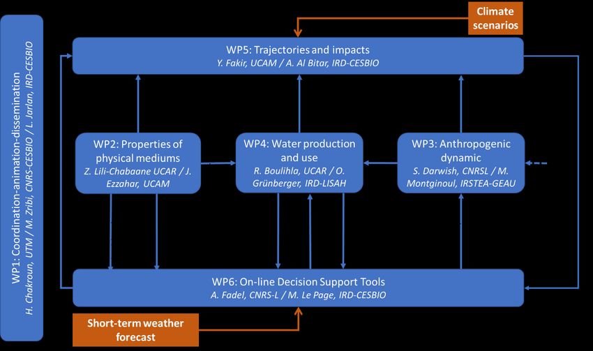
internationaux (Merguellil (réseau JECAM), Lebna (réseau national français OMERE), Tensift2ème workshop du projet ERANETMED-CHAAMS, Marrakech, 27 et 28 janvier 2020 (réseau national IRD, réseau JECAM) , Litani (O-LIFE). Cette mise en réseau induit une politique de mobilité forte entre les structures, pour échanger et partager des connaissances sur l'observation, la modélisation et l'analyse intégrée. Cette politique de mobilité sera principalement mise en œuvre pour les jeunes chercheurs afin de renforcer la dynamique méditerranéenne que ces jeunes chercheurs animeront dans les décennies à venir. Figure 1: Logique du projet CHAAMS Mise en oeuvre Afin de mettre en œuvre ce projet collectif et pluridisciplinaire, cinq actions clés qui constituent également les Work Package sont ciblées tandis que le WP1 est dédié à la gestion de projet et à la diffusion des résultats (Fig. 1). Le WP2 vise à caractériser les variabilités spatio-temporelles des propriétés biophysiques des agrosystèmes et le développement des indicateurs de stress hydrique et de sécheresse des cultures utilisés ultérieurement dans le WP6. Le WP3 est dédié à la compréhension des facteurs socio-économiques à la base de la prise de décision des agriculteurs et de la gouvernance des ressources en eau. Le WP4 vise à analyser les aspects de la qualité de l'eau et à identifier la production d'eau et à utiliser les modèles des principaux systèmes agricoles (modernes vs traditionnels, intensifs vs extensifs, plantes annuelles…) coexistant avec les changements observés au WP2 et WP3. Le WP5 vise à projeter les impacts de l'utilisation de l'eau agricole sur les réservoirs d'eau de surface et souterraine grâce à des outils de modélisation intégrés déjà mis en œuvre sur les sites d'étude ciblés et les scénarios climatiques et socio- économiques (WP3). Le WP6 vise à renforcer et à diffuser aux gestionnaires les solutions pré- opérationnelles existantes développées au sein du consortium pour rationaliser l'utilisation de l'eau agricole. Partenariat Le consortium CHAAMS est composé de 7 partenaires de France (CESBIO, G-EAU et LISAH), du Liban (CNRSL), du Maroc (UCAM) et de Tunisie (UCAR et UTM). Ces partenaires ont été soigneusement
2ème workshop du projet ERANETMED-CHAAMS, Marrakech, 27 et 28 janvier 2020

sélectionnés en fonction de l'expertise spécifique qu'ils apportent au projet. Dans la répartition des
ressources, une tentative a été faite pour garantir un apport équilibré de chaque partenaire au projet. Seuls
les partenaires qui dirigent le projet (CESBIO et UTM) ont reçu un peu plus de ressources en raison de la
charge de travail supplémentaire liée à la coordination et à la gestion. Quatre grands domaines d’expertise
sont nécessaires pour mener à bien le projet. Tous les champs sont bien couverts par au moins trois
partenaires:

• Socio-économie (3 partenaires: G-EAU, UTM et CNRSL)

• Observation de la Terre et suivi agricole (4 partenaires: CESBIO, CNRSL, UCAR et UCAM)

• Modélisation hydrodynamique (4 partenaires: LISAH, UTM, UCAM et UCAR)

• Fonctionnement hydrologique des cultures (5 partenaires: CESBIO, LISAH, UCAR, UCAM
2ème workshop du projet ERANETMED-CHAAMS, Marrakech, 27 et 28 janvier 2020
Improving Evapotranspiration estimation by integrating surface soil moisture data
in TSEB model
Bouchra Ait Hssaine1, Olivier Merlin2, Jamal Ezzahar1,3, Salah Er-Raki1,4, Saïd Khabba1,5,
Abdelghani Chehbouni2,3
1
CRSA, Université Mohammed VI Polytechnique, Ben Guerir, Maroc
2
CESBIO, centre d’Etudes Spatiales de la BIOsphère, Toulouse, France
3
MTI-ENSA, University Cadi Ayyad, Safi, Maroc
4
LP2M2E-FSTM, University Cadi Ayyad, Marrakech, Maroc
5
University Cadi Ayyad, Marrakech, Maroc
A precise estimate of the evapotranspiration (ET) is fundamental for determining the crop water
needs and subsequently for optimizing water management practices and irrigation regimes. Re-
garding data availability over large areas and at multiple scales, remote sensing observations pro-
vide very relevant information to feed ET models.. Surface soil moisture (SM) and land surface
temperature (LST) are the essential components of the hydrological cycle, especially, for control-
ling soil evaporation and plant transpiration. The main goal of this work is to test a model of ET
based on a combination of LST and SM data. For this purpose, SM data are integrated into an en-
ergy balance model (TSEB-SM) already constrained by LST and that explicitly represents the fluxes
of soil and vegetation. TSEB-SM is derived from the TSEB formalism for the vegetation transpira-
tion and represents the soil evaporation using empirical parameters ( , ) of the relationship
between soil surface resistance ( ) and SM. For the vegetation cover fraction fc0.4, the model
calibration consists of inverting every 30-min. When fc>0.4, the calibration consists in estimat-
ing the Priestly Taylor coefficient (αPT) at the daily time scale. The procedure is applied over an
irrigated wheat field in the Tensift basin, central Morocco. The mean retrieved values of soil re-
sistance calculated for the entire study period are (6.06, 2). The calibrated daily αPT ranges be-
tween 0 and 1.9. The high value of αPT is mainly justified by the intense irrigation along the agricul-
tural season. Moreover, the ET simulated by the model fits well with observations. The obtained
correlation coefficient R2, root mean square RMSE, and mean bias error MBE are 0.75, 92 and 59
W/m2, respectively. Overall, the coupling of the soil resistance formulation with the TSEB formal-
ism improves the estimation of soil evaporation, and consequently, improves the partitioning of
ET. Analysis of the retrieved time series indicates that the daily αPT mainly follows the phenology
of winter wheat crop with a maximum value coincident with the full development of green bio-
mass and a minimum value reached at harvest.2ème workshop du projet ERANETMED-CHAAMS, Marrakech, 27 et 28 janvier 2020
Assessing soil moisture constraint on soil evaporation and plant transpiration
fractioning
Bouchra Ait Hssaine1, Olivier Merlin2, Jamal Ezzahar1,3, Salah Er-Raki1,4, Saïd Khabba1,5,
Abdelghani Chehbouni2,3
1
CRSA, Université Mohammed VI Polytechnique, Ben Guerir, Maroc
2
CESBIO, centre d’Etudes Spatiales de la BIOsphère, Toulouse, France
3
MTI-ENSA, University Cadi Ayyad, Safi, Maroc
4
LP2M2E-FSTM, University Cadi Ayyad, Marrakech, Maroc
5
University Cadi Ayyad, Marrakech, Maroc
Over semi-arid agricultural regions, detecting the crop water need at the onset of water stress is of
paramount importance for optimizing the use of irrigation water. Evapotranspiration (ET) is a cru-
cial component of the water cycle, it strongly impacts the water resource management, drought
monitoring, and climate. Remote sensing observations provide very relevant information to feed
ET models. In particular, the microwave-derived surface (0-5 cm) soil moisture (SM), which is the
main controlling factor of soil evaporation, the visible/near-infratred-derived vegetation cover
fraction (fc), which provides an essential structural constraint on the fractioning between vegeta-
tion transpiration and soil evaporation, and - thermal-derived land surface temperature (LST),
which is a signature of both available energy and evapotranspiration (ET) rate. The aim of this
work is to integrate those independent and complementary information on total ET within an en-
ergy balance model. As a state-of-the-art and commonly used model, we chose the TSEB model-
ling as a basis for developments. An innovative calibration procedure is proposed to retrieve the
main parameters of soil evaporation (soil resistance, rss) and plant transpiration (Priestly Taylor
coefficient, αPT) based on a threshold on fc. The procedure is applied over an irrigated wheat field
in the Tensift basin, central Morocco. Overall, the coupling of the soil resistance formulation with
the TSEB formalism improves the estimation of soil evaporation, and consequently, improves the
partitioning of ET. Analysis of the retrieved time series indicates that the daily αPT mainly follows
the phenology of winter wheat crop with a maximum value coincident with the full development
of green biomass and a minimum value reached at harvest. The temporal variations of αPT before
senescence are attributed to the dynamics of both the root zone soil moisture and the amount of
green biomass.2ème workshop du projet ERANETMED-CHAAMS, Marrakech, 27 et 28 janvier 2020
Evapotranspiration partition using the multiple energy balance version of the
ISBA-A-gs land surface model over two irrigated crops in a semi-arid Mediterrane-
an region (Marrakech, Morocco)
Ghizlane Aouade1, Lionel Jarlan2, Jamal Ezzahar3,4, Salah Er-raki5,4, Adrien Napoly6, Abdelfattah
Benkaddour1, Said Khabba7,4, Gilles Boulet2, Sébastien Garrigues8,9, Abdelghani Chehbouni2,4, and Aaron
Boone6
1Laboratoire des Géo-ressources/LMI TREMA, Faculté des Sciences et Techniques, Université Cadi Ayyad, Marrakech,
Maroc
2Centre d'Etudes Spatiales de la Biosphère (CESBIO)/IRD, Toulouse, France
3Equipe de Mathématiques et traitement de l'information (MTI), Ecole Nationale des Sciences Appliquées, Université
Cadi Ayyad, Safi, Maroc
4CRSA, Center of Remote Sensing Application, Mohammed VI Polytechnic University UM6P, Benguerir, Moroc
5LP2M2E, Faculté des Sciences et Techniques, Université Cadi Ayyad, Marrakech
6Centre National de Recherches Météorologiques (CNRM), Météo-France/CNRS, Toulouse, France
7LMME, Département de physique, Faculté des Sciences Semlalia, Université Cadi Ayyad, Marrakech, Maroc
8EMMAH, INRA, Université d'Avignon et des Pays de Vaucluse, Avignon, France
9Centre for Ecology and Hydrology (CEH), Wallingford, UK
The main objective of this work is to question the representation of the energy budget in surface–
vegetation–atmosphere transfer (SVAT) models for the prediction of the convective fluxes in the
case of irrigated crops with a complex structure (row) and under strong transient hydric regimes
due to irrigation. To this objective, the Interaction Soil–Biosphere–Atmosphere (ISBA-A-gs) based
on a composite energy budget (named hereafter ISBA-1P for 1 patch) is compared to the new mul-
tiple energy balance (MEB) version of ISBA using two representations of the canopy energy budg-
et: a coupled approach (ISBA-MEB) where the vegetation layer is located above the soil and a
patch representation corresponding to two-adjacent uncoupled source schemes (ISBA-2P for 2
patches). The evaluation is performed over a winter wheat field, taken as an example of homoge-
neous canopy and on a more complex open olive orchard. Continuous observations of evapotran-
spiration (ET) with Eddy covariance system, soil evaporation (E) and plant transpiration (Tr) with
Sapflow and isotopic methods were used to evaluate the three representations. A preliminary
sensitivity analyses showed a strong sensitivity to the parameters related to turbulence in the
canopy introduced in the new ISBA-MEB version. The ability of the single and dual-source configu-
ration to reproduce the composite soil-vegetation heat fluxes was very similar: the RMSE differ-
ences between ISBA-1P, -2P and -MEB did not exceed 10 W/m2 for the latent heat flux. These re-
sults showed that a composite energy balance on homogeneous covers is sufficient to reproduce
the total convective fluxes. By contrast, differences were highlighted on the partition of ET. In par-
ticular, the ISBA-2P version showed an over-estimation of soil evaporation of about 20 % because
of a direct exposition to incoming solar radiation and because there is no root extraction for the
bare soil patch with regards to –MEB and -1P representations. By contrast, the dual source config-
urations including both the uncoupled (ISBA-2P) and the coupled (ISBA-MEB) representations out-
performed the single source version (ISBA-1P) with slightly better results for ISBA-MEB in predict-
ing both total heat fluxes and evapotranspiration partition over the moderately open canopy of
the Olive orchard site. Concerning plant transpiration in particular, the coupled approach ISBA-
MEB provides better results than ISBA-1P and, to a lesser extent ISBA-2P with RMSEs of 1.60, 0.90,
0.70 mm/day and R2 of 0.43, 0.69 and 0.70 for ISBA-1P, -2P and MEB respectively. In addition, it is
shown that the acceptable predictions of composite convective fluxes by ISBA-2P for the Olive2ème workshop du projet ERANETMED-CHAAMS, Marrakech, 27 et 28 janvier 2020 orchard are obtained for the wrong reasons as neither of the two patches is in agreement with the observations because of a bad spatial distribution of the roots and of a lack of incoming radiation screening for the bare soil patch. This work shows that composite convection fluxes predicted by the SURFEX platform as well as partition of evapotranspiration in a highly transient regime due to irrigation is improved for moderately open tree canopies by the new coupled dual-source ISBA- MEB model. It also points out the need for further local scale evaluation on different crops of vari- ous geometry (more open rainfed or denser intensive olive orchard) to provide adequate parame- terization to global data base such as ECOCLIMAP-II in the view of a global application of the ISBA- MEB model.
2ème workshop du projet ERANETMED-CHAAMS, Marrakech, 27 et 28 janvier 2020

  Simple and spatialize approach to optimize irrigation water and wheat yield in
                              the semi-arid areas

                              Benabdallah S.1, Gharnouki I.1,2, Aouissi J.2

                        1
                         Centre de Recherches et des Technologies des Eaux – CERTE
                             2
                              Institut National Agronomique de Tunisie – INAT

The Merguellil catchment, located in central Tunisia, is characterized by a semi-arid climate. The
catchment extends on an area of about 1200 km² upstream El Houareb dam. Streamflow and ero-
sion modelling were carried by the Soil and Water Assessment Tool model.
This model requires a number of spatial and temporal inputs including the digital elevation model,
the soil map as well as the physical-chemical characteristics of each soil layer, the land use map,
and climatic data. The catchment witnessed many soil and water conservation works changing its
hillslopes.
A sensitivity analysis of the hydrological model to input data was carried to identify the needed
rainfall stations for modelling. The calibration of the model was made for theupper part of the
basin delimited by the hydrometric station of Haffouz over the 1992-2005 period using SWATCUP
based on the algorithm SUFI-II. The calibration allowed identifying the most sensitive parameters.
The model was then validated at the El Houareb dam based on the water level of the dam
converted into flows. The performance of the model is satisfactory and the Nash-Sutcliffe
Efficiency coefficient is 0.52. It was shown that the soil and water conservation Works (Counter
ridge) contributed to the retention of a large amount of sediment and reduced runoff within the
Merguellil basin.

Keywords: Modeling, Merguellil, SWAT, Calibration, Soil and Water Conservation Works.
2ème workshop du projet ERANETMED-CHAAMS, Marrakech, 27 et 28 janvier 2020
Impact des changements climatiques sur l’arboriculture fruitière dans la région de
Kairouan
Haïfa Benmoussa1, Jihène Ben Yahmed1, Mehdi Ben Mimoun1
1
Université de Carthage, Institut National Agronomique de Tunisie (INAT), Laboratoire LR17AGR01
Gestion intégrée des Ressources Naturelles : Télédétection, Analyse spatiale et Modélisation, Tunisie
Actuellement, la Tunisie est parmi les pays les plus vulnérables aux changements climatiques. La
région de Kairouan sera parmi les régions les plus touchées par le changement du climat dans le
futur et aura une baisse de pluviométrie de 2 à 4% et augmentation des températures entre 1.7 et
1.8 °C en 2050. Cette région aura une baisse accrue de pluviométrie de 15 à 20% en 2100 et une
augmentation considérable de températures entre 2.3 et 2.4 °C pour la même période. Les
hausses de températures entrainent un manque de froid et une consommation plus importante
en eau ce qui exerce une pression conséquente sur les ressources naturelles. Dans ce sens, il est
nécessaire d’évaluer l’impact des changements climatiques futurs ainsi que l’adaptation des
espèces fruitières dans la région de Kairouan. En effet, au cours de notre étude, nous avons réalisé
des projections des quantités de froid historiques et futures en utilisant 78 scénarios climatiques
pour le RCP4.5 et RCP8.5 et pour deux périodes 2041-2070 et 2071-2100 pour évaluer l'évolution
de la disponibilité du froid hivernal dans la région de Kairouan. L’évolution de l’accumulation du
froid au cours du temps et au passé entre 1980 et 2019 a été aussi suivie. Nos résultats ont
montré que durant les 40 dernières années, la région de Kairouan a subi des diminutions des
quantités de froid hivernales accumulées et devra encore perdre des quantités de froid dans le
futur qui seront plus sévères vers la fin du siècle. Ceci pourra avoir des conséquences graves sur le
secteur agricole en Kairouan et très peu d’espèces fruitières seront adaptées. Il limitera ainsi le
choix des espèces et variétés à planter et changera le patrimoine génétique, car certaines espèces
seront abandonnées et d’autres seront introduites. Des mesures d’adaptation et de mitigation aux
changements climatiques devront être alors adoptées. Une reconsidération des besoins en eau
devra être établi surtout pour des nouvelles espèces adaptées selon les changements futurs et
une prédiction de la disponibilité des quantités d’eau devra être réalisée.
Mots clés : Changements climatiques ; Kairouan ; Espèces fruitières ; Besoins en eau2ème workshop du projet ERANETMED-CHAAMS, Marrakech, 27 et 28 janvier 2020
Assessing the linkages between agricultural drought index derived from remote
sensing data and a Land Data Assimilation system and cereal production in Mo-
rocco
Elhoussaine Bouras1, 2, Lionel Jarlan2, Salah Er-Raki 1,3, Clement Albergel4, Riad Balaghi5, Saïd Khabba3,6
1
LP2M2E-FSTM, University Cadi Ayyad, Marrakech, Maroc
2
CESBIO, centre d’Etudes Spatiales de la BIOsphère, Toulouse, France
3
CRSA, Université Mohammed VI Polytechnique, Ben Guerir, Maroc
4
CNRM UMR 3589, Météo-France/CNRS, Toulouse, France
5
Institut National de Recherche Agronomique, Rabat, Morocco.
6
LMFE-FSSM, University Cadi Ayyad, Marrakech, Maroc
In Morocco, cereal production shows a high interannual variability due to uncertain rainfall and
recurrent drought periods that may occur at key phenological stages. In view of the importance of
this resource to the country’s economy, it is important to better characterize the impact of
drought strength and duration on yields in order to better anticipate production at the seasonal
scale. While meteorological drought is usually derived from precipitation anomalies, the
monitoring of agronomical drought may be more complex because of data availability issues. In
this study, drought is assessed through, on one hand, classical indices derived from remote
sensing data (Vegetation Condition Index -VCI-, Temperature Condition Index -TCI-, Vegetation
Health Index -VHI- and Soil water index SWI ) and on the other hand, the outputs of a land data
assimilation system (LDAS). The LDAS has been developed by the CNRM/Meteo-France and is
composed of the ISBA-A-gs land surface model forced by ERA-5 re-analysis constrained by LAI
product and a surface soil moisture derived from scatterometer data. LAI, Transpiration and soil
moisture at different depth are used. Correlation analysis was conducted to examine the
relationships between drought indices during the growing season and final yield, according to data
collection from 2000 to 2017. The results show that the correlation between drought indices
computed using remote sensing data are depend on phenological stage of development. A strong
correlation was found between VCI and cereal yield during heading stage for all provinces (R= 0.6
to 0.93). For TCI the relationship with cereal yield was found to be higher during development
stage (R= 0.61 to 0.82). Finally, for SWI the correlation was strong during sowing to emergence
stage for all province (R= 0.57 to 0.95) except Kenitra province which dominated by irrigated
cereal. On the other hand, the result of this study confirmed that drought influences on crop
production differently, depending on the development stage at the time of its occurrence.
Comparing the correlation between this indices and yield at monthly and phenological stage show
that the correlation at phenological stage was improved. In addition, the contribution of VCI and
TCI in to VHI was optimized. This optimization was established at phenological stage scale, with
using yield anomaly as independent drought index reference. The results show that during
growing season of cereal, at development stage the contribution of TCI in vegetation health was
found to be higher. By contrast, during heating stage the contribution of VCI was found to be
higher. Finally, outputs from the LDAS appeared very promising as strong correlation were
obtained with LAI assimilated in March (R=0.92), with transpiration from February until March
(R=0.85-0.9) and for soil moisture at the beginning of crop season (December R=0.86) during
emergence. Our current work is focused on the development of empirical models for early
forecasting cereal production at the provincial and national scales based on machine learning
approach.2ème workshop du projet ERANETMED-CHAAMS, Marrakech, 27 et 28 janvier 2020
Climate change and Mediterranean agriculture: Impacts on irrigated wheat
grain yield and irrigation requirements
Elhoussaine Bouras1, 2, Lionel Jarlan2, Saïd Khabba3,4, Salah Er-Raki1,4, Alain Dezetter5, Fathallah Sghir6,
Yves Tramblay5
1
LP2M2E-FSTM, University Cadi Ayyad, Marrakech, Maroc
2
CESBIO, centre d’Etudes Spatiales de la BIOsphère, Toulouse, France
3
LMFE-FSSM, University Cadi Ayyad, Marrakech, Maroc
4
CRSA, Université Mohammed VI Polytechnique, Ben Guerir, Maroc
5
HSM, Montpellier, France
6
Office Régional de Mise en Valeur Agricole du Haouz (ORMVAH), Marrakech, Maroc
The southern Mediterranean regions are likely to face drastic climate changes (CC). Agricultural
yields, particularly of cereals, could be severely affected, especially if significant changes occur at
the key phenological stages. In addition, while agriculture is expected to meet around 83% of
North African food demand by 2050, the increase in agricultural water requirements due to the
intensification of practices, the extension of arable land and the expected warming could
jeopardize the water supply of other key economic sectors. In this context, the present work aims
to quantify the impact of CC on the grain yields of irrigated cereals and their water requirements
in the Tensift-Haouz region of Morocco. The Med-CORDEX ensemble runs under scenarios RCP4.5
and RCP8.5 are first evaluated and disaggregated using the quantile-quantile approach. The
impact of CC on the duration of the main wheat phenological stages based on the degree-day
approach is then analysed by considering three typical sowing dates (early, around November
15th; intermediate, around December 15th; and late, around January, 15th). The results show that
the rise in air temperature causes a shortening of the development cycle of up to 50 days (around
30%). The impacts of rising temperature, increasing atmospheric CO2 concentration and changes
in precipitation on wheat yields are next evaluated, based on the AquaCrop model (previously
calibrated on several plots of winter wheat in the region of study), both with and without taking
into account the fertilizing effect of CO2. As expected, optimal wheat yields for all climate
scenarios and time horizons will decrease on the order of 7 to 30% depending on the sowing date,
if CO2 concentration rise is not considered. The results also show that the fertilizing effect of CO2
can counterbalance yield losses, since optimal yields could increase by 7% and 13% respectively at
mid-century for the RCP4.5 and RCP8.5 scenarios. Finally, water requirements are expected to
decrease by 13 to 42% depending on sowing date, scenario and horizon, mainly in response to the
shortening of the cycle. This decrease is associated with a change in temporal patterns, with the
requirement peak coming two months earlier than under current conditions. This study provides
some quantitative elements for agricultural practices adaptation, in particular concerning the
sowing date and also for water management in the south mediterranean region related to the
temporal patterns of the crop water needs.2ème workshop du projet ERANETMED-CHAAMS, Marrakech, 27 et 28 janvier 2020
Evaluation of the potential of Sentinel-1 and Sentinel-1 data for clay content
mapping
Safa Bousbih1,2, Mehrez Zribi1, Zohra Lili-Chabaane2, Nicolas Baghdadi3, Azza Gorrab1, and Nadhira Ben
Aissa2
1
CNRS, CESBIO, Toulouse, France (mehrez.zribi@cesbio.cnes.fr)
2
INAT, GREEN-TEAM, Tunis, Tunisia
3
UMR TETIS, Montpellier, France
Soil texture is a key parameter in agricultural processes and an important measure for agricultural
prediction, water cycle, filtering of pollutants and carbon storage. Besides, its estimation is
essential for agronomists, hydrologists, geologists and environmentalists and for modeling in these
application areas. Several studies have been based on understanding and modeling the biological,
physical and chemical processes in the soil. Regarding the texture of the soil, few researches
propose soil texture spatialization, and are generally based on ground measurements. Among
other things, field observations or laboratory analyzes are very expensive and are not very
representative. Indeed, the soil texture presents a strong heterogeneity even at the scale of a
field. It is then necessary to use precise and spatialized information on soils.
These methods are generally based on remote sensing data and particularly optical data to restore
soil component. However, these techniques are strongly affected by atmospheric conditions. This
constraint is not valid for Radar sensors (Radio Detection And Ranging). Radar data are mainly
sensitive to soil moisture and soil roughness, and has also been evaluated for its ability to perform
texture measurements.
The aim of this study is evaluate the potential of these techniques based on optical and radar data
for soil texture estimation. By its composition, its structure, its texture and its porosity, soil
moisture is strongly influenced by the soil nature. With the arrival of Sentinel-1 (S-1) and Sentinel-
2 (S-2) ESA spatial missions, data are acquired with high spatial and temporal resolution between
July and early December 2017, on a semi-arid area in central Tunisia. This study is therefore
conducted using S-2 SWIR (Short-Wave Infrared) bands (B11 and B12, most sensitive to clay) and
soil moisture products derived from radar data. And algorithms based on the support vector
machine (SVM) and random forest (RF) methods are proposed for the classification and mapping
of clay content.
In order to evaluate the approach and determine the adequate data (between optical and radar
data) allowing to precisely characterize the clay content, a cross-validation was used. The SWIR
bands lead to less satisfactory outcomes compared to soil moisture. With an overall accuracy of
approximately 65%, soil moisture achieved the best performance for estimating soil texture. The
results also showed that RF and SVM are robust classifiers for texture estimation despite the small
number of training data. However, RF displays greater accuracy and speed of simulation compared
to SVM.2ème workshop du projet ERANETMED-CHAAMS, Marrakech, 27 et 28 janvier 2020
Water productivity of cereals by SENTINEL-2 and LANDSAT-8 in Lebna watershed
(Cap Bon)
Chakroun H.1, Bouhlel S1.
1
University of Tunis El Manar, National Engineering School of TUNIS (ENIT), LR99ES19 Laboratory of Modelling in
Hydraulics and Environment (LMHE), Tunis, Tunisia
A good assessment and monitoring of water productivity (WP) is a crucial step to properly manage
agricultural water resources and ensure food security. This requires knowledge on the water
consumption of crops and on the crop production. The present study explores the contribution of
remote sensing in the estimation of cereals water productivity in the Lebna watershed (Cap-Bon).
The adopted methodology was based on the WATPRO model combining the Monteiths theoretical
framework for biomass evaluation and the energy balance for water consumption. A simplified
version of the model allows the assessment of WP from albedo and NDVI spatial variables in
combination with the extraterrestrial radiation and the air temperature. This version of the
WATPRO model was tested using time series images LANDSAT-8 and SENTINEL-2 images between
2015 and 2018.
At the plot level, results show close WP values derived from LANDSAT-8 (WPwheat = 0.364 Kg/m3
WPbarley = 0.408 Kg/m3) and from SENTINEL-2 (WPwheat = 0.372 Kg/m3 , WPbarley = 0.408 Kg/m3 ).
However, the various NDVI formulas combining SENTINEL-2 red edge bands result in more
important WP variations with WPwheat varies between 0.199 and 0.372 Kg/m3 and WPbarley varies
between 0.242 and 0.431 Kg/m3. For spatial variability evaluation of cereals WP at the Lebna
watershed level, a maximum likelihood classification of SENTINEL-2 image was carried to extract
the cereals class. During the 2015-2016 season, the highest WP areas (> 0.5 kg/ m3) represent 31%
of cereal cultivated areas based on SENTINEL-2 compared to 23% when the model is based on
LANDSAT-8. The time-series exploration based on SENTINEL-2 images acquired between 2015 and
2018 allow the fellow up of cereals WP showing a correlation between annual precipitation and
the WP of cereals. The WATPRO model simplicity allows its use with the available SENTINEL-2 data
to assess the main driving factors of the cereal water productivity regarding the various climatic
and edaphic conditions in the Lebna watershed for a more efficient water management.
Key words: Lebna, Water Productivity, Cereals, SENTINEL-2, LANDSAT-8, WATPRO2ème workshop du projet ERANETMED-CHAAMS, Marrakech, 27 et 28 janvier 2020
First diagnosis of pesticides fate in runoff water inside grain farming cultivation
system in Cap Bon (Tunisia).
Ghada Darhmenia), Olivier Grunberger,b) Hanene Chaabanea)
a) Laboratory of Bioagressor and Integrated Protection and Agriculture, LR14AGR02/BPIA, National Institute of
Agronomy of Tunisia, University of Carthage, Tunisia.
b) Univ. Montpellier, INRA, IRD, SupAgro, UMR LISAH, France.
The degradation of surface and/or groundwater quality is one of the major consequences of
current intensive agriculture, which is mainly marked by the presence of considerable levels of
organic pollutants, particularly pesticides. In the Tunisian context, this aspect remains very little
studied and research around the behavior of the pollutants in use under these environmental
conditions. This study aims to carry out an initial diagnosis of the quality of surface water in small
grain farming in the Kamech watershed located in the Cap Bon region, Northern Tunisia, in order
to assess the effects of a change in phytosanitary practices on the quality of surface water. The
experimental site chosen on the Kamech catchment site, belongs to an Environmental Research
Observatory (ORE-OMERE) https://www.obs-omere.org/ which provides runoff measurements,
including phytosanitary products concentrations at nested scales from the plot to the outlet of the
catchment area. In addition First analysis of 9 surface water samples revealed the detection of
pesticide active ingredients in 9 hillside lakes adjacent to the Kamech watershed. The molecules
detected are: 2,4-D, dinoterbe and glyphosate as herbicides; carbendazim and boscalid as
fungicides and imidacloprid as insecticide. Their concentrations vary according to the lake.
However, glyphosate marks a remarkable highest concentration with a value of 0.92 µg L-1
exceeding the European potability limit of 0.1 µg L-1.
In addition, according to our recent survey and discussion with farmers, we noted a recent
introduction of glyphosate into their agricultural practices, which prompted us to consider it as a
candidate to understand and quantify the mechanism of pesticide transfer during rainy events.
Indeed, the evolution of glyphosate concentrations and its metabolite Amino Methyl Phosphonic
Acid (AMPA) at the plot scale are significant after the first rainfall episodes following application
(118.4 µg L-1 for glyphosate and 18.4 µg L-1 for AMPA). These concentrations tend to decrease as
they move away from the date of treatment. The total exported flow from the plot is low and
estimated at 0.7% of the initial quantity of glyphosate applied.
The adsorption analysis of this molecule on the studied soil resulted in an adsorption coefficient K d
equal to 81.50 L Kg-1. This value shows a moderate affinity of glyphosate with soil component.
However, it is strongly necessary to complete the results study of this process and the degradation
of glyphosate in the study soil to explain the quantities of glyphosate exported during floods.
Key words: Intensification, cereals, surface water, pesticides, watershed, glyphosate.2ème workshop du projet ERANETMED-CHAAMS, Marrakech, 27 et 28 janvier 2020
Evaluation of TSEB model over a complex agricultural landscape using eddy
covariance and scintillometry measurements
Jamal Elfarkh 1, Jamal Ezzahar 2,3, Salah Er-Raki 1,3, Vincent Simonneaux 4, Bouchra Ait Hssaine 5, Said Rachidi
6
, Aurore Brut 4, Said Khabba 3,5, Abdelghani Chehbouni 3,4 and Lionel Jarlan 4
1
LP2M2E-FSTM, University Cadi Ayyad, Marrakech, Maroc
2
MTI-ENSA, University Cadi Ayyad, Safi, Maroc,
3
CRSA, Université Mohammed VI Polytechnique, Ben Guerir, Maroc
4
CESBIO, centre d’Etudes Spatiales de la BIOsphère, Toulouse, France
5
LMFE-FSSM, University Cadi Ayyad, Marrakech, Maroc
6
Agence de Bassin Hydraulique du Tensift (ABHT), Marrakech, Maroc
An accurate assessment of evapotranspiration (ET) is crucially needed at the basin scale for
studying the hydrological processes and water balance especially from upstream to downstream.
In the mountains, this term is poorly known because of various challenges, including the
vegetation complexity, plant diversity, lack of available data and because the in-situ direct
measurement of ET is difficult in complex terrain. The main objective of this work was to
investigate the potential of a Two-Source-Energy-balance model (TSEB) driven by the LANDSAT
and MODIS data for estimating ET over a complex mountain region. The complexity is associated
with the type of the vegetation canopy as well as the changes in topography. For validating
purpose, a large aperture scintillometer (LAS) was set up over a heterogeneous transect of about
1.4 km to measure sensible (H) and latent heat (LE) fluxes. Additionally, two towers of eddy
covariance (EC) systems were installed along the LAS transect. In the vicinity of these towers,
measurements of soil and vegetation as well as the meteorological parameters were continuously
collected.
First, the model was tested at the local scale against the EC measurements using multi-scale re-
mote sensing inputs at the satellite overpasses. While the input variables (surface temperature,
albedo and emissivity) derived from LANDSAT-7/8, were aggregated based on the EC footprint,
TSEB was run with the same variables at 1 km derived from MODIS. In overall, the use of the
LANDSAT data showed better agreement between estimated and measured LE than with MODIS
data. The obtained averaged values of the root mean square (RMSE) and correlation coefficient (R)
were about 62.6Wm-2 and 0.71 and 72.4 Wm-2 and 0.42 for LANDSAT and MODIS data, respective-
ly. Secondly, the potential of the TSEB model for evaluating LE at large scale was investigated by
aggregating the derived parameters from both satellites based on the LAS footprint. As for the
local scale, the comparison of LE simulated by TSEB driven by LANDSAT data performed well
against those measured by the LAS (R = 0.79, RMSE = 72.4 Wm -2) while slightly more scattering
was observed when MODIS products were used (R = 0.52, RMSE = 82.0 Wm-2). Based on the ob-
tained results, it can be concluded (1) that the TSEB model can be fairly used to estimate ET over
the mountain regions; (2) medium to high resolution inputs are a better option than coarse resolu-
tion products for describing this kind of complex terrain.
Keywords: Latent heat flux; sensible heat flux; Two-source energy balance; Eddy-covariance sys-
tem; scintillometer.2ème workshop du projet ERANETMED-CHAAMS, Marrakech, 27 et 28 janvier 2020
Mapping evapotranspiration over complex surface using modified Shuttleworth-
Wallace model
Jamal Elfarkh 1, Salah Er-Raki 1,3, Jamal Ezzahar 2,3, Abdelghani Chehbouni 3,4, Bouchra Aithssaine3,
Abdelhakim Amazirh3 , Said Khabba 3,5 and Lionel Jarlan 4
1
LP2M2E-FSTM, University Cadi Ayyad, Marrakech, Maroc
2
MTI-ENSA, University Cadi Ayyad, Safi, Maroc,
3
CRSA, Université Mohammed VI Polytechnique, Ben Guerir, Maroc
4
CESBIO, centre d’Etudes Spatiales de la BIOsphère, Toulouse, France
5
LMFE-FSSM, University Cadi Ayyad, Marrakech, Maroc
The main goal of this work was to evaluate the potential of the Shuttleworth-Wallace (SW) model
for mapping actual crop evapotranspiration (ET) over complex terrain located within the foothill of
the Atlas Mountain (Morocco). This model needs many input variables to compute soil and
vegetation ( resistances, which are often difficult to estimate at large scale particularly soil
moisture. In this study, a new approach to spatialize and based on two thermal-based proxy
variables is proposed. Land Surface Temperature (LST) and Normalized Difference Vegetation In-
dex (NDVI) derived from LANDSAT data were combined with the endmember temperatures for
soil ( and ) and vegetation ( and ), which are simulated by a surface en-
ergy balance model, to compute the temperature of the two components, namely the soil ( )
and the vegetation ( ). Based on these temperatures, two thermal proxies ( for soil and
for vegetation) were calculated and related to and , with an empirical exponential relation-
ship (with a correlation coefficient (R) of about 0,6 and 0,5 for soil and vegetation, respectively).
The proposed approach was firstly evaluated at a local scale, by comparing the results to observa-
tions by an eddy covariance system installed over an area planted with olive trees intercropped
with wheat. In a second step, the new approach was applied over a large area which contains a
mixed vegetation (tall and short vegetation) crossed by a river to derive and , and thereafter
to estimate ET. A Large aperture scintillometer (LAS) installed over a transect of 1.4 km and span-
ning the total area is used to validate the obtained ET. Such comparison confirms the ability of the
proposed approach to provide satisfactory ET maps with an RMSE and R2 equal to 52.51 W/m2
and 0.80, respectively.
Keywords: Evapotranspiration; Shuttleworth-Wallace model; thermal stress index; soil resistance;
vegetation resistance.2ème workshop du projet ERANETMED-CHAAMS, Marrakech, 27 et 28 janvier 2020
Impacts de l’irrigation sur la disponibilité en eau dans le bassin du Haouz (Tensift)
Younes Fakir1, Michel Le Page2, Houssne Bouimouass 1
1
University Cadi Ayyad, Marrakech, Maroc
2
CESBIO, centre d’Etudes Spatiales de la BIOsphère, Toulouse, France
Dans les bassins (semi) arides, la disponibilité de l’eau souterraine joue un rôle primordial pour la
durabilité de l'approvisionnement en eau. L'évaluation de cette disponibilité devient complexe
dans les zones où les interactions eau de surface-eau souterraine existent et interfèrent avec les
activités anthropiques.
Dans la plaine du Haouz, les études réalisées montrent que la ressource en eau subit globalement
un épuisement sous l’effet de la surexploitation principalement destinée à l’irrigation. En effet, des
indicateurs de disponibilité de l’eau (calculés à partir du système de modélisation SAMIR-WEAP-
MODFLOW) attestent de baisses importantes et chroniques de la ressource en eau en générale et
de l’eau souterraine en particulier.
En amont de la plaine du Haouz, les zones de piémont sont irriguées de manière prioritaire par
l’eau des oueds générée dans le Haut-Atlas. Cette irrigation crée des zones où un équilibre est en-
core possible entre la ressource en eau et les usages. Cet équilibre est néanmoins très précaire et
menacé par différents facteurs : changement climatique, baisse des débits dans les oueds, migra-
tion des exploitations agricoles et pollution.2ème workshop du projet ERANETMED-CHAAMS, Marrakech, 27 et 28 janvier 2020
Evaluation of a distributed snow model to estimate the snow water equivalent in a
Mediterranean mountain region (Mount Lebanon)
Abbas Fayad1,2 and Simon Gascoin1
1
Centre d'Etudes Spatiales de la Biosphère (CESBIO), UPS/CNRS/IRD/CNES, Toulouse, France
2
Now at the: Centre for Hydrology, University of Saskatchewan, Saskatoon, Saskatchewan, Canada
AF (abbas.fayad@usask.ca), SG (simon.gascoin@cesbio.cnes.fr)
Abstract. In many Mediterranean mountain regions, the seasonal snowpack is an essential yet
poorly known water resource. Here, we examine, for the first time, the spatial distribution and
evolution of the snow water equivalent (SWE) during three snow seasons (2013-2016) in warm
Mediterranean mountain regions in the coastal mountains of Lebanon. We run SnowModel (Liston
and Elder, 2006a), a spatially-distributed, process-based snow model, at 100 m resolution forced
by new automatic weather station (AWS) data in three snow-dominated basins of Mount Lebanon.
The model is evaluated against continuous snow depth and snow albedo observations at the AWS,
manual SWE measurements, and MODIS snow cover area between 1200 m and 3000 m a.s.l.. We
evaluate a recent upgrade of the liquid water percolation scheme in SnowModel, which was
introduced to improve the simulation of SWE and runoff in warm maritime regions. The results
show that the new percolation scheme yields better performance especially in terms of SWE but
also in snow depth and snow cover area. Over the simulation period between 2013 and 2016, the
maximum snow mass was reached between December and March. Peak mean SWE (above 1200
m a.s.l.) changed significantly from year to year in the three study catchments with values ranging
between 73 mm and 286 mm we (RMSE between 160 and 260 mm w.e.). We suggest that the
major sources of uncertainty in simulating the SWE, in this warm Mediterranean climate, can be
attributed to forcing error but also to our limited understanding of the separation between rain
and snow at lower-elevations, the transient snow melt events during the accumulation season,
and the high-variability of snow depth patterns at the sub-pixel scale due to the wind-driven
blown-snow redistribution into karstic features and sinkholes. Yet, the use of a process-based
snow model with minimal requirements for parameters estimation provides a basis to simulate
snow mass SWE in non-monitored catchments, characterize the contribution of snowmelt to the
karstic groundwater recharge in Lebanon, and assess the vulnerability of snowpack to climate
change in this typical warm Mediterranean Mountainous region.
Keywords: Snow water equivalent; Snowmelt; Snow hydrology; Lebanon; Mediterranean climate2ème workshop du projet ERANETMED-CHAAMS, Marrakech, 27 et 28 janvier 2020
Gestion pluriannuelle des épisodes de crue et de sécheresse dans le nord de la
Tunisie par référence aux années sèches (2016-17-18)
-----
Hamadi Habaieb1
1
Directeur Général du Bureau de Planification et des Equilibres Hydrauliques
L’art de la gestion de l’eau dans le contexte tunisien consiste ainsi à savoir stocker la manne des
années fastes pour la reporter sur les années sèches et savoir transférer le surplus des régions
bien arrosées aux régions desséchées.
D’où les deux piliers de la stratégie de mobilisation des eaux de surface en Tunisie :
- l’implantation de grands barrages réservoirs et leur interconnexion pour stocker les apports
des années pluvieuses et assurer, en cas de besoin, leur approvisionnement les uns des autres.
- l’implantation des canaux de transfert pour véhiculer l’eau des régions d’abondance vers les
régions en déficit.
Si cette stratégie, couplée à celle de la mobilisation souterraine, a permis de répondre à la
demande en eau du pays durant les 30 dernières décennies, elle est néanmoins confrontée à
l’orée de ce XXIème siècles à trois défis majeurs : 1/ l’envasement des retenues des barrages, 2/
l’augmentation de la demande en eau, 3/ le réchauffement climatique.
La nouvelle stratégie à mettre en place doit être en mesure de répondre simultanément à ces trois
défis.
D’ailleurs, l’épisode de sécheresse de ces trois dernières années 2015-2018 a bien mis en évidence
la précarité de nos ressources en eau. Les pénuries qui peuvent en résulter pour certains
utilisateurs, vient de nous alerter sur l’urgence de la mise en place de cette stratégie afin de
prévenir les conflits qui ne manqueront pas de surgir entre les différentes régions du pays d’une
part, et entre les différents opérateurs économiques et sociaux dans chacune de ces régions,
d’autre part.
L’action du Ministère de l'Agriculture, des Ressources hydrauliques et de la Pêche (MARHP) a
permis de circonscrire les problèmes urgents qui s’étaient posés au cours de ce dernier cycle de
sécheresse.
À cet effet, nous exposerons, dans la première partie, la gestion de crise au cours de la sécheresse
que nous venons de vivre durant les années 2015-2018.
Mettant à profit cette expérience, et tenant compte des contraintes environnementales,
économiques et sociales qui s’annoncent, nous exposerons en seconde partie de ce rapport la
stratégie à mettre en place à l’orée de ce XXIème siècle pour une GESTION DYNAMIQUE DE NOS
RESSOURCES EN EAU À MOYEN ET LONG TERMES.2ème workshop du projet ERANETMED-CHAAMS, Marrakech, 27 et 28 janvier 2020
Adapting landscape mosaics of Mediterranean rainfed agrosystems for a
sustainable management of crop production, water and soil resources: outcomes
from the ALMIRA Project.
Frédéric Jacob, Insaf Mekki, Mohamed Chikhaoui, and the ALMIRA Team project.
Mediterranean rainfed agrosystems provide multiple agri-environmental and economic services.
These services have significant potential for improvement, but their provision is threatened by the
combined pressures of climate change, demographics and markets. ALMIRA aims to explore the
modulation of landscape mosaics, given significant progresses are expected by reasoning spatial
organizations. For this, ALMIRA proposes to design, implement and test an integrated modelling
approach that explicitly accounts for landscape evolutions and associated processes.
ALMIRA focuses on (1) land use as a landscape mosaic and (2) agricultural production, water
production in dams and minimization of erosion as ecosystem services. It overcomes
methodological challenges related to (1) digital mapping of landscape properties, (2) the design of
evolution scenarios, (3) the coupling of biophysical processes, and (4) the economic evaluation of
landscape functioning. The first challenge is addressed by developing methods combining different
sources of information and different approaches. The second challenge is addressed by spatializing
regional trends through biophysical and socio-economic stress fields. The third challenge is
addressed by proposing a calibration method involving several landscape functions. The fourth
challenge is addressed by considering different points of view and combining different landscape
features.
Innovative approaches have made it possible to (1) characterize landscape features such as
agricultural parcels or soil depth, (2) deepen stakeholders' analysis of land use change based on
spatialized trends, (3) simulate landscape functionalities by modulating land use and climate
forcing, and (4) exploit the landscape dimension to quantify the impact of erosion on agricultural
incomes. The results obtained at the landscape level permit to enrich the elements of
rationalisation available to the bodies in charge of agricultural land development.2ème workshop du projet ERANETMED-CHAAMS, Marrakech, 27 et 28 janvier 2020
Simple and spatialize approach to optimize irrigation water and wheat yield in
the semi-arid areas
Saïd Khabba1,2, Jihad Toumi1, Salah Er-Raki2,3, Jamal Ezzahar2,4, Michel Le Page5, Abdelghani
Chehbouni2,5, Lionel Jarlan5
1
LMFE-FSSM, University Cadi Ayyad, Marrakech, Maroc
2
CRSA, Université Mohammed VI Polytechnique, Ben Guerir, Maroc
3
LP2M2E-FSTM, University Cadi Ayyad, Marrakech, Maroc
4
MTI-ENSA, University Cadi Ayyad, Safi, Maroc,
5
CESBIO, centre d’Etudes Spatiales de la BIOsphère, Toulouse, France
In this study, we developed a simple and spatialized wheat yield method based on the Monteith's
three efficiency model. The originality of the method consists in: (1) the expression of the conver-
sion coefficient (εconv) by considering an appropriate stress threshold (ksconv) for triggering irriga-
tion, (2) the substitution of the product of the two maximum coefficients of interception (ε imax)
and conversion (εconv_max) by a single parameter εmax, (3) the modeling of εmax as a function of the
Cumulative Growing Degree Days (CGDD) since sowing date, and (4) the dynamic expression of the
harvest index HI as a function of the CGDD and the final harvest index HI0 depending of the maxi-
mum values of the Normalized Difference Vegetation Index (NDVI).
The calibration and validation of the proposed model were performed by using observed dry
matter (DM) and grain yield (GY) on wheat conducted on the irrigated zone R3 of the Haouz plain
(center of Morocco), during three agricultural seasons 2002/2003, 2008/2009 and 2012/2013. The
model calibration allowed the parameterization of εmax in four periods according to the wheat
phenological stages. By contrast, a linear evolution was sufficient to represent the relationship
between HI and CGDD. The model validation was performed at the field and regional scales. For
the field scale, the obtained results showed a good agreement between the estimated and ob-
served values of DM and GY with Root Mean Square Error (RMSE) of about 1.07 t/ha and 0.57 t/ha
for DM and GY, respectively. Likewise, at the regional scale, the proposed approach was tested
over the irrigated district (R3) by using Landsat/spot images for mapping GY and DM. The RMSE
values were 1.21 t/ha and 0.34 t/ha between measured and simulated DM and GY, respectively.
Keywords: wheat, dry matter, grain yield, semi-arid, Monteith model, remote sensing.Vous pouvez aussi lire