27th World Canals Conference - in Ghent - Vlaams Instituut voor de Zee
←
→
Transcription du contenu de la page
Si votre navigateur ne rend pas la page correctement, lisez s'il vous plaît le contenu de la page ci-dessous
27th
World Canals Conference
   in Ghent
   7-10 September 2015

         ABSTRACT BOOK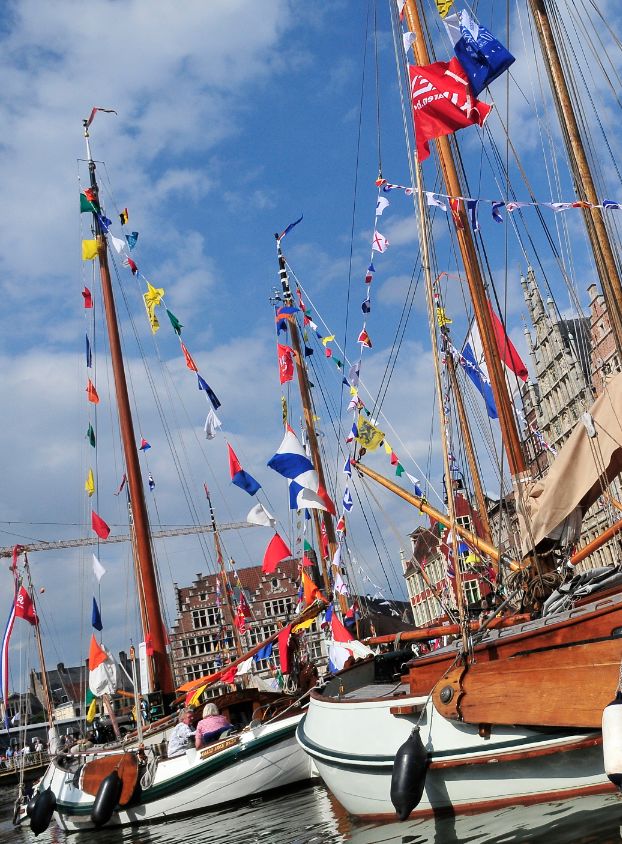
27th
World
Canals
Conference
7-‐10
September
2015
Ghent,
Belgium
Abstract
Book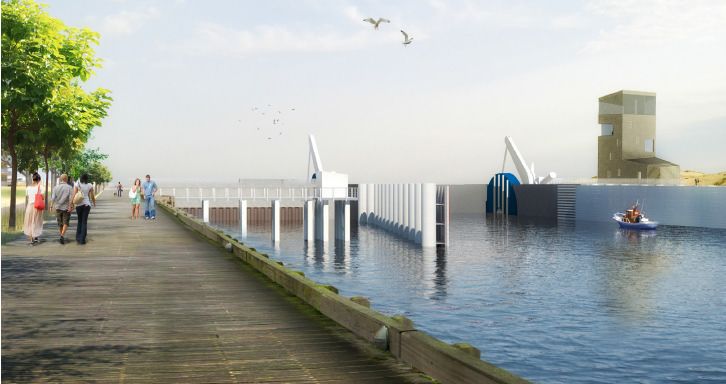
TABLE OF CONTENTS

Theme 1: Waterways in International Perspective

 The importance of the Ghent waterways in the past and in the future ……… 5

The Seine-Scheldt project …………..................................................................... 6

Unique location of port of Ghent does not only attract thousands
    of inland vessels but also hundreds of inland cruises ……..............….. 7

The river Lys, international cooperation …………............................................. 8

The Central Commission for Navigation on the Rhine (CCNR) …................... 11

Inland waterways development in Wallonia within a European
     perspective ..............................................................................................… 12

Why and how to keep small canal waters alive. For example in the
    Netherlands. And how to reuse them …................................................… 13

Globalising the Kelpies ………….................................................................…… 15

The port of Terneuzen in relation to the port of Ghent ……………..............… 17

Germany's new Inland Waterway network bridging East and West……......… 18

Theme 2: Waterways in economical perspective

 Innovation in the service of conservation : ensuring the sustainability
     of Parks Canada’s historic canals by revenue generation …….........… 20

 A Renewed Era in Development along the Erie Canal ……........................… 23

 Optimizing navigation areas to increasing ship dimensions …….............… 24

 The Shannon Blueway – bringing prosperity to Ireland’s Inland
    Waterways ……........................................................................................… 25

 A study of Revitalization of Coastal Shipping Using the Gyeong-in Ara
     Waterway ……..........................................................................................… 26

 The economic perspective of the waterways in Flanders ……..................… 27

 Urban waterways from an economic point of view …….............................… 29
Theme 3: Waterways in historical perspective

The Lieve, a 13th century canal from Ghent to the North Sea ……............… 32

 “IRON GATES“ – Đerdap / Danube through history ……...........................… 34

Discovering the identity of oriental cultural landscape – from ancient maps
     of Grand Canal …….................................................................................… 35

The inventory of the Flemish heritage fleet ..................................................... 38

Teaching Towpaths & Tugboats : Using New York’s canals to engage &
    inspire youth ……....................................................................................… 39

The inundation of the Yser ……......................................................................... 42

Theme 4: Waterways in ecological perspective

Reconciling ecology and economy: smart ecology restoration based on
    functional win-win situations ….................................................…........… 44

The impact of climate change on water management ……..........................… 45

Tourism and wildlife conservation - incompatible?……..............................… 47

Newpoort : Storm surge barrier ……..............................................................… 49

WSG technology in the service of waterways and hydrotechnical
   engineering .…….....................................................................................… 50

Towards an Improved Business Relationship – Waterpower on Parks
    Canada Canals ……................................................................................… 51

Theme 5: Waterways in touristic-cultural perspective

 Burgundy – France: an innovative governance to boost the touristic
    development of the waterways …….......................................................… 55

 London – a case study ……...........................................................................… 58

 Waterways and tourism in Flanders ……....................................................… 60
Newbuilding of the slope at the sluice complex Ganzepoot in
    Nieuwpoort ……......................................................................................… 62

Blue Hub Rupel: an innovative and sustainable tourism challenge …........… 63

Can the Lombard Inland Waterways attract tourism and economy? ……...... 66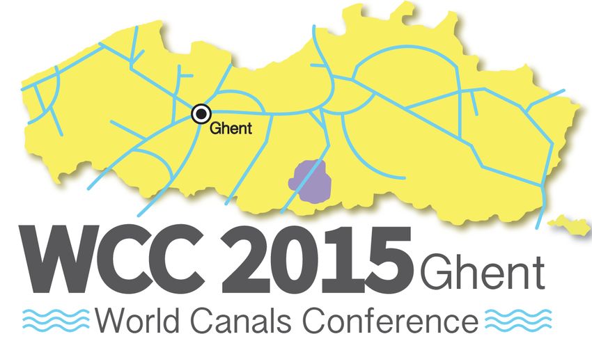
       27th
  World
  Canals
  Conference


                           Theme
  1:

       Waterways
  in
  International
  Perspective
Waterways in Ghent in historical perspective

Les cours d’eau de Gand à travers l’histoire

Geert Van Doorne

RÉSUMÉ
Je ne vous fatiguerai pas avec les innombrables tentatives des Gantois pour accéder à la mer
océane. Cela résulterait en une énumération d’avant-ports, de canaux maritimes et d’espaces
industrialisés somme toute assez banals. Je m’intéresserais plutôt à la question pourquoi et comment
la mer est venue à Gand. La réponse en est dans la cité même.
Toutefois, la première rencontre entre citoyens et marins fut loin d’être amicale. En 851, les Normands
ou Vikings remontaient l’Escaut et détruisaient la magnifique abbaye de Saint-Bavon à Gand. Les
ruines vénérables du monastère restent aujourd’hui l’un des endroits les plus romantiques de la ville,
tout près de son noyau primitif et du port de plaisance actuel nommé ‘portus Ganda’.
La fin des invasions et les succès des croisades amenèrent une véritable renaissance dans le nord-
ouest de l’Europe avec l’apparition des cathédrales gothiques et d’un réseau de villes commerçantes
où la nouvelle culture bourgeoise du libre échange se fit jour. C’est alors qu’on voyait les premières
galères méditerranéennes dépasser le Cap Finistère et s’engager dans la Manche. Alors aussi, Gand
et la Flandre deviennent le principal centre de production d’ étoffes laineuses. Située au confluent de
quatre rivières, l’Escaut, la Lys, la Liève et la Moere, la ville de Gand constituait le portail d’entrée
depuis la mer océane dans l’arrière-pays européen. L’opulence créée par le commerce actif et
l’industrie du textile nous a légué jusqu’à ce jour le vieux-port du Quai aux Herbes avec ses façades
prestigieuses, le Château des Comtes et l’Agneau Mystique, nombre d’églises et de cloîtres superbes
et plus de cent cryptes et caves, les entrepôts de jadis, dans les rues du centre-ville.
Après la découverte et la conquête du Mexique et des autres pays d’Amérique, plutôt des Indes
Occidentales, sous l’égide de l’empereur gantois Charles-Quint, notre ville a participé au trafic
transatlantique grâce au canal du Sas et au canal de Bruges et d’Ostende. Ce dernier est surtout
célèbre par ‘la barge’, coche d’eau au bord duquel le roi Louis XV a fait le voyage de Bruges à Gand
en 1745. Pendant la révolution industrielle, Gand est devenu le majeur port cotonnier du continent
européen. Les Vieux Bassins qui datent de cette époque fiévreuse sont maintenant en cours de
rénovation.

ABSTRACT
My starting point is not the classical question: why and how did Ghent strive after an issue to the sea?
I prefer the question inside out: why and how did the sea come towards Ghent? The answer to the first
question offers only images and stories about maritime canals and forward-ports on the coastline. The
second question finds its answer in the old city it selves.
However, the first contact between the citizens and the seamen was not a happy one. In 851 the
Normans or Vikings sailed upstream the river Scheldt and destroyed the magnificent cloister of St
Baaf at Ghent; nowadays the ruins of this abbey form still the most romantic site of the town, nearby
the place of its origin and the actual marina “portus Ganda”.
After the end of the invasions and the successes of the crusades, a real renaissance was going on in
the northwest of Europe with the birth of the gothic architecture and a network of cities whose middle
class elaborated a new kind of economy based on trade and industry. It was then that the first
Mediterranean galleys passed Cape Finistere and entered the British Channel. Then as well Ghent
and Flanders grew up as the greatest production centre of wool textiles. Situated on the confluent of
the Scheldt and the Lys, the Lieve and the Moere, Ghent was the ideal entrance to the continental
markets. The then prosperity is testified by the prestigious buildings on the old inner-city harbour of the
Graslei, by the impressive Castle of the Counts, the numerous and beautiful churches and
monasteries, and more than hundred crypts and cellars in the medieval city centre.
At the time of the great discoveries and the conquest of America, Ghent participated on the
transatlantic adventure by two newly dug sea canals: the so-called Sassevaart and the Brugse vaart.
The last is well-known by its daily public boat “de barge”, described by William Makepeace Tackeray
in his novel Vanity Fair. The industrial revolution gave Ghent the greatest cotton-port of the European
continent. The old docks which commemorate these activities are actually renovated.

                                                                                                         5
The Seine-Scheldt project

Le projet Seine-Escaut

ir. Frank Serpentier
Waterwegen en Zeekanaal NV, afdeling Bovenschelde, Guldensporenpark 105, 9820 Merelbeke
(frank.serpentier@wenz.be)

RÉSUMÉ
Waterwegen en Zeekanaal NV (W&Z) est l’autorité flamande responsable de la gestion des rivières et
canaux navigables dans la partie occidentale de la Flandre. Dans un effort continu d’améliorer et de
renforcer ce dense réseau fluvial et de promouvoir son utilisation par la navigation intérieure,
Waterwegen en Zeekanaal, ensemble avec ses partenaires français et wallons, s’est engagé ces
dernières années au développement et à la réalisation du projet Seine-Escaut. Ce projet européen
fluvial envisage de créer une liaison fluviale à grand gabarit entre les bassins de la Seine et de
l’Escaut, supprimant un important goulet d’étranglement pour la navigation intérieure sur le corridor
européen multimodal Mer du Nord – Méditerranée. En Flandre, le projet est déjà en pleine cours et se
concentre principalement sur l’axe dite de la Lys, formant la liaison directe entre la frontière française
et la ville de Gand. Cependant, une attention particulière sera aussi donnée à l’amélioration des voies
hydrauliques avoisinantes et aux connexions avec les ports maritimes flamandes. En outre, à part des
mesures infrastructurelles, un important programme de restauration rivière sera implémenté,
améliorant la qualité écologique, récréative et paysagère de la rivière de la Lys et de sa vallée. Avec
cette approche de projet intégrée, W&Z espère d’encourager et de souligner l’utilisation
multifonctionnelle et durable de ses voies navigables, les rendant une place centrale dans le
développement économique et sociale de la région.

ABSTRACT
Waterwegen en Zeekanaal NV (W&Z) is the Flemish waterway authority responsible for the
management of the navigable rivers and canals in the western part of Flanders. In a continuous effort
to further improve and strengthen this dense waterway network and to promote its use for inland
navigation, Waterwegen en Zeekanaal, together with its French and Walloon counterparts, has in
recent years been fully committed to the development and realization of the Seine-Scheldt project.
This European waterway project aims to create a large-gauge waterway link between the Seine and
Scheldt basins, removing an important bottleneck for inland navigation in the multimodal European
North Sea – Mediterranean corridor. In Flanders, the project is already well underway and focuses
mainly on the so-called Lys axis, forming the direct link between the French border and the city of
Ghent. However, due attention will also be paid to the upgrading of the surrounding waterways and
the connections with the other Flemish maritime ports. Also, besides the infrastructural upgrades, an
important river restoration program will be implemented, improving the ecological, recreational and
scenic quality of the river Lys and its valley. With this integral project approach, W&Z hopes to
encourage and emphasize the multifunctional and sustainable use of its waterways, giving them a
central place in the economic and societal development of the region.

KEYWORDS
Infrastructure, TEN-T corridors, Seine-Scheldt, inland navigation, cross-border projects

                                                                                                        6
Unique location of port of Ghent does not only attract thousands of
inland vessels but also hundreds of inland cruises

L’emplacement unique du port de Gand n’attire non seulement des
milliers de navires intérieurs mais aussi des centaines de navires de
croisière intérieurs

Daan Schalck
Ghent Port Company, John Kennedylaan 32, 9042 Ghent (D.Schalck@portofghent.be)

RÉSUMÉ
Gand est situé au carrefour européen d’importants canaux et rivières. Un vaste réseau de voies
navigables lie Gand par rivières et canaux aux Pays-Bas, à l’Allemagne et au nord de la France (Paris
via la liaison Seine-Nord). L’aménagement de la voie navigable entre la Seine et l’Escaut entraînera
que des navires intérieurs plus grands pourront naviguer par la liaison entre le port de Gand, les Pays-
Bas et la France (avec le grand marché de la conurbation de Paris et le nord industriel de la France).
En Flandre, le projet se déroulera principalement via la rivière de la Lys et le Canal périphérique
autour de Gand. De plus, Gand est également lié au réseau de canaux et rivières de l’Europe de l’est
du Rhin-Main-Danube. Grâce à son emplacement, le port de Gand a une position unique comme
centre de transbordement entre la navigation maritime et intérieure pour tout type de marchandises.
En 2014, le port de Gand a reçu quelque 15.000 navires intérieurs, représentant un trafic de
marchandises de 21,8 millions de tonnes (sur un total de 47,7). Non seulement les cargos intérieurs
trouvent leur route vers Gand. Pendant les dernières années, le port gantois a créé la tradition que
beaucoup de navires de croisière intérieurs y font escale. En une période de dix ans, ce nombre a
plus que triplé. La plus grande partie vient de l’Allemagne et de la Suisse. Le nombre d’arrivées le
plus élevé de tous les temps a précisément été noté pendant la saison passée de 2014. Alors un total
de 266 navires de croisière a fait escale à Gand emmenant presque 29.000 passagers à Gand.

ABSTRACT
Ghent is located at the European crossroads of important inland waters. An extensive network of
inland waterways connects Ghent via rivers and canals with the Netherlands, Germany and the North
of France (Paris via Seine-Nord connection). Improving the waterway between the Seine and the
Scheldt means that bigger inland navigation vessels will be able to make the connection between port
of Ghent, the Netherlands and France (with a large market in the Paris conurbation and the industrial
north of France). In Flanders the project will run mainly via the river Lys and the Ring Canal around
Ghent. Moreover, Ghent is also connected to the East European inland navigation network of the
Rhine-Main-Danube. Due to this location, port of Ghent takes up a unique position as a transhipment
centre between seagoing and inland navigation for any type of goods. In 2014, port of Ghent received
some 15,000 inland vessels, good for a cargo traffic of 21.8 million tonnes (of a total of 47.7). Not only
inland cargo vessels find their way to Ghent. In the past few years, Ghent port has been building up
the tradition that quite a lot of inland cruise vessels call there. In ten years’ time, this number more
than tripled. The larger part comes from Germany and Switzerland. The highest number of arrivals
ever was precisely registered in the past season of 2014. Then, a total of 266 cruise ships arrived in
Ghent bringing almost 29,000 passengers to Ghent.

KEYWORDS
Crossroads of inland waters, inland cruises, Seine-Nord connection, transhipment centre

                                                                                                        7
Waterways in a cultural-touristic perspective: water recreation and
tourism

Katrien Six
District manager Tourism Leiestreek

ABSTRACT
‘Toerisme Leiestreek’ npo was created in 2000 and reunites 28 cities and towns in the Lys area
around a series of communal objectives such as determining touristic-recreational policy planning,
enhance the promotion of the Lys area as touristic-recreational region. ‘Toerisme Leiestreek’ is
financed by the provinces of Western and Eastern Flanders and the 28 towns and cities.
Most towns and cities in the Lys area are situated along a waterway. These rivers and canals are a
significant binding element for the Lys area. Experience on and along the waterfront is therefore one
of the central themes highlighted for the promotion of the region. The cooperation around the boat
trips are the basis for creating npo ‘Toerisme Leiestreek’.
In order to improve the facilities and to strengthen the promotion of the region, ‘Toerisme Leiestreek’ is
already cooperating for a decade with the French sister organization, Lys sans Frontières, in various
European projects. The Lys, also called the Golden River, is namely the ‘blue guideline’ in the region
and connects inhabitants, tourists and holiday-makers in the French and Flemish Lys area.
The presence of water in the Lys area distinguishes our region from other tourist regions in Flanders.
The rivers Lys and Scheldt constitute the 2 major recreational axes.
Although sailing tourism is rather a niche [market] within the tourist and recreational offer in the Lys
area, it still remains a significant element to the organization ‘Toerisme Leiestreek’ (Tourism Lys
Area). Both passenger navigation as well as individual pleasure cruising are included in the promotion
of the region.

Introduction
‘Toerisme Leiestreek’ npo was created in 2000 and reunites 28 cities and towns in the Lys area
around a series of communal objectives such as determining touristic-recreational policy planning,
enhance the promotion of the Lys area as touristic-recreational region. ‘Toerisme Leiestreek’ is
financed by the provinces of Western and Eastern Flanders and the 28 towns and cities.
The Lys region is an extensive area with a considerable diversity. It is also a region that crosses the
borders of our province. Yet, there is one common denominator, i.e. the water, an element that is
highlighted during every action or initiative undertaken by ‘Toerisme Leiestreek’.

Water recreation and boat trips
Since the end of the nineties, the provinces of West Flanders and East Flanders have played an active
role in enhancing the facilities for individual pleasure cruising and its promotion.
Next to the efforts with respect to individual pleasure cruising, the tourism offices in the Lys area have
also initiated since the end of the nineties a detailed programme for passenger navigation, provided in
the form of organized boat trips during the summer months. These boat trips allowed a large audience
to discover the region from a different perspective, namely from the waterways. Owing to the
organization of these boat voyages, the links between the towns and the cities in this region was
strengthened.
This cooperation as regards boat trips in the Lys region entailed in the creation of the ‘vzw Toerisme
Leiestreek’ (npo Tourism Lys Area) in 2000. Without these boat trips, Tourism Lys Area would
probably not even exist. Owing to this product, we have come to grips with the tourist regional
cooperation in the Lys area. Intermunicipal cooperation about a concrete product such as the boat
trips reinforces the mutual cohesion and clearly demonstrates the surplus value of a regional
approach.
The boat trips in the summer season attract a loyal audience, but it can be extended by contacting
smaller shipping companies with a varied offer for couples, a small circle of friends or families. Such
private-public cooperation can entail in a surplus value for both parties and help us to upgrade the
significance of the Lys Area as a sailing region.
As a first step, we have published the brochure ‘Pleziervaart en waterpret in de Leiestreek’ (Pleasure
cruising and water fun in the Lys Area) that we presented this spring. In recent years, there was a
need for a comprehensive offer with respect to recreation in, on and along the water. This new
brochure is an answer to this necessity. Owing to this publication, visitors possess a detailed offer of

                                                                                                        8
readily available water recreation. Beside a survey of the various shipping companies, it also includes
a wide range of watersports opportunities and open air swimming pools. Evidently, the organized
summer boat trips are also mentioned in this brochure.
However, tourism along the water cannot be forgotten In the first instance, we are thinking about
cycling on the towing paths along our rivers and canals. The ‘Fietsnetwerk Leiestreek West’ is a
bicycle network boasting the largest percentage of carless cycling paths in West Flanders, of which
the towing paths constitute a significant part. Flemish people are Burgundians, wishing to interrupt
their bicycle tour for a beverage and a snack. In this respect, the wide array of ‘terraces at the
waterside’ in our region are a major asset. Some of them are also renting boats and are equipped with
a proper jetty.
European projects
In the past, we participated as a partner or as a project leader in some European projects in view of
highlighting the assets of water recreation.
Largely owing to European subventions for tourist projects, we were able to put the Lys Area on the
map as a tourist region. ‘Toerisme Leiestreek’ on the one hand acting as a Flemish partner, and ‘Lys
sans Frontières’ as its French counterpart on the other hand, have cooperated for over a decade to
the valorization of this region.
It started with an INTERREG III project, that took place between 2000 and 2007 and was followed by
an INTERREG IV project, from 2008 up to and including 2014.
Between 2008 – 2011, during the first phase of the INTERREG IV project ‘Leiestreek, van bron tot
monding’ (The Lys Area, from source to estuary), a total sum of € 10,5 million was invested in the
tourist and recreational offer in the Lys area and the promotion of the region. € 3,9 million of this
budget was provided by the European Union via the INTERREG programme for the region France -
Wallonia – Flanders.
In concert with the partners in the French Lys Area, ‘Toerisme Leiestreek’ and individual towns and
cities in the region, projects were being set up as regards patrimony, gastronomy, cycling and walking
and river tourism. Westtoer was the project leader of this venture.
During the 2nd phase of the project ‘Leiestreek, van bron tot monding’ (The Lys Area, from source to
estuary), ‘Toerisme Leiestreek’ intended to make a continuation of this cross-border initiative. This
was achieved with a project budget of nearly € 2,4 million, including € 1,15 million European
subventions during the period 2012 - 2014.
The deployed means comprehended both promotional campaigns as well as infrastructure operations.
The first aspect cannot be achieved without the second aspect.
Some examples of various concrete European projects were:
1. De Vlaamse Leiestreek (The Flemish Lys Area)
• The construction of a main jetty, access walkaway and access tread in the Kloron marina at
Avelgem.
• The construction of a jetty in the centre of Harelbeke.
• The construction of a jetty in Zwevegem.
• An extension of the number of mooring places at the marina in Waregem and some
improvements concerning the infrastructure.
• The construction of a floating pontoon for small and middle-sized vessels near the Tobacco
Museum in Wervik.
• The construction of a new jetty for the former Pumping building in Bossuit.
• The reconstruction of the Leiedam in Deinze was a sizeable project in the theme of water
recreation. In the scope of an urban renovation project, a mooring and a promenade were
erected near the Sint-Poppoplein.
• Amelioration works were achieved at the transient port in Kortrijk, including information panels
in four languages.
• The town of Sint-Martens-Latem has initiated preliminaries in view of amelioration works at the
banks of the Lys.
• Toerisme Leiestreek organized boat trips during the summer on rivers and canals in the
region. The comprehensive programme included trips which brought the participants to
France. There were also voyages combining sailing and bicycle tours.
• So as to mutually enhance the cooperation with the private sector and between various tourist
actors, ‘Toerisme Leiestreek’ initiated the new concept of ‘speed dates’. In 2013 and 2014,
various speeds dates were held, having as main objective to allow actors from the public and
private tourist sector to gain improved acquaintance and promote closer cooperation.
9The participants originated both from the Flemish as well as the French Lys area, and the
programme boasted both thematic as well as geographic speed dates. Some of the meetings
were attended by over 40 persons, including boat and bicycle lessors, restaurants, hotels,
B&B’s, npo’s, recreational domains, guide associations,… The speed dates entailed in
concrete results, such as the Ghent-based boat rental company MINEVA which provided a
selection of regional specialties to boat renters, in cooperation with Brewery Gruut, also
located in Ghent.
• In order to highlight the new offer, special attention was paid to promotional activities. Thus,
‘Toerisme Leiestreek’ participated in some specific fairs, both at home and abroad: the
Belgian Boat Show in Ghent, the International Boat Show in Nieuwpoort and Boot in
Düsseldorf.
The boat itinerary ‘Leie en Schelde’ (Lys and Scheldt), comprising a survey of the waterways,
marinas and jetties in the area was designed in a joint cooperation with ‘Toerisme Oost-
Vlaanderen’ and ‘Toerisme Gent’.
Furthermore, various press conferences and trans-border press trips were being held, paying
particular attention on water recreation. These voyages sailed on the Oude Leie between Sint-
Martens-Latem and Deinze.
2. De Franse Leiestreek (The French Lys Area)
• The Haverskerque marina was entirely renovated, including new pontoons and a pedagogic
pool. The recent extension allows ships from over 16 meter length to enter the marina.
• Also in Haverskerque, the ‘Communauté de Communes Flandre-Lys’ has created a Port
Master’s Office, equipped with state-of-the-art technologies. The service for yachtsmen of
pleasure crafts was improved, providing installations for water, electricity, sanitary facilities,
small repair sets and tourist information.
• In 2003, ‘Lys sans Frontières’ has made new signposts for yachtsmen of pleasure crafts. Over
80 signposts were set up between Aire sur la Lys and Halluin.
• The annual Lys festivities have repeatedly put ‘The Golden River’ in the spotlights in the
various towns and cities of the French Lys area.
In brief, water tourism has been a constant source of attention in the activities deployed by ‘Toerisme
Leiestreek’, since its creation in 2000 until now, and as much as possible in cooperation with our
French partners to keep track with the international context.
10The Central Commission for navigation on the Rhine (CCNR) at 200
- Towards a pan-European waterway-system for the 21st century
Yvo J.D. Peeters, MA, Med, MSc, LLED.
Former Head of Foreign Policy Unit of the Waterways Administration of Flanders
ABSTRACT
The CCNR was created by the Treaty of Vienna which ended the Napoleonic Wars in 1815. It is as
such the oldest international Institution of the World.
It has contributed tremendously in the past two centuries towards regulations, especially for traffic and
safety on Europe’s main waterway.
th
In the second half of the 20 Century of the main natural waterways of continental Europe were linked
by Canals, partiarlarly so the Rhine and Donau, which could prefigurate a larger system.
After 1991, the collapse of the socialist dictatorships opened new perspectives for a Pan-European
system. In 2001 and 2005 two major conferences initiated by the Netherlands were held to that aim.
Since then the process has lost some of its momentium.
The soon to be realised Seine-Schelde link may well be the opportunity to give it a boost.
The most realistic option is to extend the “Rhine-System”, adapted where necessary, to the whole
European Waterwaynetwork.
11Inland Waterways development in Wallonia within a European
perspective
Le développement des voies d’eau intérieures en Wallonie dans une
perspective européenne
Yvon Loyaerts
Service public de Wallonie
RÉSUMÉ
La Wallonie occupe la moitié sud de la Belgique. Son réseau fluvial, long de 451 km de voies
navigables, est constitué de voies d’eaux naturelles canalisées (la Meuse et l’Escaut principalement)
mais aussi d’importantes voies artificielles (Canal Albert, Canal du Centre, Canal Bruxelles-Charleroi,
…). Modernisé progressivement au fil des siècles et tout particulièrement lors du 20° siècle, il intègre
la Wallonie dans le réseau européen en connexion avec les régions et pays limitrophes (Pays-Bas,
France, Allemagne).
Au sortir de la seconde guerre mondiale, un ambitieux plan de modernisation a permis de porter le
réseau wallon aux standards européens de l’époque (Classe IV – Bateaux de 1350 t). Le programme
a nécessité la rectification ou l’élargissement de plusieurs canaux et rivières et la construction de
nombreuses nouvelles écluses. Il s’est achevé en 2002 par l’ouverture des ascenseurs à bateaux de
Strépy-Thieu, dans le Hainaut.
Actuellement, l’ambition nouvelle est de porter l’ensemble de la dorsale wallonne au gabarit Va (2000
t), afin de relier entre eux les bassins de l’Escaut et la Meuse, eux-mêmes voyant leurs capacités
augmentées respectivement jusqu’à 4500 et 9000 t.
Par cette politique volontariste, la Wallonie entend s’inscrire dans la stratégie européenne des
corridors multi-modaux, en particulier le corridor Mer du Nord – Méditerranée au sein duquel est repris
l’ensemble du réseau wallon à grand gabarit. La programmation, définie e.a. en relation avec le projet
Seine-Escaut, est prévue jusqu’en 2025-30.
ABSTRACT
Wallonia is the southern half of Belgium. Its 451 km long inland waterways network is made up of
canalised rivers (mainly the rivers Scheldt and Meuse) but also of important man-made canals (Albert
Canal, Canal du Centre, Canal Brussels – Charleroi,…). Modernised step by step all along the
centuries, and mainly during the previous one, it puts Wallonia within the European network,
connected with the neighbouring regions and countries (Flanders, France, the Netherlands, Germany).
After WWII, an ambitious upgrading programme brought the Walloon network to the European
standards at the time (Class IV – 1350 t). The programme needed the rectification or the enlargement
of several rivers and canals and the building of some new locks. It was achieved in 2002 when the
boat lifts of Strepy-Thieu, close to city Mons, were brought into service.
Nowadays a new programme has been defined : to bring the whole Walloon waterways backbone till
class Va in order to better link both Scheldt and Meuse basins where the capacity will simultaneously
be raised till 4500 and 9000 t respectively.
Thanks to this voluntary policy Wallonia plans to be fully integrated within the European multi-modal
corridors strategy, more specially the North Sea – Mediterranean corridor wherin the whole Walloon
network is included. The time schedule has been defined till 2025-2030, in relation with the Seine –
Scheldt project.
12Why and How to keep small canals alive. For example in The
Netherlands. How to re-use them.
Nederland Kanalenland? Land van kanalen: Waterways-Ways of
Value.(c).
JanPieter Janse
GolfslagAdvies& Projecten Historisch Water Groningen/The Netherlands
www.watererfgoed.nl, www.oudewinschoterdaipopen.nl, 0031502806018
ABSTRACT
Duizenden kilometers kanalen kent Nederland. In 2014 komt de grootscheepse omlegging van de
Zuid Willemsvaart in Brabant(Zo-NL) tot stand. Het Canal du Nord, begonnen onder Napoleon tijdens
de bezetting van de Zuidelijke Nederlanden werd nooit voltooid. Een kanaal op het eiland Marken
werd wel ontworpen maar niet gegraven. Van de rivier de Rijn werd een kanaal gegraven om een
directe verbinding tussen de Rijn en de Zuiderzee te maken. Slechts sporen in het landschap en
vergraven sloten bleven over. In Nederland bestaat geen overzicht van door eeuwen heen, verlaten
kanalen. Geldgebrek, oorlogen, geschillen tussen koningen en graven en bisschoppen, kortom de
eigenaren van gronden lagen meestal ten grondslag aan het verlaten van noodzaken om het””
voorgenomen “’kanaal”” af te kunnen maken en haar functies voor waterhuishouding, transport van
personen en goederen te kunnen vervullen. Lost Canals in Landscape. Hardly to find,hardly to Re-
Use. In 2014 verschijnt een belangrijk artikel van Arjan Heijdra e.a , Rijkswaterstaat. Met als titel”’
Resilience of Waterways systems-an explorative study of the American, Dutch and German waterway
systems. Opnieuw worden vanwege kosten, veroudering van voorzieningen, sluizen en kaden, kanaal
profielen,ontwikkelingen in beroepsvaart, kanalen tegen het licht gehouden.
Nieuwe Lost Canals komen er weer aan.
Functie verlies vanwege economische ontwikkelingen of oorlog, wijzigingen van regiem zijn van alle
tijden. Een kanaal zonder functie is een bak met water in het landschap.
Rond 1800 moest Het Canal du Nord Brussel met de Rijn verbinden.156 km lang. Financering zou
plaats moeten vinden via overheidsmiddelen. In 1810 werden de werkzaamheden gestaakt. Later
onder bewind van Koning Willem 1, de Kanalen koning werden de werkzaamheden hervat, maar dat
kanaal zou nu de Zuid-Willemsvaart worden.Nu weer onderdeel van een belangrijke route voor de
beroepsvaart en de recreatievaart voorzeningen”’ontwikkeld als “”Willemsroute””. Vanuit marketing en
economische, meer recreatieve belangen voor de Provincies Limburg(Belgie en Nederland).
Nederland kent 3 Willemsvaarten.Waarvan 2 in gebruik, waarvan 1 in Zuid Nederland en Belgie en
een het Noord Wilemskanaal in Drenthe,De vaarverbinding Hoofdstad Assen met hoofdstad
Groningen. En een…. Lost Canal in Overijssel- Stad Hoofstad Zwolle. Het kanaal is afgesloten en
deels gedempt vanwege aanleg van een verkeersweg en verworden tot een smalle sloot en aan het
einde , bij de toegang tot de rivier de Gelderse Ijssel een prachtig authentiek vol gerestaureerd
sluizencomplex. Innovatief met in een sluis een gemaal en de andere sluis voor recreatievaart. Echter
doorvaart verboden. Een voortreffelijk voorbeeld van bevoordeling van autoverkeer en ontsluiting van
een stad dmv het dempen van een vaarweg van formaat met een hoge cultuurhistorische en
potentieel recreatieve en economische waarde.
Nederland kent talloze Lost canals, vanwege functie verlies, veranderd landgebruik,wijzigingen in de
landbouw toename landverkeer, groei van transport over water en groei van schepen en
aanpassingen aan kanaalprofielen. Evenzo Lost Canals vanwege bestuurlijke aanpassingen vanuit de
Rijksoverheid, Provincies en Waterschappen/Gemeenten. Feitelijk een voortdurend proces,
waarbinnen de toe te kennen waarden aan kanalen, grote en kleine kanalen, vaar-en
waterverbindingen afwezig zijn in vastgelegd beleid en wetgeving op landelijk en lagere niveaus.
Kanalen, samenhangende voorzieningen van bruggen, sluizen, kaden, loswallen en jaagpaden,
bebouwing en fabrieken en landschap zijn onbeschermd als cultuurhistorisch goed. Er is geen
landelijke organisatie die dergelijke kanalen in hun “”afstotings”’proces”’ nog over nemen kan.
Voorbeeld 1: Her-benutting Apeldoornskanaal van Koning Willem 1.
Voorbeeld 2: Her-aanleg van kanalen tussen Groningen en Duitsland met de in 2013 geopende
prachtige en unieke nieuwe vaarverbinding: Het Koning Willem Alexander kanaal, ook wel KWAK-
kanaal in de volksmond zo genoemd.
Keert het TIJ: Wordt het Eb of vloed?
13In 1976 lijkt het tij te keren, Eb was het al: ANWB, Bond Heemschut en het Koninklijk Nederlands
Watersportverbond publiceerden een eerste overzicht van de waarden van kanalen en in het bijzonder
oude kanalen in steden en landschap. De brochure 1976 daaraan ten grondslag, was baanbrekend.
Samengesteld op basis van uniek onderzoek van Ing. E.J.W Gratama van Andel en heeft uiteindelijk
mede geleid tot het medio 1995 oprichten van de Landelijke Organisatie Stichting Recreatie Toervaart
Nederland(SRN), nu in 2014 omgevormd tot Waterrecreatie Nederland. De brochure was
baanbrekend: Ook voor mijzelf, eigenaar van een oud te restaureren 24,50 lang, bijna 5 meter breed
meter voormalig Noord Gronings gemotoriseerd zeil- vrachtschip. Oude kanalen bevaren leek de
grote vakantie wens. De eerste ontwikkelde Turfroute van Nederland werd bevaren evenals andere te
ontdekken kanalen, die veel vaker gesloten waren dan op de waterkaart stond aangegeven. Frankrijk
lokte. Canal du Nivernais werd het doel. Alleen huishouden, studie, een oud huis en werk bleken in de
(vaar)weg te liggen
Recreatie vaart komt in grote ontwikkeling vanaf de 30er jaren(1)(1930) kon met de lobby en
economische maar vooral de vrije tijdsbelangen grote druk uit oefenen op overheden. Gelden werden
dan ook in ruime mate besteed aan het oplossen en verminderen van knelpunten in vooral oude maar
ook nieuwe vaarwegen. Geld kwam aanvankelijk van Ministerie van Landbouw en provincies. SRN,
het samenwerkingsverband van overheden en belangenorganisaties heeft voortreffelijk werk gedaan.
Routes werden hersteld, sluizen nieuw gebouwd, bruggen aangelegd, pleidooien en realisaties van
Aquaducten mn in Friesland en recent in de Steenbergsevliet(2013).Vaarwegnormering, normering
van recreatieschepen voor recreatieve vaart werd ontwikkeld. Routenetwerken werden hersteld.
Vaarwegnormering werd ge -exporteert naar andere landen in telkens nieuwe Internationale
Samenwerkingsverbanden. SRN was een stevige supporter van IWI. Het Friese Merenproject en haar
economische en recreatieve effecten kent geen concurrentie.
Wat bleef: Gebrek aan landelijk beleid(NL) en (EU) , wetgeving en regelgeving op lager niveau voor
alle overgebleven Lost Canals en nieuwe Lost Canals vanwege het doorgaande proces van functie
verlies of juister, herwaardering van functies en herbestemming van oude en verouderde kanalen(dwz
gegraven of vergraven kleinere waterwegen).Ook ontbrak een in IWI verband ontwikkelde algemene
verklaring over de toe te kennen waarden aan waterwegen in landschap, waterkanten, steden,
voorzieningen en beleving. Eerst vanuit initiatief tot het komen van de eerste Internationale Kanalen
Conferentie in Nederland in 2011, kon samen met partners en deelnemers de Verklaring van
Groningen WCC2011 worden voorbereidt, opgesteld en op het 24e congres aanvaard worden.
Evaluatie van landelijke en internationale ontwikkelingen, die telkens tot “”Lost Canals”” leiden
ontbreekt in IWI en Eu verband.
In 1984 werd de aanzet voor een dergelijk waarderingssysteem opgezet doch landelijk afgeblazen
vanwege gebrek aan politieke interesse, daardoor geldgebrek voor vervolgonderzoek en
implementatie van een te ontwikkelen systematiek voor het op-dan wel afwaarderen van oude kanalen
en hun voorzieningen in het landschap.
Ik zal trachten aan te tonen dat een dergelijke wettelijke systeem onontbeerlijk was, is en wordt
teneinde doorontwikkeling van oude kanalen en doorgaande, aansluitende vaarwegen ook met
Duitsland en Belgie voor recreatie (vaart) en kleine beroepsvaart(w. o motorcharter).
-Met enkele praktijk voorbeelden. W. o Oude Winschoterdiep te Groningen en Apeldoorns kanaal in
Gelderland.
-Pleiten voor daadwerkelijke implementatie Nationaal en Internationaal van de Verklaring van
Groningen(WCC2011)in beleid en regelgeving /wettelijke maatregelen.
-Een eerste concept van een dergelijk systeem opnieuw introduceren.
-Pleiten voor opname van cultuurhistorie in beleid van Waterrecreatie(NL) en IWI als
waarderingsfactor voor vaarwegen en het beleven ervan voor toerisme, waaronder vaartoerisme.
-Waarderen van het belang van geregelde evaluatie van ontwikkelde vaarroutes op hun
daadwerkelijke economische (beloofde)impact. TW: Een(1) brug dicht(gelast) op een route, slecht
gastheerschap, gebrekkig onderhoud, niet op tijd baggeren, geen op elkaar ook internationaal
afgestemde bedieningstijden bij grensoverschrijdend vaarverkeer, onderwaardering van belangen van
lokale economie en bewoners langs een kanaal hebben grote invloed op draagvlak, nut en noodzaak
van politiek en beheerder/eigenaren van kanalen om deze verbinden ook voor langere tijd in stand te
houden. Om te voorkomen dat Nieuwe Lost Canals in een permanent proces van verloedering te recht
blijven komen. Of is dat onontkoombaar?
14Globalising the Kelpies
Richard Millar
Scottish Canals
ABSTRACT
Scotland’s canals were once the thoroughfares that stoked the fires of the industrial revolution –
transport arteries that carried coal, goods and life through the communities of the nation – and their
rich, 250-year-long history is tied intrinsically to that of the country itself.
The birth of the railway effectively sounded the death knell of the waterways as trade routes. Following
WWI, dwindling use and the march of rail and road freight meant that the canals became more and
more disused and derelict until, in the 1960s, many of Scotland’s canals – particularly in the Lowlands
- were filled in and replaced by motorways.
Stagnant and woefully undervalued, the canals became places of decay and danger – dark and dingy
backwaters which mothers warned their children to stay away from. It would take almost 40 years and
the biggest canal restoration project ever attempted in Britain to bring Scotland’s canals back to life.
The £83.5 million Millennium Link project saw British Waterways – Scottish Canals’ predecessor –
work with canalside communities, local authorities and a committed group of volunteers and societies
to restore Scotland’s waterways to a navigable state for the first time in a generation. A monumental
undertaking, the project saw the creation of more than 30 new bridges; the refurbishment of 32 historic
locks and 38 masonry spans; the construction of nine new locks; and the creation of five kilometres of
new canal. The 300,000 tonnes of silt removed during the project served as a stark reminder of the
scale of undertaking and the decay that had befallen Scotland’s canal network.
The centerpiece of the project, the iconic Falkirk Wheel, was – and remains – the world’s only fully-
rotating boat lift. A marvel of modern engineering, when the Wheel opened in 2002 it reconnected the
Forth & Clyde and Union Canals for the first time in over 70 years and quickly became a major tourism
destination. Today, the Wheel attracts 500,000 visitors a year and its design, named alongside the
likes of the Hoover Dam as one of the most iconic of the last century by the International Federation of
Consulting Engineers, is known the world over.
The worldwide success of the Wheel, which served as a platform to raise awareness of Scotland’s
inland waterways and a revolutionary symbol of their renaissance, whetted the nation’s appetite for
visionary, large-scale projects with international appeal. As a result, the next stage in the story of
Scotland’s canals was to be one of big ambitions – and bigger horses.
Originally conceived following the completion of the Wheel in 2002, the £43m Helix project aimed to
transform 350 hectares of disused land between Falkirk and Grangemouth into a vibrant new
parkland, marine hub and visitor attraction with the Forth & Clyde Canal at its heart. The centerpiece
of the project would be The Kelpies – the world’s largest equine sculptures. The colossal, 30-metre-tall
stainless steel structures would serve as an iconic monument to the horses that pulled the canal
barges of industrial age Scotland and a breathtaking gateway to the nation’s canal network.
But, long before the first piece of the sculptures’ steel skeleton arrived in Falkirk, plans were in place
to ensure The Kelpies were well-known on the world stage. One-tenth scale models of the colossal
works of art, known as maquettes, were created by sculptor Andy Scott as part of the funding bid for
the project and subsequently travelled all over the UK before memorably stabling in New York’s Bryant
Park as part of the city’s Scotland Week celebrations. Generating widespread coverage both at home
and abroad, the mini-Kelpies whetted the appetite of the public for the creation of their full-scale
siblings and played a key role in securing funding for the project.
From the moment the first piece of steel was placed alongside the Forth & Clyde Canal, The Kelpies
were an ever-present feature in national and international media. Augmented by a coordinated PR and
marketing strategy that positioned the sculptures as a world-class visitor attraction and supported by
an array of partners, from the Scottish Government to Visit Scotland, the three-month build saw The
Kelpies featured in more than 350 individual items of coverage, from The Times and BBC to New
15Zealand’s 3 News and The Baltimore Sun. The PR campaign also utlised various aspects of the
project, from the scultpures’ equine design to their complex engineering, to engage a huge variety of
specialised media worldwide.
A dedicated social media identity, distinct from the wider Helix project, was also created for The
Kelpies with the explicit aim of engaging an international audience. The page quickly gathered tens of
thousands of followers from all over the world keen to keep up-to-date with the project as it developed.
The Kelpies were officially unveiled to the world in April 2014 amidst a spectacular light, flame and
sound display by Groupe F – the pyrotechnic maestros behind iconic celebrations such as the
Millennium illumination of the Eiffel Tower and the opening of the world’s tallest hotel in Dubai.
Attracting more than 12,000 visitors and featured in news around the globe, the event signaled The
Kelpies’ arrival on the world stage and placed the sculptures, and the canal over which they stand
guard, firmly in the public eye.
Featuring a new one-kilometre canal extension and sea lock linking the Forth Estuary and River
Carron into the Forth & Clyde Canal, the project drastically improves access to the waterway and
removes the heavy reliance on tides that previously affected the lock. The new facilities also allow
boaters to enter the canal network before having to de-mast. The new lock also bypasses major
navigational restrictions in the form of the Kerse Road Bridge and the M9 Road Bridge, which cross
the River Carron.
The new sea lock will also widen the window of access to the canal, increasing the hours of transit
threefold for yachts and by almost 12 times for motor boats. One of the most complex sections of
waterway ever built in Scotland, the new canal passes under two major trunk roads – as well as
between The Kelpies – and dramatically improves access to the waterway. The one-kilometre
extension returns the Forth & Clyde back to its birthplace in Grangemouth some 250 years after it was
built, and is the final piece in the Millennium Link project. To date, the new section has increased boat
traffic in the area by around 30%.
In the 12 months following their unveiling, The Kelpies attracted more than 1 million visitors – far
outstripping the 350,000 estimated at the start of the project – and generating an additional £1.5m per
year for the local economy. Almost 20,000 people have also enjoyed a boat trip to The Kelpies and
more than 65,000 have stepped inside their steel frames and learned of their development as part of
formal tours. The popularity of The Helix has also driven the nearby Falkirk Wheel to its busiest year
since its opening, with the world’s only rotating boat lift attracting more than 500,000 visitors in 2014
as tourists combine a visit to The Kelpies with a turn on the Wheel.
The Kelpies were given their crowning glory in July 2015, when Her Royal Highness Princess Anne
performed the Royal Opening of the sculptures, travelling on the new canal section they reign over at
the head of a flotilla. A coordinated social media and marketing push, with support from local and
national partners, as well as the British Monarchy itself, resulted in a crowd of thousands attending the
visit, more than a quarter of a million people viewing content related to it and widespread media
coverage in a variety of outlets. From the date work began on the sculptures to the days following the
Royal Opening, the public had almost 1.5 billion opportunities to see print or online coverage of The
Kelpies and the canal they stand over.
The maquettes also continue to promote their towering siblings, with a carefully-coordinated touring
schedule seeing them stabled everywhere from the Royal Highland Show and Edinburgh Airport to the
Ryder Cup. Always popular sights at these high-profile events, the maquettes visits continue to
generate substantial traditional and social media coverage and prove an effective method of enticing
the international audience to find out more about The Kelpies.
The success of The Kelpies and the international appeal of the sculptures was only made possible
thanks to the ambition, drive and coordinated approach of the project partners. A strict set of
standards and guidelines, targeted marketing, PR and social media strategies, and partnerships with
key national and international agencies and organisations have combined to turn The Kelpies into
soaring, steel-clad icons that are recognised the world over and serve as a breathtaking symbol of the
bright future of Scotland’s canals.
16The Port of Terneuzen in relation to the Port of Ghent
Jan Lonink
Mayor of Terneuzen (Netherlands)
ABSTRACT
History
The Ghent – Terneuzen Canal is a special one. After the definitive divorce of Belgium and the
Netherlands in 1839, suddenly the canal was positioned in two countries. In 1827 the canal had been
opened to give the seaport of Ghent a gateway to the river Westerschelde, an estuary of the North
sea. This gateway knows a number of specific characteristics. The canal is about halfway divided in
two parts by the Belgian – Dutch border. In the past, Belgium and the Netherlands knew very different
strategic priorities: both banks of the Westerschelde are Dutch but the Westerschelde is the only
waterway to reach the Belgian ports of Ghent and Antwerp. In the past this was a very interesting spot
for tolls.
Present situation
All the while we are living apart together for almost two centuries. Ghent needs Terneuzen and
Terneuzen may pretty well use the Ghent dynamics to profit from the economic growth that is
generated by the Port of Ghent.
There are many reasons why the Belgian part of the canal is economically stronger. The growth of
Ghent is partly dependant on the infrastructural situation in the Netherlands. The present situation is
sufficient for the Netherlands but not for Ghent. In relation to the building of a new giant sea lock and
the choices about the depth of the canal are Ghent’s wishes leading the way. That’s why Flanders is
paying more than 80% of the costs of the new sea lock in the Netherlands. Flanders also paid the
additional costs for more deepening a traffictunnel on the Dutch part of the canal, only to avoid future
problems for the shipping to Ghent.
Future
At the moment on several occasions the past is still alive and still influences different bilateral
dossiers. However, European integration is in progress and to achieve a strong economic
development Europe will – in worldwide perspective – have to join forces and find a way to break
down the negative consequences of borders. This is the intention of both the cities of Ghent and
Terneuzen and of both port authorities. There is no other option than crossborder cooperation to
develop the Ghent – Terneuzen area into a strong economic centre.
17Germany's new Inland Waterway network bridging East and West
La mise en réseau des voies navigables secondaires d'Allemagne,
itinéraires touristiques entre Est et Ouest.
Hartmut Ginnow-Merkert1, Helmut Berends2
1Unser Finowkanal e.V., Melchower Ring 43, 16244 Schorfheide, Germany; unser-finowkanal@t-
online.de. 2Netzwerk Deutsche Wasserwege, c/o Helmut Berends, Wachtstraße 17-24, 28195
Bremen, Germany; info@netzwerk-deutsche-wasserwege.de.
RÉSUMÉ
Les plaisanciers souhaitant parcourir la voie navigable internationale E70 qui traverse l'Europe
d'Ouest en Est rencontrent une difficulté: sur leur parcours entre, par exemple, Anvers et la ville
portuaire polonaise de Gdańsk, ils doivent emprunter le réseau (juridiquement) opaque des voies
navigables d'Allemagne, qui sont réglementées par de nombreuses juridictions fédérales et
régionales. Il a y en outre de réelles menaces qui pèsent sur plusieurs canaux et rivières
canalisées parmi les plus précieux du pays sur le plan patrimonial: menaces prenant la forme de
restrictions budgétaires, de fermetures d'écluses ou plus largement de la non-prise en compte - au
niveau fédéral - de leur valeur culturelle et économique. Le colloque organisé en février 2015 dans la
ville d'Eberswalde sur le thème «voies navigables en danger» a produit la «déclaration d'Eberswalde»
et la création d'une association NETZWERK DEUTSCHE WASSERWEGE (réseau de voies
navigables d'Allemagne) a posé les bases d'un effort collectif en vue de la préservation des les voies
navigables historiques de l'Allemagne. Le nouveau réseau NETZWERK DEUTSCHE WASSERWEGE
cherche à collaborer avec d'autres régions irriguées par le tourisme fluvial en Europe de l'Ouest
comme à l'Est, dans le but de combler un vide – préjudiciable à tous - dans le réseau fluvial européen.
ABSTRACT
Water tourists wishing to travel the E70 international water way between Eastern and Western Europe
encounter a problem on their way from, say, Antwerp to the Polish port city of Gdańsk. They have to
navigate the non-transparent German system of inland waterways regulated by numerous
governmental and regional rules and regulations. Not only is the lack of a central authority and
information system suitable for the needs of an international traveler getting in the way of a delightful
journey. Moreover, Germany's most valuable historic inland waterways are threatened by financial
cuts, lock closures and governmental neglect of their cultural and economic value. From our February
2015 "Threatened Waterways" symposium resulted the Eberswalde Declaration and the foundation of
the NETZWERK DEUTSCHE WASSERWEGE (Network Inland Waterways Germany) as a joint
attempt to preserve Germany's historic waterways for future generations and, particularly, to offer a
more satisfying travel experience to our international guests. Germany's new NETZWERK
DEUTSCHE WASSERWEGE will seek close cooperation with water tourism regions in Eastern and
Western Europe, thus trying to mend a central gap in the European network of inland waterways.
KEYWORDS
Bridging Eastern and Western Europe, enhancing water tourism for international boaters and non-
boaters, Network Inland Waterways Germany, joint lobbying effort, preserving national water-related
heritage
TOPICS TO BE ADDRESSED
Waterways in international perspective
LIST OF REFERENCES
Krajewski, Ł. et al. (2012). International Waterway E70. A Guide for Boaters. The Office of the Marshal of the
Pomeranian Voievodeship, Gdańsk.
Edwards-May, D. (2015). European Waterways. Map and Concise Directory (5th edition). Transmanche
Publications, Lambersart (France).
Berends, H. et al (2015), Eberswalder Erklärung. Retrieved from www.netzwerk-deutsche-wasserwege.de,
18Vous pouvez aussi lire